Advertisement
If you have a new account but are having problems posting or verifying your account, please email us on [email protected] for help. Thanks :)
Hello all! Please ensure that you are posting a new thread or question in the appropriate forum. The Feedback forum is overwhelmed with questions that are having to be moved elsewhere. If you need help to verify your account contact [email protected]

Storm Desmond - High Winds 4/5 December 2015

  • 02-12-2015 8:46am
    #1
    Registered Users Posts: 14,268 ✭✭✭✭M.T. Cranium


    As almost all guidance seems to agree now that wind gusts in exposed western counties may exceed 120 km/hr on Friday, I have opened up this new discussion thread for strong winds Friday into early Saturday.

    The global models and the short-range specialty models seem to agree on this and you could find depictions of 120 km/hr or higher gusts near the Mayo coast on almost all models in the 00z suite.

    The strongest winds should gradually move east across all regions, arriving on the south coast later Friday and on the east coast early Saturday morning.

    This event does not currently look too bad for heavy rain potential but will address that later.

    The GFS model also shows further windstorm potential later in the month, in particular around mid-month. This is probably the truer signal of the colder conditions likely to develop than anything you might read in a tabloid about a 2010-style cold spell and snowfall. That's not really supported in any reliable guidance although it could eventually get cold enough for wintry showers (in about two weeks).


«13456719

Comments

  • Registered Users Posts: 1,542 ✭✭✭Tactical


    Thanks for the advance warning.

    I'll be on the road early Saturday morning travelling from East to West. While I'll most likely miss the chance to "enjoy" the best of the wind I'll know to be alert for debris on tge roads once I leave the motorway and national primary roads.

    Both recent storm have felled trees across public roads here in West Limerick so there's the potential for a similar occurance


  • Closed Accounts Posts: 2,858 ✭✭✭Bigcheeze


    What will conditions be like on the east coast around 6pm Friday ? Am due to fly out of Dublin.


  • Closed Accounts Posts: 174 ✭✭Weatherproof79


    Bigcheeze wrote: »
    What will conditions be like on the east coast around 6pm Friday ? Am due to fly out of Dublin.

    www.xcweather.co.uk/forecast/Dublin_airport_

    Updates four times per day


  • Closed Accounts Posts: 2,858 ✭✭✭Bigcheeze


    Crap. 60mph gusts likely to mean disruption.


  • Registered Users Posts: 3,354 ✭✭✭RubyK


    Waterford half marathon is on Saturday morning 10.00am, so it could be a rough day for runners and volunteers :(


  • Advertisement
  • Registered Users Posts: 11,134 ✭✭✭✭maquiladora


    Friday evening looking windy on the 06Z GFS. Probably a bit weaker than Barney for inland areas, but a longer period of strong winds and covering a wider area than on Nov 17th.

    60-289UK_ntn0.GIF

    Also got to keep an eye on a potential low crossing the country Saturday/Sunday.

    90-515UK_dbb1.GIF


  • Banned (with Prison Access) Posts: 1,141 ✭✭✭Stealthfins


    Sounds good for wave watching Mullaghmore should be epic.


  • Registered Users Posts: 43,013 ✭✭✭✭SEPT 23 1989


    Is this part of the same system that is giving violent storm force 11 winds south east of Iceland?*

    *half asleep listening to the shipping forecast early this morning:D


  • Registered Users Posts: 1,817 ✭✭✭marvin80


    Bigcheeze wrote: »
    Crap. 60mph gusts likely to mean disruption.

    What mph would usually cause a disruption?

    (Flying early Saturday morning)


  • Closed Accounts Posts: 2,858 ✭✭✭Bigcheeze


    marvin80 wrote: »
    What mph would usually cause a disruption?

    (Flying early Saturday morning)

    It's the direction that's as much a problem as the strength of the wind because cross winds make it difficult for aircraft.

    This is forecasted to be south westerly and the runway is westerly so there'll be a significant cross wind. Once gusts get to 40+ knots with significant cross wind it seems to cause delays and cancellations.


  • Advertisement
  • Moderators, Motoring & Transport Moderators Posts: 6,520 Mod ✭✭✭✭Irish Steve


    marvin80 wrote: »
    What mph would usually cause a disruption?

    (Flying early Saturday morning)

    Depends on the direction and the size of aircraft you will be flying on.

    The smaller aircraft (ATR sizes) are restricted to about 35 Kts cross wind component, and if it gets above 50 Kts, even if it is directly down the runway, that speed can cause issues with things like opening and closing cabin doors, especially for Ryanair, and the other carriers that don't use the jetway stands, which give some protection, if the stand is remote, or has no jetway, above a certain speed, there is the risk of damage to the doors, or the crew being physically blown out of the aircraft when trying to control the doors.

    At this stage, all you can do is contact the airline to ask them if they are anticipating any disruptions, and they may not know yet if there will be issues on Saturday.

    There is also the possible issue that problems on Friday may result in aircraft not being where they are supposed to be, which can disrupt early morning services.

    Shore, if it was easy, everybody would be doin it.😁


  • Closed Accounts Posts: 2,858 ✭✭✭Bigcheeze


    Friday evening looking windy on the 06Z GFS. Probably a bit weaker than Barney for inland areas, but a longer period of strong winds and covering a wider area than on Nov 17th.

    60-289UK_ntn0.GIF

    Is the time on these charts CET ? i.e. the above is showing 90-100km/h gusts in the Dublin area at 6pm Irish time ?


  • Registered Users Posts: 11,134 ✭✭✭✭maquiladora


    Bigcheeze wrote: »
    Is the time on these charts CET ? i.e. the above is showing 90-100km/h gusts in the Dublin area at 6pm Irish time ?

    Yes thats 6pm here. 100-110 km/h gusts possible there, but of course it may turn out to be weaker than that and local topography has to be taken into account. It's just an estimate.


  • Registered Users Posts: 11,134 ✭✭✭✭maquiladora


    ICON showing gusts up to 70 knots on the west coast Friday night.

    15120423_2_0206.gif


  • Registered Users Posts: 11,134 ✭✭✭✭maquiladora


    "Round 2" on Saturday evening on the 12Z GFS. May be just as strong or even a bit stronger (for some areas) than Friday night.

    78-289UK_deq1.GIF


  • Registered Users Posts: 6,235 ✭✭✭Oneiric 3


    DMI run has wind speeds reaching the top end of its scale off the north coast of Ireland by Friday evening.

    370424.PNG

    What makes this one interesting is these wind speeds are not really circulating around a classic storm low feature that we are more familiar with, but more a tightening gradient between HP to the south and LP to the NW. HH Lamb, in his study of European storms identified similar set ups over the last 150/200 years that brought periods of gale to storm force winds over northern Europe, and often for longer periods than from the more classic storm low set up that tend to whisk through more rapidly.

    New Moon


  • Registered Users Posts: 18,069 ✭✭✭✭JCX BXC


    The storms seems to be a late evening/night time event so flights shouldn't be affected too bad.

    How long until Met Eireann issue a warning? My guess is Tomorrow evening.


  • Registered Users Posts: 11,134 ✭✭✭✭maquiladora


    Carnacalla wrote: »
    The storms seems to be a late evening/night time even so flights shouldn't be affected too bad.

    How long until Met Eireann issue a warning? My guess is Tomorrow evening.

    Well looking at the 12Z GFS, it starts to get stormy on the west coast around noon on Friday and stays windy there until around midnight, easing off on the east coast early Saturday morning, but it never really calms down much on the south coast and then there's a second round of equally stormy/windy conditions possible on Saturday afternoon and evening.
    So as the the post above mentions its as bit different from the usual 1 or 2 hours of peak winds zipping across the country, it's more extended. So even if the winds don't look like being exceptional, they will keep going for several hours, so that could cause some problems with branches and trees being weakened over time rather than in one big severe gust.


  • Registered Users Posts: 1,542 ✭✭✭Tactical


    Really looking forward to an interesting weather weekend :)

    Hopefully there will be no significant downgrade of whats forecast.

    I'm very much enjoying the various inputs from knowledgeable posters, its very much appreciated. Also enjoyable are the various opinions and discussions that take place.


  • Registered Users Posts: 6,235 ✭✭✭Oneiric 3


    EMHI 12z run showing widespread zone of 24 m/s (46 knots/BF 9) mean wind speeds approaching the NW coast by 6pm Friday.

    370428.PNG

    New Moon


  • Advertisement
  • Registered Users Posts: 15,944 ✭✭✭✭Villain


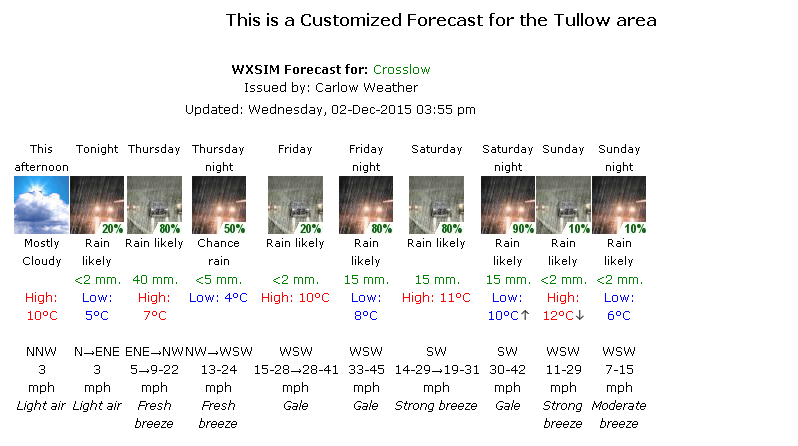
    My WXSIM forecast just updated, based on GFS
    WXSIM_F.png


  • Registered Users Posts: 18,069 ✭✭✭✭JCX BXC


    Met Eireanns own 5 day forecast on their website looks interesting, quite user friendly too.
    http://www.met.ie/forecasts/5day-ireland.asp


  • Registered Users Posts: 1,479 ✭✭✭Hooter23


    This wind chart is showing violent storm force 11 winds Friday evening...I think

    http://www.myweather2.com/streamline/player.aspx?Streamline=2#


  • Registered Users Posts: 1,979 ✭✭✭squarecircles


    Violent storm force 11 on the west coast Friday evening on this chart.


  • Registered Users Posts: 6,235 ✭✭✭Oneiric 3


    370444.jpg

    New Moon


  • Moderators, Home & Garden Moderators, Science, Health & Environment Moderators Posts: 17,595 Mod ✭✭✭✭DOCARCH


    Desmond...that's the next storm name due!


  • Registered Users Posts: 11,134 ✭✭✭✭maquiladora


    UKMO for noon Friday. Strong winds approaching the west coast.

    LRRLUdi.gif


  • Registered Users Posts: 18,069 ✭✭✭✭JCX BXC


    Storm Desmond then it seems :P


  • Registered Users Posts: 6,235 ✭✭✭Oneiric 3


    The wind from this system may only be half the story, at least according the the latest ECM, which has the frontal zone wavering over the mid-west and midlands for 30 hours solid, bringing the risk of some prolonged and/or heavy spells of rain.

    370448.PNG

    Looks particularly dodgy for N.Munster in through parts on N Leinster/S Ulster right through Friday night and throughout Saturday. Whether the evening's run has this nailed on though is the big question.

    New Moon


  • Advertisement
  • Registered Users Posts: 5,803 ✭✭✭Chris_5339762


    Vanilla GFS is showing a good lot of rain all over the weekend. Torrential for ~30 hours in places.


Advertisement