Advertisement
If you have a new account but are having problems posting or verifying your account, please email us on hello@boards.ie for help. Thanks :)
Hello all! Please ensure that you are posting a new thread or question in the appropriate forum. The Feedback forum is overwhelmed with questions that are having to be moved elsewhere. If you need help to verify your account contact hello@boards.ie
Hi all! We have been experiencing an issue on site where threads have been missing the latest postings. The platform host Vanilla are working on this issue. A workaround that has been used by some is to navigate back from 1 to 10+ pages to re-sync the thread and this will then show the latest posts. Thanks, Mike.
Hi there,
There is an issue with role permissions that is being worked on at the moment.
If you are having trouble with access or permissions on regional forums please post here to get access: https://www.boards.ie/discussion/2058365403/you-do-not-have-permission-for-that#latest

GIS Help Clinic

1235

Comments

  • Closed Accounts Posts: 85 ✭✭YoureATowel


    mango13 wrote: »
    hey guys! stunning post :O !!! i m personally stuck on the phase of i importing corine colours into the attribute table of the relevant polygons.. i ve already joined the polygons with the colour settings which are stored in a different column (RGB format, say: 255-255-000), based on code 00 and things seem that they are ok by now. The problem is i cant automatically assign colours to the same land type codes.. Instead I have to pick them manually from properties, and then typing the rgb code to find the proper colour.. Is there any way to make it work? YoureAtowel, you had some instructions, but still i cant understand whats going wrong.. thanx for the input..:)

    Using Tools-Style-Style manager I was able to create the attached .Style file.

    The file contains a series of Fill Symbols based on the RGB colour scheme in the clc_legend file.

    Assuming that you have followed the steps in the previous post you should have joined the attributes, including the RGB field, of the clc_legend file to your feature class. Follow these steps to symbolise the features according to the RGB field.


    1. Download the attached file, RGB.style.

    2. Right click on your feature class in the ArcGIS Table of Contents window. Select Properties and then the Symbology tab.

    3. Under Show select Categories - Match to symbols in a style.

    4. For Value Field select RGB.

    5. For Match to symbols in Style select Browse. Navigate to RGB.style that you downloaded in Step 1 and select Open.

    6. Next click on Add Values. On the Add Values dialog select Complete List. Select all the generated values and press OK.

    7. Back on the Layer Properties dialog select Match Symbols. The relevant symbology in the Style file is now applied to value in the RGB field of each feature.

    8. Click on OK to dismiss the Layer Properties window and to see the updated symbology.


  • Registered Users Posts: 6 mango13


    Thanks for the detailed instructions, mate!Flawless!!It's done!:) Well, what I could not do was to create the style at the Style Manager.. I suppose you did it the good old "batch" way, not adding each colour separately for every code, right? If yes, how did you do it, if I am allowed to ask?:)


  • Closed Accounts Posts: 85 ✭✭YoureATowel


    mango13 wrote: »
    Thanks for the detailed instructions, mate!Flawless!!It's done!:) Well, what I could not do was to create the style at the Style Manager.. I suppose you did it the good old "batch" way, not adding each colour separately for every code, right? If yes, how did you do it, if I am allowed to ask?:)

    The .Style file can be created manually in ArcView or automatically using ArcObjects programming.

    1) To create the file manually, first go to Tools-Styles-Style Manager.

    2) Click on Styles, scroll to the bottom of the list and select Create New. Give the new file a suitable name and press Save. The new Style is added to the Style Manager.

    3) Expand the new Style by clicking on the + button next to its name. Click on the Fill Symbols folder to highlight it. The next step is to add the required fill symbols.

    4) Right click on the empty panel on the right-hand-side of the Style Manager. Select New-Fill Symbol, the Symbol Property Editor Opens. Set Type to Simple Fill Symbol. Next press the Color button and then More Colors. Enter the RGB values from the clc_legend.csv file.

    For example the first entry in the clc_legend.csv file is 230-000-077. In the Color Selector enter 230 for Red, 000 for Green and finally 077 for Blue. Click OK.

    5) Click on the Outline Color button, select No Color. Set Outline Width to 0. Click OK and rename the newly created symbol to 230-000-077.

    6) Repeat steps 4 & 5 for each entry in the clc_legend.csv file.


    The alternative approach is to automatically generate the Styles file using VBA and ArcObjects. The process creates a blank Style file. It then reads each entry in the clc_legend.csv in turn, creates a symbol and symbolises it based on the entry in the RGB field. I used this method to create the file attached above.


  • Registered Users Posts: 6 mango13


    YoureATowel, YourePureGold! Cheers, my friend!!!


  • Registered Users, Registered Users 2 Posts: 487 ✭✭DBCyc


    Alright guys. I have some Mapinfo files that I want to use in ArcGIS 10 (.dat, .id, .map, .tab files). What is the best way to use them in ArcGIS - can you convert to a geodatabase or read them directly? Thanks


  • Closed Accounts Posts: 85 ✭✭YoureATowel


    DBCyc wrote: »
    Alright guys. I have some Mapinfo files that I want to use in ArcGIS 10 (.dat, .id, .map, .tab files). What is the best way to use them in ArcGIS - can you convert to a geodatabase or read them directly? Thanks

    If you have MapInfo then use its Universal Translator to export the files to ESRI shapefile format. This function located under the Tools menu.

    Check out this website for a free trial.


    If you only have access to ArcGIS then check to see if you have its Data Interoperability extension. This is located under Tools-Extensions. Once turned on you can access your Tab files in ArcCatalog as if they are in native ESRI format.

    A free trial is available here.


    A third option is to install FME Desktop.

    A trial version can be downloaded here.


  • Registered Users, Registered Users 2 Posts: 3,803 ✭✭✭El Siglo


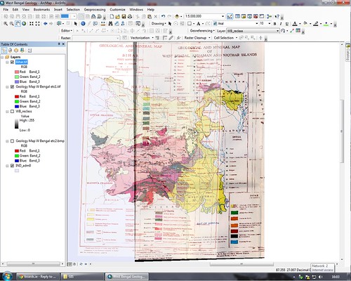
    I have a geological map saved as a tif file format that I want to start digitising using Arc 10. I've been having some trouble with two aspects of this that I was hoping to get some clarification on.

    The map is of a state in India, it has known locations on it that I can match up with XY coordinates and georeference these. However, I'm lost on the right projection. I did have a projection of WGS84 (14N) for India but it didn't work and the map was sideways and the coordinates didn't match correctly. I'm not sure now what coordinate system to use with the tif file and it's not working when I've tried other systems, it doesn't show any coordinates on the bottom of the screen when I move the mouse around. Is there a way of using the right projection and georeferencing the points?

    The second issue is the digitising bit. There's a lot to digitise and I was told that Arc Scan can do some of this work, I've never used it and I've tried to digitise by drawing polygons around the parts I want. However, this is taking far too long and I'm pushed for time, is there anyway that I can "train" the program to digitise parts of the map automatically? Essentially what's the most efficient way that I can digitise the map?

    I'd appreciate any information that anyone could offer! :D


  • Registered Users, Registered Users 2 Posts: 3,803 ✭✭✭El Siglo


    This is about as far as I've gotten.
    6298717433_a4274cb355.jpg

    The two tiffs (one is at 50% transparency) are georeferenced to the base map (purple). The problem now is converting all of these into a polygon shapefile. Apart from drawing the polygons which would take ages given I'm on a slow computer that is prone to crashing, does anyone know of a way that I can make shape files out of these? I've tried reclassifying one of them, I've tried nearly everything and it doesn't seem to work at all. Any suggestions would be most welcome.


  • Registered Users, Registered Users 2 Posts: 610 ✭✭✭muckish


    You need a raster2vector converter. Here's one that has a free trial. I don't know how good it is or what's in the trial version etc but might be worth giving it a go. http://www.cnccontrols.com/raster2vector.asp
    FME might be able to do some raster coercer transformations as well.


  • Advertisement
  • Registered Users, Registered Users 2 Posts: 11,983 ✭✭✭✭expectationlost


    is there batch ITM to utm etc converter out therer this one is unavailable :/http://www.osi.ie/en/alist/co-ordinate-converter-tool.aspx


  • Registered Users Posts: 225 ✭✭ManAboutCouch


    I asked OSi about their online converter yesterday, apparently the company that supplied it has ceased trading:

    https://twitter.com/#!/OrdnanceSurveyI/status/174141993646174208

    If you have access to a desktop GIS it should be a matter of a few clicks to convert the data. For example, in MapInfo, just use the in-built 'Co-ordinate Extractor' to add non-native projections to your table.


  • Registered Users, Registered Users 2 Posts: 11,983 ✭✭✭✭expectationlost


    it won't be mapinfo that im using


  • Registered Users, Registered Users 2 Posts: 6,248 ✭✭✭Rowley Birkin QC


    Hi all, looking for a, preferably, free software that can be used to generalise shapefiles in order to reduce their overall size while maintaining a reasonable degree of accuracy and maintaining boundaries between features.

    I've tried Q-GIS, admittedly very briefly, but found that features crossed boundaries.

    Also looking at purchasing FME to do this but obviously free is better.

    Thanks in advance.


  • Closed Accounts Posts: 4,116 ✭✭✭RDM_83 again


    Hi this is a really basic question (apologies) and its really bugging me that I can;t remember how to do this (or find an answer on google).

    But I can't seem to add the RMP data that you download from Archaeology.ie's map viewer to ArcGis 9.3. I download the file selecting county, monument, type, co-ordinate system, and select file type .shp

    Create a new project in ArcGis desktop, click on the little + button that adds data (having linked in folder etc) however the files I download from archaeology.ie don't seem to appear, other shapefiles I have from previous tutorials and ones downloaded from other sources do appear.

    If I try downloading as a File Geodatabase (.gdb) this is also not visible, however if I unzip and extract the Geodatabase I can open one file, however this file is simply the SMR zones and is not much use.

    I'm sure I'm making a simple error here but at the minute can't for the life of me think what it is.


  • Registered Users, Registered Users 2 Posts: 6,248 ✭✭✭Rowley Birkin QC


    Hi this is a really basic question (apologies) and its really bugging me that I can;t remember how to do this (or find an answer on google).

    But I can't seem to add the RMP data that you download from Archaeology.ie's map viewer to ArcGis 9.3. I download the file selecting county, monument, type, co-ordinate system, and select file type .shp

    Create a new project in ArcGis desktop, click on the little + button that adds data (having linked in folder etc) however the files I download from archaeology.ie don't seem to appear, other shapefiles I have from previous tutorials and ones downloaded from other sources do appear.

    If I try downloading as a File Geodatabase (.gdb) this is also not visible, however if I unzip and extract the Geodatabase I can open one file, however this file is simply the SMR zones and is not much use.

    I'm sure I'm making a simple error here but at the minute can't for the life of me think what it is.

    Have just downloaded a sample dateset there and opened it using eSpatial with no issues.

    Are you sure you are unzipping the Output file it gives you before trying to add it to Arc?


  • Advertisement
  • Closed Accounts Posts: 4,116 ✭✭✭RDM_83 again


    Ok I'm thinking there's something a bit funny with the way I'm downloading from archaeology.ie, because trying this at home the first time the file came down didn;t show up as a zip but retried a few times and a unzippable file came down. So hopefully thats all the issue is.

    Thanks for the help though.


  • Registered Users, Registered Users 2 Posts: 6,248 ✭✭✭Rowley Birkin QC


    Bit of a long shot but would anyone have decimal degrees coordinates of the Luas stops or know where to get them?

    Thanks


  • Registered Users, Registered Users 2 Posts: 487 ✭✭DBCyc


    Bit of a long shot but would anyone have decimal degrees coordinates of the Luas stops or know where to get them?

    Thanks

    They should be included in the Points shapefile (Type: tram_stop) of the OSM data for the "ireland-and-northern-ireland.shp.zip" available here:

    http://download.geofabrik.de/osm/europe/


  • Closed Accounts Posts: 4,116 ✭✭✭RDM_83 again


    I'm sure this is a ridiculously easy thing to do but can't seem to find the method, but

    I want to add the characteristics of a number of separate shapefiles (e.g elevation (i have a TIN for this), landuse from corine data etc) to a shapefile(or its attribute table) that is made up of simple points, e.g point at XY has the data for the other shapefiles at point XY.

    Thanks, I'm sure this is very easily done.

    ps this is in ArcGis 10, with most extensions working


  • Closed Accounts Posts: 4,116 ✭✭✭RDM_83 again


    ^^^
    Mods please delete this post (or readers ignore, problem was solved, simple file compatibility issues had me presuming the intersect tool was not the right tool to use)


  • Advertisement
  • Registered Users Posts: 837 ✭✭✭Subpopulus


    Hi,

    I'm new to the GIS business, and have decided to use QGIS. I'm a caver and recently have taken to creating a map of all known cave sites on the Truskmore Massif. I have a few problems that I'm trying to get my head around.

    Firstly:
    All the existing grid references are in Irish Grid. I have a huge Excel file with the locations of all known caves in Ireland and would like to be able to load this onto a OSM map giving a general distribution of all the caves in Ireland. I've so far been painstakingly converting all Irish Grid data into ITM using an online converter, and then loading that data into QGIS using tab delineated format. Is there any way I can load the excel file into QGIS with the Irish Grid data? This would save a lot of bother.

    Secondly:
    How do I apply a .style file to a shapefile in QGIS? I've downloaded a packaged shapefile from the GSI (to be found here). This should colour the various polygons according to the varying rock formations. I understand that QGIS uses a .qml file for styles but the style layer that comes with the package is a .style file, which my computer recognizes as a Sketchup style file. There's over a thousand rock types in the shape file, so being able to diffenciate them is quite important. Anyone know how to solve this.

    Thirdly:
    I forgot what my third question was. I'll probably remember in a few days time.

    Apologies if I haven't worded my questions well. I'm a complete novice with regard to GIS and am bewildered by the huge array of filetypes and acronyms that get bandied about.


  • Registered Users Posts: 1,161 ✭✭✭BetterCallSaul


    Subpopulus wrote: »
    Hi,

    I'm new to the GIS business, and have decided to use QGIS. I'm a caver and recently have taken to creating a map of all known cave sites on the Truskmore Massif. I have a few problems that I'm trying to get my head around.

    Firstly:
    All the existing grid references are in Irish Grid. I have a huge Excel file with the locations of all known caves in Ireland and would like to be able to load this onto a OSM map giving a general distribution of all the caves in Ireland. I've so far been painstakingly converting all Irish Grid data into ITM using an online converter, and then loading that data into QGIS using tab delineated format. Is there any way I can load the excel file into QGIS with the Irish Grid data? This would save a lot of bother.

    Secondly:
    How do I apply a .style file to a shapefile in QGIS? I've downloaded a packaged shapefile from the GSI (to be found here). This should colour the various polygons according to the varying rock formations. I understand that QGIS uses a .qml file for styles but the style layer that comes with the package is a .style file, which my computer recognizes as a Sketchup style file. There's over a thousand rock types in the shape file, so being able to diffenciate them is quite important. Anyone know how to solve this.

    Thirdly:
    I forgot what my third question was. I'll probably remember in a few days time.

    Apologies if I haven't worded my questions well. I'm a complete novice with regard to GIS and am bewildered by the huge array of filetypes and acronyms that get bandied about.


    http://qgis.spatialthoughts.com/2012/01/importing-spreadsheets-or-csv-files-to.html

    Do you need the specific colours created with the pre made style file?

    I'm assuming you tried the style - categorised - selecting the field of rock names or formations which should be in the attribute table and classifying to that.

    I've not really used QGIS so don't know of any way to apply a .style unfortunately.


  • Registered Users Posts: 837 ✭✭✭Subpopulus


    http://qgis.spatialthoughts.com/2012/01/importing-spreadsheets-or-csv-files-to.html

    Do you need the specific colours created with the pre made style file?

    I'm assuming you tried the style - categorised - selecting the field of rock names or formations which should be in the attribute table and classifying to that.

    I know how to add a csv/tdl file to QGIS. The problem is Irish Grid references which have a letter before them. QGIS seems to be unable to deal with the letter, and I've no idea whether I can process Irish Grid references at all without laboriously converting them to ITM.

    In any case I've moved onto more pertinent problems. I'm trying to map a series of sites in Papua New Guinea and I have a pair of maps of the area. Unfortunately, any attempt to georeference these maps leads to incredibly distorted maps.

    I'm getting the coordinates for the georeferencing off of Google Maps (this is WGS 84 isn't it?). I've been careful to use WGS 84 at all stages of the process and still I end up with maps that are plainly wrong. I've experimented with several transformation types, but these generally lead to even worse results - maps flipped upside down and back to front sometimes. Does anyone have any idea what might be happening?


    The georeferencer panel
    ScreenShot2012-09-17at224053.png


    The map severely compressed left-right and displaced from the georeferencing points. The points themselves seem to be located correctly.
    ScreenShot2012-09-17at224222.png

    I've tried to take the georeferencing points off the map canvas but this invariably leads to QGIS freezing and refusing to take any points at all.


  • Registered Users, Registered Users 2 Posts: 17,958 ✭✭✭✭RuggieBear


    Have a gander at this page wrt the letters:

    http://www.nisra.gov.uk/geography/default.asp14.htm

    If you look at the two pictures, if you add the corresponding numbers from the bottom left of the grid square.

    eg for grid references starting with letter M, add 100000 to the easting and 200000 to the northing


  • Registered Users, Registered Users 2 Posts: 160 ✭✭NotCarrotRidge


    Subpopulus wrote: »
    Hi,

    I'm new to the GIS business, and have decided to use QGIS. I'm a caver and recently have taken to creating a map of all known cave sites on the Truskmore Massif. I have a few problems that I'm trying to get my head around.

    Firstly:
    All the existing grid references are in Irish Grid. I have a huge Excel file with the locations of all known caves in Ireland and would like to be able to load this onto a OSM map giving a general distribution of all the caves in Ireland. I've so far been painstakingly converting all Irish Grid data into ITM using an online converter, and then loading that data into QGIS using tab delineated format. Is there any way I can load the excel file into QGIS with the Irish Grid data? This would save a lot of bother.

    Would you be better off converting them from IG with letters to IG with numbers only in excel? Does QGIS not support IG?

    I'm kind of busy today, but if you can do that in excel I could convert them to ITM in Arc and re-export to a csv for you.


  • Closed Accounts Posts: 12 BernieMap


    Hi,
    any idea where I might get some good and free roads shapefiles for Ireland? Its for an art project. I tried OSM but its a bit messy.
    Thanks folks,
    Bernie


  • Registered Users Posts: 1,161 ✭✭✭BetterCallSaul


    BernieMap wrote: »
    Hi,
    any idea where I might get some good and free roads shapefiles for Ireland? Its for an art project. I tried OSM but its a bit messy.
    Thanks folks,
    Bernie

    http://www.diva-gis.org/gdata


  • Registered Users Posts: 1 kom_1985


    I am doing a GIS project for college to create a geodatabase. I know how to create a geodatabase and how to create domains and sub-types but what is confusing me is when i add in a shapefile e.g CSO small areas data, this data has an attribute table
    When i add in this shapefile to my geodatabase how can i show the domains and sub-types i created in the shapefile attribute table or can i?
    Any suggestions


  • Registered Users Posts: 19 blue412


    Maybe I'm all off here, but i think you might need to create a relate between the common attribute on your CSO data and the geodatabase you've created e.g. the townland name (or something that is common to both). There is a joins and relates tab in the properties section of each layer.

    It might be the case that you need to add new field in the CSO dataset to insert common attribute.

    If you give a specific example, it might help me know if what I'm saying is right.


  • Registered Users Posts: 1,161 ✭✭✭BetterCallSaul


    kom_1985 wrote: »
    I am doing a GIS project for college to create a geodatabase. I know how to create a geodatabase and how to create domains and sub-types but what is confusing me is when i add in a shapefile e.g CSO small areas data, this data has an attribute table
    When i add in this shapefile to my geodatabase how can i show the domains and sub-types i created in the shapefile attribute table or can i?
    Any suggestions

    I think this is what you're looking for:

    http://gis.stackexchange.com/questions/25975/load-shape-file-with-different-ftypes-into-a-gdb-feature-class-with-different-su


  • Advertisement
  • Moderators, Recreation & Hobbies Moderators, Science, Health & Environment Moderators Posts: 3,069 Mod ✭✭✭✭OpenYourEyes


    Hi everyone,

    I've got a few hundred Irish grid references that I need to plot on ArcGis, just wondering if anyone knew of a converter for a large number of grid references that they'd recommend? I've tried two with no real success! Any help appreciated!


  • Registered Users, Registered Users 2 Posts: 160 ✭✭NotCarrotRidge


    Hi everyone,

    I've got a few hundred Irish grid references that I need to plot on ArcGis, just wondering if anyone knew of a converter for a large number of grid references that they'd recommend? I've tried two with no real success! Any help appreciated!

    You probably need to give us a bit more info before we can give you a decent answer. What format is your data in? Is it excel/csv/shp/tab/something else?

    What GIS software are you using? What do you want to end up? A table or a map, or a spreadsheet?


  • Moderators, Recreation & Hobbies Moderators, Science, Health & Environment Moderators Posts: 3,069 Mod ✭✭✭✭OpenYourEyes


    You probably need to give us a bit more info before we can give you a decent answer. What format is your data in? Is it excel/csv/shp/tab/something else?

    What GIS software are you using? What do you want to end up? A table or a map, or a spreadsheet?

    Apologies! All my grid references are in a single column on an excel spreadsheet.

    I'm using ArcGIS 10.

    I want all of those points/squares marked on a map, but if I can convert them all from Irish grid references into a more universal system then i think I know where to go from there!


  • Registered Users, Registered Users 2 Posts: 610 ✭✭✭muckish


    Hi everyone,

    I've got a few hundred Irish grid references that I need to plot on ArcGis, just wondering if anyone knew of a converter for a large number of grid references that they'd recommend? I've tried two with no real success! Any help appreciated!
    Did you get this sorted?


  • Moderators, Recreation & Hobbies Moderators, Science, Health & Environment Moderators Posts: 3,069 Mod ✭✭✭✭OpenYourEyes


    muckish wrote: »
    Did you get this sorted?

    Found out what values to add to replace the letters for the Irish grid referencing system and did it the old fashioned way!


  • Registered Users Posts: 1 The Randy Disher Project


    Hello,

    Can anyone recommend for me opensource GIS software for tree mapping that runs on Mac and windows and preferably with applications for use on tablets, iphone, that sort of thing.

    Would really appreciate the help!


  • Registered Users Posts: 225 ✭✭ManAboutCouch


    Most commercial desktop GIS software (MapInfo / ArcGIS) is PC only, but QGIS runs nicely on both, and it's open source. The learning curve can be a little bit steep, but that's par for the course with Open Source software.

    There is a version for Android, but I haven't used it myself: http://hub.qgis.org/projects/android-qgis


  • Registered Users, Registered Users 2 Posts: 6,248 ✭✭✭Rowley Birkin QC


    Hey, does anyone have a shapefile (which they can share) that shows Dublin Postal Districts? Cheers!


  • Registered Users Posts: 225 ✭✭ManAboutCouch


    Not a shapefile, but you can get them from OpenStreetMap in geoJSON, KML or gpx by using the very excellent Overpass Turbo service. Here's a preformatted query that should return the data you need, just choose 'Export' and select your preferred format.


  • Advertisement
  • Registered Users, Registered Users 2 Posts: 6,248 ✭✭✭Rowley Birkin QC


    Cheers. Downloaded as GEOJSON and opened in QGIS but some are appearing as polygons and others as line features.


  • Registered Users Posts: 225 ✭✭ManAboutCouch


    You might have to rebuild the topology (not a strong point with OSM data)


  • Registered Users, Registered Users 2 Posts: 6,248 ✭✭✭Rowley Birkin QC


    Cheers. That Overpass Turbo is a pretty nifty piece of kit.


  • Registered Users Posts: 225 ✭✭ManAboutCouch


    Indeed it is.

    To get the most from it you might need to get familiar with how OpenStreetMap tags (or Key/Value pairs) work. There's an exhaustive list of tags used in Ireland maintained here: http://taginfo.openstreetmap.ie/ which is updated daily.

    The OSM Wiki maintains the global list. As you can imagine there can be some cases of disagreements / overlaps etc. as accepted usage is constantly evolving.


  • Registered Users Posts: 5 gre2401


    Hi, I'm looking for shapefile or polyline of all public roads in Ireland. I have to import it to Qgis. I managed to downlaod one for the major national roads and motorways from

    http://www.diva-gis.org/gdata

    but as I said it only shows major ones.

    Any clues will be helpful.

    Thanks.


  • Registered Users Posts: 225 ✭✭ManAboutCouch


    It might not have *every* road in the country, but OpenStreetMap has almost all of them, available for free under an open licence. Coverage is improving daily as editors like you and me add more. You can download shapefiles of OSM data for Ireland from GeoFabrik here: http://download.geofabrik.de/europe/ireland-and-northern-ireland.html


  • Advertisement
  • Registered Users Posts: 5 gre2401


    It might not have *every* road in the country, but OpenStreetMap has almost all of them, available for free under an open licence. Coverage is improving daily as editors like you and me add more. You can download shapefiles of OSM data for Ireland from GeoFabrik here: http://download.geofabrik.de/europe/ireland-and-northern-ireland.html
    Thanks for your help, I was just going through some Qgis tutorial and it mentioned about open street map and how easy is to export desired piece of land.


  • Registered Users Posts: 5 gre2401


    The stuff from geofabrik is brilliant. This is exactly what I was looking for. All in 1.

    Thanks for that ManAboutCouch !!!


  • Registered Users Posts: 225 ✭✭ManAboutCouch


    You're welcome.

    One issue to watch out for with the GeoFabrik extracts is that only contain a small subset of the features in the OSM database. Multipart features (think lakes with islands etc.) aren't in the files nor are the majority of point features.

    If you need something that isn't included as standard you have a few options:
    You can pay GeoFabrik to tailor their downloads for you (this is one of the ways their business funds itself) details here: http://www.geofabrik.de/data/shapefiles.html

    You could use the Overpass-Turbo service I mentioned above.

    Or use the .pbf extracts which are on the same download page as the shapefiles. If you're working with the .pbf's you'll need to import them into some sort of database to use them. PostGIS is the usual (open source) recommendation, but there is a bit of a learning curve involved.


  • Registered Users Posts: 10 del77


    Hi all, i need to access GIS mapping data for the forestry of Ireland for my thesis project , i have contacted both Coillte and ITGA but as expected they are extremely slow at responding. Does anyone know where i might be able t track down these maps ?? any input greatly received , cheers


  • Registered Users Posts: 225 ✭✭ManAboutCouch


    Have you tried contacting The Forest Service?

    Details of who to contact here: http://www.agriculture.gov.ie/forestservice/forestservicegeneralinformation/abouttheforestservice/forestcoverdatasets/

    Alternatively, is the Corine Landcover dataset of any use to you? It's downloadable in shapefile format, details here: http://gis.epa.ie/GetData/Download


  • Advertisement
Advertisement