Advertisement
If you have a new account but are having problems posting or verifying your account, please email us on [email protected] for help. Thanks :)
Hello all! Please ensure that you are posting a new thread or question in the appropriate forum. The Feedback forum is overwhelmed with questions that are having to be moved elsewhere. If you need help to verify your account contact [email protected]

GIS Help Clinic

2456710

Comments

  • Registered Users Posts: 6,182 ✭✭✭Tiriel


    I actually can't wait to work this out tomorrow, having spent hours doing it over and over incorrectly!! Thank you so much for your time.. I will let you know how I get on!


  • Registered Users Posts: 6,182 ✭✭✭Tiriel


    It worked!! I would never have known to do it like that - thank you so much! I can now go and continue working instead of chasing my tail!


  • Registered Users Posts: 6,212 ✭✭✭Rowley Birkin QC


    Anyone have any idea where road layers would be available? Specifically for Cork County.

    Cheers.


  • Closed Accounts Posts: 74 ✭✭lil*lady


    I'm starting to go a bit cuckoo at the moment.
    I've a project to work on that involves using LiDAR in GIS. Basically I've to make a hillshade from that and deduce the various features - sounds easy enough...except I'm really stuck and now my data is coming out all pixelated and even though it looks like it's 3D from afar when you zoom in to get a closer look it's just flat...
    Would anyone have any ideas?


  • Registered Users Posts: 6,212 ✭✭✭Rowley Birkin QC


    Anyone have any idea where road layers would be available? Specifically for Cork County.

    Cheers.

    Anyone at all?


  • Advertisement
  • Registered Users Posts: 6,212 ✭✭✭Rowley Birkin QC


    I'm also trying to export .KMZ files from Google Earth into ArcMap. As I understand it these are in WGS84 by default so I'm skipping the first step as listed above in post #31. I can't get them to sit correctly on my map though when I finish the process and and convert them to ITM.

    Any ideas?


  • Closed Accounts Posts: 85 ✭✭YoureATowel


    I'm also trying to export .KMZ files from Google Earth into ArcMap. As I understand it these are in WGS84 by default so I'm skipping the first step as listed above in post #31. I can't get them to sit correctly on my map though when I finish the process and and convert them to ITM.

    Any ideas?

    You only need to use Step 3 from Post #31, ie Use ArcToolbox-Data Management Tools-Projections And Transformations-Feature-Project to change the coordinate system from WGS84 to ITM. For Output Coordinate System go to Coordinate Systems\Projected Coordinate Systems\National Grids and select IRENET95 Irish Transverse Mercator.prj. For Geographic Transformation use IRENET95_To_WGS_1984_1.

    However, if you are combining data from Google earth .KMZ files with data from other sources than you may encounter problems due to the varying accuracies of the datasets. For example, I have noticed discrepencies of 20 - 100 meters between lines digitised from Google Earth and those same features on 40cm orthophotography.

    The image below shows road centerlines of Marino, Dublin digitised from Google Earth and sumperimposed on the commercially available 40cm ortho. The discrepency here is in the order of 70m.

    Marino.jpg


  • Closed Accounts Posts: 85 ✭✭YoureATowel


    lil*lady wrote: »
    I'm starting to go a bit cuckoo at the moment.
    I've a project to work on that involves using LiDAR in GIS. Basically I've to make a hillshade from that and deduce the various features - sounds easy enough...except I'm really stuck and now my data is coming out all pixelated and even though it looks like it's 3D from afar when you zoom in to get a closer look it's just flat...
    Would anyone have any ideas?

    First of all I wouldn't be worried if your hillshade appears to be "just flat" when you zoom in. That's obviously going to happen. It's the same as if you try to watch TV from a distance of 5cm, you're just going to get a pixelated version of what appears normal at 5 meters.

    Ensure that the resolution of your hillshade is not smaller than the resolution of the input surface generated from your LIDAR data. It's probably preferable that they're the same resolution.

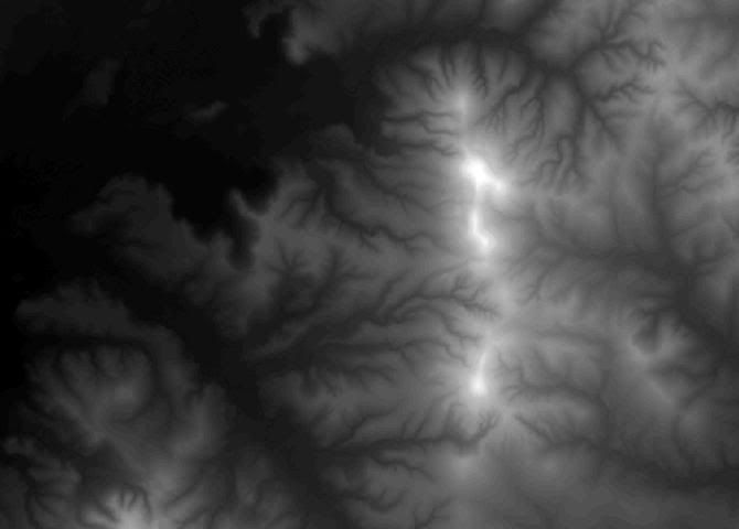
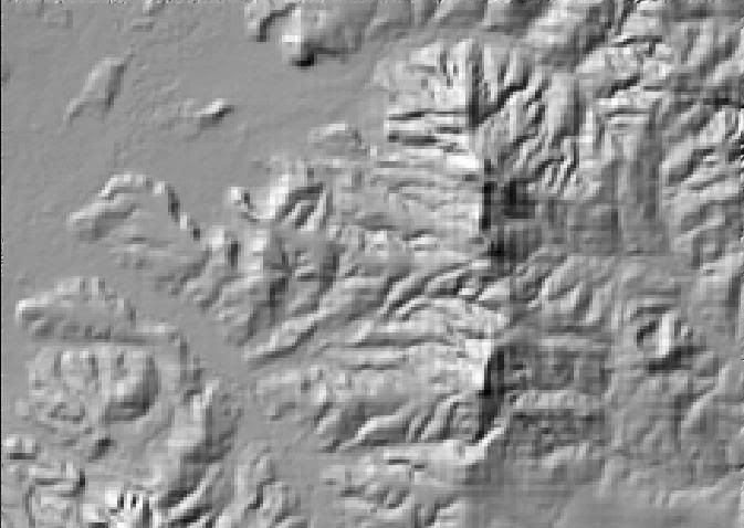
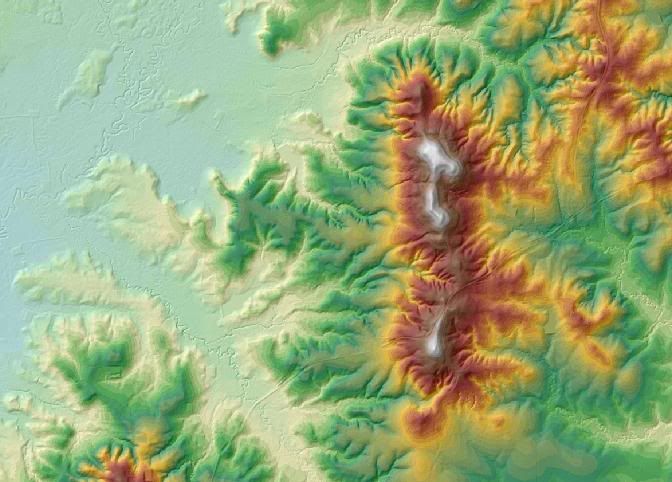
    I generated the following surface from public domain LIDAR data, it has a resolution of 5m.

    Surface1.jpg

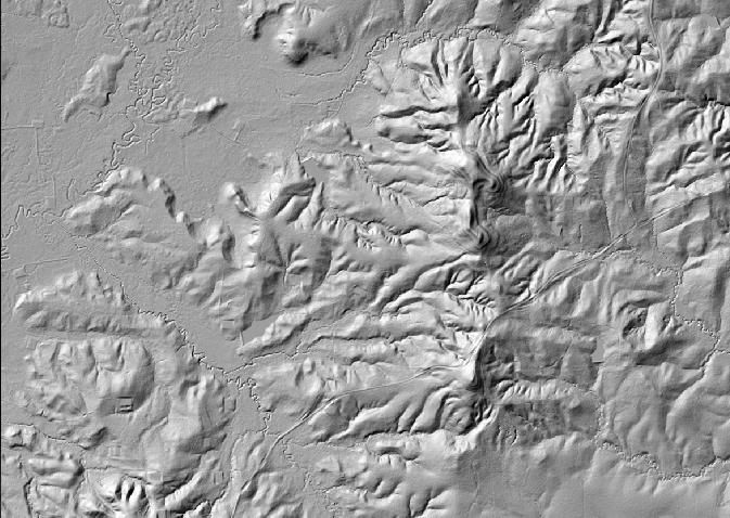
    The surface was then used to create this hillshade, also with a 5m resolution.

    Hillshade1.jpg

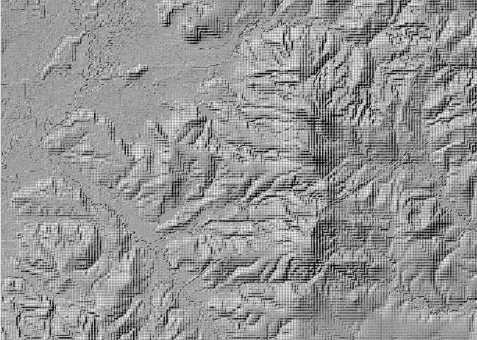
    Look what happens when I use a 1m resolution.

    Hillshade2.jpg

    This is at 25m.

    Hillshade3.jpg

    So dramatically increasing or decreasing the hillshade resolution from that of the input surface produces unsatisfactory results.

    Now lets return to the 5m resolution hillshading. Even though this random example isn't exactly ideal I can still easily pick out the rivers, roads and even lakes

    By classifying the surface, making it transparent and placing it over the hillshading you can get even more dramatic results.

    Hillshade4.jpg

    A 3d scene, incorporating small scale raster mapping of the same area, can also be used to confirm suspected features on the hillshading.

    Map2.jpg


  • Registered Users Posts: 6,212 ✭✭✭Rowley Birkin QC


    I've followed the transformation procedure, both my layers are projected in ITM95 and yet there are massive discrepancies (>100 miles). Any common problems that I can check for?

    I think it's about time we started paying you a wage Youreatowel!! Thanks for all the help so far.


  • Closed Accounts Posts: 85 ✭✭YoureATowel


    I've followed the transformation procedure, both my layers are projected in ITM95 and yet there are massive discrepancies (>100 miles). Any common problems that I can check for?

    I think it's about time we started paying you a wage Youreatowel!! Thanks for all the help so far.

    Is this discrepancy between the two layers you projected to IRENET95 ITM or is it between both these layers and data from another source?

    If it's the former than you have obviously projected one of your layers incorrectly.

    If it's the latter then check the XY Coordinate System tab under Properties of the shapefile in ArcCatalog. It is possible that such a file may be in Irish National Grid but this coordinate system has not being associated with the file. Such a file will have an unknown coordinate system.

    Can you make your unprojected files available, on Rapidshare.com for example?


  • Advertisement
  • Closed Accounts Posts: 74 ✭✭lil*lady


    Thanks very much for your help YoureATowel - very much appreciated, forgot the auld password hence why it took me so long getting back to you, you'd think after the many years that I've been on here that I'd remember it...

    There's one other thing I'm having issues with, which is changing the coordinate system.

    It's in a British system, but I'm trying to get it into the TSM65 Irish one, but it just won't work, maybe I'm doing the wrong thing or maybe there's a shortcut but ArcGIS is asking me for conversion factors, has anyone else come across this?

    All the help is much appreciated thankn you!


  • Closed Accounts Posts: 85 ✭✭YoureATowel


    lil*lady wrote: »
    Thanks very much for your help YoureATowel - very much appreciated, forgot the auld password hence why it took me so long getting back to you, you'd think after the many years that I've been on here that I'd remember it...

    There's one other thing I'm having issues with, which is changing the coordinate system.

    It's in a British system, but I'm trying to get it into the TSM65 Irish one, but it just won't work, maybe I'm doing the wrong thing or maybe there's a shortcut but ArcGIS is asking me for conversion factors, has anyone else come across this?

    All the help is much appreciated thankn you!


    First of all I'm going to assume that your initial data is in OSGB British National Grid, which uses the Airy spheroid, and you want to convert to Irish National Grid, which uses the Airy Modified spheroid.

    If I had to carry out this transformation for a single XY coordinate pair by hand the method would be.

    Step 1. Convert OSGB XY to Airy Lat\Long.
    Step 2. Convert Airy Lat\Long to Airy XYZ (Geocentric Cartesian Coords).
    Step 3. Transform Airy XYZ to Airy Modified XYZ.
    Step 4. Convert Airy Modified XYZ to Airy Modified Lat\Long.
    Step 5. Finally convert Airy Modified Lat\Long to ING XY.

    Thankfully GIS software makes life much simpler. There are two ways you could do it. The first is the same as outlined in Post #31 above, I would always use this method.


    Method 1

    Using this method you will have to use WGS84 as a transitional stage. This is because by default the ArcToolbox component of ArcGIS doesn't have the necessary transformation parameters to carry out Step 3 outlined above.

    For Vector Data

    A. Use ArcToolbox-Data Management Tools-Projections And Transformations-Feature-Project to change the coordinate system from BNG to WGS84. For Output Coordinate System go to Coordinate Systems\Geographic Coordinate Systems\World and select WGS84.prj. For Geographic Transformation use OSGB_1936_To_WGS_1984_1.

    B. Use ArcToolbox-Data Management Tools-Projections And Transformations-Feature-Project to change the coordinate system from WGS84 to ING. For Output Coordinate System go to Coordinate Systems\Projected Coordinate Systems\National Grids and select Irish National Grid.prj. For Geographic Transformation use TM65_To_WGS_1984.

    For Raster Data

    A. Use ArcToolbox-Data Management Tools-Projections And Transformations-Raster-Project Raster to change the coordinate system from BNG to WGS84. For Output Coordinate System go to Coordinate Systems\Geographic Coordinate Systems\World and select WGS84.prj. For Geographic Transformation use OSGB_1936_To_WGS_1984_.

    B. Use ArcToolbox-Data Management Tools-Projections And Transformations-Raster-Project Raster to change the coordinate system from WGS84 to ING. For Output Coordinate System go to Coordinate Systems\Projected Coordinate Systems\National Grids and select Irish National Grid.prj. For Geographic Transformation use TM65_To_WGS_1984.


    Method 2

    1. Start ArcMap and select A new empty map.

    2. Select View then Data Frame Properties.

    3. Choose the Coordinate System tab. Under Select coordinate system double click on Predefined, Projected Coordinate System, National Grids and then select Irish National Grid, ie the coordinate system you want to project to.

    4. Add your OSGB data to the map. A warning should appear. Dismiss this by pressing Close. ArcView will automatically transform your data to Irish National Grid so that it can be displayed in the data frame.

    5. Right click on the newly added layer. Select Data-Export Data.

    6_Vector. For Use the same coordinate system as select the data frame. Give the output file a name and click on OK. This output file is now in Irish National Grid.

    6_Raster. For Spatial Reference select Data Frame (Current). Also select an appropriate output raster format.


  • Closed Accounts Posts: 74 ✭✭lil*lady


    That's really helpful thank you so very very very much, you've really helped me out of a bind. It's always the seemingly "easy" things that get me.
    YourATowel, if you ever need anything drop me a line!


  • Registered Users Posts: 6,212 ✭✭✭Rowley Birkin QC


    Is this discrepancy between the two layers you projected to IRENET95 ITM or is it between both these layers and data from another source?

    If it's the former than you have obviously projected one of your layers incorrectly.

    If it's the latter then check the XY Coordinate System tab under Properties of the shapefile in ArcCatalog. It is possible that such a file may be in Irish National Grid but this coordinate system has not being associated with the file. Such a file will have an unknown coordinate system.

    Can you make your unprojected files available, on Rapidshare.com for example?

    Nail on the head again, a friend helped me figure it out before I got back to this thread (read as; she told me how to do it!) but that was exactly the problem. Thanks again.


  • Registered Users Posts: 3,803 ✭✭✭El Siglo


    I'm a little stuck on the GIS myself (i.e. I've no experience of it and I'm pretty stuck).
    I'm trying to map a salt marsh in Co. Clare, so I sent off for the corine data from the EPA, got it in the post and that's where the problems start.

    Here's what I've managed to get done:
    picture.php?albumid=729&pictureid=6775

    Now I don't know what else to do or what I should be looking out for.

    I've also got GPS coordinates to put into it as well so, that's another issue.


  • Registered Users Posts: 6,182 ✭✭✭Tiriel


    El Siglo wrote: »
    I'm a little stuck on the GIS myself (i.e. I've no experience of it and I'm pretty stuck).
    I'm trying to map a salt marsh in Co. Clare, so I sent off for the corine data from the EPA, got it in the post and that's where the problems start.

    Here's what I've managed to get done:
    picture.php?albumid=729&pictureid=6775

    Now I don't know what else to do or what I should be looking out for.

    I've also got GPS coordinates to put into it as well so, that's another issue.

    I can't see your image there El Siglo!

    Just to note.. you can actually download the Corine 2006 datasets online and then project them following the steps outlined in this thread from Youratowel - I've done this for all of the Corine datasets in the past few weeks.

    Out of curiosity - what kind of timeframe did it take to get the data from the EPA? Was there any cost involved and what co-ordinate system did they provide them in?

    When you say GPS Co-Ordinates, do you need to put a point/shapefile at these locations?


  • Registered Users Posts: 3,803 ✭✭✭El Siglo


    Cork_girl wrote: »
    I can't see your image there El Siglo!

    It's a shit image anyway, just shows like three land uses but I don't know what else to do.
    Just to note.. you can actually download the Corine 2006 datasets online and then project them following the steps outlined in this thread from Youratowel - I've done this for all of the Corine datasets in the past few weeks.

    +1, that helps a fair bit, I'll give it a look over now.
    Out of curiosity - what kind of timeframe did it take to get the data from the EPA? Was there any cost involved and what co-ordinate system did they provide them in?

    Oh, feck all time it was really fast, I think I posted the forms on Thursday, package was delivered by Tuesday, it's just a cd with the data.
    When you say GPS Co-Ordinates, do you need to put a point/shapefile at these locations?

    Yeh, I've the northings and westings and want to put them onto a map somehow.


  • Closed Accounts Posts: 85 ✭✭YoureATowel


    El Siglo wrote: »
    I'm a little stuck on the GIS myself (i.e. I've no experience of it and I'm pretty stuck).
    I'm trying to map a salt marsh in Co. Clare, so I sent off for the corine data from the EPA, got it in the post and that's where the problems start.

    Here's what I've managed to get done:
    picture.php?albumid=729&pictureid=6775

    Now I don't know what else to do or what I should be looking out for.

    I've also got GPS coordinates to put into it as well so, that's another issue.

    What software are you using? Arcview 3.*, ArcGIS, MapInfo?


  • Registered Users Posts: 3,803 ✭✭✭El Siglo


    What software are you using? Arcview 3.*, ArcGIS, MapInfo?

    It was ArcGIS 9.2, it was on a college computer so it had the full package. I think? Yeh it was because it was on a computer with windows xp.


  • Closed Accounts Posts: 85 ✭✭YoureATowel


    El Siglo wrote: »
    It was ArcGIS 9.2, it was on a college computer so it had the full package. I think? Yeh it was because it was on a computer with windows xp.

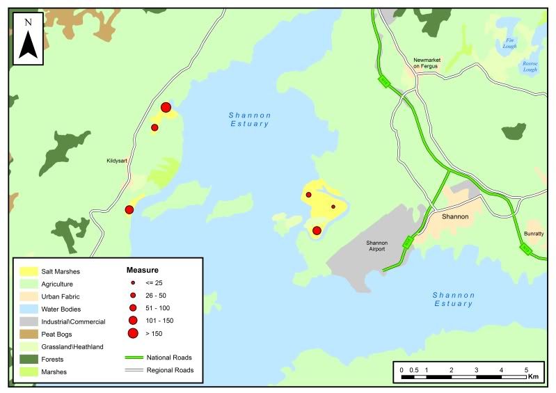
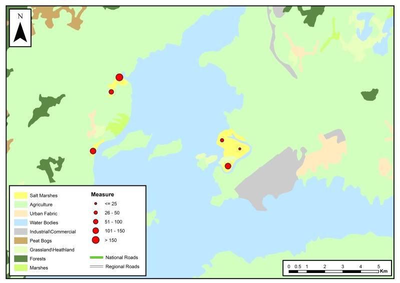
    This might give you a rough idea of what to aim for.

    Shannon_2.jpg

    I downloaded the data from the EEA website, projected it to Irish National Grid. The extent of the files make them quite unwieldy so I then selected out the data relevant to the study area.

    Next I began to group similar layer types. For example, I grouped Intertidal Flats, Water Courses, Water Bodies and Estuaries together and symbolised all four layers the same way.

    In the end I had consolidated the multiple layers that cover the study area into 9 new layers. Salt Marshes, Agriculture, UrbanFabric, Water Bodies, Industrial\Commercial, PeatBogs, Grasslands\Heathlands, Forests and InlandMarshes.

    I used Google Earth to digitise the roads and determine the road, lake, town etc names. I imported this linework into ArcMap and styled it accordingly.

    The next stage was to add a hypothetical point file. I made the assumption that each point reflects a scientific measurement of some type made at a specific location within the salt marshes.


    Adding XY Data to a map.

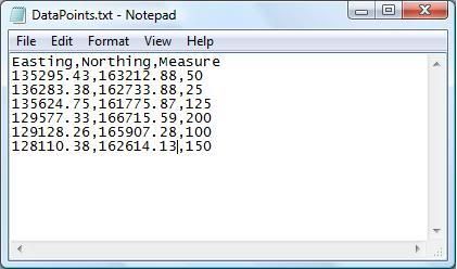
    1. Place all your Easting, Northing, Measurement data into a comma delimited text file. The first line in this file should be the Field Name of the subsequent data. The file should look something like this.

    DataPoints.jpg

    2. Add the textfile to ArcMap. Right click on the textfile name in the table of contents and select Display XY data.

    3. For X Field choose Easting, for Y Field choose Northing. For Coordinate System of Input Coordinates, click Edit, the Select and navigate to the required coordinate system, in this case Irish National Grid. Click Ok to the Object-ID Field warning.

    4. The XY Events are then added. You can now symbolise the points accordingly. I used Graduated Symbols based on the Measure field. The larger the Measure value, the larger the symbol will appear on the map.


    Finally I added a Legend, North Arrow and a Scalebar using the Insert menu.

    It might also be wise to state where you sourced your data.


  • Advertisement
  • Registered Users Posts: 6,182 ✭✭✭Tiriel


    Adding XY Data to a map.

    1. Place all your Easting, Northing, Measurement data into a comma delimited text file. The first line in this file should be the Field Name of the subsequent data. The file should look something like this.

    DataPoints.jpg

    2. Add the textfile to ArcMap. Right click on the textfile name in the table of contents and select Display XY data.

    3. For X Field choose Easting, for Y Field choose Northing. For Coordinate System of Input Coordinates, click Edit, the Select and navigate to the required coordinate system, in this case Irish National Grid. Click Ok to the Object-ID Field warning.

    4. The XY Events are then added. You can now symbolise the points accordingly. I used Graduated Symbols based on the Measure field. The larger the Measure value, the larger the symbol will appear on the map.


    Finally I added a Legend, North Arrow and a Scalebar using the Insert menu.

    It might also be wise to state where you sourced your data.

    I'm doing something similar at the moment, was trying to add points using the Tools add x,y data but my points seem to be completely out. The points I'm adding are from the location of Irish Prisons, which I hope to buffer according to the document here. It doesn't state what grid the co-ordinates are attached to, but when I assign them to ING it's definitely wrong. Is there something I'm missing? I just used an excel sheet with the different fields and the fields marked x and y for the wizard. :o
    http://www.iaa.ie/safe_reg/iaip/Published%20Files/AIP%20Files/ENR/EI_ENR_5_1_en.pdf
    The line relating to Portlaoise for exampe is this:
    ID Location x y
    EIP8 PORTLAOISE, LAOIS 530130.00 71800.00


  • Closed Accounts Posts: 85 ✭✭YoureATowel


    Cork_girl wrote: »
    I'm doing something similar at the moment, was trying to add points using the Tools add x,y data but my points seem to be completely out. The points I'm adding are from the location of Irish Prisons, which I hope to buffer according to the document here. It doesn't state what grid the co-ordinates are attached to, but when I assign them to ING it's definitely wrong. Is there something I'm missing? I just used an excel sheet with the different fields and the fields marked x and y for the wizard. :o
    http://www.iaa.ie/safe_reg/iaip/Published%20Files/AIP%20Files/ENR/EI_ENR_5_1_en.pdf
    The line relating to Portlaoise for exampe is this:
    ID Location x y
    EIP8 PORTLAOISE, LAOIS 530130.00 71800.00


    They're obviously geographic coordinates, likely to be WGS84.

    530130.00 is 53 01' 30" N or +53 01' 30" or +53.025
    71800.00 is 7 18' 00" W or -7 18' 00" or -7.3


  • Registered Users Posts: 3,803 ✭✭✭El Siglo


    YoureATowel, you are a legend! Thanks a million!:D That's really helpful so it is. I'm absolutely useless at GIS and have zero experience with it (3 days during the masters).

    I just have a few specific questions though, I hope you don't mind answering.
    I downloaded the data from the EEA website, projected it to Irish National Grid. The extent of the files make them quite unwieldy so I then selected out the data relevant to the study area.

    Which data sets did you download? They cover all of Europe so how did you get it to 'focus' on Ireland so well?
    Next I began to group similar layer types. For example, I grouped Intertidal Flats, Water Courses, Water Bodies and Estuaries together and symbolised all four layers the same way.

    Is this when you're in ArcMap and your side bar you just arrange the different layers in order of preference and tick the boxes? How do you group the layers?
    In the end I had consolidated the multiple layers that cover the study area into 9 new layers. Salt Marshes, Agriculture, UrbanFabric, Water Bodies, Industrial\Commercial, PeatBogs, Grasslands\Heathlands, Forests and InlandMarshes.

    I'm a little lost on this step.
    I used Google Earth to digitise the roads and determine the road, lake, town etc names. I imported this linework into ArcMap and styled it accordingly.

    I'm pretty lost on this step as well.

    Thanks again for the help, I really really do appreciate it.


  • Registered Users Posts: 6,182 ✭✭✭Tiriel


    El Siglo wrote: »
    Which data sets did you download? They cover all of Europe so how did you get it to 'focus' on Ireland so well?

    You use the Selection tool and "Select by location". Select items from the Corine layer which are "located within" a layer which covers the extents of the area you need the Corine data for. So if you have an Irish Coastline or overall Ireland map - or ED's or whatever you are using - you use that as your background - only shapefiles located within that area will then be selected. Right click on the layer then, click on Selection and Create new layer from selected features. The layer created will then be a lot faster to load etc. and covers the area you need as opposed to all of Europe!


  • Closed Accounts Posts: 74 ✭✭lil*lady


    Hey guys,

    This might be a rookie mistake, but I'm trying to make very precise polygon, however every time I do up my polygon instead of having the subtle ins and outs of the shape (i.e. a lake) it comes out looking like a rectangle. Do I need to set some sort of tolerance or...? Also when I'm just starting to make my shape it won't allow me to save as I go, I have to wait until I've stopped making the shape to save, which then turns into a generic rectangle...any ideas?

    Secondly I also want to do lil arrows on my map to show the slope (see attachement) and hopefully break in slope, I've figured out how to do the slope in spatial analyst tools, but I'm a bit stuck after that, any ideas how I could do that?

    Thirdly, (again I apologise for the rookie question), but try as I might I can't get my snapping to work, say I draw one road and then draw another beside it (e.g. in a Y fasion), as close as i zoom in they always seem to be like : \ / and won't connect. How I can get them to snap together for roads I've already done and roads that I will do in the future?

    Very rookie questions I know, but I'm really stuck and my supervisor is no use to me whatsoever.

    Tad bit clueless. Any help appreciated.


  • Closed Accounts Posts: 85 ✭✭YoureATowel


    El Siglo wrote:
    Which data sets did you download? They cover all of Europe so how did you get it to 'focus' on Ireland so well?

    I Downloaded all the datasets from here. I also downloaded the Corine land cover 2000 classes and RGB color codes .csv file

    1. Go to View-Dataframe Properties-Coordinate System. For Select a coordinate system go to Predefined-Projected Coordinate Systems-National Grids and select Irish National Grid. ArcMap will now reproject any datasets added to the project to ING.

    2. Add all the Corine land cover datasets. A Geographic Coordinate Systems Warning appears. Click Transformations, under Using select TM65_To_ETRS_1989_1. Click OK and then Close on the original warning message. All the datasets are added in ING.

    3. In this case I'm only interested in the area around Shannon. The size and extents of the shapefiles makes them difficult to work with so I'm just going to focus on the Shannon area. File-Page and Print Setup, select a printer, paper size (I used A4) and set Orientation to Landscape. Now go to View-Layout View. Now use the Zoom In tool to zoom into the area of interest. The speed at which ArcMap redraws the layers shows how beneficial it will be to focus on just the area of interest. When satisfied that the map covers the correct area Bookmark it using Bookmarks-Create.

    4. Select all layers in the Table of Contents, right click and select Turn off. Go back to Data View, use the New Rectangle tool on the Drawing toolbar to draw a new graphic. Now go back to Layout View and ensure the rectangle now fills the area of interest.

    5. Now ensure the graphic rectangle is selected and click the Pause button at the bottom left of the dataframe. Now turn on all the layers. Go to Selection-Select By Graphic. All features that intersect the rectangle are selected.

    6. In the Table of Contents change from the Display tab to the Selection tab. Here you can see a count of the number of features selected in each layer. For each layer with selected data, return to the Display tab, right click on that layer and select Data-Export Data. For Export use Selected Features. For Use the same coordinate system as: use the data frame.

    7. Remove all shapefiles from the map and then add all the newly created ones. Use your bookmark to zoom to the area of interest.

    8. The minimum data required is now present and in a workable coordinate system. You can now start symbolising the layers.

    El Siglo wrote:
    Is this when you're in ArcMap and your side bar you just arrange the different layers in order of preference and tick the boxes? How do you group the layers?

    I'm a little lost on this step.


    I grouped certain layers together for housekeeping purposes. For example, by grouping Water Courses, Water Bodies and Estuaries together I can get them to behave as a single layer. Groups were based on data from Corine land cover 2000 classes and RGB color codes .csv file.

    1. Download the file from the website and add it to the map.

    2. Right click on clc_legend.csv on the Table of Contents and select Data-Export. Save the file as a dbf called JoinData.dbf, add it to the map and open the table.

    3. On the open table go to Options-AddField. Call the Field JoinField, for type select Text, for length input 3.

    4. Right click on the new field's name. Select Field Calculator. In Fields double click on CLC_CODE, then OK. Data from the CLC_CODE field is copied to the JoinField field. However, it is now in Text format which, in this case, allows us to join the data to the shapefiles.

    5. For each layer in turn right click, Joins and Relates-Joins. The Join Data dialog now opens. For 1 choose code_00. For 2 choose JoinData. For 3 choose JoinField. After joining, if you open the layer table you will see that the appropriate data from the original .csv file is now present.

    6. Layers will be grouped based on LABEL1 or LABEL2 fields. For example the LABEL1 value for Courses, Water Bodies and Estuaries is Water bodies. Select all three layers, right click and select group. Rename the group to Water Bodies. Style all three layers the same. The group now acts as a single layer.

    El Siglo wrote:
    I'm pretty lost on this step as well.


    The Corine data is lacking any kind descriptive attributes. For example, an Urban Fabric polygon tells me that this is a built up area, a town for example, but what is the town called? Compare this image with the previous map. It looks very bare.

    Shannon_NoText.jpg

    Using Google Earth I could identify the town names, the lake names etc. I also digitised the roads, and imported them into ArcMap. It gives a more finished look to the final map.


  • Closed Accounts Posts: 85 ✭✭YoureATowel


    lil*lady wrote: »
    Hey guys,

    This might be a rookie mistake, but I'm trying to make very precise polygon, however every time I do up my polygon instead of having the subtle ins and outs of the shape (i.e. a lake) it comes out looking like a rectangle. Do I need to set some sort of tolerance or...? Also when I'm just starting to make my shape it won't allow me to save as I go, I have to wait until I've stopped making the shape to save, which then turns into a generic rectangle...any ideas?.


    1. On the Editor toolbar select Editor-Start Editing. Select the appropriate folder that contains your shapefile and press OK. The polygon shapefile is now editable.

    2. You cannot save a polygon that is currently being edited, ArcMap reacts very badly if you try and your recent data will be lost. If you are digitising a large polygon and you feel you should save it then just double click as if you have finished the polygon. Select Editor-Save Edits. Now change Task from Create New Feature to Modify Feature. You can now continue digitisng the polygon as if you never broke away to save.

    lil*lady wrote: »
    Secondly I also want to do lil arrows on my map to show the slope (see attachement) and hopefully break in slope, I've figured out how to do the slope in spatial analyst tools, but I'm a bit stuck after that, any ideas how I could do that?

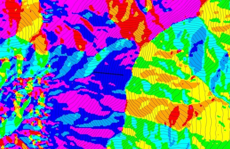
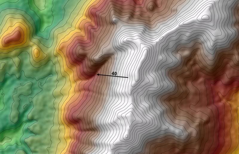
    To do this use a combination of contours, slope and aspect datasets derived from your surface.

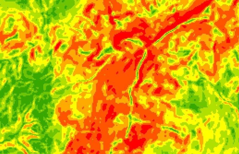
    Here is the Slope data, orange indicates slope of approximately 40 degrees. I'm going to insert an arrow in the orange area at the centre of the image.
    Arrow0.jpg


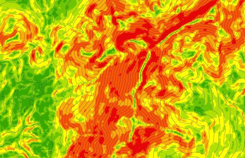
    Next I overlay the contours over the slope. The arrow will be approximately perpendicular to the contours.
    Arrow1.jpg


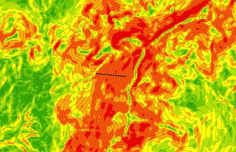
    So I use the New Line tool on the Draw Toolbar to place my line in the Orange area perpendicular to the contours.
    Arrow2.jpg

    Next I introduce the aspect layer. The blue colour indicates that the terrain is sloping from east to west. Therefore the "point" of the arrow will be on the leftmost end.
    Arrow3_2.jpg

    So I style the arrow accordingly and add the text.
    Arrow5_2.jpg

    lil*lady wrote: »
    Thirdly, (again I apologise for the rookie question), but try as I might I can't get my snapping to work, say I draw one road and then draw another beside it (e.g. in a Y fasion), as close as i zoom in they always seem to be like : \ / and won't connect. How I can get them to snap together for roads I've already done and roads that I will do in the future?

    Very rookie questions I know, but I'm really stuck and my supervisor is no use to me whatsoever.

    Tad bit clueless. Any help appreciated.

    Say you have a shapefile called Roads. On the Editor toolbar select Editor-Start Editing. Set Target to Roads. Now the Roads shapefile is editable. Any lines you digitise will be added to this shapefile. Now select Editor-Snapping. The Snap dialog opens. It will display all layers that you can snap to.

    If you select Vertex you will snap to any vertex on that layer. Edge will snap to anywhere along the features in that layer. End will only allow snapping to the endpoints of features in that layer.


  • Registered Users Posts: 3,803 ✭✭✭El Siglo


    YoureATowel that's excellent so it is, thanks a million! I would be absolutely fucked if it wasn't for your help. Seriously, you should be a mod on this forum.


  • Registered Users Posts: 3,803 ✭✭✭El Siglo


    I just gave it a "go" there now and it more or less works, I've a little playing around with it to do, i.e. get used to the different functions and making sure that I click the right layers etc... Thanks again YoureATowel, that's been a tremendous help so it has!:D


  • Advertisement
  • Closed Accounts Posts: 74 ✭✭lil*lady


    Thank you so much, I have to repeat what El Siglo said, thank you, it's very much appreciated.


Advertisement