Advertisement
Help Keep Boards Alive. Support us by going ad free today. See here: https://subscriptions.boards.ie/.
If we do not hit our goal we will be forced to close the site.

Current status: https://keepboardsalive.com/

Annual subs are best for most impact. If you are still undecided on going Ad Free - you can also donate using the Paypal Donate option. All contribution helps. Thank you.
https://www.boards.ie/group/1878-subscribers-forum

Private Group for paid up members of Boards.ie. Join the club.

BusConnects Dublin - Bus Network Changes Discussion

1529530531532533535»

Comments

  • Registered Users, Registered Users 2, Paid Member Posts: 19,074 ✭✭✭✭LXFlyer


    I wouldn’t be presuming that to be honest.

    The 68 will be replaced in the D-Spine phase by the 58 which will serve Bulfin Road but which will then go via Conyngham Road and the Quays.

    The 122 will be replaced on the southside at the same time by the 72 which will still serve the SCR between Rialto and Donore Avenue.

    They may retain something like the 68a along the SCR pending the introduction of the O to retain connectivity (if the O doesn’t happen in the meantime).


  • Registered Users, Registered Users 2 Posts: 216 ✭✭madnessnmayhem


    Regarding 122 what change that do? Where will it go to


  • Registered Users, Registered Users 2, Paid Member Posts: 19,074 ✭✭✭✭LXFlyer


    Route 72 (Drimnagh to East Wall) replacing southside half, and northside half replaced by route 48 (Ashington to City Centre)

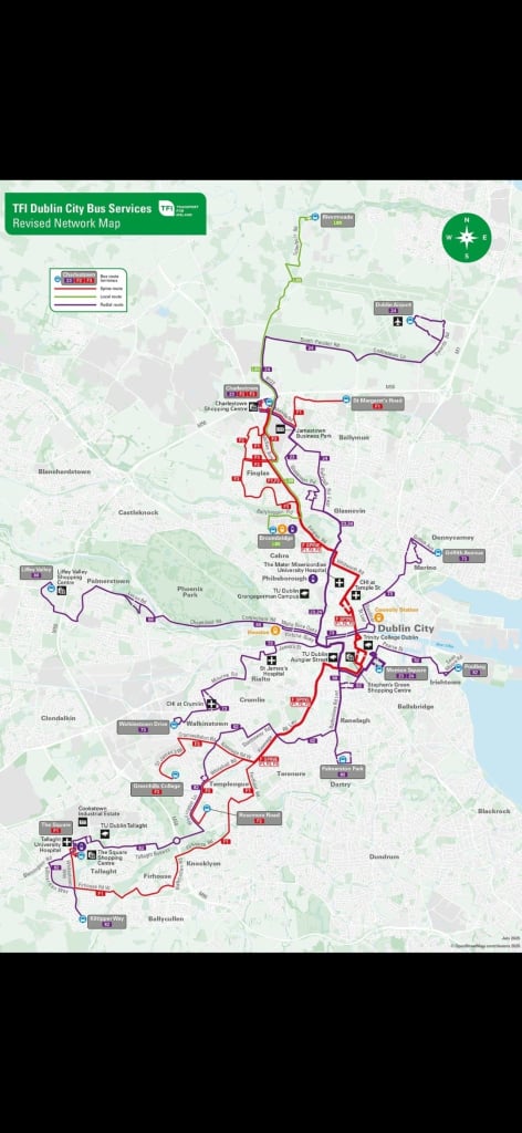
    The map is here

    https://busconnects.ie/wp-content/uploads/2024/06/A3-Big-Picture-Map-13.6.24.pdf

    You can follow the exact routes there starting at Crumlin Hospital or Ashington.


  • Registered Users, Registered Users 2 Posts: 813 ✭✭✭Jayuu


    Could anybody clarify a question I have on the D-Spine. Looking at the big picture map it would seem that for all intents and purposes the D2 is the 27 replacement and the D3 is the 15 replacement. These are the two buses I tend to use most regularly on my commute.

    My question is what is going to be the through city centre route for these routes? Are they being taken out of Dame Street in favour of using the quays as far as Christchurch and Winetavern Street? The big picture map doesn't really show exactly what is happening here.


  • Registered Users, Registered Users 2 Posts: 40 Arhanedus


    From my understanding, yes that is the plan. The F spine will go around Stephen's Green, and the D spine will go along the quays.


  • Advertisement
  • Registered Users, Registered Users 2, Paid Member Posts: 19,074 ✭✭✭✭LXFlyer


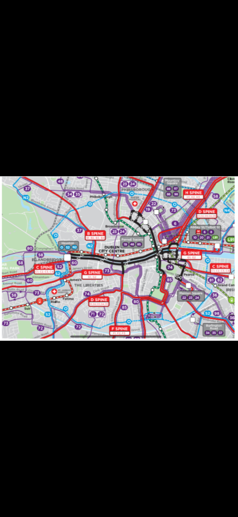
    Yes, the D-Spine routes will use the Quays and Winetavern Street. This is the map showing the adjusted city centre routings (taken from the final network consultation report).

    IMG_0256.png


  • Registered Users, Registered Users 2 Posts: 5,060 ✭✭✭thomasj


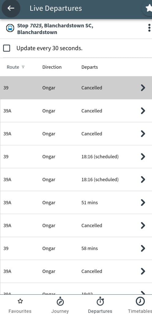
    Unmitigated disaster on the 39As all day. Long gaps between buses , cancellations and buses flying past full. Could have done with the VTs out today . Here's hoping it gets better with the B spine.


  • Registered Users, Registered Users 2 Posts: 4,107 ✭✭✭Polar101


    1000017285.png

    The buses are busy enough even without the cancellations.


  • Registered Users, Registered Users 2, Paid Member Posts: 19,074 ✭✭✭✭LXFlyer


    The parade for National Services Day through the city centre caused havoc with the bus service today - the knock on effects of it were still being felt hours later due to buses and/or staff being in the wrong locations.


  • Registered Users, Registered Users 2 Posts: 12,440 ✭✭✭✭tom1ie


    Any updates on getting ANPR up and running yet?


  • Advertisement
  • Registered Users, Registered Users 2, Paid Member Posts: 19,074 ✭✭✭✭LXFlyer


  • Registered Users, Registered Users 2 Posts: 260 ✭✭BusGuy


    Anyone know what Dublin Bus SG is used in the TFI ad? Can't figure out which one by the letters, also RIP old TFI livery


  • Registered Users, Registered Users 2 Posts: 9,802 ✭✭✭Midnight_EG


    Suffering jaysus


  • Registered Users, Registered Users 2 Posts: 12,440 ✭✭✭✭tom1ie


    Do we know who has responsibility for this? TII or does new legislation still need to be passed?


  • Registered Users, Registered Users 2 Posts: 691 ✭✭✭BP_RS3813


    Apologies if the question has been already answered but regarding the 27 and 15 replacement (D2 & D3 respectively), what exactly is changing other then the use of the Quays?

    Normally get 27 to dame St then walk rest of destination (up towards top of Camden St) or get 15 all the way up to upper Camden St.

    Thanks in advance


  • Registered Users, Registered Users 2 Posts: 293 ✭✭DaBluBoi


    27 will be fully replaced by D2, with some routing changes at Tallaght side.

    D1 and D3 will replace northern section of 15. Southern sections of D1 and D3 will follow that of 151 from city centre, with D1 fully replacing that section of 151 and D3 turning at Woodford to follow 13 routing. Current 15's southern section will become part of different bus route A1.

    So if you want to get to Camden at under new network, you'd have to get off at quays at Wellington Quay then walk to street, or transfer to A Spine that will stop at Camden


  • Registered Users, Registered Users 2, Paid Member Posts: 19,074 ✭✭✭✭LXFlyer


    Just to make the point that as a result of the project being phased, during the period between when the D-Spine phase happens until the A-Spine launch (both supposedly in 2026), the 14 & 15 will both become southside only routes, operating from the city centre to Dundrum and Knocklyon.


  • Registered Users, Registered Users 2 Posts: 451 ✭✭PlatformNine


    The 27 and D2 are very similar routes. From what I can tell they are almost identical with the most notable difference being it uses the Quays rather than Dame St and CG. However the last bit of the route west of The Square is different. The D2 extends all the way to Citywest like the 77A does, but its routing is more direct. The 27 and 77A coverage west of The Square is being covered between the D2 and D4, but it is not 1:1.

    However, the 15 is much more significant change. The northside route is being replaced by the D1 and D3, with the D1 being the 1:1 route and their combined frequency being what actually replaces the 15. However the southside route isn't being replaced by the D-spine, rather it is being replaced by the A1. Also for context the southside D1 and D3 are going to replace the 151 and 13. Then Northside A1 is replacing the 16, but terminates in Beaumont instead of continuing along Swords Rd.


  • Registered Users, Registered Users 2, Paid Member Posts: 19,074 ✭✭✭✭LXFlyer


    There is no legislation in place yet - no bill has even been published.

    When something happens, like everything else, it’ll be posted here but I’m not holding my breath.


  • Registered Users, Registered Users 2 Posts: 12,440 ✭✭✭✭tom1ie


    Jesus that is shocking.
    Without ANPR BC just won’t be as effective.


  • Advertisement
  • Registered Users, Registered Users 2 Posts: 153 ✭✭AX636


  • Registered Users, Registered Users 2 Posts: 451 ✭✭PlatformNine


    My wording was bad but my point was that A1 is replacing up the Beaumont Village portion of the 16. Also more generally I was trying to make the point that many of the routes aren't being replaced by a spine route 1 for 1, as that was part of the question I was responding to.

    The A2 is the more direct replacement for the 16 especially since the airport is the more important destination, but my comment was about the A1 so I didn't really feel the need to mention that. I would also point out that while the A2 is the closest to the 16, there are still some other notable changes. Most important is that it serves Rathmines instead of Harold's Cross.


  • Registered Users, Registered Users 2 Posts: 4,107 ✭✭✭Polar101


    Would be handy if they put some info about the delays in their real-time information systems. Like they did today when the Lucan festival impacted the C routes.


Advertisement