Advertisement
If you have a new account but are having problems posting or verifying your account, please email us on hello@boards.ie for help. Thanks :)
Hello all! Please ensure that you are posting a new thread or question in the appropriate forum. The Feedback forum is overwhelmed with questions that are having to be moved elsewhere. If you need help to verify your account contact hello@boards.ie
Winter 2011/2012
Options
Comments
-
Celtic Snow Man wrote: »I find it all to understand at the best of times and Piers new update does not make me any wiser.
Waat do you make of this forecast?
http://www.metcheck.com/V40/UK/FREE/14days.asp
Are they credible?
Mark Vogan says we are in for a big change around the 15th.
Someone asked Ken Ring his professional opinion of it and - allegedly - he said it thought it was cat (whatever that means). But that could be just a rumour - buy a husky just incase.0 -
What's the significance of that supposed to be??
It's Lucy Verasamy. Is that not significant enough on it's own?
Edit: Oh and Cronin's Yard (in Kerry) reported snow on Carrantoohill. There's also snow on Galtymore.
Both above 3000 ft so some freezing is to be expected with current temps.0 -
Keep heading south please
 0
0 -
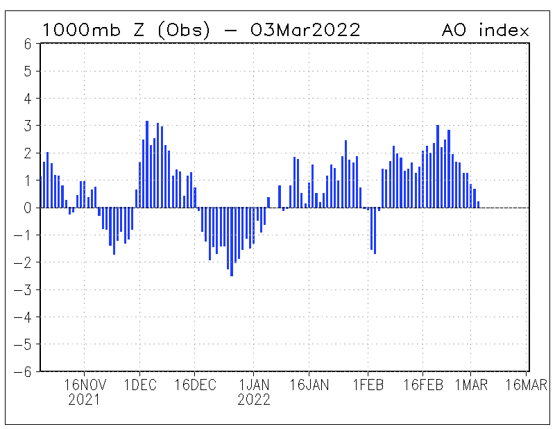
Ok, as fascinated noob, can I ask what this AO index is you keep going on about ?0
-
All you need to know for now is when its negative the Atlantic is quiet as pressure is high.similar happening around the artic and Greenland means our usual jet stream heads south bringing the usual Atlantic wet into France and south.opinion guy wrote: »Ok, as fascinated noob, can I ask what this AO index is you keep going on about ?
Our air feed then has to come from the icy north east or east.
Currently that nao is positive so we're seeing none of the above0 -
Advertisement
-
Celtic Snow Man wrote: »I find it all to understand at the best of times and Piers new update does not make me any wiser.
Waat do you make of this forecast?
http://www.metcheck.com/V40/UK/FREE/14days.asp
Are they credible?
Mark Vogan says we are in for a big change around the 15th.
'Sorry we couldn't find your location...'
Type in Dublin :
'javascript error' That website completely refuses to acknowledge Ireland exists. Even if you go to the Europe section and the list of all the countries in Europe Ireland isn't there :eek::eek::mad::rolleyes: 0
 -
All you need to know for now is when its negative the Atlantic is quiet as pressure is high.similar happening around the artic and Greenland means our usual jet stream heads south bringing the usual Atlantic wet into France and south.
Our air feed then has to come from the icy north east or east.
Currently that nao is positive so we're seeing none of the above
Ok for anyone else wondering the same and not wanting to be patronised
http://en.wikipedia.org/wiki/Arctic_oscillationThe Arctic oscillation (AO) or Northern Annular Mode/Northern Hemisphere Annular Mode (NAM) is an index (which varies over time with no particular periodicity) of the dominant pattern of non-seasonal sea-level pressure variations north of 20N latitude, and it is characterized by pressure anomalies of one sign in the Arctic with the opposite anomalies centered about 37-45N.[1] The AO is believed by climatologists to be causally related to, and thus partially predictive of, weather patterns in locations many thousands of miles away, including many of the major population centers of Europe and North America. NASA climatologist Dr. James Hansen explains the mechanism by which the AO affects weather at points so distant from the Arctic: "The degree to which Arctic air penetrates into middle latitudes is related to the AO index, which is defined by surface atmospheric pressure patterns. When the AO index is positive, surface pressure is low in the polar region. This helps the middle latitude jet stream to blow strongly and consistently from west to east, thus keeping cold Arctic air locked in the polar region. When the AO index is negative, there tends to be high pressure in the polar region, weaker zonal winds, and greater movement of frigid polar air into middle latitudes." This zonally symmetric seesaw between sea level pressures in polar and temperate latitudes was first identified by Edward Lorenz [2] and named in 1998 by David W.J. Thompson and John Michael Wallace.[3]
I'd better sit down for a few minutes....big words hurted my brain....0 -
Join Date:Posts: 6780
-
-
Just select Dublin from the county drop down list
Thanks, though not seeing a drop down county list now, there was a dropdown before which only had UK locations in it.
But I am now seeing a 14 day weather forecast for Dublin as default when I click on the link. So, they must have read my post and fixed whatever was wrong with it :pac:0 -
Advertisement
-
pistolpetes11 wrote: »Did you see the one in the FI thread , NAO on a downward trend on the 7,10,14 day chart
Even if NAO went very neg with that AO of a plus 4 or 5 we would NOT see a long cold spell however the AO is very high what could happen is the very cold air in the pole could tip like coins do in a slot machine and cause the cold air to come down south even with such a high AO index .
The ao in at record highs from what i can see
There is so much cold up in the pole it could come south its really strange the way it was neg -4 last year and now record high plus 4 . Shows to me the blocking is still very much in place this year even with sunspots beefing up.
What goes up must come down but it could take some months but lets hope vogan is correct he thinks around the 15th however basterdi now thinks it wont go very negative like last year but expects winter 2012 -13 and 2013 - 14 to be neg AO and NAO
So basterdi seems to be pointing to a normal irish winter this year
Vogan and Madden seem to still go with the idea of a huge dip in the AO and NAO however if this does not happen it will make there forecasts way off.
i think end of jan and into feb and march are best chance to see snow sometime in that time frame.0 -
Is it possible it could get stronger and they would have to revise their winter forecasts for a very different reason?
")
We can still get decent wintry episodes with a strong pv, via northern topplers, but if we want sustained cold we really need to see the pv split or at least be displaced through a warming event. I guess the last couple of years have raised the bar.0 -
Join Date:Posts: 6780
Even if NAO went very neg with that AO of a plus 4 or 5 we would NOT see a long cold spell however the AO is very high what could happen is the very cold air in the pole could tip like coins do in a slot machine and cause the cold air to come down south even with such a high AO index .
The ao in at record highs from what i can see
There is so much cold up in the pole it could come south its really strange the way it was neg -4 last year and now record high plus 4 . Shows to me the blocking is still very much in place this year even with sunspots beefing up.
What goes up must come down but it could take some months but lets hope vogan is correct he thinks around the 15th however basterdi now thinks it wont go very negative like last year but expects winter 2012 -13 and 2013 - 14 to be neg AO and NAO
So basterdi seems to be pointing to a normal irish winter this year
Vogan and Madden seem to still go with the idea of a huge dip in the AO and NAO however if this does not happen it will make there forecasts way off.
i think end of jan and into feb and march are best chance to see snow sometime in that time frame.
That was a mistype on my behalf its the AO that is forecasting to a negative trend. 0
0 -
FROM POSITIVE WEATHER SOLUTIONS
December – mild / chill contrasts, South drier, Northern snow chances
The start of winter is expected to present some contrasts for much of the British Isles. There are signals for some wet and unsettled weather over many western and a number of areas to the north. There is also strong evidence during the month for some chilly but mainly settled weather, with possibly severe overnight frost, along with persistent fog in low-lying localities. It is furthermore likely that wintry episodes will become established, with the potential for snow especially over areas of the North and East. Within this general circulation, some parts of northern and north-eastern Britain retain the best chance of experiencing a White Christmas. Temperatures will overall be on or slightly below average for the North, on or slightly above average for the South. Precipitation is likely to approach the long-term December norm, though some southern areas in particular may reflect notably drier than average values.
Ray Anthony
Chief Assistant Forecaster
Sunday November 27th 2011
FROM THE UKMO
UK Outlook for Monday 5 Dec 2011 to Wednesday 14 Dec 2011:
Remaining unsettled, with a continued risk of heavy showers and longer spells of rain along with high winds, particularly further west and northwest, as deep Atlantic depressions run close to, or over the UK. A risk of seeing snow over the higher ground of Scotland, even to lower levels for a time, and perhaps also hills further south for a time early next week. Temperatures generally below average, and feeling cold given the strength of the wind. There will also be a frost risk, especially in sheltered parts during quieter interludes overnight. Towards the end of the period, a gradual transition to somewhat quieter conditions is expected, especially across southern parts of the UK, but given quieter weather there will be an increased risk of widespread frost and fog here.
Updated: 1103 on Wed 30 Nov 2011
UK Outlook for Thursday 15 Dec 2011 to Thursday 29 Dec 2011:
The generally changeable westerly theme is likely to continue through the middle part of December, with spells of wet and windy weather mainly in the north, separated by some drier interludes mainly in the south. Generally, rainfall amounts are expected to be around or a bit above average, and western areas will on the whole see more rain than the east, although some wetter spells are likely for all parts. Sunshine hours should also be close to or slightly above normal, with eastern parts more likely to experience the best of the sun. Many places are likely to see near average temperatures for the time of year, with some milder and colder interludes and a continued risk of frost and hill snow, particularly through colder interludes.
Updated: 1132 on Wed 30 Nov 20110 -
has anyone seen metcheck for the next two weeks showing it getting colder and staying cold wit snow shows on east coast0
-
I love reading this thread.. you can almost feel the anticipation on here.
Now just to add to the crystal ball predictions.. made a post some time back that we would see some snow on Dec 11th... (random date of course)
here: http://www.boards.ie/vbulletin/showpost.php?p=74975536&postcount=14
Just kinda would like to say (based on no meteorological skills what so ever) this prediction still stands!! (please don't flame, at this stage it's just a bit of craic)... although looking at the long range charts over the last 3 days it is heading in the right direction ie. temps dropping.. but no real sign yet of snow (in my limited opinion).
Common we need some of the white stuff.. even though is is a pain to work outdoors in it, a week or two would be nice.0 -
ignore metcheck.
It's just an automated spouting of each gfs run.
So for example next week on it is what the latest gfs fantasy island chart shows.
Even within 48hrs it's usually wrong as the gfs varies from run to run.
Real forecasts are made by qualified meteorologists who use their intuition and a blend of all models.
Met check on the other hand is just an automated unofficial gfs display programme codding those not in the know for years.
It's owner was in prison at one point iirc for matters unrelated to weather and may still be inside.0 -
In my few years following the various weather threads, Post 2131 is the best I have seen. Fair ball to Roughies. I don't know how you did that, but pure class.
Up the Dubs, Let's hope for another East Coast blizzard (and rain for the rest). BTW, I acknowledge that is trolling.:D:D:D0 -
ignore metcheck.
It's just an automated spouting of each gfs run.
So for example next week on it is what the latest gfs fantasy island chart shows.
Even within 48hrs it's usually wrong as the gfs varies from run to run.
Real forecasts are made by qualified meteorologists who use their intuition and a blend of all models.
Met check on the other hand is just an automated unofficial gfs display programme codding those not in the know for years.
It's owner was in prison at one point iirc for matters unrelated to weather and may still be inside.
My spidey senses tell me blackius may be Black briar reborn....0 -
going by met eireann seems things are to get colder this weekend on wards but then again they are a state run dept could be all lies
") 0
0 -
Advertisement
-
ignore metcheck.
It's just an automated spouting of each gfs run.
So for example next week on it is what the latest gfs fantasy island chart shows.
Even within 48hrs it's usually wrong as the gfs varies from run to run.
Real forecasts are made by qualified meteorologists who use their intuition and a blend of all models.
Met check on the other hand is just an automated unofficial gfs display programme codding those not in the know for years.
It's owner was in prison at one point iirc for matters unrelated to weather and may still be inside.
Blackius, this type of comment is totally unnecessary and completely unrelated to weather, and I've seen several users get banned for similar. Also, the overall post refers only to one site (Metcheck), implying that it's the only one that delivers such a service, when in fact there are many. This could be viewed in a bad light, but as you may be new to the forum (though I have the feeling that baraca may not be a million miles away above), I will just ask that you stick to discussing weather in future.
That goes for everyone too (mrweatherman). 0 -
Brian Gaze, one of the most respected forecasters over on TWO (The Weather Outlook) has just issued his winter forecast for 2011/2012.
Again, its a LRF however it would now appear that more and more forecasters are now going for an average winter in the UK & Ireland.
Please bear in mind that the forecast is for the UK only however this would by extension, give some indication of his anticipated winter for Ireland.
The word "rain" is used plenty of times and I do not see the word "snow" employed much, except in relation to higher ground. If his forecast turns out to be correct, it could be time for the snow lovers of Ireland to mourn as we could be in for a dismal Atlantic mild fest However time will tell and I am still putting my faith in MT's prediction of a very cold January 2012............
D
Winter 2011: Close to average
Overview
A close to average winter is forecast with a weak bias towards slightly below normal temperatures over the three month period. Despite temperatures close to the average over the three month period as a whole, some colder spells are expected to bring a risk of some snow to all parts of the country, especially the north and east..
Temperature
Temperatures are expected to be close to or possibly just slightly below the long term average over the three month period. A deviation of between -0.7C to +0.3C from the 1971-2000 average is expected.
Precipitation
Over the three month period precipitation levels are generally expected to be close to average.
December
Temperature: Slightly below average
Precipitation: Above average
First half
The first half of the month is expected to bring a lot of unsettled and at times stormy weather to much of the UK. Temperatures will often be close to or just below average in the south, with colder conditions developing further north. Higher ground in northern regions could see significant snowfall, and at times snow could fall to lower levels in these areas, and over higher ground further south. Overnight frost developing at times.. Second half
The second half of the month may begin with a spell of quiet and cool weather as high pressure builds across the UK. This could bring a significant risk of frost and possibly fog, although bright conditions are likely at times. Later on a return to less settled weather is expected with rain affecting most of the UK again. The less settled weather should often be accompanied by higher temperatures, and southern areas may be rather mild at times. However, transitory colder conditions could continue to bring the possibility of wintry showers over higher ground, especially in the north.
January
Temperature: Close to average (Possibly slightly below)
Precipitation: Close to average
First half
The first half of the month is expected to begin rather unsettled conditions, with wet and windy weather and close to average temperatures for most of the country. Rainfall levels during the early part of the month may well be quite high across most of the UK, although drier conditions are expected at times, especially in the south east. Later in the period settled conditions may develop bringing an increasing risk of overnight frost.
Second half
The second half of the month is expected to bring colder conditions at times with frost developing increasingly widely. Some sleet or snow is likely, particularly in eastern regions. In the west and south west colder conditions are more likely to be interspersed by more frequent milder interludes which will bring a greater chance of rain and extend to eastern areas at times.
February
Temperature: Slightly above average (possibly close to)
Precipitation: Below average
First half
The first half of the month is expected to begin with rather cold and dry conditions, especially in eastern regions. Overnight frost is likely to be quite widespread and possibly sharp for a time. A change to less settled weather is expected to develop with temperatures returning to average values and outbreaks of rain affecting most of the UK. By the middle of the month dry conditions may return, with temperatures close to average in the west, but colder in the east with a risk of wintry showers and overnight frost at times.
Second half
The second half of the month may bring a good deal of dry to the south and south east, with temperatures probably rising above average. Less settled spells of weather are expected further north and west with rain and above average temperatures.
Forecast Issued 30/11/2011
0 -
I love reading this thread.. you can almost feel the anticipation on here.
Now just to add to the crystal ball predictions.. made a post some time back that we would see some snow on Dec 11th... (random date of course)
here: http://www.boards.ie/vbulletin/showpost.php?p=74975536&postcount=14
Just kinda would like to say (based on no meteorological skills what so ever) this prediction still stands!! (please don't flame, at this stage it's just a bit of craic)... although looking at the long range charts over the last 3 days it is heading in the right direction ie. temps dropping.. but no real sign yet of snow (in my limited opinion).
Common we need some of the white stuff.. even though is is a pain to work outdoors in it, a week or two would be nice.
:eek:
Tazio, himself said the same thing about the same date, also based on absolutely no science!! That must be more to it than this.... *rubs chin, camera pans out*:cool:
http://www.boards.ie/vbulletin/showpost.php?p=75710791&postcount=20180 -
Brian Gaze, one of the most respected forecasters over on TWO (The Weather Outlook) has just issued his winter forecast for 2011/2012.
Again, its a LRF however it would now appear that more and more forecasters are now going for an average winter in the UK & Ireland.
Please bear in mind that the forecast is for the UK only however this would by extension, give some indication of his anticipated winter for Ireland.
The word "rain" is used plenty of times and I do not see the word "snow" employed much, except in relation to higher ground. If his forecast turns out to be correct, it could be time for the snow lovers of Ireland to mourn as we could be in for a dismal Atlantic mild fest However time will tell and I am still putting my faith in MT's prediction of a very cold January 2012............
D
Winter 2011: Close to average
Overview
A close to average winter is forecast with a weak bias towards slightly below normal temperatures over the three month period. Despite temperatures close to the average over the three month period as a whole, some colder spells are expected to bring a risk of some snow to all parts of the country, especially the north and east..
Temperature
Temperatures are expected to be close to or possibly just slightly below the long term average over the three month period. A deviation of between -0.7C to +0.3C from the 1971-2000 average is expected.
Precipitation
Over the three month period precipitation levels are generally expected to be close to average.
December
Temperature: Slightly below average
Precipitation: Above average
First half
The first half of the month is expected to bring a lot of unsettled and at times stormy weather to much of the UK. Temperatures will often be close to or just below average in the south, with colder conditions developing further north. Higher ground in northern regions could see significant snowfall, and at times snow could fall to lower levels in these areas, and over higher ground further south. Overnight frost developing at times.. Second half
The second half of the month may begin with a spell of quiet and cool weather as high pressure builds across the UK. This could bring a significant risk of frost and possibly fog, although bright conditions are likely at times. Later on a return to less settled weather is expected with rain affecting most of the UK again. The less settled weather should often be accompanied by higher temperatures, and southern areas may be rather mild at times. However, transitory colder conditions could continue to bring the possibility of wintry showers over higher ground, especially in the north.
January
Temperature: Close to average (Possibly slightly below)
Precipitation: Close to average
First half
The first half of the month is expected to begin rather unsettled conditions, with wet and windy weather and close to average temperatures for most of the country. Rainfall levels during the early part of the month may well be quite high across most of the UK, although drier conditions are expected at times, especially in the south east. Later in the period settled conditions may develop bringing an increasing risk of overnight frost.
Second half
The second half of the month is expected to bring colder conditions at times with frost developing increasingly widely. Some sleet or snow is likely, particularly in eastern regions. In the west and south west colder conditions are more likely to be interspersed by more frequent milder interludes which will bring a greater chance of rain and extend to eastern areas at times.
February
Temperature: Slightly above average (possibly close to)
Precipitation: Below average
First half
The first half of the month is expected to begin with rather cold and dry conditions, especially in eastern regions. Overnight frost is likely to be quite widespread and possibly sharp for a time. A change to less settled weather is expected to develop with temperatures returning to average values and outbreaks of rain affecting most of the UK. By the middle of the month dry conditions may return, with temperatures close to average in the west, but colder in the east with a risk of wintry showers and overnight frost at times.
Second half
The second half of the month may bring a good deal of dry to the south and south east, with temperatures probably rising above average. Less settled spells of weather are expected further north and west with rain and above average temperatures.
Forecast Issued 30/11/2011 0
0 -
-
well a little hope for coldlovers after reading this bit of bad news :P i looked around for brian gazes winter forecast for last year and found only one site that had his forecast for last winter,maybe he took it down or something because i couldnt find it on the weather outlooks site.anyway brian gaze got it quite wrong last year saying worst of cold would be in 2nd half of january and first half of february which was very wrong as they were very warm and said the winter would be not as bad as 09/10 with shorther less prolonged cold spells ...so thats good news hopefully hes wrong again:D so he was quite off the mark...didnt even forecast the very early november snow! his forecast---- http://www.kitingireland.com/forum/index.php?topic=4782.0Brian Gaze, one of the most respected forecasters over on TWO (The Weather Outlook) has just issued his winter forecast for 2011/2012.
Again, its a LRF however it would now appear that more and more forecasters are now going for an average winter in the UK & Ireland.
Please bear in mind that the forecast is for the UK only however this would by extension, give some indication of his anticipated winter for Ireland.
The word "rain" is used plenty of times and I do not see the word "snow" employed much, except in relation to higher ground. If his forecast turns out to be correct, it could be time for the snow lovers of Ireland to mourn as we could be in for a dismal Atlantic mild fest However time will tell and I am still putting my faith in MT's prediction of a very cold January 2012............
D
Winter 2011: Close to average
Overview
A close to average winter is forecast with a weak bias towards slightly below normal temperatures over the three month period. Despite temperatures close to the average over the three month period as a whole, some colder spells are expected to bring a risk of some snow to all parts of the country, especially the north and east..
Temperature
Temperatures are expected to be close to or possibly just slightly below the long term average over the three month period. A deviation of between -0.7C to +0.3C from the 1971-2000 average is expected.
Precipitation
Over the three month period precipitation levels are generally expected to be close to average.
December
Temperature: Slightly below average
Precipitation: Above average
First half
The first half of the month is expected to bring a lot of unsettled and at times stormy weather to much of the UK. Temperatures will often be close to or just below average in the south, with colder conditions developing further north. Higher ground in northern regions could see significant snowfall, and at times snow could fall to lower levels in these areas, and over higher ground further south. Overnight frost developing at times.. Second half
The second half of the month may begin with a spell of quiet and cool weather as high pressure builds across the UK. This could bring a significant risk of frost and possibly fog, although bright conditions are likely at times. Later on a return to less settled weather is expected with rain affecting most of the UK again. The less settled weather should often be accompanied by higher temperatures, and southern areas may be rather mild at times. However, transitory colder conditions could continue to bring the possibility of wintry showers over higher ground, especially in the north.
January
Temperature: Close to average (Possibly slightly below)
Precipitation: Close to average
First half
The first half of the month is expected to begin rather unsettled conditions, with wet and windy weather and close to average temperatures for most of the country. Rainfall levels during the early part of the month may well be quite high across most of the UK, although drier conditions are expected at times, especially in the south east. Later in the period settled conditions may develop bringing an increasing risk of overnight frost.
Second half
The second half of the month is expected to bring colder conditions at times with frost developing increasingly widely. Some sleet or snow is likely, particularly in eastern regions. In the west and south west colder conditions are more likely to be interspersed by more frequent milder interludes which will bring a greater chance of rain and extend to eastern areas at times.
February
Temperature: Slightly above average (possibly close to)
Precipitation: Below average
First half
The first half of the month is expected to begin with rather cold and dry conditions, especially in eastern regions. Overnight frost is likely to be quite widespread and possibly sharp for a time. A change to less settled weather is expected to develop with temperatures returning to average values and outbreaks of rain affecting most of the UK. By the middle of the month dry conditions may return, with temperatures close to average in the west, but colder in the east with a risk of wintry showers and overnight frost at times.
Second half
The second half of the month may bring a good deal of dry to the south and south east, with temperatures probably rising above average. Less settled spells of weather are expected further north and west with rain and above average temperatures.
Forecast Issued 30/11/2011
what would you guys rate his winter forecast for last year? i'd give 3/10 purely for the fact he said itd be cold..he got the timing very wrong.0 -
well a little hope for coldlovers after reading this bit of bad news :P i looked around for brian gazes winter forecast for last year and found only one site that had his forecast for last winter,maybe he took it down or something because i couldnt find it on the weather outlooks site.anyway brian gaze got it quite wrong last year saying worst of cold would be in 2nd half of january and first half of february which was very wrong as they were very warm and said the winter would be not as bad as 09/10 with shorther less prolonged cold spells ...so thats good news hopefully hes wrong again:D so he was quite off the mark...didnt even forecast the very early november snow! his forecast---- http://www.kitingireland.com/forum/index.php?topic=4782.0
what would you guys rate his winter forecast for last year? i'd give 3/10 purely for the fact he said itd be cold..he got the timing very wrong.
I wouldn’t worry too much about it, It’s a safe forecast really, he doesn’t put his neck on the line, I wouldn’t say most are going for an average as you posted a list of lrf's and most were going for cold, The met are going for an average, and 2 others I can think off, the rest are cold. We will wait till March to see who was right and wrong.0 -
Sitting with my Girlfriend here having tea, doing our work and listening to the howling wind and rain bashing our balcony door. She just turned to me and said... didn't this happen before we got a cold snap and snow last year? For the life of me I could not remember... and still can't! Can anyone say that this accurate? She believes the snow is coming. She generally gets it right... a womans instinct!:cool:0
-
Well... I hope she gets it right! HA! Any other enlightening musings from Piers Corbyn? I read some of the comments on his twitter and on weatheraction.com. Some frustrated folk on there. Perhaps he got jumped the gun a bit. The storm surge he spoke about for Oct didn't come to pass and now no snow or 'exceptionally' cold from 27th of November...although it has gotten colder. If only the AO would remain on a negative trend...0
-
Advertisement
-
My cat wrote the word 'snow' in the condenstation on our sitting room window with her paw earlier this evening. She looked at me with a wise glint in her eye, as if to suggest she knows its coming.
I didn't even know cats could write, let alone predict weather.0


This discussion has been closed.
Advertisement