Advertisement
If you have a new account but are having problems posting or verifying your account, please email us on hello@boards.ie for help. Thanks :)
Hello all! Please ensure that you are posting a new thread or question in the appropriate forum. The Feedback forum is overwhelmed with questions that are having to be moved elsewhere. If you need help to verify your account contact hello@boards.ie

M8 - Mitchelstown to Fermoy

Options
13468918

Comments

  • Registered Users Posts: 8,779 ✭✭✭Carawaystick


    corktina wrote: »
    no..it ends with both at prsent...the first slip being the eventual permanaent one I guess.

    but there's a load of work ripping up one of the slips and tying in the new route.
    any other sensible tie in's I've seen always extend the main line and use one slip, Kilbeggan, Tyrrelspass on the M6, South of Dundalk on the M1, Mithcelstown N on the M8,


  • Closed Accounts Posts: 2,468 ✭✭✭BluntGuy


    Fermoy Bypass is pretty much the most awkward tie-in job I've ever seen.

    Well apart from the Cashel Bypass, that was painful, they had to turn an at-grade roundabout into a GSJ at both ends.

    But still, they could've made this one easier for themselves I have to admit...


  • Closed Accounts Posts: 6,093 ✭✭✭Amtmann


    Furet, have you got any funny looks or hassle for taking videos or photos from the contractors or are they all friendly enough or apatethic to you? They are great stuff to have.

    While I was filming the three videos I posted here I don't think the builders even noticed me to be honest...they just seemed really stuck into the job they were doing. The drivers are a different story. The guys driving the dump trucks would usually give me a beep or wave a salute as they drive along. I get the impression they love their jobs! Last July I'd often meet a few guys working late at around 8pm and they'd often stop and chat. (People living near road construction sites usually go for walks or cycles on the mainline in the evening after work has stopped.)


  • Closed Accounts Posts: 6,093 ✭✭✭Amtmann


    Am I correct in thinking the Fermoy bypass ended with not at an exit slip to the left of the main line but cut across the main line and ended at the right of the main line as you go northbound?

    You can see how the Fermoy Bypass ends in this video...skip forward to about 6.45. In the video I am travelling northbound towards Dublin.


  • Closed Accounts Posts: 3,082 ✭✭✭Chris_533976


    If you think about it it really was a stupid way to terminate a scheme when they KNOW DAMN WELL that Mitch - Fermoy was gonna be built.

    A roundabout is one thing, its safer than just terminating into the old road (speed reasons), but the crap at Moorepark is just crazy.


  • Advertisement
  • Closed Accounts Posts: 6,093 ✭✭✭Amtmann


    If you think about it it really was a stupid way to terminate a scheme when they KNOW DAMN WELL that Mitch - Fermoy was gonna be built.

    A roundabout is one thing, its safer than just terminating into the old road (speed reasons), but the crap at Moorepark is just crazy.

    True. I think the reason why Cashel to Mitchelstown ends so nicely at Carrigane/Kilbeheny is because the grade seperated junction 12 was actually built as part of the M-F scheme - and because Roadbridge was/is the contractor for both projects.


  • Banned (with Prison Access) Posts: 13,018 ✭✭✭✭jank


    Sorry to bring this up here but what is the latest with the Culahill - Portlaoise section? Last I heard they stopped work on the thing.


  • Closed Accounts Posts: 6,093 ✭✭✭Amtmann


    jank wrote: »
    Sorry to bring this up here but what is the latest with the Culahill - Portlaoise section? Last I heard they stopped work on the thing.

    See: http://www.boards.ie/vbulletin/showthread.php?t=2055344405&page=5 post #65.


  • Closed Accounts Posts: 6,093 ✭✭✭Amtmann


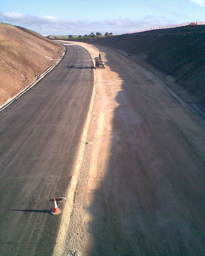
    Major tie-in works at Carrigane (junction 12 with the C-M scheme) today.

    3275047230_c1eaef8e64_o.jpg
    The view south.

    3275046560_3dffd94721_o.jpg
    The view north.

    Sorry for the poor image quality; the photos were taken with a mobile phone.

    Elsewhere along the scheme landscaping works are making excellent headway, the nothern end of the scheme continues to receive the first two asphalt layers (this aspect should be complete by the end of next week, weather permitting), and the median is being installed along it too.
    Major works at the Fermoy Bypass tie-in, but a photograph wouldn't reveal very much because there's no place to take a decent one of the earthworks from.

    At this stage, I believe we must be looking at an opening sometime in late April.


  • Registered Users Posts: 2,091 ✭✭✭marmurr1916


    Furet wrote: »
    Elsewhere along the scheme landscaping works are making excellent headway, the nothern end of the scheme continues to receive the first two asphalt layers (this aspect should be complete by the end of next week, weather permitting), and the median is being installed along it too.

    Major works at the Fermoy Bypass tie-in, but a photograph wouldn't reveal very much because there's no place to take a decent one of the earthworks from.

    At this stage, I believe we must be looking at an opening sometime in late April.

    Great pics as usual. Assuming it's a Wednesday opening (lighter traffic) then Wednesday 29th seems the most likely date.

    That's less than 10 weeks away!


  • Advertisement
  • Closed Accounts Posts: 6,093 ✭✭✭Amtmann


    Great pics as usual. Assuming it's a Wednesday opening (lighter traffic) then Wednesday 29th seems the most likely date.

    That's less than 10 weeks away!

    I think the 24th or 27th of April; or, alternatively, either the 1st, 4th or 8th of May.

    They will start to lay the final surface in March...I don't know how long that'll take, but I suspect it'll be done by mid April, possibly sooner. Once that's done, they'll only need two or three days to stud and line the road. The Fermoy Bypass tie-in should be done by mid-April too...that's why I'm optimistic for that month.

    Landscaping works are being done at the moment, but these are about a fortnight to three weeks behind the pavement construction works, so these will also be one of the last things to finish up. The batching plant will have to be dismantled and the area landscaped. In addition there's a massive pile of earth and rock behind Kilworth Army camp (it's visible from the N8) close to where the service area ought to be constructed that'll have to be cleared away.

    The very first post on this thread, which I put up last July, predicted a March/April opening. That estimate was based on a conversation I had with a builder around the time the C-M scheme opened. It looks like the chap wasn't too far off the mark in fairness to him.


  • Closed Accounts Posts: 3,082 ✭✭✭Chris_533976


    Good grief they're doing that tie-in quick.

    Puts M7/M8 to absolute shame this scheme does :(


  • Closed Accounts Posts: 1,044 ✭✭✭AugustusMaximus


    Good grief they're doing that tie-in quick.

    Puts M7/M8 to absolute shame this scheme does :(

    Its a disgrace that the scheme which will prob finish the M8 and indeed the M7 is going at such a snailpace. And considering the traffic jams in both Durrow and Abbeyleix it is far more necessary than this scheme.

    Nice to see this scheme to get done so fast though.


  • Closed Accounts Posts: 6,093 ✭✭✭Amtmann


    I agree that strategically the M7/M8 PPP is much more important than the M-F scheme for a number of reasons, not least of which is traffic alleviation for Mountrath, Durrow and Abbeyleix.

    However, it's important to point out that the M-F scheme, although very short at only 16km, will actually save motorists substantially more time per kilometre than either the C-C or C-M schemes. It will definitely knock 11 minutes off the journey - at ALL times. And from a safety perspective, it will remove a stretch where fatalities and injuries occur annually.

    Anyway, the tie-in with the C-M scheme was substantially completed today:

    3277004004_7790b0d089_b.jpg

    3277001358_fdf623a49e_b.jpg


  • Closed Accounts Posts: 3,082 ✭✭✭Chris_533976


    Great pics as always :D


  • Registered Users Posts: 2,091 ✭✭✭marmurr1916


    Furet wrote: »
    Anyway, the tie-in with the C-M scheme was substantially completed today

    That's incredibly fast work.

    Do you know if the initial surfacing from Carrigane to near the tie-in with the northern end of the Fermoy bypass is now substantially complete?

    I assume that it is and that all that's left to do on most of the route is to add the final surface layer(s), build the barrier, line/mark the road, erect signs and tidy up the verges and embankments?

    It's also very clear from the top picture that the landscaping budget has been cut drastically.

    Surely it wouldn't cost too much to get rid of those ugly weeds on the embankments and plant a few shrubs?


  • Closed Accounts Posts: 6,093 ✭✭✭Amtmann


    Do you know if the initial surfacing from Carrigane to near the tie-in with the northern end of the Fermoy bypass is now substantially complete?

    It is. It's asphalt from here on in. Three layers of this go down; I would say the first 2 layers along the entire length of the scheme are 80% laid.
    I assume that it is and that all that's left to do on most of the route is to add the final surface layer(s), build the barrier, line/mark the road, erect signs and tidy up the verges and embankments?

    Pretty much, and the barrier is 60% installed already along the entire scheme. Sign foundations appear to be starting too. The banks and verges are being tidied at the moment
    It's also very clear from the top picture that the landscaping budget has been cut drastically. Surely it wouldn't cost too much to get rid of those ugly weeds on the embankments and plant a few shrubs?

    :D

    Now do you all see what I'm grumbling about? In fairness, the M-F scheme will be far better landscaped than the C-M scheme. They will tidy the banks of the M-F project in that first picture; just give them three or four weeks.


  • Closed Accounts Posts: 2,468 ✭✭✭BluntGuy


    Furet wrote: »
    Now do you all see what I'm grumbling about? In fairness, the M-F scheme will be far better landscaped than the C-M scheme. They will tidy the banks of the M-F project in that first picture; just give them three or four weeks.

    The NRA still seem to be labouring under the deluded notion that animals will graze the motorway verges and give them a pastoral look. Naturally this is not the case, so instead of looking like nice pastoral fields, they look absolutely horrible.

    The wide-median section near Cahir is the most hideous-looking median I've ever seen.

    C-C is somewhat presentable, though nothing special, and M-F looks to be inbetween the two. I miss the days when roads were actually built with thought put into landscaping.

    What's worse is that lovely scenery is ruined by the shoddiness of the landscaping works. The embanked section of M8 just after Carrigane travelling northbound has one of the most beautiful views of the Galtees you'll ever see. Sadly though, it is somewhat recked by the weedy looking flora on the verge.


  • Closed Accounts Posts: 6,093 ✭✭✭Amtmann


    BluntGuy wrote: »
    The embanked section of M8 just after Carrigane travelling northbound has one of the most beautiful views of the Galtees you'll ever see. Sadly though, it is somewhat recked by the weedy looking flora on the verge.

    The M-F section will offer some pretty awesome views too between junction 13 and 12 when it's opened.

    Now, on the subject of service areas: one of these will be situated at some point along the M-F scheme, technically anywhere between j12 and j14, but most likely between j13 and j14. I've a feeling it'll go in right behind Kilworth Army Camp.


  • Closed Accounts Posts: 2,468 ✭✭✭BluntGuy


    Furet wrote: »
    The M-F section will offer some pretty awesome views too between junction 13 and 12 when it's opened.

    Now, on the subject of service areas: one of these will be situated at some point along the M-F scheme, technically anywhere between j12 and j14, but most likely between j13 and j14. I've a feeling it'll go in right behind Kilworth Army Camp.

    I really don't know. They say Kilworth, but let us not forget that the other M8 MSA was originally to be situated between Cashel and Cahir.

    Kilworth seems like the right place and it divides the M8/M7 to Portlaoise up quite nicely in terms of MSA coverage.

    I just hope they come up with something different for this design though. I've looked through all the EIS plans, and the designs for every MSA seem to be EXACTLY the same. Where's the thought and originality? A bit of creative thinking wouldn't go amiss. Yes, the main point of an MSA is to be... well a service area. But I can't help but feel that we're wasting an oppurtunity to add something unique to our motorway network.

    Anyway, yes, I think Kilworth or certainly between J13 and J14 anyway. Between J13 and J12 doesn't feel suitable. First of all because the junctions are quite close (< 7km I imagine), and sticking another one in middle clutters things. Second, it won't capture any of the Mitchelstown traffic heading to and from Cork(because they'll almost certainly use the Mitch South junction (J13 Southbound).


  • Advertisement
  • Closed Accounts Posts: 2,468 ✭✭✭BluntGuy


    BluntGuy wrote: »
    After that, I'm pretty lost, but hopefully in two-three weeks time we'll have an idea of what they're doing.

    Forget to ask you Furet. I know taking pictures wasn't suitable, but do you know what the current "schedule" so-to-speak, for the Fermoy Bypass tie-in is? What work has been carried out, and what would you say they'll be doing next? I haven't been up there myself.


  • Closed Accounts Posts: 6,093 ✭✭✭Amtmann


    Between J12 and 13 doesn't seem to suit topographically either, if flatness is a desirable quality. In fact the only flat area is from J13 to the Army Base, and even parts of that aren't suitable, as per here:

    3276714629_aae483d25c.jpg

    South of the army camp, skirting around the back of Corbett Court say, a steep ravine makes an SA awkward to construct, and of course the closer you get to J14 the closer you get to that demesne landscape and river, which are ecologically and archaeologically precious. So, I'd say the army base it'll have to be. The EIS should be released in March, right?


  • Closed Accounts Posts: 6,093 ✭✭✭Amtmann


    BluntGuy wrote: »
    Forget to ask you Furet. I know taking pictures wasn't suitable, but do you know what the current "schedule" so-to-speak, for the Fermoy Bypass tie-in is? What work has been carried out, and what would you say they'll be doing next? I haven't been up there myself.

    It's difficult to describe. Most of the work these past two weeks has taken place at the far left of the southbound carriageway as you stand on the J14 overbridge. They seem to be adding an extra few metres of carriageway over there, widening the road. They had one of those mega JCB-mounted jack-hammers there today shattering the road and ripping great chunks out of it. They've also installed a foundation for one of those cantilevers to signify exit 14 northbound on the Fermoy Bypass itself. It seems they are going to have to slice a big chunk out of the bypass after all, and not only that, but widen it too. The way I'm describing it makes it sound confusing; but there's no place to take a photo from at the moment that would clarify things to any degree.


  • Closed Accounts Posts: 2,468 ✭✭✭BluntGuy


    I think I know what you're saying and I'll probably pass up there next week or the week after to see the progress for myself.
    They seem to be adding an extra few metres of carriageway over there, widening the road.

    Yes, I thought they would. The existing set-up doesn't have enough space for a decent on-slip and two mainline lanes.
    They had one of those mega JCB-mounted jack-hammers there today shattering the road and ripping great chunks out of it.

    So basically they're just chunking out bits of the Fermoy Bypass.
    They've also installed a foundation for one of those cantilevers to signify exit 14 northbound on the Fermoy Bypass itself.

    I'm hoping the Fermoy Bypass's signage will be brought in line with the rest of the M8 signage. Most of it is pretty simple. They need to cover the "(N8)" patches with a blue patch (no need for a whole new sign). Cantilevers are needed at the exits and new gore signs are required. That's it really. If they want, they can add the 2km ADS.

    EDIT: Yes, the EIS will be published in March hopefully. They told me February for Cashel, so I'll take their word for Kilworth as well. However, I expect M7 Nenagh before that.


  • Moderators, Business & Finance Moderators, Motoring & Transport Moderators, Society & Culture Moderators Posts: 68,015 Mod ✭✭✭✭L1011


    BluntGuy wrote: »

    I just hope they come up with something different for this design though. I've looked through all the EIS plans, and the designs for every MSA seem to be EXACTLY the same. Where's the thought and originality? A bit of creative thinking wouldn't go amiss. Yes, the main point of an MSA is to be... well a service area. But I can't help but feel that we're wasting an oppurtunity to add something unique to our motorway network.

    There is something to be said for bland uniformity - its easy to maintain. While it'd be nice to have equivalents of the Pennine Tower, there is a reason that isn't open to the public any more...


  • Closed Accounts Posts: 2,468 ✭✭✭BluntGuy


    I thought I'd give Furet a break and provide this week's weekly update (so-to-speak) myself (yes - includes photos!). ;)

    There isn't really all that much to say, but I'll say it anyway.

    Fermoy-Mitchelstown Southbound Tie-In

    The southbound carriageway was closed earlier today between J11 and J12 (presumably to allow tie-in work to take place).

    I do have pictures, but they're not all that revealing. If you want to see them, I'll upload them to SABRE later on (possibly tommorow).

    Fermoy-Mitchelstown Mainline

    The usual progress. Not much to say here except it's advancing rapidly as Furet says. There is a 3 - 5 metre missing chunk in the median between J13 and J14. I presume it'll be filled in with those metal barriers.

    Fermoy-Mitchelstown Northbound Tie-In

    Still chaos. As Furet said, the old signage has been taken down (as you'll see in the photos) and the tie-in looks like chaos still. The new carriageway earthworks seem to have substantially reached completion though, so I expect to see some pavement foundation going down within the next week or two.

    Old Signage has been removed:

    3298567946_f164315fb2.jpg


    Tie-In Chaos (looking northbound):

    3298575732_5424606c9e.jpg


  • Closed Accounts Posts: 6,093 ✭✭✭Amtmann


    BluntGuy wrote: »
    The southbound carriageway was closed earlier today between J11 and J12 (presumably to allow tie-in work to take place).

    I'd be inclined to think it was closed so they could fix the SUBSIDENCE (:mad:) about 1km north of Carrigane.


  • Closed Accounts Posts: 2,468 ✭✭✭BluntGuy


    Subsidence?

    Could you explain exactly what happened? Did the road surface shift or something, or are you referring to the bumpy mess it already is.


  • Closed Accounts Posts: 6,093 ✭✭✭Amtmann


    BluntGuy wrote: »
    Subsidence?

    Could you explain exactly what happened? Did the road surface shift or something, or are you referring to the bumpy mess it already is.

    I've tried to describe it on the M8 thread in infrastructure. It's a new problem.


  • Advertisement
  • Registered Users Posts: 1,002 ✭✭✭ipodrocker


    Furet and BluntGuy thanks for all the updates its great to see the progress of the tie-in.


This discussion has been closed.
Advertisement