Advertisement
If you have a new account but are having problems posting or verifying your account, please email us on [email protected] for help. Thanks :)
Hello All, This is just a friendly reminder to read the Forum Charter where you wish to post before posting in it. :)
Hi all, The AutoSave Draft feature is now disabled across the site. The decision to disable the feature was made via a poll last year. The delay in putting it in place was due to a bug/update issue. This should serve as a reminder to manually save your drafts if you wish to keep them. Thanks, The Boards Team.
Hello all! This is just a quick reminder to ensure that you are posting a new thread or question in the appropriate forum. The Feedback forum is overwhelmed with questions that are having to be moved elsewhere.

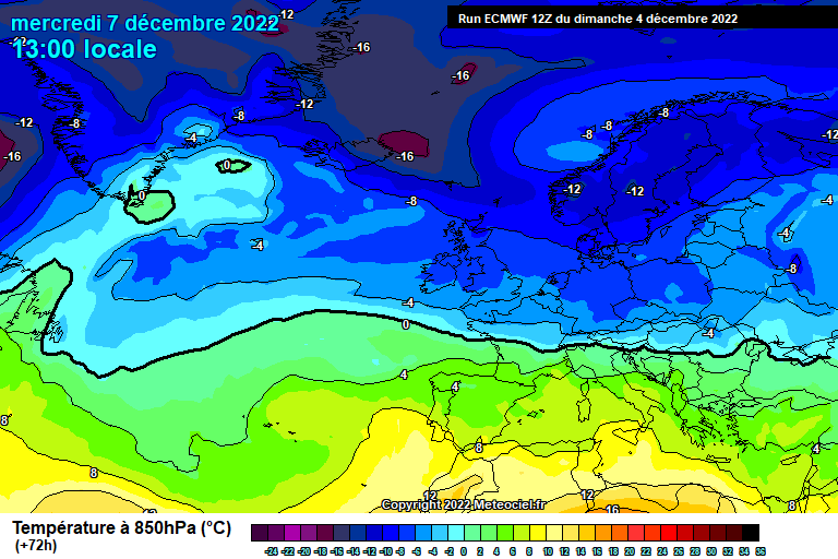
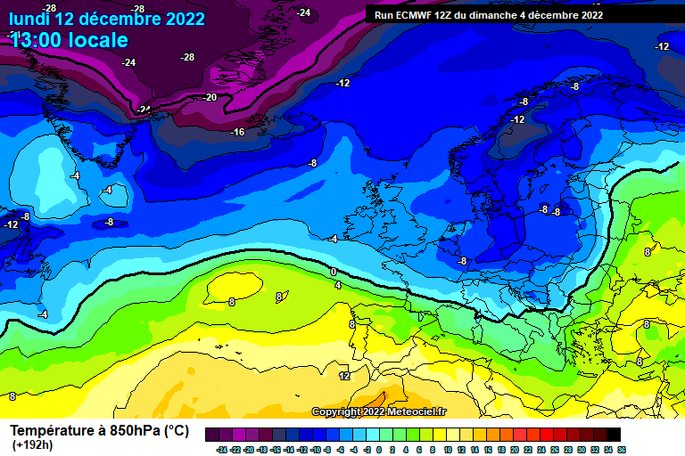
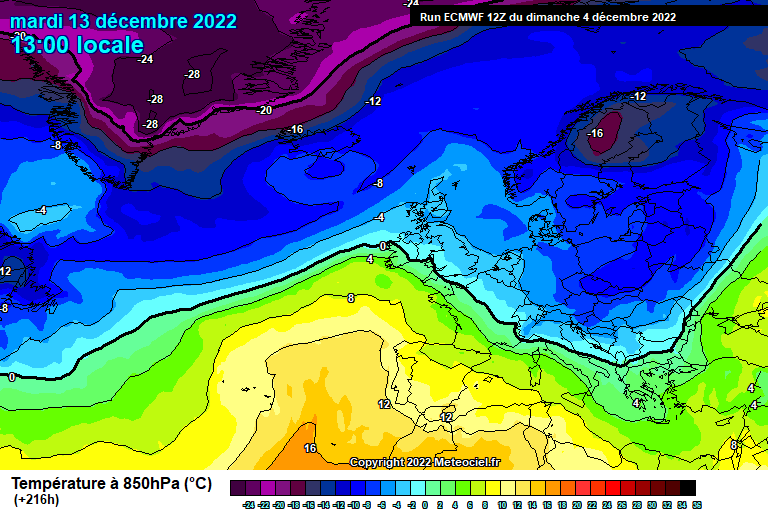
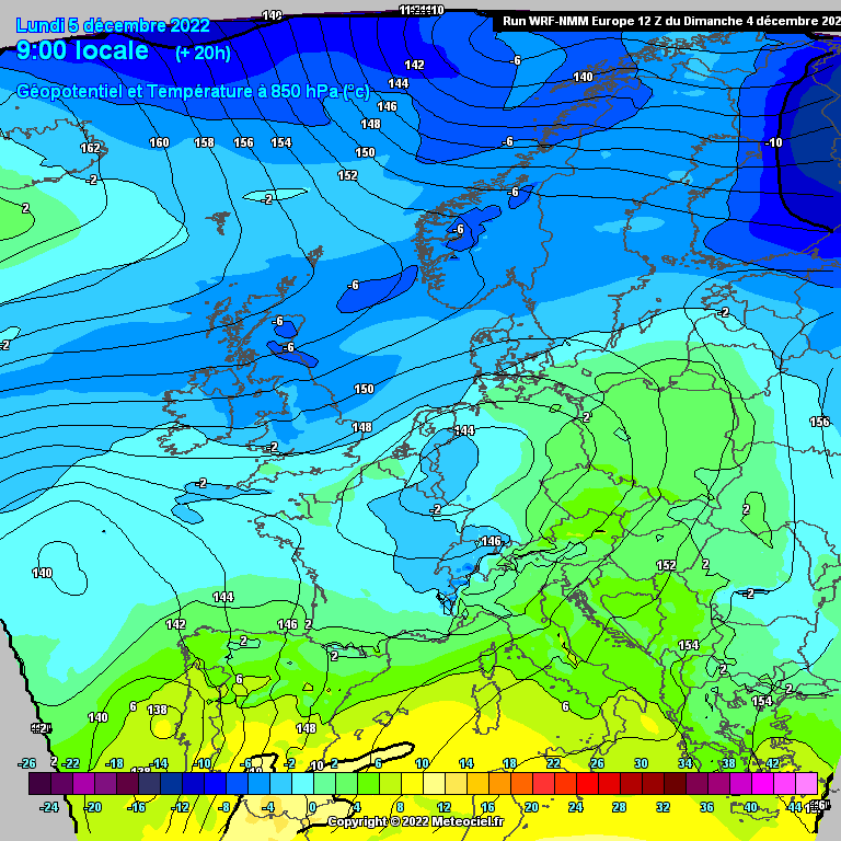
Colder this week, some wintry/snow showers, widespread frost and ice.

  • 04-12-2022 6:03pm
    #1
    Registered Users Posts: 22,222 ✭✭✭✭ Kermit.de.frog


    Forecast chat thread for this, hopefully, event

    Ok I'll give it a go! It's a marginal situation, a lot of uncertainty and specifics would be a bit too unwise right now but lets get the ball rolling!

    What is for sure...

    Main points:

    • Turning colder from the north
    • Night time frost and icy patches
    • Some wintry falls and some snow
    • Could be beginning of longer period of much colder weather

    Possible warning level - Snow - Yellow

    From Tuesday night on turning notably colder with some wintry showers especially near windward coasts in the north and northwest and, at times, along Atlantic coasts and the southwest. Later, toward the weekend, the higher risk may extend to the east coast.

    In terms of snow potential - over 200 meters is a good bet but to lower levels at times too with a more organised band of showers moving south some time Thursday night/Friday morning which could leave a couple of centimeters just about anywhere.

    Mostly at low levels the showers will be a messy mix of rain/sleet/snow but inland spots always the better chance of seeing snowfall.

    Temperatures:

    From Wednesday onward daytime temperatures really struggle above freezing to around 2 or 3c max away from immediate windward coasts of the north/northwest/west/southwest but anywhere snow accumulates staying around freezing for daylight hours. On windward coasts 4 - 6c max.

    Night time minima from Wednesday onward inland, particularly the southeast, down to -3 or -4c but that depends on cloud cover as well as there will be showers moving through at times. Between 0 and -2c will be the normal widespread night time minima.

    Frost and ice will be slow to clear during daylight hours and in sheltered spots may see out the days in the second half of the week.

    There is a lot of uncertainty because of the synoptic situation later next week when we will be near centers of low pressure from time to time making wind direction quite variable and this impacts depending on the direction. It will stay very cold throughout with wintry showers but for snow it's really narrow margins for the second half of the week for low elevations.

    The big question right now is whether this is a blip or part of a much longer period of deeper cold weather maybe the following week. The synoptic situation is unusual and there every chance of sharper cold weather later on.

    We need to wait and see how things unfold but I'll be updating the thread as things become clearer.

    Apologies can't be more accurate just yet but it will be exciting watching it developing or crash all the same! 😀


    Post edited by Meteorite58 on


«13456785

Comments

  • Registered Users Posts: 470 ✭✭ Apothic_Red


    Needs work on the title


  • Registered Users Posts: 22,222 ✭✭✭✭ Kermit.de.frog


  • Registered Users Posts: 49 Sleepy Joseph


    Will this be like 2010 or 2018?


  • Advertisement
  • Registered Users Posts: 4,453 ✭✭✭ SpitfireIV


    Are you driving from Inisturk to Dublin airport? If so make sure it's not one of the days you have to put the wheelie bins out!


  • Registered Users Posts: 23,699 ✭✭✭✭ lawred2


    What I've mostly been reading is for cold muck.. I'm not really expecting any snowscapes. Not where I am anyway in North Dublin.


  • Registered Users Posts: 23,699 ✭✭✭✭ lawred2


  • Advertisement
  • Registered Users Posts: 1,869 ✭✭✭ squarecircles


    Neither, and if you live on the immediate coast in the northwest, west or southwest its a non event.

    Inland though it will feel bitter and wintry.


  • Registered Users Posts: 23,699 ✭✭✭✭ lawred2


  • Registered Users Posts: 1,100 ✭✭✭ esposito


    I bet graupel will be common along east coast like it was in previous cold spells. Probably a mixture of snow and graupel showers for Dublin.


  • Registered Users Posts: 6,172 ✭✭✭ Oneiric 3


    Even as recently as 2020, we had had our first dustings by this stage of the month:


    New Moon


  • Moderators, Science, Health & Environment Moderators Posts: 15,707 Mod ✭✭✭✭ Gonzo


    Latest GFS has very little in the way of precipitation for Dublin and the east in general, we may get a dusting at some point. The projections for snow has diminished a lot since yesterday. Still time for this to change to something more favourable.


  • Registered Users Posts: 6,750 ✭✭✭ squonk


    From a west coastal standpoint this looks to me like just a bit of a cold spell. Nothing that spectacular even and I’m expecting cold rain. I still think this is a regular cold Shiel with a a few acute showers that is getting turned into Emmma 2.0 in the minds of some.


  • Registered Users Posts: 282 ✭✭ WolfeEire
    Clare


    Ecm clusters show that the operational run was out on its own with the mild surge so a correction in the 0z run is likely.


  • Advertisement
  • Registered Users Posts: 10,425 ✭✭✭✭ dsmythy


    Met Eireann giving the north and north west the best case for snow in the next 3-4 days. After that mentions wintry showers but no location.


  • Registered Users Posts: 1,168 ✭✭✭ Breezy_


    On Tuesday we were told -5 Friday and Saturday. Coming from the East.

    It was +8


    Weather predictions my hole.


  • Registered Users Posts: 6,172 ✭✭✭ Oneiric 3


    We are in an easterly now, and it's pissing rain.

    New Moon


  • Advertisement
  • Registered Users Posts: 545 ✭✭✭ Crocodile Booze


This discussion has been closed.
Advertisement