Advertisement
If you have a new account but are having problems posting or verifying your account, please email us on hello@boards.ie for help. Thanks :)
Hello all! Please ensure that you are posting a new thread or question in the appropriate forum. The Feedback forum is overwhelmed with questions that are having to be moved elsewhere. If you need help to verify your account contact hello@boards.ie

FI Charts ( T120+ onwards) Summer 2022 **READ MOD NOTE IN FIRST POST**

1356713

Comments

  • Moderators, Science, Health & Environment Moderators Posts: 17,412 Mod ✭✭✭✭Gonzo


    GFS 12z has fully completed. It is an extreme outlier on 2 occassions, the final 2 days of the high pressure and the plume right at the end. Overall the mean average is not as warm as the 6z so as a guide I would be expecting generally low to mid twenties at best with next week's high pressure. The other models don't go far enough to show the hot days which the GFS is showing and within the GFS range most members do not go for high twenties either. The GFS 12z operational run kind of went of the rails from the 11th of July to the 15th of July.

    Untitled Image

    Edit: The ECM ensembles are overall hotter than the GFS with a more of a chance of mid to high twenties.

    Untitled Image

    Some very warm stuff on the GEM ensembles as well. Overall things certainly look like they will get progressively warmer next week fingers crossed with have no back tracking or flips to unsettled and cool.

    Post edited by Gonzo on


  • Moderators, Science, Health & Environment Moderators Posts: 17,412 Mod ✭✭✭✭Gonzo


    The GFS 00z was another crazy hot one with 30C over Leinster at times and a 41C for London before the breakdown. The current GFS 6z seems much more sensible and delays the warmth for next week with the high pressure only starting to make a move by Wednesday. It won't be until Thursday and into Friday before the high set's up over us and temperatures generally low to mid twenties next weekend and a breakdown on 14th July.

    The ECM ridges the high over us a bit earlier, around the Tuesday into the Wednesday. The ECM keeps trending warmer too and many of it's ensembles want to bring at least a week long warm spell which includes some days getting into the high 20s.

    Untitled Image

    If that control run ends up verifying be prepared for a very warm to hot second week of July.


  • Registered Users, Registered Users 2 Posts: 244 ✭✭Aquals


    This all sounds like great news Gonzo. I am following your updates with a keen interest as I have an important outdoor event on next weekend! Fingers crossed that the current predictions continue to be validated!

    Thanks for your updates!


  • Moderators, Science, Health & Environment Moderators Posts: 17,412 Mod ✭✭✭✭Gonzo


    Everything still on track for next week and weekend. What happens after Monday 11th is still a big question. This mornings GFS is backtracking on it turning cooler and fresher after the 11th with an increase in model runs becoming even warmer towards the middle of July. We may have a temporary 2 day period where things try to cool down from the north before temperatures take off again and possibly a reload of heat.

    Untitled Image

    I hope the 12z continues to increase the chances of heat from the 11th July onwards. ECM is very similar, basically going for at least a week of warm to very warm weather and no real signs of a proper cool down at the end either. By the time I next look at the models the pub run will already be rolling out so will check back on things later tonight.


  • Moderators, Science, Health & Environment Moderators Posts: 12,668 Mod ✭✭✭✭Meteorite58


    Steady as she goes.

    GFS much warmer then the ECM but even if it was somewhere in the middle it would be quite good getting into the 20's perhaps. Need more convincing from the ECM, just not maintaining the pressure as long and nowhere as warm but it certainly is progress with calmer drier and a more settled spell of weather.


    modez_20220701_2000_animation.gif


    modez_20220703_1500_animation.gif xx_model-en-318-0_modez_2022070112_240_949_157.png modusa_20220711_0600_animation.gif modusa_20220711_0600_animation (2).gif

    Edit: diction!

    Post edited by Meteorite58 on


  • Advertisement
  • Registered Users, Registered Users 2 Posts: 13,941 ✭✭✭✭sryanbruen


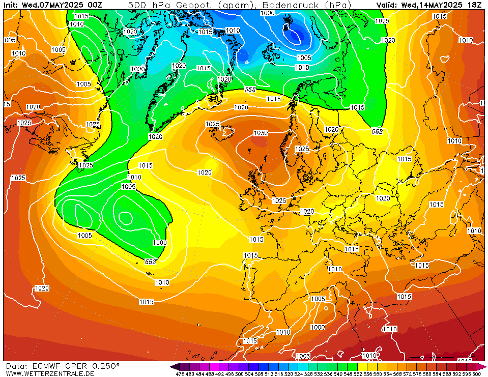
    Not to be taken seriously as this is an extreme solution and it is late but I had to post this in case it doesn't get banked.

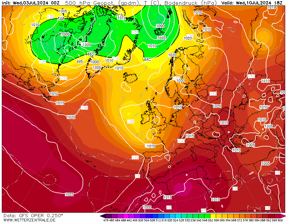
    GFS 18z has a high pressure fest and ends with a seriously impressive anticyclone right over top of the UK & Ireland getting geopotential heights close to 600 dm!? I don't recall seeing as cracking a chart as this in summer before and I've seen some spicy ones! Absolutely ludicrous.

    Widespread high 20s and low 30s would be expected with that, would we be in Ireland anymore?

    Anyway, should be back down to earth when you all wake up 😂

    image.png image.png


    Photography site - https://sryanbruenphoto.com/


  • Moderators, Science, Health & Environment Moderators Posts: 17,412 Mod ✭✭✭✭Gonzo


    Just taken a look at the pub run and it's a hot one, but there are several outliers that are much warmer than it. At the very least even the mid range runs are going to slightly high twenties so It's fair to say we are most likely looking at a very warm second week of July that may well last into the third week as well. However there are some colder runs and enough of them that they can't be discounted so a much cooler second half of July is also on offer. All eyes on every run over the next few days. We could have a 1995 on our hands here but we may also have a 2018 where we will get 5 to 10 days of very warm weather but the rest of the summer will be slightly warmer but nothing northworthy. Either way it looks like summer will begin from early this week and provide at least a week of bbq type conditions. For all we know summer could go down the tubes after this period or remain decent enough and another hot spell a bit later on.


  • Registered Users, Registered Users 2 Posts: 13,941 ✭✭✭✭sryanbruen


    Aye I was banking purely on the fact how extreme that high pressure was. Nearly 600 dam z500 in Ireland would be record breaking I'd have thought. I looked through reanalysis back to 1995 of notable anticyclones off the top of my head and none of them came as close with the 8th July 2013 being the closest comparable one. The potential of a record breaking heatwave here would be off the charts with that.

    Would be crazy.. 1 year on from what was already an exceptional heatwave in July 2021.

    No heatwave this morning but lots of dry weather. Still the general same theme.

    Photography site - https://sryanbruenphoto.com/


  • Registered Users, Registered Users 2 Posts: 7,447 ✭✭✭pauldry


    Met Eireann says there will be plenty of cloud all week and temperatures of 16 to 21c. The persistent West to Northwest airflow kills the start of it however from about July 9th to July 14th the high temperatures come. Then we wait to see will Low or High win.


  • Registered Users, Registered Users 2 Posts: 7,447 ✭✭✭pauldry


    Latest chart rolling out very 2011esq. More Southwesterly so more moisture with mist and drizzle in the North and West bar 1 or 2 days. South would get one or 2 very warm days 28 or 29c and lots of days of 24c but the West will have Summer for only 1 or 2days.


  • Advertisement
  • Moderators, Science, Health & Environment Moderators Posts: 12,668 Mod ✭✭✭✭Meteorite58


    ECM 0Z holding firm and the HP looking even stronger, higher and holding the pressure longer and that bit more centered nearer to Ireland, even keeping out LP's at the end of the run, more promising again for a good summery spell.

    modez_20220702_1200_animation.gif


  • Registered Users, Registered Users 2 Posts: 13,941 ✭✭✭✭sryanbruen


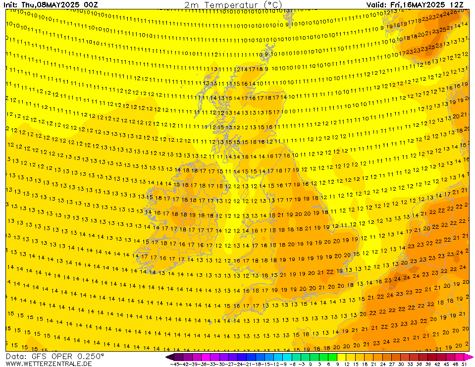
    Well GFS 18z has yet again gone mental... shows raw 30C in southern half of Ireland on the 15th July but I know this is an Irish forum and well, look at what it shows for England on the 16th July. This is not the NAVGEM. This is not a single ensemble. This is the GFS operational run showing widespread 40C and even shows 41C in SE England.

    Never seen anything like it.

    image.png image.png


    Photography site - https://sryanbruenphoto.com/


  • Moderators, Science, Health & Environment Moderators Posts: 17,412 Mod ✭✭✭✭Gonzo


    The charts posted by Syran are absolutely insane. I don't know which is the most impossible, southern half of Ireland getting into the low 30s widely or the south-eastern corner of England getting to low 40s widely. One of last nights charts got Shannon very close to 33C with widespread 30C across Munster and most of Leinster.

    This afternoons charts have scaled the warmth back somewhat to a more realistic scenario. Mid to high twenties for Ireland and low to mid thirties for the UK. Will tonights pub run be sensible or will it go on another bender.


  • Registered Users, Registered Users 2 Posts: 7,447 ✭✭✭pauldry


    Ya ìt would certainly be strange to get over 30c so suddenly. This is the first year in my lifetime that temperature of 21c has not been reached by July 3rd in Sligo. So coz its such a mental sort of a year I wouldn't put it past the weather to go over 30c in the next 2 weeks sometime.


  • Moderators, Science, Health & Environment Moderators Posts: 17,412 Mod ✭✭✭✭Gonzo


    Tonights pub run clearly on water with a few ice cubes to sober up more after last nights session. Temperatures for week 2 of July more conservative generally low to mid twenties. However this low to mid level warmth continues right up to the end of the run for eastern and southern areas. This pub run overall has the north-west of Ireland and Northern Ireland on a knifesedge with very little in the way of proper warmth there and more in line with recent GEM and ECM charts in terms of temperature with 15 to 20C for the most part. The temperatures for the UK have also being dialed back, generally mid twenties to low thirties in the south-east of England.


  • Moderators, Science, Health & Environment Moderators Posts: 17,412 Mod ✭✭✭✭Gonzo


    This mornings GFS 6z is similar to the pub run from last night but changes the position of the high pressure to allow cooler winds from the north-west to topple over the high into next week so gone are the high temperatures. However this GFS run keeps us generally under high pressure for a much longer period and it does get properly warm eventually, but the real warmth has been pushed out by another 4 or 5 days instead of having it starting Monday 11th.

    High pressure sets up this weekend.

    Untitled Image

    On this GFS run the high does not centre over us, it stays to our south and we stay on the cool side of the high with winds in from the west or north-west. This turns parts of the north-west fairly wet on the Monday and temperatures overall reduce nationwide to the 17 to 20C range instead of the high twenties which the GFS seems to have completely dropped.

    Untitled Image Untitled Image Untitled Image

    This is a fairly signifcant change for Monday the 11th of July compared to any of the models I've looked at over the past week. As this is a new turn of events from the GFS i'm not sold on how cool and unsettled these charts are showing.

    Tuesday 12th is another average day with temperatures generally 16 to 20C but much cooler across the north-west and west with north-westerlie winds around that high.

    Wednesday 13th see's the high re-establishing itself over Ireland and it is only from this point that we start to see low to mid twenties across Ireland.

    Untitled Image Untitled Image Untitled Image

    By the weekend of the 16/17 July mid twenties across the country with a few places possibly seeing high twenties.

    Tuesday 19th of July sees the breakdown to much cooler Atlantic conditions.

    Untitled Image

    If you like high temperatures, looks like we will need a little more patience to finally get there. I'm a bit surprised by the blip Monday/Tuesday 11/12th July but it seems the ECM is doing this too.

    ECM isn't looking great for next week with a good deal of support to end the warm weather around Sunday 10th of July, keeps that jetsteam far too close for comfort with the high too far south to tap into any real warmth.

    Untitled Image


  • Registered Users, Registered Users 2 Posts: 13,941 ✭✭✭✭sryanbruen


    It's happened again (after going sober yesterday), GFS 18z is on a bender. Moreso for the UK this time but either way, those 850s are worthy of a look.

    I don't know anymore man 🤣

    image.png image.png


    Photography site - https://sryanbruenphoto.com/


  • Posts: 0 [Deleted User]


    Apart from this week, has 40c ever shown up in FI charts for the UK? I don’t remember it ever happening.


  • Registered Users, Registered Users 2 Posts: 8,913 ✭✭✭Danno


    Yes, a few years back a 42c appeared just north of Southampton.


  • Registered Users, Registered Users 2 Posts: 13,941 ✭✭✭✭sryanbruen


    The only model I've ever seen it appear on was NAVGEM - it even showed a 40C over Ireland if I remember correctly? It's here on Boards somewhere when someone posted it. It might have even been @Danno ^ himself that posted it. I can't be bothered to search for it on this horrible Boards. My memory is fading here, usually good at remembering trivial things like this.

    I haven't been model watching for that long though so don't have a great history to reflect on, some long-term viewers and Mets saying the other night was the first time seeing it on an operational run on a model like the GFS.

    Photography site - https://sryanbruenphoto.com/


  • Advertisement
  • Moderators, Science, Health & Environment Moderators Posts: 17,412 Mod ✭✭✭✭Gonzo


    Tonights pub run went on quite a session and delivers +23C uppers briefly over Leinster as in extreme outlier almost on it's own. The Tip is almost off the scale.

    Next week is flirting some serious warmth.

    Untitled Image Untitled Image

    No chance of this verifying but it's fun to see.


  • Moderators, Science, Health & Environment Moderators Posts: 17,412 Mod ✭✭✭✭Gonzo


    An update on the extended range forecast covering the next 16 days or so.

    Up to Sunday 10th July:

    I have covered this section on the up to 120 hour thread but basically high pressure becoming established over the country with sunshine becoming more widespread. Cloud will vary from place to place and this will play a part in where see's the highest temperatures. Temperatures generally 19 to 24C, warmest from Friday to Sunday. The north-west will be cooler and more cloudy up to Friday but it does look like the good weather will eventually get there by the weekend with temperatures 14 to 19C up to Friday and 16 to 22C over the weekend.

    Untitled Image


    Monday 11th to Sunday 17th:

    Next week is looking warm to very warm right across the country with all areas enjoying some very warm and sunny weather. There is still some uncertainty with how warm it could get but generally temperatures between 22 and 28C can be expected this week with a few locations possibly getting up to 30 or 31C under extended spells of sunshine with minimal sea breeze influences. I'm thinking either Shannon or Mt Dillion would be the official stations that might reach 30C once conditons are perfect as long as the models to continue to verify about next weeks warmth.

    Untitled Image

    There are currently several GFS hot outliers going for hotter conditions than what I'm suggesting where low 30s would be widespread but these runs are too extreme for me to take them seriously.

    Untitled Image

    The models also suggest little to no rain over the coming 12 days with a possible breakdown beginning sometime between the 15th to 18th of July. As of this morning this spell of warm to hot weather is shaping up to be similar to the very warm spell we had last July, however the models are still getting to grips with next week's potential so expect anything from not as intense as July 2021 to more intense or somewhere in between! Either way this is shaping up to be a very warm July and the first half at least very dry.

    Untitled Image

    Currently the GFS is showing between 2 and 5mm of rain over the next 16 days with some higher totals across the east and south at the very end of this period, but these rainfall totals are relying on thunderstorm activity during the breakdown stages of the high temperatures so there is a fair chance many areas could escape without any rainfall until the 3rd week of July.

    There is a chance that this breakdown could be temporary and it's possible there could be a reload of very warm weather during the final week of July. The long range models are starting to suggest that August could be fairly poor and Atlantic driven so make the most of the lovely weather over the next 10 to 14 days, especially after the poor June and dissapointing first few days of July.


  • Registered Users, Registered Users 2 Posts: 1,139 ✭✭✭Neddyusa


    That's mad!

    Is the ECM much duller/damper? As the max shown on YR for here next Tuesday/Wednesday is 10C lower than above, with cloud and drizzle.


  • Registered Users, Registered Users 2 Posts: 7,447 ✭✭✭pauldry


    I don't think it's shaping up to be as good as last July in the West when lots of Mayo some of Sligo and many other locations got over 30c. I remember leaving Bundoran coz it was too hot. I also remember leaving the beach in Connemara coz the sand was too hot. We went to a park the next day and it was 31c.

    This year I wouldn't completely rule out it going over 30c in many locations near mid July and some stations have a small chance of their warmest July day on record but even if the West escapes these high temperatures science says heatwaves are only going to become more and more frequent so don't be surprised if most years we get at or near 30c anymore.

    Wonder will London hit 40c and France 45c. Exciting. If scary.


  • Moderators, Science, Health & Environment Moderators Posts: 17,412 Mod ✭✭✭✭Gonzo


    The shaping up is still taking place and will change slightly with each run over the next week. The 6z is rolling out now and brings the Atlantic back as early as the 13th, so this warm spell could end a bit earlier than I said in my post, anywhere from 12th of July to 18th of July. I am hoping this high pressure will continue to evolve and would love to see the warm and dry weather extend out beyond the 20th of July, but that is asking for alot! I think we will break 30C too at some stage over the next 3 to 4 weeks but it will be limited to one or two places and unlikely to be a widespread temperature. I'm not really buying into the London to hit 40C or more, it just seems excessive a bit like Ireland trying to get to 33C or more. The sun, moon and stars need to line up perfectly for something like that to happen.


  • Registered Users, Registered Users 2 Posts: 2,243 ✭✭✭squarecircles


    Its not like you to be pessimistic.


  • Registered Users, Registered Users 2 Posts: 7,447 ✭✭✭pauldry


    Yeah the 40c is deep in the realms of fantasy Island but keeps coming up. Probably turn out like the great blizzard prediction of last Christmas and be 17c!!


  • Registered Users, Registered Users 2 Posts: 2,232 ✭✭✭PukkaStukka


    Right now its the coldest summer I can remember since 1986


  • Registered Users, Registered Users 2 Posts: 7,447 ✭✭✭pauldry


    Yeah. See temperatures now and Sligo is 14c but Claremorris 17c and Athenry 19c pretty respectable Just Sligo and Donegal and Leitrim are freezing.

    Also 1986 had got well over 20c by July 5th in previous months. No year has had this cold in the Northwest. .... maybe 1886!


  • Advertisement
  • Moderators, Science, Health & Environment Moderators Posts: 17,412 Mod ✭✭✭✭Gonzo


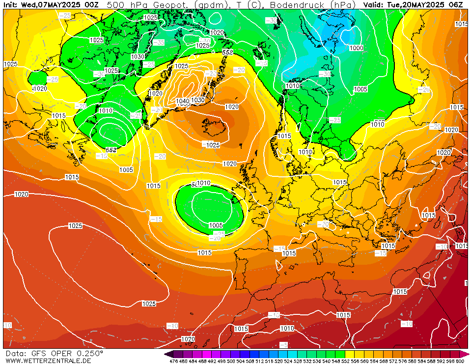
    Big change on the GFS 12z. The high pressure breaks down from Monday and we go back into a cooler north-westerly Atlantic driven flow and no heat at all next week! Think the GFS might be having a fairly major model wobble. Could be a cool outlier will have to wait and see when the set of runs complete.

    We will probably need a few more days to see are we in for a cool Atlantic driven week or will we maintain the high pressure and possibly pull up some very warm south-easterlies for a time. Could this be like the run up to the great bust of Christmas 2021 all over again!

    GEM 12z keeps the heat throughout next week.


This discussion has been closed.
Advertisement