Advertisement
If you have a new account but are having problems posting or verifying your account, please email us on hello@boards.ie for help. Thanks :)
Hello all! Please ensure that you are posting a new thread or question in the appropriate forum. The Feedback forum is overwhelmed with questions that are having to be moved elsewhere. If you need help to verify your account contact hello@boards.ie
Model Outooks: Winter 2008/2009
Options
Comments
-
Looking at the 12z it would continue to show the main potential is pretty far off, post Jan 1st in fact where the ensembles are pretty split though they never handle these situations well.
This is still very much up in the air as it were (/I'll get my coat..). :P
I think the best forecast anyone can give right now with any kind of accuracy is that its going to be cool , at least for the next week, with increasing amounts of sunshine, especially in the west and with night frosts getting increasingly severe away from the east coast. All in all not a bad spell of weather.
The longer it lasts the deeper the home grown cool pool here, which even if the worst comes to the worst, may give some snow on the breakdown as a result.
That said right now i cant see any decent countrywide snow events for the foreseeable future (7 days roughly) or any precipitation for that matter bar some east coast drizzle maybe on Sunday night or Monday.
The potential is there though for a classic, I don't think that can be written off yet by anyone with any degree of certainty for sure.Have a weather station?, why not join the Ireland Weather Network - http://irelandweather.eu/
0 -
TBH, the GFS 12z is interesting in that there is no real mild weather in the reliable timeframe. After that, most models are going for a cold breakdown.
Bring back BB !0 -
Folks, its a pleasure to come in here and see the ramping up that happens occasionally :rolleyes: as it brings out the child in us all. Still we're all adults (most of the time) and can take in in the spirit it's intended with a dose of reality thrown in. The elusive sonw event is a bit like Christmas, it's all in the build up so the forum play a huge role in that for us all even those of us whoo can only read and not post as we know nothing of the science underpinning it.
Everyone's post is valuable, without them there is no forum but as a previous poster said, play the ball and not the man. Let's stick to the weather and leave the personal stuff aside. Thanks and a Happy Christmas to all.
I agree with every word said here. This is only a hobby (or perhaps a fixation for some!) and its understandable that passions can run a bit and things can be said in the heat of battle. Let's not fall out with one another over the meaning of charts or whatever. That in itself won't change the weather one bit now, will it?
Happy Christmas one and all!") 0
0 -
Naw Black Brier , would'nt like to see you depart , unlike me your a quality poster and you know your stuff , it's just its not nice to see one member being so dismissive of anothers efforts ( thats my opinion )....If SAs charts come off great , and if they dont they dont and so be it
 , so BB take that pet wolf of yours for a long walk in that biting Southerly breeze , clear the cobwebs , and report back here again soon mate .
Anyway (and still completely off topic) going back to my job as chief sherry sampler in the KY household , itz nott a pleezentt jjob but sumwan moost jo itt.......:rolleyes:
MERRY CHRISTMAS EVERYONE...... 0 -
The ECMWF run has completed, and although I'm an optimist, I must admit that this run is disappointing. Once again the cold is held back somewhat. Although there are substantial height rises over Greenland at T+168, the high itself has not fully retrogressed to Greenland by any means. Furthermore, there is quite a worrying evolution out around T+240, with the high sinking over the country.
Its a risky setup shown on the ECMWF tonight. If this was GFS, I would be dismissive, although given that its ECM I am concerned to say the least.
I think that subsequent runs are needed, and I have not yet viewed the ECM ensembles to see where the operational run sits, but this is not encouraging to say the least.
However, this run could be a warm outlier as was the GFS operational for the 12Z run today. Further outputs needed, but the news is not so good on this Xmas Eve in terms of operational model outputs at least. However, the underlying trends are still ok at this point. GFS ensembles clearly point toward a colder evolution, and the UK Met Office were very confident with their medium range forecast today.
A bit of a dubvious time now really to see if the operational outputs are onto something or if they are indeed just mild outliers.
Once again, a very happy Christmas to all.
Regards,
SA.") 0
0 -
Advertisement
-
Dissapointed now, All this change makes me wonder why anyone bothers posting and montiroing charts for long range forecasts , I mean if you say something last week for the 5th of january but then 7 days later its different then obviously u have to put a question over the whole thing , dont understand why it changes.0
-
Dissapointed now, All this change makes me wonder why anyone bothers posting and montiroing charts for long range forecasts , I mean if you say something last week for the 5th of january but then 7 days later its different then obviously u have to put a question over the whole thing , dont understand why it changes.
Its an outlook not a forecast thread, noting written in stone till you see the new thread about the upcoming event.0 -
I generally don't bother with model threads including reading them, but took a browse here as the post count seem to go up quickly. Glad its lively somewhere, because the weather sure isn't!...but that means silly season for threads such as this.
The way I see, we should probably take a weeks holidays, apart from being a little colder, it'll be somewhat like groundhog day and little will have changed with our current weather, but at least in a weeks time we will be a week nearer to the breakdown and probably a bit wiser as to when and what the breakdown will be. If not take another weeks hols!!
So roll on 09 and when breakdown is within a more reliable timeframe then I'd really like to read BB's opinion.0 -
Dissapointed now, All this change makes me wonder why anyone bothers posting and montiroing charts for long range forecasts , I mean if you say something last week for the 5th of january but then 7 days later its different then obviously u have to put a question over the whole thing , dont understand why it changes.
Hey Pangea. Well I have very good news from the GFS 18Z run. The operational run might not have been brilliant, but the ensembles have now even improved more, as you can see below. The mean 850HPA temps now drop below -5 right out until the end of the run. This is still in FI, but the sharp drop begins from the 3rd of January as you can see below. Many perturbations trend down to and below the -10 line, which is very promising in my opinion. I expected GFS operational to go like this today, with many perturbations trending much below it.
Now the projected sharp drop in cooling is still 240 hours out from this point, however it is slowly making its way towards the more reliable. Whether it will actually occur is still very much uncertain and up in the air, but the signs are there for it. What does worry me is the ECM run this evening and its sinking high solution - Because as BB stated earlier this evening it has very good accuracy when compared with the accuracy of GFS. Otherwise I think things are quite encouraging. Its still FI, caution very much advised, but these set of ensembles are very very good, with GFS operational once again being a mild outlier, so this possible wintry outbreak cannot be ruled out by any means yet. If GFS operational trends like one of the many colder perturbations any time soon, then expect another very cold run from it. However, this may not happen either.
I think this set of ensembles is a very nice output for Xmas eve, but remembering they are still in FI to deep FI (With the main onset of cold projected 240 hours out). Furthermore, there are clearly still some perturbations going for milder solutions.
And although this onset of the much colder weather projected on the latest chart is very much in line with the UK Met Office medium range forecast today, the Met Office forecast is also subject to change. However I do think that they must have a high level of confidence so issue such a wintry forecast so far out at this point.
Next few runs will be interesting, but I think its necessary that we see ECMWF coming back on board, or there could be some problems.
In conclusion, a set of mixed outputs today.
Regards and Happy Xmas to all.
SA. 0
0 -
Bring back BB, I think we need the dose of reality that is associated with experience on summarising these model outputs... however any personal swipes must be avoided at all costs for this forum to prosper and grow.
I have previously nailled my flag to the mast in stating that I feel that the projected model outputs will come to fruititon. There are a few reasons for this...
1) I feel that the models are seriously under-estimitating how quickly the continent will cool off.
2) The fetch of the proposed air, despite it being via Med, will still deliver because of the dew points... remember, the models largely discount local topography.
3) When I talk about local topo, I am not speaking of the 900m Wicklow Mtns, I am talking about the Massif Central in SE France. Once [to be] air crosses that region it will sink like a stone from 2000m and dry out like dust. This allows cold dew points to persist in the journey to our shores
4) The recent unbelievalble snowfalls that have hit SE Austria were from 850hpa's of 0 to 2c. - They got savage snowfall.
5) We have been under the influence of the continent since Monday afternoon, look at the roads and pavements and see how dry they are... this is a precurser to cold air.
Will post more tomorrow [Lappy battery low] - but this is looking excellent IMHO.0 -
Advertisement
-
I'll add my 2c to this as i'm more in touch with reality today than yesterday.
There is two other things about weather i like and that is watching and talking about it.
I must admit, this forum as adult as it can be, there is a little ramper in each of us (ok some more than others) when an event is in the making.
There is a few things that bother me, sensationalism and pure hypebole, attacking a poster and not his post and the rallying up of support against another poster, there all a serious no no with me.
This is a discussion forum and posters are entitled to their opininon within reason and on topic. Many on here bring some sort of experience to the table, some have worked in a Met Organisation, climatology and have a keen interest in Meteorology and studying most of their lives etc and know what they talk about. Some can talk more than others, some argue their point more and some just seem to want to fuel a heated situation more, yes banter is allowed here but lets be all adult for the mo, this is the largest weather forum in this country, You can get first hand look into the models and forecast's from here, it is 99% a friendly place to have a discussion and if a poster doesn't agree with another post he/she is allowed to express him/herself within reason (the other 1% was the crap i used to take from a certain few on here when i use to mod this forum on my own)
I can agree to an extent with BB as i know entirely where he is coming from when he is commenting on SA model predictions about being in FI, i also agree with him when he mentioned some posters only want to read what they want to hear. I just think he got his point across in a different mindset than what others are more used too. I know this as myself and BB has had a few argys in the past. We argued our points as we where both right and all that. I'm not saying this is right or this is wrong, this is the interweb tbh.
Ok what happened might have been a wrong side of the bed thing with BB yesterday and probably feels a bit of a tit this morning vacating the area as he did but i have seen worse 'insults' eleswhere throughout boards. Lets all just take it on the chin and move on.
With regards to SA, keep doing what your doing and posting up the charts your doing, this is a 'model thread' and not a 'its going to happen thread'.
Lets move on
ECM looks good this morning. No retro but heights build over GL. SA don't forget about the Jet, the southern arm and N arm of the jet will play it's part in shaping the HP for us.
Edit: Happy Christmas everyone 0 -
Good morning all. Well several people on the UK forums have been saying that there is a lack of data input in the models today, so the ouputs should be viewed even more cautiously. I'm not sure whether this is the case or not.
However, the 00Z ensembles are once again very very good.
Even GFS operational brings upper 850hPA temps of -10 over us at one point in the run. The trend is still there for a sharp cooldown commencing between the 3 - 5 of January. On this run, some of the perturbations for Dublin approach -15. Also, the mean stays well below -5 for the remainder of the run. However, this projected cold outbreak is still 228 hours from now, so caution very much advised as of yet.
The 00Z ECMWF run is not very good up to the T192 timeframe from what I can see for the 00Z run, but improves markedly for the final two frames.
All in all this morning, while the GFS ensembles are still very very good, I still think the recent ECMWF outputs are concerning. However following on from that ECM T240 chart would be an incursion from the northeast /east. This would correlate with the recent GFS ensemble outputs. The possible lack of data must also be considered when viewing today's outputs, but I do stand corrected on that one.
Regards to all,
SA. 0 -
A fine post Snowbie, and worthy of a second reading. However, as a relative newbie on the forum, I can't accept that we have to accept blantantly aggressive posts that wear the guise of "differing delivery styles".
My concern about the discussions on this very thread over the last couple of days is the lording over of one opinion over an other. I have a huge love of weather, amongst many other things, and I have studied it in my own personal time ever since a child. I am no expert, and will accept criticism when it is fair and balanced; but when I get talked down to, I react, so I understand completely why others do to.
Secondly, I opened this thread so all who wanted to discuss model outputs could do so, and yes, that include outputs in the infamous fi range. Some may have a problem with that but I personally can't see why since it is the nature of the beast so to speak, and when people come to deliberately dismiss other folks fair and balanced opinions without offering any scientific or analytical discussion, then that is a very big NO NO with me.
This is not me being harsh or aggressive, or abusing my new found moderator priviledge, but I have an interest in other peoples views on model outlooks, and all things weather really, but I hate to see blatantly dismissive responses. It is my personal bug bear, and when I get personal...:P
and as Snowbie says, Happy Christmas y'all. 0 -
Snowaddict wrote: ».
All in all this morning, while the GFS ensembles are still very very good, I still think the recent ECMWF outputs are concerning. However following on from that ECM T240 chart would be an incursion from the northeast /east. This would correlate with the recent GFS ensemble outputs. The possible lack of data must also be considered when viewing today's outputs, but I do stand corrected on that one.
Regards to all,
SA.
Yep SA, ECMWF a real concern this morning, particularly as you say in the 144hrs/192hrs region. Having looked at the charts again, they still look quite unusual (if only it was summer, thunder galore!!!). That straight run of southerlies running right up into Iceland look like dragging some warmer heights up there along with them, which explains the persistence of the high over East Greenland/North Iceland in the charts.
While not looking fab, the ECM run seems legit, with plenty of potential for a cold snap in early Jan. Until then, at least we have a relativley cool easterly to look forward to. Not a dream easterly by any means, but at least it isn't the usual Azores crap we are use to!!:)0 -
I just thought that I would post this link below. Its a link to the new parallel GFS run on Meteociel. After each GFS operational output is completed, this run then takes place. Its been stated on UK forums that this run, runs at 6% higher resolution, however I'm not 100% sure. Basically, I think its a more fine tuned run from what I gather.
http://www.meteociel.fr/modeles/gfse_cartes.php?ech=6&code=0&mode=1&runpara=1
SA. 0 -
Enough of the drama and lets talk about weather
Snow addict ,are you saying that we could have tempertures of -10 and -15? :eek: :cool:
Merry Christmas0 -
Enough of the drama and lets talk about weather
Snow addict ,are you saying that we could have tempertures of -10 and -15? :eek: :cool:
Merry Christmas
Hey Pangea. These temps are not for sea level (or the 2m temperatures), they are the upper 850hPA temps. A general rule of thumb is that you need upper 850hPA temps of at least -5 in order to allow for snowfall. However, there are exceptions to this also.
The actual surface 2m temperatures (for the surface) are shown in this chart below. However, if, hypothetically, snowfall was to occur, then these would be lower. A nice set of 2m temperatures though it must be said for the 00Z run, even fairly cool temps for the next few days. Quite to very low daytime maxes are then suggested from about the 3rd/4th of Jan, but remebering that this is still in FI. What I will say though is that the recent operational outputs do still bother me. I will do a summary of the 06Z ensembles later, and we shall see how things are trending from that run.
Regards,
SA.
2 Metre - Surface temps - GFS 00Z 25/12/2008. 0
0 -
Very odd charts this morning, not sure what quite to make of them. I get the distinct impression that the models are struggling with the evolution of the high that's giving us this wonderful weather currently :pac::D
Have a weather station?, why not join the Ireland Weather Network - http://irelandweather.eu/
0 -
Very odd charts this morning, not sure what quite to make of them. I get the distinct impression that the models are struggling with the evolution of the high that's giving us this wonderful weather currently :pac::D
Certainly are. I wonder does a potential lack of data input today add to this also?
GFS 06Z ensembles not bad at all, with several perturbations again breaking the -10hPA temperature line from the 3rd of January onwards. Again, the sharp cooling trend is shown to begin between the 3rd and 5th of January. Some perturbations approach upper temperatures of -15, which is significant. There is also big scatter on this run, showing the vast uncertainty that has developed in over the last 18 hours or so.
Therefore, I would be cautiously encouraged for the moment by the ensemble graph below, given that the main onset of cold is still some 200 hours or so out (FI territory).
The latest update from the UK Met Office is very indicative of the uncertainty that we are seeing in the models at the moment and is not very encouraging to say the least:
I think that something has happened in the last 18-24 hours that has caused a major shift in some of the model outputs. Its a case of waiting now to see what outputs follow.
UK Outlook for Tuesday 30 Dec 2008 to Thursday 8 Jan 2009:
High pressure will continue to dominate the weather in the period, although with uncertainty over the temperatures. It will be mainly dry, chilly and fine through the first week, with variable cloud but also some sunny spells. Overnight frosts are likely with mist and fog patches. The following weekend looks as though high pressure will continue close by the UK with broken cloud, sunny spells and possible overnight frosts. A few showers may affect northern areas, possibly with some milder air with a little rain in the far west. In the following week it looks as though high pressure will remain to the west of the UK with temperatures near normal or slight below and possible overnight frosts. A few showers may affect northern areas, these wintry over the hills.
Thats a major turnaround from the UK Met Office and it greatly reduces confidence in this colder outbreak.
There is now a very good cause for conern in my opinion, but I would await further outputs before writing anything off just yet.
Regards,
SA. 0
0 -
Join Date:Posts: 16621
judging from above posts are they saying that its already gone pear shaped before things even got started?
looks like only thing were certain of is a week of dry, cloudy and cool conditions rather than cold.0 -
Advertisement
-
judging from above posts are they saying that its already gone pear shaped before things even got started?
looks like only thing were certain of is a week of dry, cloudy and cool conditions rather than cold.
Yep, thats a very accurate summary of the next 7 days. Well I want to wait for more runs as of yet, but some major change has occured in the last 24 hours, which seems to have been picked up by the operationals so far. To be honest, I don't know what the outcome is going to be at this point. It could go either way. The 12Z GFS ensembles are most important I think, as are the ECMWF 12Z and 18Z GFS runs this evening. If they continue or worsen the recent operational trend, then it can be almost certain that there is trouble on the cards for this potential colder outbreak.
As of yet, all hope is not lost.
But there's no denying that its not looking encouraging at this time.0 -
Latest run seems to be a good deal different with a greenland high developing .:cool:Then moves into europe giving them a cold spell. the jet seems weaker on this run allowing it to happen. interesting how different that is to last run.Also the atlantic is so weak with a pathetic looking low pressure giving us southerlies for a few days.
Way out in FI there is a amazing high over scandanavia and a warm cold battleground over ireland if this happend it could give significant snow- but it wont that fdar out in FI- but its nice to dream.All the good stuff is in FI so may as well be ignored and also it affects mainland europe while we are in the mild muck on the periphery.0 -
Ok, well GFS operational 12Z run has completed.
It now appears that a pattern change is coming up, not previously identified by some of the model outputs. The first high sinks into the continent, but with continued height rises over Greenland, the atlantic never really gets in, and by the 5th - T+276 onwards; we have a northeasterly flow developing over Ireland. Upper 850hPA temps drop to -10 in eastern areas. A low over southeastern Europe then pushes this colder air eastwards over the UK and Ireland. GFS operational suggests potent easterlies on this run, but its still in the FI timeframe and going on recent outputs, I wouldn't put much on it happening. In essence, the FI setup on this run is February 1991, with a substantial Scandi high.
I really don't know what to make of the latest run. Some very strange synoptics to be honest. Ensembles will be out in about half an hour from now, they should give us a broader view.
SA.
GFS 12Z T+288
GFS 12Z T+ 348
0 -
GFS 12Z Ensembles - 25 December 2008
In the more reliable timeframe, the ensembles agree with GFS operational regarding a slightly milder period around the 1st of January 2009, with upper 850 hPA temps averaging 3 to 4.
Thereafter, and into FI, once again there is a clear cooling trend in evidence. The sharp drop again takes place over the 3rd to the 5th of January 2009.
Indeed, GFS operational has great support for the colder outbreak is showed on the 12Z run, with many perturbations once again breaking the -10 850hPA temperature line. GFS operational is a mild outlier for around the 3rd to the 4th of January, suggesting that many perturbations bring in the cold earlier, as does the GFS control run which trended down to -13 on this run (Upper 850 hPA temps).
Therefore, according with the ensembles, the (average) main onset of cold is approximately, 220 hours out still. Whether or not it will occur is very very much uncertain at this point. Its going to be another 5 GFS runs before these ensembles begin to approach the slightly more reliable timeframe.
Either way, ECMWF is going to be important tonight. Furthermore, there is now a consenus for the first high pressure which is over us now to sink away to the southeast. That cooling trend is still making its way slowly towards the nearer timeframe.
However, in light of recent developments, confidence in an early new year wintry outbreak has to be somewhat lower at this point at least.
Regards,
SA. 0
0 -
ECMWF Run 12Z 25 December 2008.
Terrible would describe this run for the longer timeframe, and better than the previous run up to T+144. It is at complete odds with the majority of the GFS perturbations for the longer timeframe.
If GFS trends towards ECM, there is trouble ahead for the potential of this cold spell.
Up to T+144, one would think that the high is going to retrogress after appearing to sink originally, however after that it fades out in situ and a mid atlantic type block develops, with what appears to be westerly winds following for the very end of the run. Quite a disgusting output given the recent one's to be honest.
If you combine this output with the UK Met Office update today, things are not looking so good at the moment. If the GFS 18Z perturbations (which I will post later on, at 11.20pm approx) push the potential cold further out or if there are many more milder members than compared with previous runs, then we have a problem.
As I said earlier, something has changed in the past 24 hours, going on the latest ECM outputs.
In summary, if you were to base a T+240 hour outlook on the ECM model tonight, there would be almost no potential for the colder outbreak. If you were to base it on the recent runs of GFS perturbations, there is great potential for a colder outbreak.
Not sure where this is going, GFS 18Z perturbations will be very important.
Regards,
SA.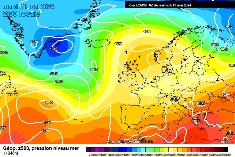 0
0 -
Just a bit information which may be helpful regarding the recent outputs.
Another forum is Uk Weather World, on which the following statement has been made this evening:
''"Whatever the outcome - please remember to treat model output with caution over the next 48 hrs. A lot less observational data generally gets fed into the Numerical Guidance over Christmas due to fewer obs, aireps and soundings. Generally model output is imo quite erratic over the Christmas period''
This might be a bit of encouragement regarding recent outputs.
GFS 18Z will be out now in a few hours..
Also, regarding the outputs today.
A statement from NOAA today says the following:
''EWD VERY
STRONG POSITIVE HTS ANOMALIES OFF THE BRITISH ISLES RETROGRADE
TOWARDS THE DENMARK STRAIT SUPRESSING WEST ATLC RIDGING.
SOME DAY 6 AND 7 WED/THU MODIFICATION OF EARLIER PRELIMS FOR AFTN
FINALS MORE TOWARDS THE OP 00Z ECMWF.''
The Denmark Strait is an area between Iceland and Greenland, esentially to our northwest. So this is important at least.
SA. 0 -
The RTE/Met Eirean forcast was less than exciting in this regard, the 5 days graphic showed max temps of 7/8/8/5/8 I think.0
-
General discussion on model outputs this evening and tonight
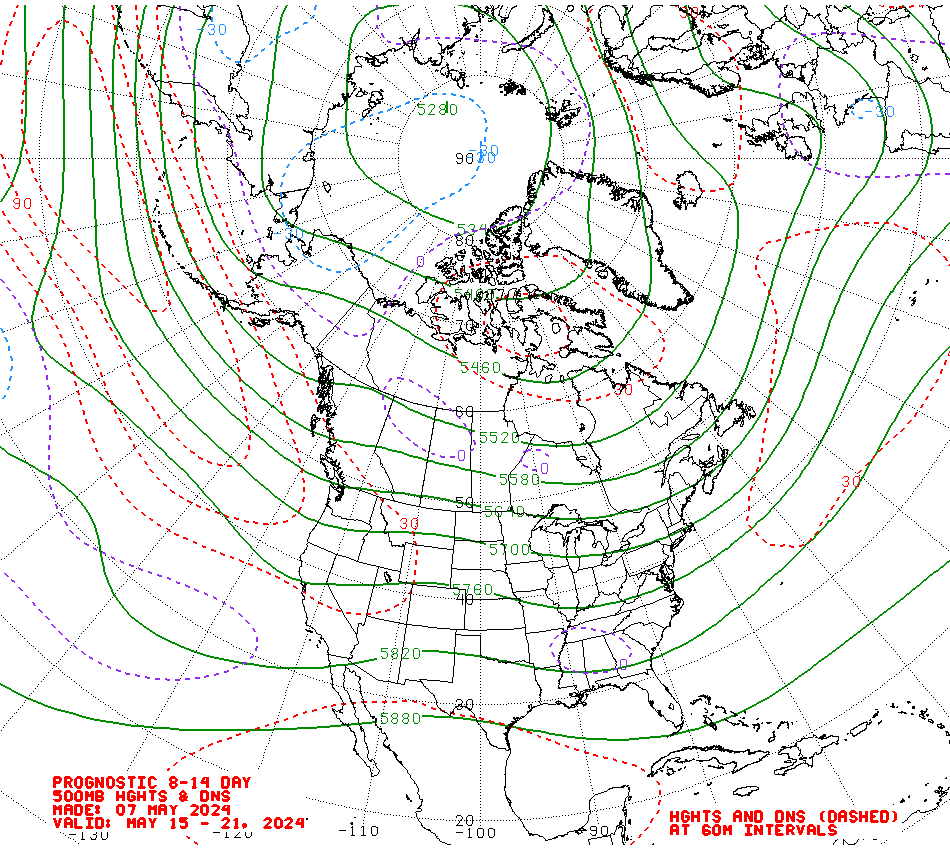
Latest Updates - CPC Charts - United States
The folks at CPC in the United States were certainly working today, and here are the updated 500mb Prognostic charts through to day 14. They have been updated today and have been issued with 60% confidence.
Both of these charts show extremely positive height rise anomolies over Greenland and the surrounding area for the duration of the next two weeks. This is very supportive of the notion of the presence of high pressure over the area between southern Greenland and Iceland:
CPC 500mb Prognostic Height Chart - Day 6-10
http://www.cpc.ncep.noaa.gov/products/predictions/610day/610day.03.gif
CPC 500mb Prognostic Height Chart - Day 8-14
http://www.cpc.ncep.noaa.gov/products/predictions/814day/814day.03.gif
18Z GFS Ensembles
The 18Z ensembles are now out, and once again its fairly good news (Although this still corresponds to a time period thats still between 195 and 215 hours out from now, so nothing is still certain). The marked cooling trend between the 3rd and 5th of January is still there, and continues out until the end of the run, although the mean does again rise above the -5 850HPA temperature line to -4 towards the very end of the run.
A very important point to note is that on this run, GFS control was extremely cold, suggesting a very cold easterly.
There are a clear cluster of perturbations trending towards and below -10 on this run. However several perturbations also go for much milder solutions.
The potential is still very much there for this colder outbreak. On tomorrow's runs, the operationals will either come on board at some point or the various ensembles are going to start trending towards the operational outputs. If the latter happens, then our potential new year cold spell might not have much potential anymore. However, we will have to await tomorrow's outputs to see.
I would also like to direct everyone to a very important post on Net Weather this evening, which gives an excellent analysis as to where we stand at the moment.:
http://www.netweather.tv/forum/index.php?showtopic=51794&view=findpost&p=1401757
Latest JMA Model Output
Now, I know that some don't rate JMA, but they have also been in working today, and here is the T+192 chart from tonight's run:
It is clearly suggestive of height rises over Greenland with severe cold to our east. Whether it is actually on to something, as suggested by several of the GFS ensembles is another question which hopefully, the answer to which will become clearer tomorrow.
http://www.wzkarten.de/pics/Rjma1921.gif
GFS 18Z Parallel 18Z Run
One final addition tonight refers to the 18Z GFS Parallel Operational Run - Which is available on Meteociel.
Its an absolute peach of a run. The main thrust of colder air again arrives from the east between the 3rd and the 5th of January, with 850hPA temperatures over Ireland remaining at between -8 and -11 right out until the end of the run. Of course the major caveat is that this wintry outbreak shown on this run is still approx 200 hours out, although the building blocks come into place between T+174 and T+192.
This is indeed but one run, but it also demonstrates clearly that all hope is not lost yet regarding this potential wintry outbreak into the new year. Indeed, if this run verified, there would be large amounts of snow countrywide. The problem however is that this is but one run, and as stated above is still for the FI time range. I'm not going to post the charts because they update with each run, and so the run could be completely different by the morning, which would make this post look senseless. The recent words of Joe Bastardi: 'patience grasshopper, patience' regarding his idea of the colder wave to hit Europe may yet come into play.
Later on, on today's outputs we do need to see better outputs from ECMWF and a continued clear cooling trend of the GFS outputs in order to maintain any level of confidence for this possible new year wintry outbreak.
Regards to all,
SA. 0 -
after telling loved ones last week that we are in for a very cold new year, I have now begun to dismiss it .
 0
0 -
Advertisement
-
after telling loved ones last week that we are in for a very cold new year, I have now begun to dismiss it .
well, at the risk of sounding obsequious, it pays to take the views of the more seasoned posters on board, who are measured in their approach to what the models indicate long term. while it is fun speculating and being enthusiastic, what we must always bear in mind is that immutable law of physics (murphy's law)- what can go wrong usually will go wrong :mad::mad:
i don't mean to take a swipe at anyone with this post. just that there is less heartbreak if we keep grounded about these things.0


This discussion has been closed.
Advertisement