Advertisement
If you have a new account but are having problems posting or verifying your account, please email us on hello@boards.ie for help. Thanks :)
Hello all! Please ensure that you are posting a new thread or question in the appropriate forum. The Feedback forum is overwhelmed with questions that are having to be moved elsewhere. If you need help to verify your account contact hello@boards.ie
Hi all! We have been experiencing an issue on site where threads have been missing the latest postings. The platform host Vanilla are working on this issue. A workaround that has been used by some is to navigate back from 1 to 10+ pages to re-sync the thread and this will then show the latest posts. Thanks, Mike.
Hi there,
There is an issue with role permissions that is being worked on at the moment.
If you are having trouble with access or permissions on regional forums please post here to get access: https://www.boards.ie/discussion/2058365403/you-do-not-have-permission-for-that#latest

Interesting Maps

13435373940161

Comments

  • Banned (with Prison Access) Posts: 9,078 ✭✭✭IAMAMORON


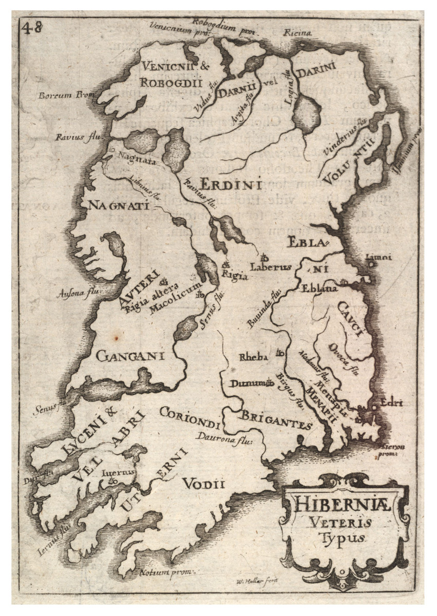
    Hibernia

    protestant-st-patricks-day.jpg


  • Banned (with Prison Access) Posts: 9,078 ✭✭✭IAMAMORON


    Albion & Hibernia

    1d4657225d3e68bc7abdaacd9da1f47a.jpg


  • Registered Users Posts: 1,462 ✭✭✭jogdish


    Got ' All over the map ' a great (coffee table) book full of various interesting maps.


  • Banned (with Prison Access) Posts: 9,078 ✭✭✭IAMAMORON


    This looks possibly early Norman, I stand to be corrected.

    anc-all-eire.jpg


  • Banned (with Prison Access) Posts: 9,078 ✭✭✭IAMAMORON


    Cill Mhantáin

    county-wicklow-antique-map-for-lewis-by-dower.-ireland-1846-old-362904-p.jpg


  • Advertisement
  • Banned (with Prison Access) Posts: 9,078 ✭✭✭IAMAMORON


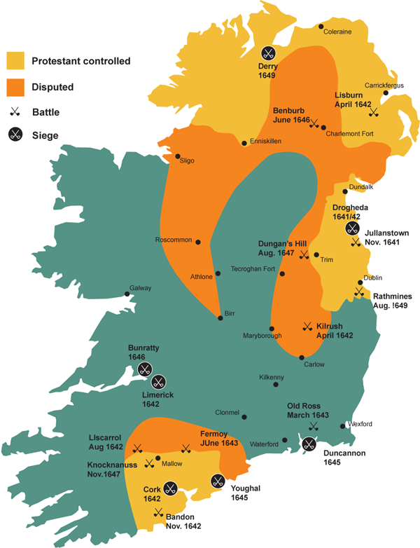
    Confederacy Rebellion of 1641 - 11 years war.

    confederate-wars-map.png


  • Registered Users Posts: 5,382 ✭✭✭Duffy the Vampire Slayer


    humberklog wrote: »
    Are you sure they weren't saying "Three Guys" and not Tesco?

    Fairly sure the Tesco name only came into Ireland in '97 but Crazy Prices (Quinnsworth) took over the Three Guys shops and they were still commonly referred to as that or Gubays.*

    HWilliams took over Three Guys first but that didn't last long.

    There were a few Tesco shops in Ireland in the 70s and 80s. One was in Westside in Galway.


  • Registered Users, Registered Users 2 Posts: 19,085 ✭✭✭✭BonnieSituation


    There were a few Tesco shops in Ireland in the 70s and 80s. One was in Westside in Galway.

    Thanks!

    That extra piece of info led me to find this:

    https://www.skyscrapercity.com/threads/supermarkets-of-times-past.1373113/

    https://www.emerald.com/insight/content/doi/10.1108/eb018304/full/html?skipTracking=true

    Seems they bought 3Guys in 1979 and left in 1986. Phew.


  • Registered Users Posts: 5,382 ✭✭✭Duffy the Vampire Slayer


    I was very surprised to learn that there was once a Tesco in Westside (It's now a Dunne's), but everyone who lived in Galway in those years could remember it.


  • Registered Users, Registered Users 2 Posts: 19,085 ✭✭✭✭BonnieSituation


    I was very surprised to learn that there was once a Tesco in Westside (It's now a Dunne's), but everyone who lived in Galway in those years could remember it.

    Yeah. I'm too young to have ever seen the original Tesco in Ballyer as I was only 2 when they left, but it was always just referred to as Tesco even when Quinnsworth was there. It was still referred to as Quinnsworth when it changed to Crazy Prices and when Tesco Ireland came in. :)


  • Advertisement
  • Moderators, Politics Moderators Posts: 40,287 Mod ✭✭✭✭Seth Brundle


  • Registered Users, Registered Users 2 Posts: 19,085 ✭✭✭✭BonnieSituation


    I'm assuming a lot on here have been keeping up with the antics across the pond and as such have become rather au fait with the composition of counties in some states.

    So with that I'd thought I would share an anomaly that ha annoyed me for a while.

    Iowa

    Iowa has 99 counties.

    Now some of you might be all, "so what?", and that would be fair I guess, but it's only when you look at a map of Iowa that you see the annoying thing about why there are 99 counties...

    iowa-county-map.gif

    See it...?

    Fifth county in from the left...

    kossuth.gif

    Yeah, Kossuth County. Gah.

    There was in fact a 100th county called Crocker County (1870-1871).
    Wikipedia wrote:
    In 1870, the Iowa General Assembly created Crocker County from the northern part of Kossuth County. The county seat was located at Greenwood, Iowa. In December 1871, the Iowa Supreme Court declared the act creating this county a violation of the constitution, which in article eleven declares that no new county shall be created which contains less than 432 square miles. As Crocker County was smaller than the law allowed for, it ceased to exist from and after the rendition of that decision and the twelve townships in its territory reverted to Kossuth County

    https://en.wikipedia.org/wiki/List_of_counties_in_Iowa

    So there ya go.


  • Banned (with Prison Access) Posts: 9,078 ✭✭✭IAMAMORON


    Iowa_1905_Census_Map_Indian_Terr_Accessions.jpg

    history-education-pss-removal-indianterritory-source.jpg


  • Moderators, Recreation & Hobbies Moderators, Science, Health & Environment Moderators, Technology & Internet Moderators Posts: 92,450 Mod ✭✭✭✭Capt'n Midnight


    ZengTEC.jpg


  • Registered Users, Registered Users 2 Posts: 40,513 ✭✭✭✭ohnonotgmail


    ^^^^^^^^^^^^^
    You can see why traveling west to california was such a big deal


  • Moderators, Recreation & Hobbies Moderators, Science, Health & Environment Moderators, Technology & Internet Moderators Posts: 92,450 Mod ✭✭✭✭Capt'n Midnight


    ^^^^^^^^^^^^^
    You can see why traveling west to california was such a big deal
    The other options where to cut across Panama. Except it wasn't Panama. And there wasn't a canal.

    Or rounding the horn. Sailing through some of the worst weather at the bottom of south America.


  • Moderators, Recreation & Hobbies Moderators Posts: 11,645 Mod ✭✭✭✭igCorcaigh


    The other options where to cut across Panama. Except it wasn't Panama. And there wasn't a canal.

    Or rounding the horn. Sailing through some of the worst weather at the bottom of south America.

    Interesting. Is that why there was a "wild west"?
    Did the native population seek refuge there?


  • Moderators, Recreation & Hobbies Moderators, Science, Health & Environment Moderators, Technology & Internet Moderators Posts: 92,450 Mod ✭✭✭✭Capt'n Midnight


    igCorcaigh wrote: »
    Interesting. Is that why there was a "wild west"?
    Did the native population seek refuge there?
    "To hell or to Connaught"

    native-american-land__.0.0.gif

    Only if by seek refuge you mean forcefully evicted time and time again from land given to them by treaty with the US. In total there were about about 370 treaties and the US broke every single one of them.


    Trails_of_Tears_en.0.png
    The Trail of Tears. Notice how different from Florida the reservations were.

    The Choctaw Nation donated $170 to famine relief in Ireland a little later on.


    More on the earlier history here. If you go back further you can see how the Puritans treated the original inhabitants who saved them from starving that first winter.
    https://www.history.com/news/native-american-land-british-colonies

    treaty-of-paris-us-map-gettyimages-71082458.webp

    went to this

    map_of_territorial_growth_1775.webp


    And there was French funded War that led to the US Independence and end of controls from England and tearing up of treaties and annexing those areas.


    Back to the question. Many of the areas in the West were not states so no laws or law enforcement. Wild. Oddly enough the murder rate was higher in the Eastern cities at the time. Gangs of New York etc.


  • Banned (with Prison Access) Posts: 9,078 ✭✭✭IAMAMORON


    s-l1600.jpg


  • Registered Users, Registered Users 2 Posts: 5,890 ✭✭✭Charles Babbage


    ^^^^^^^^^^^^^
    You can see why traveling west to california was such a big deal


    Yep, as the Donner family found out if you didn't set off at the right time then you would still be in the mountains when winter came.


    When building the transcontinental railroad (e.g. in the TV series Hell of Wheels with Colm Meaney), the Irish lads were building at a rate of knots across the prairie while at the California end they had huge engineering challenges to get up over the mountains.


  • Advertisement
  • Registered Users, Registered Users 2 Posts: 23,246 ✭✭✭✭Dyr


    The Garda Traffic School was this track of miniature fake road in Clontarf that used to be used to teach kids about road safety. There were pedal carts and bicycles, and the track had junctions and traffic lights. You’d be brought for a class trip, and a Garda would give you a lecture on stopping at red lights and not getting hit by cars, then you’d be let loose on the track to cause mayhem.

    I remember being told to put your foot out on the road to show that you're about to cross, I did this and got my foot ran over by my classmate in a pedal cart, I ran after him and hit him a boot which started a barney between us on the road, I'm not sure if the Guard was called for but our Teacher was furious. Another dark day in the annals of our schools short history when we caused multiple Road Traffic Accidents and road rage incidents at the Traffic School


  • Registered Users Posts: 5,382 ✭✭✭Duffy the Vampire Slayer


    The other options where to cut across Panama. Except it wasn't Panama. And there wasn't a canal.

    Or rounding the horn. Sailing through some of the worst weather at the bottom of south America.

    When Colombia still ruled Panama, they thought about making Panama City the national capital as it had better access to the sea than Bogotá, which is high in the mountains and far from any rivers. They decided against it because it was too difficult to defend from foreign invasion.


  • Registered Users, Registered Users 2 Posts: 5,890 ✭✭✭Charles Babbage


    Bambi wrote: »
    I remember being told to put your foot out on the road to show that you're about to cross, I did this and got my foot ran over by my classmate in a pedal cart, I ran after him and hit him a boot which started a barney between us on the road, I'm not sure if the Guard was called for but our Teacher was furious. Another dark day in the annals of our schools short history when we caused multiple Road Traffic Accidents and road rage incidents at the Traffic School


    Was this you?


  • Registered Users Posts: 927 ✭✭✭greenttc


    Anyway, as I have mentioned above thread on several occasions I'm a serious map nerd and I am a GIS Analyst by trade, so it kinda comes with the territory. Anyway, I don't know how interesting this would be for most, but I love the RIA and their lecture series' when I can get to them the odd time and I ESPECIALLY love when they are when they are based on historical geography and cartography so I'll be "attending" this lecture with great enthusiasm.

    https://www.eventbrite.ie/e/man-maps-and-map-history-john-andrews-19272019-registration-127991450875

    Anyway, I would certainly recommend anyone with any interest in mapping and the history of same to sign up.

    Arnold Horner! One of my UCD lecturers, he was like a teddy bear, would love to listen to him now as a more appreciative adult, I kind of found his soft tone hard to listen to as a teenager/early 20s student. There was always a little glint of humour though. Thanks for sharing this!


  • Registered Users, Registered Users 2 Posts: 8,741 ✭✭✭Quantum Erasure


    SpaceX Crew1 launches tonight at 00:27 Irish time, map showing mission abort landing zones, and the Downrange Abort Exclusion Zone,

    daez.jpg


  • Registered Users, Registered Users 2 Posts: 8,741 ✭✭✭Quantum Erasure


    125375587_1276783756021560_4700907912429053975_o.jpg?_nc_cat=104&ccb=2&_nc_sid=da1649&efg=eyJpIjoibCJ9&_nc_ohc=eufhzEA-o0wAX9RRPHR&_nc_ht=scontent-amt2-1.xx&tp=14&oh=50490c7e4eab699d5547bc2a6ebae1ee&oe=5FD82EC5


    Discuss.


  • Registered Users, Registered Users 2 Posts: 8,741 ✭✭✭Quantum Erasure


    Cavan goes to hurl, 51 to 49. but they don't count, really... (or maybe they are are impartial observers?)

    Cout.png


  • Registered Users Posts: 2,807 ✭✭✭ShatterAlan


    The other options where to cut across Panama. Except it wasn't Panama. And there wasn't a canal.

    Or rounding the horn. Sailing through some of the worst weather at the bottom of south America.


    I think what is modern day Arizona and New Mexico, and Mexico in general is fairly flat. Hilly in places but not mountainous.


  • Registered Users, Registered Users 2 Posts: 19,085 ✭✭✭✭BonnieSituation


    Cavan goes to hurl, 51 to 49. but they don't count, really... (or maybe they are are impartial observers?)

    Cout.png

    Not fielding a senior team in either sport should lock you out of both. I'm looking at you Kilkenny.


  • Advertisement
  • Registered Users Posts: 2,807 ✭✭✭ShatterAlan


    MY BAD wrote: »
    I've no idea how accurate the data is in this map. But I thought Ireland would be the highest


    I'm surprised Germany isn't higher. They eat potatoes with every meal. Brotkartoffeln, which are fried potatoes or they also eat those stodgy potato dumplings. The Dutch and Belgians are huge spud heads too so their numbes make sense.


    I'd say the UK numbers are so high because of the amount of chips they eat.


    There was a time when I would say growing up that I would have had potatoes with dinner everyday. But I think nowadays pasta or rice might have crept into one or two weekly dinners.


  • Registered Users, Registered Users 2 Posts: 1,188 ✭✭✭MY BAD


    125550061-1082115892193802-6864768079969596736-n.jpg


  • Registered Users, Registered Users 2 Posts: 78,490 ✭✭✭✭Victor


    Hurley -v- Hurl

    Discuss.

    PNG retains fine detail much better than JPG.


  • Posts: 7,712 ✭✭✭ [Deleted User]


    Cavan goes to hurl, 51 to 49. but they don't count, really... (or maybe they are are impartial observers?)

    Cout.png

    Must be a few years old now looking at Offaly. Need a Joe McDonagh added.


  • Posts: 7,712 ✭✭✭ [Deleted User]


    (Paint doesn't fill very well)


    Z3RVa6v.jpg


  • Registered Users, Registered Users 2 Posts: 8,960 ✭✭✭blackwhite


    Cavan goes to hurl, 51 to 49. but they don't count, really... (or maybe they are are impartial observers?)

    Cout.png

    That's more than a bit out of date that this stage.

    McDonagh cup is missing, and counties have moved between the grades quite a bit since then


  • Advertisement
  • Banned (with Prison Access) Posts: 9,078 ✭✭✭IAMAMORON


    (Paint doesn't fill very well)


    Z3RVa6v.jpg

    May I ask for a brief explanation here, what are the colours indicating for starters?


  • Posts: 7,712 ✭✭✭ [Deleted User]


    IAMAMORON wrote: »
    May I ask for a brief explanation here, what are the colours indicating for starters?

    Yellow Liam, blue Joe, green Christy, red Nicky, grey Lory. I think. The competitions were all a bit messed up for 2020.


  • Banned (with Prison Access) Posts: 386 ✭✭Biafranlivemat


    I think what is modern day Arizona and New Mexico, and Mexico in general is fairly flat. Hilly in places but not mountainous.
    A lot of those hills in New Mexico are volcanoes, the last one to erupt was only 3000 years ago and considered dormant.
    http://nmnaturalhistory.org/volcanoes/new-mexico-land-volcanoes


  • Registered Users, Registered Users 2 Posts: 9,427 ✭✭✭Shedite27


    I think what is modern day Arizona and New Mexico, and Mexico in general is fairly flat. Hilly in places but not mountainous.

    I went skiing in Arizona once. It has mountains alright. Gets up to about 4,000m. There's a town alongside it called Flagstaff that is a famous high altitude training camp for athletes


  • Registered Users, Registered Users 2 Posts: 19,085 ✭✭✭✭BonnieSituation


    Just a quick reminder that this is tonight for anyone interested:
    RIA wrote:
    A lecture by Arnold Horner in honour of the life and work of John Andrews, cartographic historian and geographer.
    About this Event
    A lecture by Arnold Horner in honour of the life and work of John Andrews, cartographic historian and geographer, who died on 15 November 2019. With a short response by Keith Lilley.

    This lecture will be presented live on YouTube. Register to attend and you will receive a link in advance. There will not be the option to comment or ask questions during the event. The link will be made available after the event.

    John Andrews was a pioneer and leading expert in studies of the history of cartography (map-making) in Ireland. He taught geography at Trinity College Dublin between 1954 and 1990, becoming Associate Professor in 1977 and a Member of the Royal Irish Academy in 1978. He is particularly associated with two major Academy projects, the Atlas of Ireland (published 1979) and the Irish Historic Towns Atlas (established 1981 and ongoing). His books include A paper landscape (1975), Plantation acres (1985), Shapes of Ireland (1997) and Maps in those days (2009).

    Arnold Horner formerly taught geography at University College Dublin. He has written widely on the geography of Ireland, some of his work being on topics related to the academic interests of John Andrews. Recent writings by Arnold Horner include Mapping Laois (2018) and an edited volume for the Irish Manuscripts Commission, Documents relating to the Bogs Commissioners (2019).

    Keith Lilley is Professor of Historical Geography at Queen’s University Belfast. His research focuses on maps and landscapes, and the connections between them. His books include Mapping Medieval Geographies (2014) and City and Cosmos (2009), and he is chair of the British Historic Towns Atlas. In 2018, the Royal Geographical Society (with IBG) conferred on him the Cuthbert Peek Award, 'For advancing geographical knowledge through the application of contemporary methods, including GIS and mapping.'

    The Irish Historic Towns Atlas is a research project of the Royal Irish Academy. Series editors: Raymond Gillespie, Howard Clarke, Michael Potterton; consultant editor: Anngret Simms; managing and cartographic editor: Sarah Gearty; editorial assistants: Jennifer Moore, Frank Cullen.

    More on the IHTA project here www.ihta.ie

    https://www.eventbrite.ie/e/man-maps-and-map-history-john-andrews-19272019-registration-127991450875?utm_source=eventbrite&utm_medium=email&utm_campaign=event_reminder&utm_term=eventname


  • Advertisement
  • Moderators, Social & Fun Moderators Posts: 12,887 Mod ✭✭✭✭JupiterKid


  • Registered Users, Registered Users 2 Posts: 6,174 ✭✭✭1huge1


    What's Closer to Texas Than Texas Is to Itself?

    Apologies if posted before.

    original.png


  • Registered Users, Registered Users 2 Posts: 16,190 ✭✭✭✭Pherekydes


    125375587_1276783756021560_4700907912429053975_o.jpg?_nc_cat=104&ccb=2&_nc_sid=da1649&efg=eyJpIjoibCJ9&_nc_ohc=eufhzEA-o0wAX9RRPHR&_nc_ht=scontent-amt2-1.xx&tp=14&oh=50490c7e4eab699d5547bc2a6ebae1ee&oe=5FD82EC5


    Discuss.

    Camán, you can not be serious?


  • Registered Users, Registered Users 2 Posts: 3,415 ✭✭✭chewed


    126675700_1962339987239912_935035569594615138_n.jpg?_nc_cat=109&ccb=2&_nc_sid=9267fe&_nc_ohc=mtAf0wLmzg0AX9ut6ZF&_nc_ht=scontent-dub4-1.xx&oh=d782340a6d0ffef624927fe2a27f7e09&oe=5FDF2FE7


  • Registered Users, Registered Users 2 Posts: 5,890 ✭✭✭Charles Babbage


    In attempting to give Trump the election, Fox News gave the wrong part of Michigan to Canada.

    126856732_1033319443839762_343133371278256251_o.jpg?_nc_cat=103&ccb=2&_nc_sid=110474&_nc_ohc=iaomQcbvDdEAX_az87Y&_nc_ht=scontent-sjc3-1.xx&tp=7&oh=a2eee965f9a4ff4149265aa617cafaee&oe=5FDF8136


  • Moderators, Recreation & Hobbies Moderators, Science, Health & Environment Moderators, Technology & Internet Moderators Posts: 92,450 Mod ✭✭✭✭Capt'n Midnight


    3nPrt5L.jpg


  • Registered Users, Registered Users 2 Posts: 24,457 ✭✭✭✭lawred2


    1huge1 wrote: »
    What's Closer to Texas Than Texas Is to Itself?

    Apologies if posted before.

    original.png

    Huh?


  • Posts: 7,712 ✭✭✭ [Deleted User]


    I think that if you’re on a Texas border it’s the furthest you could go before the furthest point of Texas to you is a bigger distance.


  • Registered Users, Registered Users 2 Posts: 71,799 ✭✭✭✭Ted_YNWA


    So America is three Texas's wide.


  • Registered Users, Registered Users 2 Posts: 9,088 ✭✭✭Gregor Samsa


    Ted_YNWA wrote: »
    So America is three Texas's wide.

    Texas is so big that even Texas is three Texas’ wide.


  • Advertisement
Advertisement