Advertisement
If you have a new account but are having problems posting or verifying your account, please email us on hello@boards.ie for help. Thanks :)
Hello all! Please ensure that you are posting a new thread or question in the appropriate forum. The Feedback forum is overwhelmed with questions that are having to be moved elsewhere. If you need help to verify your account contact hello@boards.ie

Greenways [greenway map of Ireland in post 1]

Options
15354565859120

Comments

  • Posts: 0 [Deleted User]


    Time to get busy updating the map I suppose :D

    That map and the required changes came to mind when I saw that list. Hope you have the free time ;)


  • Registered Users Posts: 978 ✭✭✭riddlinrussell


    That map and the required changes came to mind when I saw that list. Hope you have the free time ;)

    I'll be honest I got altogether too excited about doing so, my wife was taking the piss out of me


  • Registered Users Posts: 7,811 ✭✭✭Tigerandahalf


    Fabulous to see the development potential of all these greenways. They will be a massive asset to rural Ireland. Cycling and walking tourism has huge potential going forward. Everyone will want to tick off these for at least a solo visit.

    Couple of questions -

    The Tarmonbarry route to Athlone - what route/way are they using there? Is it the canal spur from Cloondara to Longford and then onto Athlone? Or could they be using the Bord na Móna bog train line?

    The Mayo one from Westport to Ballina - is this going to use quiet roads or what? I suppose once the Castlebar bypass is done the old road from Westport to Castlebar would be freed up but hardly of greenway status? How are they planning to go from Castlebar to Ballina?

    I see they mention a route into Patrickswell as an extension of the Great Southern Trail. That opens up the possibility of a route all the way from Limerick to Tralee.


  • Registered Users Posts: 978 ✭✭✭riddlinrussell


    Fabulous to see the development potential of all these greenways. They will be a massive asset to rural Ireland. Cycling and walking tourism has huge potential going forward. Everyone will want to tick off these for at least a solo visit.

    Couple of questions -

    The Tarmonbarry route to Athlone - what route/way are they using there? Is it the canal spur from Cloondara to Longford and then onto Athlone? Or could they be using the Bord na Móna bog train line?

    The Mayo one from Westport to Ballina - is this going to use quiet roads or what? I suppose once the Castlebar bypass is done the old road from Westport to Castlebar would be freed up but hardly of greenway status? How are they planning to go from Castlebar to Ballina?

    I see they mention a route into Patrickswell as an extension of the Great Southern Trail. That opens up the possibility of a route all the way from Limerick to Tralee.

    EDIT: Apparently I totally imagined the route from Athlone to Tarmonbarry, not sure where it will go

    Not 100% sure on Westport to Castlebar I had something there already, but theres already a route from Castlebar to Turlough, so I assume quiet roads from there up.

    Updated 21 of the routes there, very glad to see a lot of stuff turning yellow :D

    The one I haven't updated is the Mid Shannon Greenway in Longford. Wasnt sure where it was supposed to be until late. Now I have seen the map of it, it seems to be a network of routes from Longford, to Cloondra and Lanesborough, with connections down to the Royal Canal at several points. Map available here


  • Registered Users Posts: 7,811 ✭✭✭Tigerandahalf


    From your link
    ....
    ProjectDefinition:The aim of the project is to enhance the Greenway provision in County Longford. Therefore, the definition of this particular project is to develop the route and necessary consents and detailed design for an off-road greenway linking Clondra to Ballymahon in a north south axis and Lanesborough to Longford Town in an east west axis along the route of the old bog rail. The project includes the provision of a greenway link across the River Shannon into Roscommon utilising Kilnacarrow Bridge. This will involve the conversion of the existing rail bridge into a walking trail and the removal of the existing rail lines to be replaced with a suitable surface to facilitate a shared cycling/walking trail.
    ....
    This does indeed seem to be using the old Bord na Móna rail line that ran through the bog ferrying peat to the power station I presume.
    This seems to have come about pretty quickly as peat harvesting only ceased there about a year or 2 ago.

    Cloondara/Clondra (one of these places that seems to have different spellings) is already linked to Ballymahon via the Royal Canal.

    They are developing a nice little network of trails in the midlands. With Centre Parcs, Lough Ree and the various other smaller lakes it will make for an attractive destination.


  • Advertisement
  • Registered Users Posts: 978 ✭✭✭riddlinrussell


    From your link
    ....
    ProjectDefinition:The aim of the project is to enhance the Greenway provision in County Longford. Therefore, the definition of this particular project is to develop the route and necessary consents and detailed design for an off-road greenway linking Clondra to Ballymahon in a north south axis and Lanesborough to Longford Town in an east west axis along the route of the old bog rail. The project includes the provision of a greenway link across the River Shannon into Roscommon utilising Kilnacarrow Bridge. This will involve the conversion of the existing rail bridge into a walking trail and the removal of the existing rail lines to be replaced with a suitable surface to facilitate a shared cycling/walking trail.
    ....
    This does indeed seem to be using the old Bord na Móna rail line that ran through the bog ferrying peat to the power station I presume.
    This seems to have come about pretty quickly as peat harvesting only ceased there about a year or 2 ago.

    Cloondara/Clondra (one of these places that seems to have different spellings) is already linked to Ballymahon via the Royal Canal.

    They are developing a nice little network of trails in the midlands. With Centre Parcs, Lough Ree and the various other smaller lakes it will make for an attractive destination.

    I suspected it was a bog rail network, Longford definitely seems to be trying to set up as the greenway capital of the Midlands


  • Registered Users Posts: 5,531 ✭✭✭veryangryman


    Public Consultation flyers sent in or the Galway to Athlone sections. Some meetings being set up on same in Athlone, Ballinasloe etc for the week beginning Aug 10. No route selected yet according to the flyers.


  • Registered Users Posts: 978 ✭✭✭riddlinrussell


    All the sections of the 'Mid Shannon Greenway' added to the map, note its still out of date, I will have to undertake a bit of a project in each city to add the new protected cycleways that have appeared since lockdown, help collating those would be much appreciated...


  • Registered Users Posts: 10,501 ✭✭✭✭MJohnston


    2.2km of cycleways along Seapoint Avenue, DLR from Newtown Ave to York Road completed:

    https://twitter.com/robertburns73/status/1288561779308670976


  • Registered Users Posts: 2,393 ✭✭✭Grassey


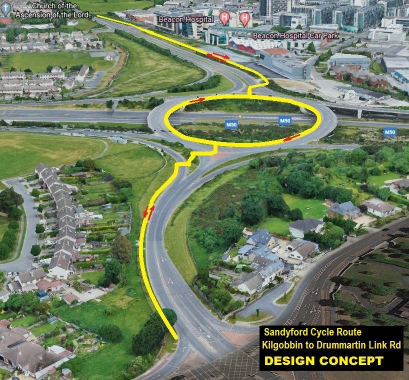
    Some work planned for Kilgobbin road to Dunmartin Link road
    Segregated lane(s) down the hill, across bridge/roundabout above M50, past Beacon to connect up with Sandyford Ind Estate.
    EeBGcT5XkAAaeGY.jpg

    I believe they have completed works this week to widen and segregate the bit along Drunmartin Link Road, where the yellow line currently ends.


  • Advertisement
  • Moderators, Science, Health & Environment Moderators Posts: 19,362 Mod ✭✭✭✭Sam Russell


    Grassey wrote: »
    Some work planned for Kilgobbin road to Dunmartin Link road
    Segregated lane(s) down the hill, across bridge/roundabout above M50, past Beacon to connect up with Sandyford Ind Estate.
    EeBGcT5XkAAaeGY.jpg

    I believe they have completed works this week to widen and segregate the bit along Drunmartin Link Road, where the yellow line currently ends.

    How do cyclist get to the centre of the roundabout?


  • Moderators, Politics Moderators Posts: 38,871 Mod ✭✭✭✭Seth Brundle


    How do cyclist get to the centre of the roundabout?
    In accordance with traditional government policy, we stop at a new stop line, dismount and then whilst pushing the bike, run like feck across the roundabout.


  • Registered Users Posts: 2,393 ✭✭✭Grassey


    How do cyclist get to the centre of the roundabout?

    Haven't looked into the details, but the crossing points are each past traffic lights on the approach roads/roundabout itself.

    So presumably cyclists cross when traffic is stopped to the existing 'path' and follow around to the next lights/crossing.


  • Moderators, Science, Health & Environment Moderators Posts: 19,362 Mod ✭✭✭✭Sam Russell


    Grassey wrote: »
    Haven't looked into the details, but the crossing points are each past traffic lights on the approach roads/roundabout itself.

    So presumably cyclists cross when traffic is stopped to the existing 'path' and follow around to the next lights/crossing.

    That sounds possible. There are only two crossings actually on the roundabout, so maybe.


  • Registered Users Posts: 2,393 ✭✭✭Grassey


    If you look on street view it's the most likely.
    Not the best design, but probably the best that can be done cheap and quick with existing islands and layout.


  • Registered Users Posts: 13,851 ✭✭✭✭Zebra3


    https://www.rte.ie/news/regional/2020/0731/1156673-cycleway-dublin/

    Piece there on the Royal canal cycleway in the city centre.

    Anyone know when the part close to Intel is getting done?


  • Registered Users Posts: 2,393 ✭✭✭Grassey


    I think the west Clare rail greenway can be changed from potential to planned now. Yay more orange!


  • Registered Users Posts: 978 ✭✭✭riddlinrussell


    Grassey wrote: »
    I think the west Clare rail greenway can be changed from potential to planned now. Yay more orange!

    Which one do you mean? The latest batch of funding specifically was for Kilkee to Kilrush? I suppose I can move the whole thing to proposed though!


  • Registered Users Posts: 2,393 ✭✭✭Grassey


    I may have misread this, but I took it to mean that funding was for the first part of the longer route from Ennis?
    The West Clare Railway Greenway project will follow the 85 kilometre route of the old West Clare railway line, where possible, connecting Ennis to Kilrush or Kilkee at a total cost of 20 million euro.

    http://www.clare.fm/news/clare-county-council/e255000-funding-confirmed-west-clare-railway-greenway/


  • Registered Users Posts: 7,811 ✭✭✭Tigerandahalf


    I didn't see that in the initial announcement details.
    There was info on one from Limerick to Scariff.

    Edit: I see it now, 3rd one on the list. It does only say Kilkee to Kilrush on that.


  • Advertisement
  • Registered Users Posts: 1,247 ✭✭✭Greaney


    The Galway to Athlone Greenway Project Office will hold a series of public engagement events in early August 2020 to give members of the public a first opportunity to discuss the greenway design with members of the design team.

    The event details are as follows;
    • Shamrock Lodge Hotel Athlone - Monday 10th August
    • Shearwater Hotel Ballinasloe - Tuesday 11th August
    • Raheen Woods Hotel, Athenry – Wednesday 12th August
    • Loughrea Hotel - Thursday 13th August
    • Maldron Hotel, Oranmore - Friday 14th August.

    All of the events will take place from 11am - 8pm on each day, offering ample opportunity for the public to participate.


  • Registered Users Posts: 3,107 ✭✭✭mr spuckler


    Having been down in Athlone twice in last 3 weeks or so I'm disappointed not to be down to attend this consultation next week. Will be really interested to hear feedback if anyone attends.


  • Registered Users Posts: 8,779 ✭✭✭Carawaystick


    Zebra3 wrote: »
    Anyone know when the part close to Intel is getting done?

    The bit from Intel (the level crossing) to Confey was grand a year ago then Waterways made it not-grand, leaving it full of big chippings and a dog rough surface.
    Theres a big issue with the connections along the canals *just* outside Dublin being sh1te for cycling.

    It's hard to believe at this point that that is just a coincidence..... and not bad faith from WWI


  • Registered Users Posts: 2,393 ✭✭✭Grassey


    Good to see some services development happening too in tandem with route development. With the ringroad to open shortly Sallins should become a bit more enjoyable to stop off in.

    They have also closed the road to cars on the canal between sallins and Naas every Sunday for the next 10 weeks. Looks to have been a load out this weekend, hopefully it evolves into a fulltime green/quiet way

    Development of a “cycle cafe” / bike stop along Grand canal greenway
    Delighted to confirm that Sallins will receive a grant of €25,000 under the July stimulus package towards the development of a “cycle cafe” / bike stop along the canal in village. Building on the greenway funding, this is another vote of confidence in the project and the area. Having seen the success of such ventures on the wild Atlantic way and knowing the great businesses and amenities we have in the village which can integrate with this, I am really excited about this project moving forward.


  • Registered Users Posts: 4,675 ✭✭✭serfboard


    Grassey wrote: »
    They have also closed the road to cars on the canal between sallins and Naas every Sunday for the next 10 weeks. Looks to have been a load out this weekend, hopefully it evolves into a fulltime green/quiet way
    I just "drove" that section there on Google StreetView. There's no reason that section of road shouldn't be closed off to cars completely. There are a couple of houses which need access, but that could be easily provided by alternative routes.


  • Registered Users Posts: 2,393 ✭✭✭Grassey


    Barrier at Abbey Bridge to block cars heading North on the East side, and one at Tandy's on the West side [and one more to the south of the Mills] would preserve local access only quite nicely.


  • Registered Users Posts: 2,393 ✭✭✭Grassey


    Spotted this earlier
    THE ROYAL CANAL GREENWAY - UPDATE

    The Royal Canal runs from Dublin to Longford with a total distance of 146 kilometres. The Royal Canal Greenway will be a dedicated off-road cycling and walking route along the Royal Canal including paving, landscaping, art works and a viewing plaza of the Canal. CCTV and lighting will also be installed along the route.

    DUBLIN CITY SECTION OF GREENWAY:

    The Dublin city section of the greenway will provide a high quality walking and cycling route of over 7km from the Samuel Beckett Bridge and Guild Street in the Docklands, through North Strand, Drumcondra and Phibsborough and out to Ashtown.

    CURRENT STATUS:

    Phase 1: Guild Street to Upper Sheriff Street (0.5 Km) – Completed in 2009.

    Phase 2: Upper Sheriff Street to North Strand (0.7km) – Completed July 2020

    Phase 3: North Strand to Phibsborough, (2.1km) – Detailed design phase. It is expected that construction will begin at the end of Quarter 4 in 2020 and it will take approximately two years to complete.

    Phase 4: Cross Guns Bridge, Phibsborough to Longford Bridge, Ashtown (4.3Km) - This project has 4 sub-phases.

    Phase 4A involves the introduction of a contra-flow bus and cycle lane over Broome Bridge in Cabra - It is currently in construction and it will be completed by October 2020.

    Phase 4B involves main towpath upgrade - It is anticipated that construction will commence in Quarter 4 of 2020, with likely completion in Quarter 4
    of 2021. Dredging of the canal will be required for some sections.

    Phase 4C involves remainder of towpath upgrade, including 7th Lock/Liffey Junction railway underpass upgrade
    AND
    Phase 4D (Tolka Valley Park –
    Phoenix Park greenway link via Ashtown) are currently in the design stage - A
    timeline for the completion of 4C and 4D sub-phases is not possible at present. However, it is hoped that all of Phase 4 of the Royal Canal Greenway will be completed by the end of 2023.

    Cllr. Colm O’Rourke
    colm.orourke@dublincity.ie


  • Posts: 0 [Deleted User]


    Grassey wrote: »
    Phase 3: North Strand to Phibsborough, (2.1km) – Detailed design phase. It is expected that construction will begin at the end of Quarter 4 in 2020 and it will take approximately two years to complete.

    What explains why it will take 2 years to build 2.1km of a greenway?


  • Advertisement
  • Registered Users Posts: 2,393 ✭✭✭Grassey


    What explains why it will take 2 years to build 2.1km of a greenway?

    Not sure, a quick google just throws up 2 ramps and several protected structures.


    PHASE 3: NORTH STRAND ROAD, DUBLIN 1 TO PHIBSBOROUGH ROAD, DUBLIN 7.
    The proposed works shall comprise the construction of c.2.1km cycle and pedestrian route from North Strand Road (Newcomen Bridge – Protected Structure) to Phibsborough Road. The route shall traverse past Clarke’s Bridge and Binns Bridge, both Protected Structures.

    Toucan (pedestrian and cycle) crossings shall be provided at the following locations:

    North Strand Street / Newcomen Bridge; Summerhill Parade / Clarke’s Bridge; Russell Street / Russell Street Bridge; Drumcondra Road Lower / Binn’s Bridge; Phibsborough Road / Cross Guns Bridge. Two new pedestrian/cycle bridges and associated ramps are proposed to facilitate the route at Croke Park south east of Russell Street and at the 3rd Royal Canal Lock.


Advertisement