Advertisement
If you have a new account but are having problems posting or verifying your account, please email us on hello@boards.ie for help. Thanks :)
Hello all! Please ensure that you are posting a new thread or question in the appropriate forum. The Feedback forum is overwhelmed with questions that are having to be moved elsewhere. If you need help to verify your account contact hello@boards.ie
Help Keep Boards Alive. Support us by going ad free today. See here: https://subscriptions.boards.ie/.
If we do not hit our goal we will be forced to close the site.

Current status: https://keepboardsalive.com/

Annual subs are best for most impact. If you are still undecided on going Ad Free - you can also donate using the Paypal Donate option. All contribution helps. Thank you.
https://www.boards.ie/group/1878-subscribers-forum

Private Group for paid up members of Boards.ie. Join the club.

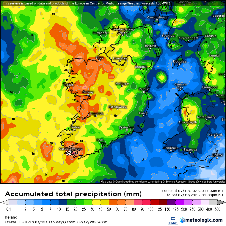
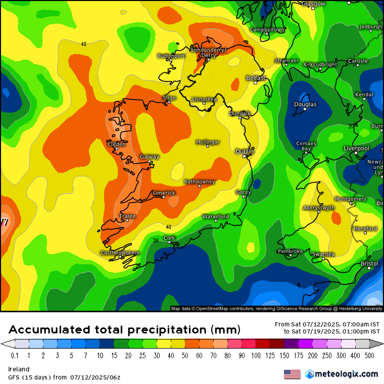
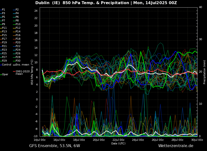
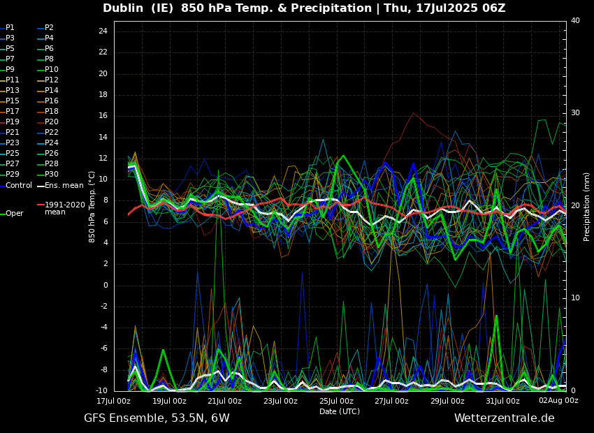
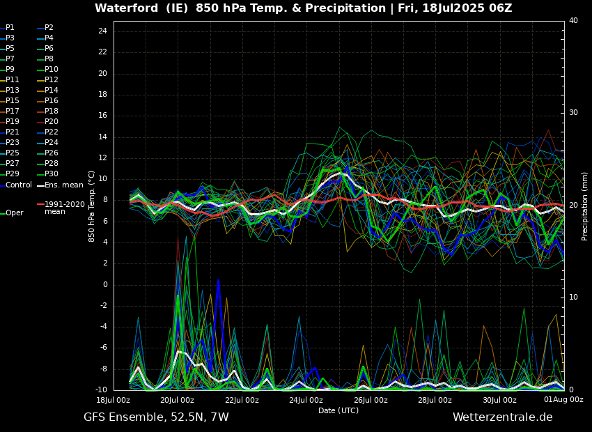
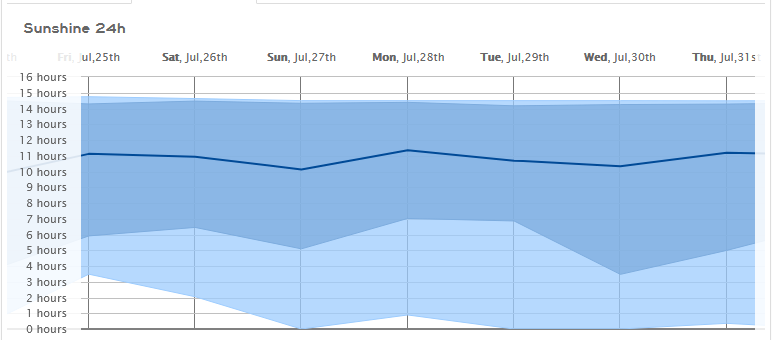
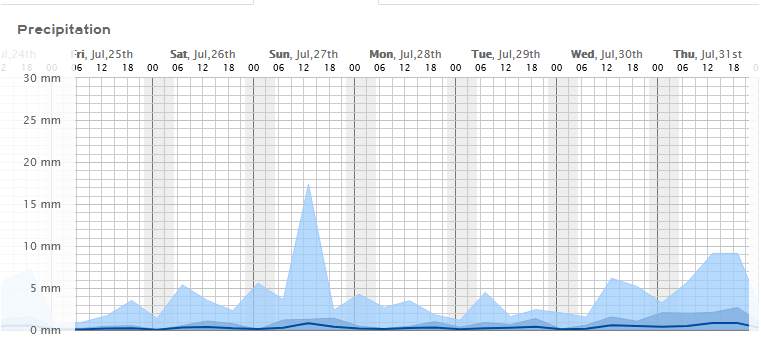
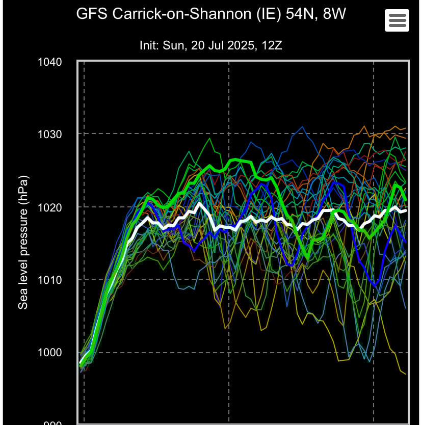
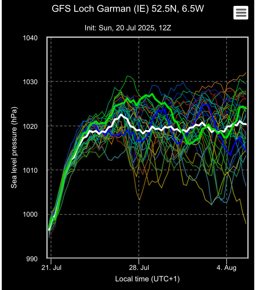
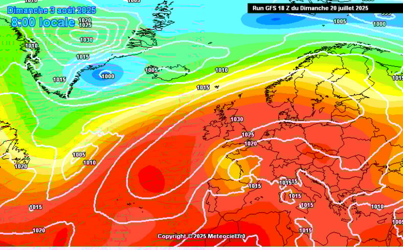
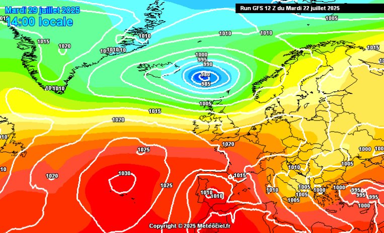
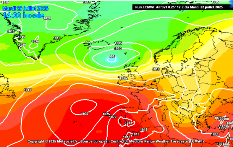
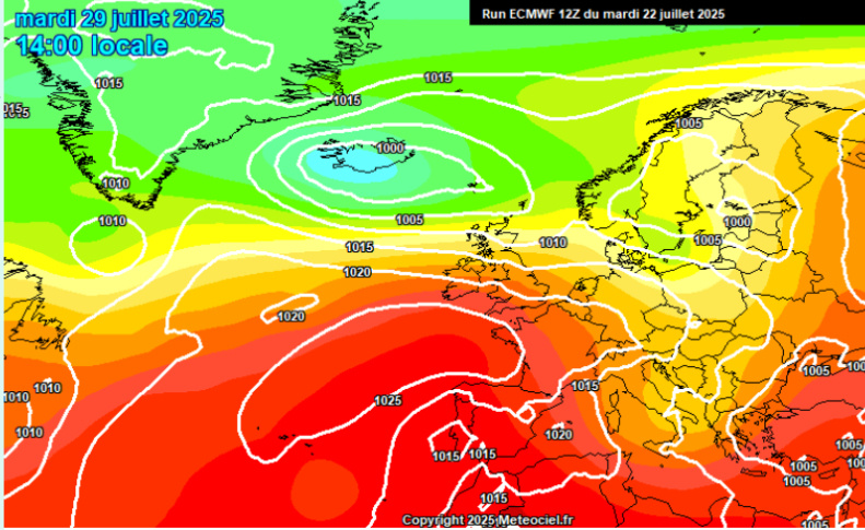
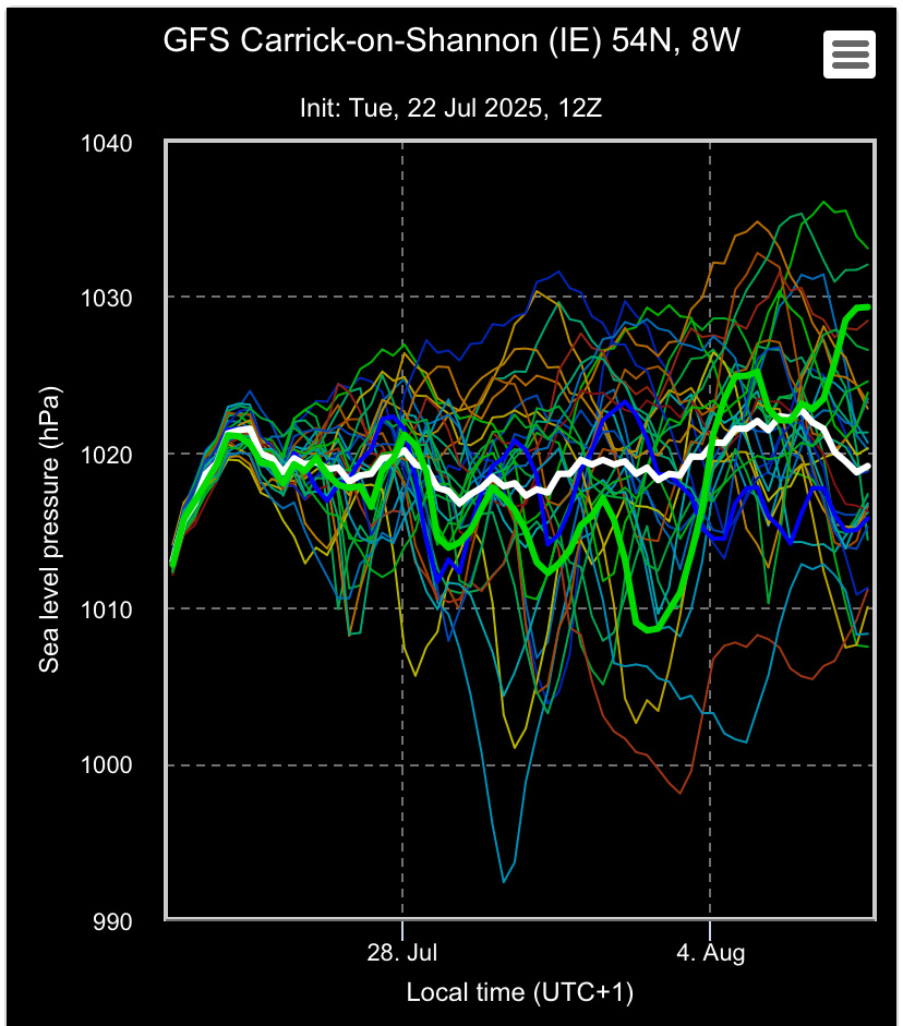
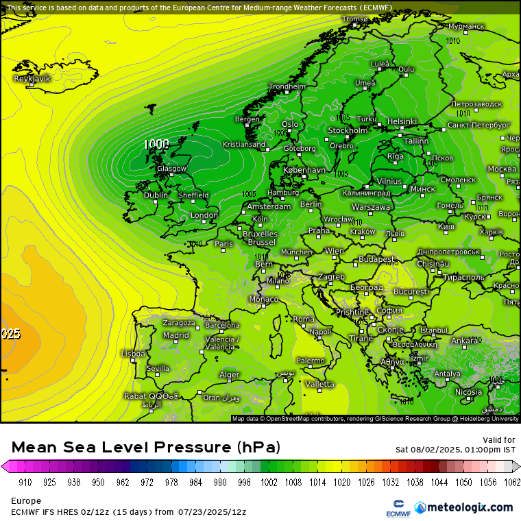
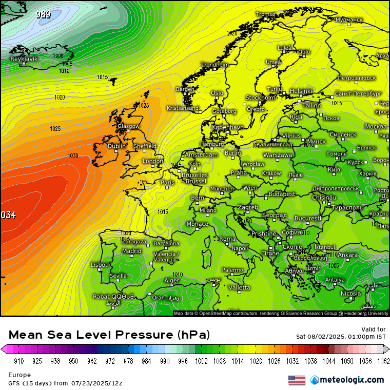
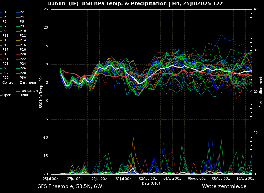
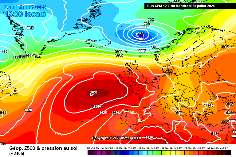
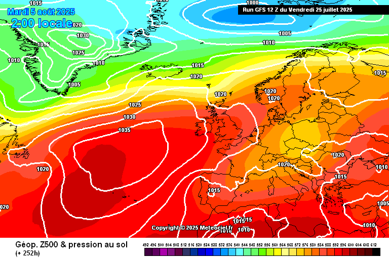
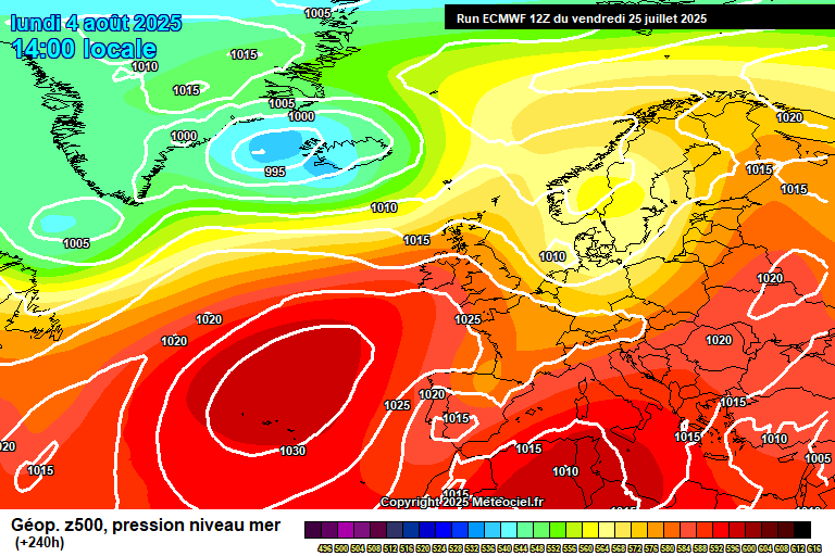
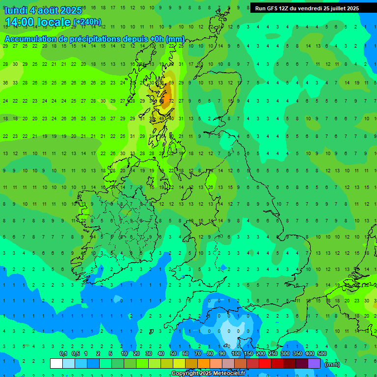
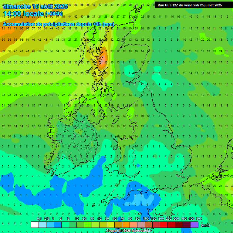
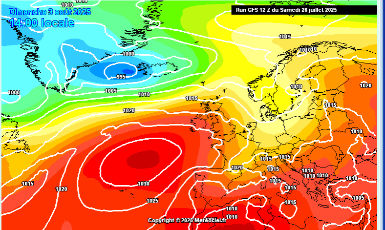
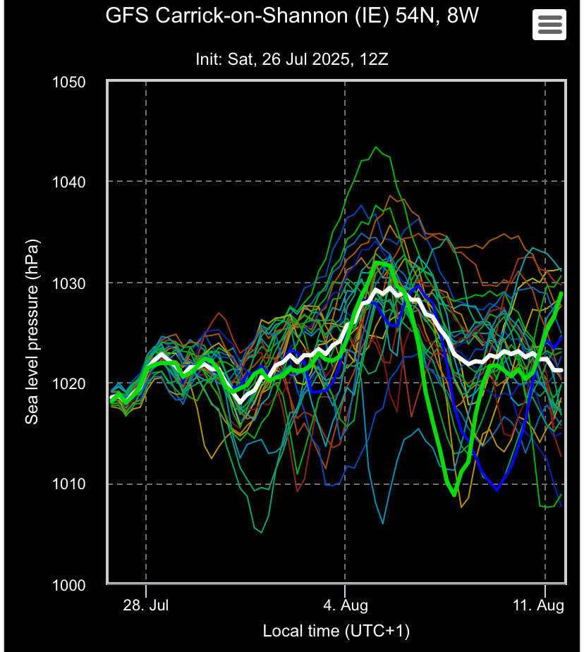
FI Charts ( T120+ onwards) Summer 2025 **READ MOD NOTE IN FIRST

16791112

Comments

  • Registered Users, Registered Users 2 Posts: 5,070 ✭✭✭beggars_bush


    The area of Galway, Mayo, Donegal combined is almost the area of Leinster


  • Registered Users, Registered Users 2 Posts: 2,200 ✭✭✭adocholiday


    I posted this in the general chat but the accumulated totals between now and this time next week are similar on both GFS and ECM. It's not just heavy thundery showers making up these totals either. Monday is maybe more showery but Tuesday and Thursday it's looking like lighter, persistent rain and Friday is looking like heavy persistent rain in late afternoon (based on current models).

    xx_model-en-324-0_modez_2025071200_180_949_157.png xx_model-en-324-0_modusa_2025071206_174_949_157.png


  • Moderators, Science, Health & Environment Moderators Posts: 17,796 Mod ✭✭✭✭Gonzo


    A very zonal westerly setup looks certain for the remainder of July with average or slightly cooler than average temperatures and plenty of rain or showers. The GFS 00z has a lovely Azores high sitting over us by the end but this is very much an outlier. Hopefully within the next week we will see another spell of 3 to 4 settled days developing before the end of July.

    image.png


  • Moderators, Science, Health & Environment Moderators Posts: 17,796 Mod ✭✭✭✭Gonzo


    GFS 6z again very similar to the 00z and pumps out the most extreme outlier for the operational run with a heat plume right at the end.


  • Registered Users, Registered Users 2 Posts: 195 ✭✭odyboody


    Really shows the of looking at only Op run, the control is nearly a mirror image


  • Advertisement
  • Moderators, Science, Health & Environment Moderators Posts: 17,796 Mod ✭✭✭✭Gonzo


    models today for the rest of July don't look quite as bleak as yesterdays, perhaps a trend of an improving situation later next week.


  • Registered Users, Registered Users 2 Posts: 3,773 ✭✭✭Dazler97


  • Registered Users, Registered Users 2 Posts: 7,617 ✭✭✭pauldry


    Weather this Summer isn't near as bad as last Summer temp wise at least. A lot of thunderstorms in the coming days. Warm sunshine too so over 20c in most places. A moderate risk of drier weather next week with similar temperatures but the evolving low of this week could yet slow down and delay the azores high further.


  • Moderators, Science, Health & Environment Moderators Posts: 17,796 Mod ✭✭✭✭Gonzo


    This mornings models don't give much comfort of an improving situation any time soon. Looks relatively cool and very unsettled right up to 2nd of August with a north-west to south-east alignment of the jetstream right over us and the Azores staying well to the south.


  • Moderators, Science, Health & Environment Moderators Posts: 17,796 Mod ✭✭✭✭Gonzo


    image.png

    Not the sort of ensemble you want to be seeing in the middle of Summer, an overall cooling trend and things staying wet and unsettled from start to finish. Once we get the warmish air out of the way by Saturday we're into a cool north-westerly pancake flow from the Atlantic for the forseeable future. I hope we see a more positive change develop next week, that this isn't summer going down the tubes.


  • Advertisement
  • Registered Users, Registered Users 2 Posts: 3,194 ✭✭✭dominatinMC


    Historically, August wouldn't fill you with confidence. It was good while it lasted folks.


  • Registered Users, Registered Users 2 Posts: 6,138 ✭✭✭TheMilkyPirate


    August Bank Holiday looking lovely on the models this morning dry and temps well into the 20s if its any consolation.


  • Registered Users, Registered Users 2, Paid Member Posts: 1,366 ✭✭✭Sammy2012


    I'm going to take with this. We were away at the beginning of July and brought home some lovely weather and we are going away next week and back for the bank holiday weekend so planning on bringing it back again.


  • Moderators, Science, Health & Environment Moderators Posts: 17,796 Mod ✭✭✭✭Gonzo


    The August Bank Holiday does look lovely on the 00z, however the operational run and indeed the control are kinda outliers, but maybe they are on to something, far too early to tell yet. It's almost 2 weeks away therefore in the highly unreliable timeframe.


  • Registered Users, Registered Users 2 Posts: 413 ✭✭brookers


    Is it all bad all over Ireland? YR giving Rosslare area 17 degrees and 18 sunny……for next week?


  • Moderators, Science, Health & Environment Moderators Posts: 17,796 Mod ✭✭✭✭Gonzo


    I don't really place much value on these automated sites, even Met Eireann's one yesterday was very wrong about temperatures, 22C instead of 18C and rain when it's sunny and sunny when it's raining etc etc. Looking at models certainly gives a better idea of what might be in store compared to reading off an automated site like YR or accuweather etc.


  • Registered Users, Registered Users 2 Posts: 413 ✭✭brookers


    So you think from the models that it won't be great…….in the sunny south east.


  • Moderators, Science, Health & Environment Moderators Posts: 17,796 Mod ✭✭✭✭Gonzo


    For the sunny south-east the next few days don't look all that sunny.

    image.png

    A good chance of rain over the next few days up until the 22nd of July. After that we are into the unreliable timeframe so alot of scatter in the models. However the one change I see in the unreliable timeframe is a move to dryer conditions. The 00z and all of yesterdays output was definitely wetter than this from start to finish. There is also a hint that temperatures may pick up briefly between the 24th and 26th of June, possibly early signs of a brief push of warm air again.


  • Registered Users, Registered Users 2 Posts: 2,200 ✭✭✭adocholiday


    I don't know Gonzo, ECM is going for decent amounts of sunshine for the SE all this week and next week. GEM is backing that up too. It won't be clear blue skies for sure, there's plenty of precipitation in the coming week but the following week looks relatively dry with plenty of sunny spells (using Rosslare as location here).

    The dark blue line here is the average of the ECM ensembles showing approx. 11 hours of sunshine per day for next weekend and beyond, and the second graph showing little amounts of precipitation for the same period. This is specific to Rosslare though, the rest of the country could be completely different.

    image.png image.png


  • Moderators, Science, Health & Environment Moderators Posts: 17,796 Mod ✭✭✭✭Gonzo


    That's very different to the GFS so which model is correct!


  • Advertisement
  • Moderators, Science, Health & Environment Moderators Posts: 1,624 Mod ✭✭✭✭WolfeEire
    Clare (430ft asl)


    Looking more settled from mid week next week through the weekend. Generally changeable up to then.

    www.weatheire.com


  • Registered Users, Registered Users 2 Posts: 385 ✭✭Ros4Sam24


    A definite trend towards higher pressure from mid week, best farther south and east but not bad nationwide. Tentative signs towards this being a longer lasting spell of more settled weather for the south at least, from this flexing Azores ridge.

    IMG_0754.jpeg IMG_0755.jpeg IMG_0753.jpeg

    Gfs 18z is very August 22 esque. One of my favourite months of all time.


  • Registered Users, Registered Users 2 Posts: 3,773 ✭✭✭Dazler97


    I hope the long term models are looking good fingers crossed 🤞 I know August tends to be the wettest summer month but hopefully we get some more warmth 😊


  • Registered Users, Registered Users 2 Posts: 385 ✭✭Ros4Sam24


    The models today are following the trend of the last 36 hours… Flat

    Ecmwf, Ecm ai and Gfs are largely similar at day 7

    IMG_0758.jpeg IMG_0757.jpeg IMG_0756.jpeg

    The ECM makes the most of the Azores high giving more settled weather further south, but still not much good for the North which has a low near Iceland. This low is seen on all three op runs.

    The Gfs ensembles are ok with a fair amount of runs bringing the Azores ridge further North next week.

    IMG_0760.jpeg IMG_0761.jpeg

    These locations Carrick on Shannon and Wexford, are indicative of a North/ South split, similar to what was often seen this June.

    All and all it’s an alright outlook, certainly nothing special but not a washout. Hopefully we see the trend we had a few days ago return with more influential high pressure. ☀️ ☀️


  • Registered Users, Registered Users 2 Posts: 3,773 ✭✭✭Dazler97


    thank you ☺️ was dying to see what models looked like long term , seems good at present if all models have a similar outlook


  • Registered Users, Registered Users 2 Posts: 2,200 ✭✭✭adocholiday


    First time looking at the model runs for a bit and it's not looking great for the bank holiday on ECM. The next week looks decent but nothing special. Drier at least but temperatures just about getting to 20 in places and cloud aplenty. ECM showing a low pressure system over us for most of the long weekend though with no shortage of rain. GFS wants to bring some of the Azores high our way but given our August trends and ECM being the form horse I'd be leaning towards that for the moment. Hopefully the outcome improves during the week.

    xx_model-en-324-0_modez_2025072312_240_1642_149.png xx_model-en-324-0_modusa_2025072312_240_1642_149.png


  • Registered Users, Registered Users 2 Posts: 190 ✭✭ClimateObserver


    Looking at model outputs and it seems most are in agreement until the Bank Holiday Weekend. The pressure gradient overall looks very slack westerly throughout the next week or so resulting in quite light winds generally - though the northwest coastal areas could see breezier spells as fronts pass to the north. This means we will feel the benefit of the temperatures which for almost all of the days will get to the low 20s. Cloud cover will come and go throughout - so a pretty non-descript but pleasant enough spell of weather coming up.


  • Moderators, Science, Health & Environment Moderators Posts: 17,796 Mod ✭✭✭✭Gonzo


    definitely a bit of a warming trend starting to appear on the GFS for late July into the first week of August. I hope the models so not backtrack on this with high pressure possibly becoming more dominant in about a weeks time. Overall a relatively dry graph, only light rain or showers here and there.

    image.png gem-0-240.png gfs-0-252.png ECM1-240.GIF

    10 days out and not much rainfall over the next week and a half

    240-777UK.GIF

    Over 2 weeks away and rainfall totals barely change.

    384-777UK.GIF

    Could we be in for a very good first week of August including the bank holiday weekend? Time will tell but so far looking promising. This would make a very positive change for the start of August.


  • Registered Users, Registered Users 2 Posts: 385 ✭✭Ros4Sam24


    Another steady day from the models with high pressure in our vicinity as we head towards the last month of meteorological summer.

    This week the high will be just a small bit out of touch to keep things totally settled but not a whole lot of rain to come for most with the Nw the most changeable.

    Unusually there is quite a bit of confidence for the huge area of high pressure to move closer, settling things down further.

    IMG_0766.jpeg

    Some Gfs ensemble members go off the walls with the high and break our August high pressure record, which stands at 1036hpa.

    IMG_0765.jpeg

    With all this high pressure we could likely see heat build day on day, especially if the high continues its journey east.

    IMG_0767.jpeg


    All and all a decent week of weather coming up with the potential for a lovely first half of August more than alive.☀️☀️


  • Advertisement
  • Registered Users, Registered Users 2 Posts: 3,773 ✭✭✭Dazler97


    that’s looking positive anyway if we can still see this by Wednesday then it can almost be set in stone fingers crossed 🤞


This discussion has been closed.
Advertisement