Advertisement
If you have a new account but are having problems posting or verifying your account, please email us on hello@boards.ie for help. Thanks :)
Hello all! Please ensure that you are posting a new thread or question in the appropriate forum. The Feedback forum is overwhelmed with questions that are having to be moved elsewhere. If you need help to verify your account contact hello@boards.ie

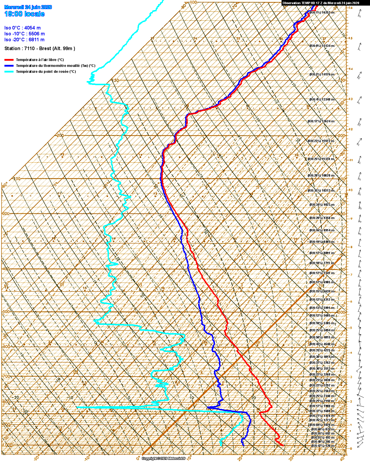
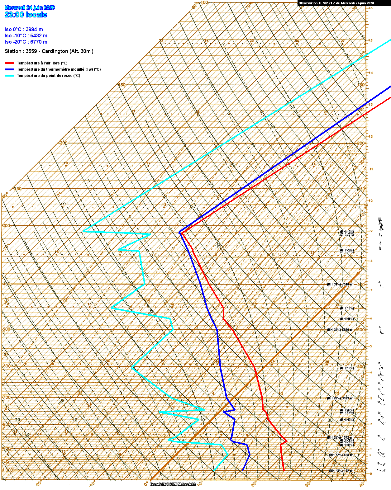
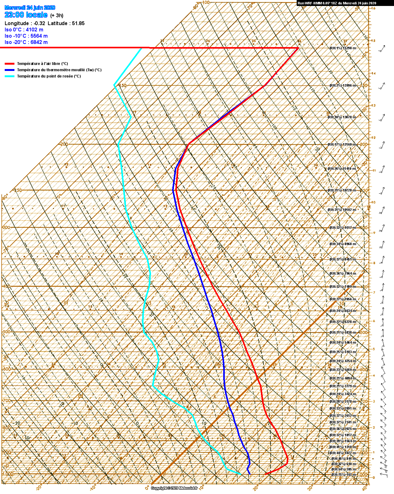
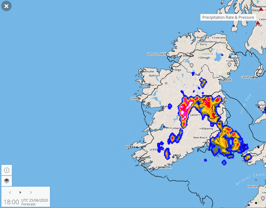
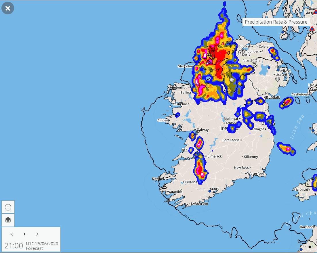
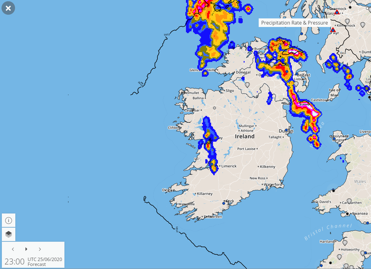
Thursday/Friday: Lightning Storms, Flash Flooding Event Thread

  • 24-06-2020 10:06PM
    #1
    Registered Users, Registered Users 2 Posts: 25,247
    ✭✭✭✭


    icon4.png


    Could be a memorable event tomorrow evening and overnight for many and deserves it's own thread.

    It should all kick off around early afternoon with elevated storms developing in the southeast, from then on the atmosphere gets ever more unstable and storms breaking out widely through the evening with increasing intensity leading to spectacular scenes for some.

    Most places can expect to see lightning either over head or in the distance but perhaps midlands and northwest might go a little beyond the storms elsewhere in terms of intensity.

    We'll be keeping an eye on potential multi-cellular storm development too which is possible and could enhance conditions just about anywhere in the at risk zones.

    National warning is currently yellow

    Thursday evening until Friday sunrise are peak conditions

    icon4.pngicon4.png

    Areas most at risk:

    East Connaught, Leinster, Ulster and East Munster

    Warning of disruption:

    Lightning, flash flooding

    Irritant warning:

    "I can't sleep"

    Hot tomorrow in places with temperatures up to 28c, highest in the eastern half of the country.


    Keep an eye on the storm thread for more technical discussion

    https://www.boards.ie/vbulletin/showthread.php?t=2058058601&page=114

    yOTfBfd.gif?noredirect


Welcome!

It looks like you're new here. Sign in or register to get started.
«13456730

Comments

  • Registered Users, Registered Users 2 Posts: 6,594 munsterlegend
    ✭✭✭


    Kermit do you mean East Munster instead of West Munster? Would make more sense.


  • Registered Users, Registered Users 2 Posts: 25,247 Kermit.de.frog
    ✭✭✭✭


    Kermit do you mean East Munster instead of West Munster? Would make more sense.

    ha! Yes :pac:


  • Registered Users, Registered Users 2 Posts: 2,339 The One Doctor
    ✭✭✭


    I would dearly love to see an MCS again. It's an awesome sight.

    Fully prepared for this to be a total flop though.


  • Registered Users, Registered Users 2 Posts: 25,247 Kermit.de.frog
    ✭✭✭✭


    Fully prepared for this to be a total flop though.

    :eek:


  • Registered Users, Registered Users 2 Posts: 227 diceyd
    ✭✭


    So Liverpool could be crowned champions tomorrow with thunderstorms outside, if Carlsberg did Thursdays.......


  • Advertisement
  • Registered Users, Registered Users 2 Posts: 8,261 Gaoth Laidir
    ✭✭✭


    This this evening's radiosonde from Brest, NW France, the source of tomorrow evening's airmass up along the east coast. Strongly capped, with no SBCAPE and only slight MUCAPE from around 850-900 hPa. Uplift from the upper trough will be needed to cool upper lapse rates and overcome the cap tomorrow.

    Surface dewpoints in the region are currently in the range 16-18 °C. I would say this will be the max we will acheive tomorrow too.

    7110_0_2006241706.png

    517664.png


  • Registered Users, Registered Users 2 Posts: 25,247 Kermit.de.frog
    ✭✭✭✭


    Things look to be a lot juicier by tomorrow evening.

    Quite the opportunity to exploit, very rarely do we get this potential.

    nmmuk-6-23-0.png?24-23

    21-109UK.GIF?24-18

    24-101UK.GIF?24-18


  • Registered Users, Registered Users 2 Posts: 48,462 km79
    ✭✭✭✭


    Looks like mayo is going to miss all the “fun” !


  • Registered Users, Registered Users 2 Posts: 25,547 Larbre34
    ✭✭✭✭


    diceyd wrote: »
    So Liverpool could be crowned champions tomorrow with thunderstorms outside, if Carlsberg did Thursdays.......

    And they knock out the satellite telly....?


  • Registered Users, Registered Users 2 Posts: 316 chris2007
    ✭✭


    Is Dublin in the firing line


  • Advertisement
  • Registered Users, Registered Users 2 Posts: 8,261 Gaoth Laidir
    ✭✭✭


    The next frame in the WRF MUCAPE map is completely off the wall and totally unrealistic.

    nmmuk-28-25-0_jwz3.png


  • Registered Users, Registered Users 2 Posts: 25,247 Kermit.de.frog
    ✭✭✭✭


    chris2007 wrote: »
    Is Dublin in the firing line

    Yes, very much so.

    With the hit and miss proviso given the nature of showery pulses. But you have a very big chance of seeing lightning either overhead or close at some point over the next 36 hours.


  • Registered Users, Registered Users 2 Posts: 25,547 Larbre34
    ✭✭✭✭


    chris2007 wrote: »
    Is Dublin in the firing line

    Yep.

    But unlike anything else; snow, frontal rain, wind storms, a few kilometres either way could make a massive difference.


  • Registered Users, Registered Users 2 Posts: 25,547 Larbre34
    ✭✭✭✭


    chris2007 wrote: »
    Is Dublin in the firing line

    Yep.

    But unlike anything else; snow, frontal rain, wind storms, a few kilometres either way could make a massive difference.


  • Closed Accounts Posts: 395 Class MayDresser
    ✭✭


    Gonna miss Starlink launch so :-(


  • Registered Users, Registered Users 2 Posts: 6,056 Storm 10
    ✭✭✭


    Jez lads if this was going to happen in the West we just get on with it, anything happening in the East goes into overdrive.


  • Moderators, Science, Health & Environment Moderators Posts: 17,436 Gonzo
    Mod ✭✭✭✭


    nmmuk-6-26-0.png?24-23

    that chart is just insane, it's just not possible. If that came off we would probably be looking at possible 1985 territory which is a once in a lifetime event.

    Being realistic we will end up with something similar to last week's event, maybe a few places getting something similar to the Wexford/Waterford storm recently.


  • Registered Users, Registered Users 2 Posts: 2,935 sparrowcar
    ✭✭✭


    Storm 10 wrote: »
    Jez lads if this was going to happen in the West we just get on with it, anything happening in the East goes into overdrive.

    Would you stop the thread was lit up here recently when the west had its own shows.

    Anyway this looks special, not the handful of sparks you had down there.


  • Registered Users, Registered Users 2 Posts: 7,324 pad199207
    ✭✭✭


    Huge drops of rain in Kildare :O


  • Registered Users, Registered Users 2 Posts: 25,247 Kermit.de.frog
    ✭✭✭✭


    Gonzo wrote: »
    nmmuk-6-26-0.png?24-23

    that chart is just insane, it's just not possible. If that came off we would probably be looking at possible 1985 territory which is a once in a lifetime event.

    Being realistic we will end up with something similar to last week's event, maybe a few places getting something similar to the Wexford/Waterford storm recently.

    468n6e.jpg


  • Advertisement
  • Registered Users, Registered Users 2 Posts: 8,261 Gaoth Laidir
    ✭✭✭


    Just comparing those crazy WRF-005 charts with actual observations.

    There was a radiosonde launch fromo Cardington, near Stansted, at 21Z this evening (first plot). Second plot is the 18Z WRF forecast sounding for the same time.

    The WRF completely gets low-level moisture wrong, with dewpoint at least 5 degrees too high, and this is just a 4-hour forecast. It also gets the boundary layer temperature arseways, showing way too much cooling. Otherwise it gets upper levels fairly well, apart from missing out several moist layers at mid-levels.

    It would appear that this model, which is fed by the GFS, doesn't have a grip on the boundary layer conditions and is the reason why it's showing ridiculously high CAPE and LI values for tomorrow (and even this evening in much of central and NW England (shown below), where skies are clear. Use this model at your peril.

    3559_0_2006242106.png

    sondagewrf_300_123_3_0_1593040617.png

    517668.png


  • Registered Users, Registered Users 2 Posts: 415 SlowMotion321
    ✭✭


    sounds like it will be a fun show, we rarely get anything like that in the east, the only big storms i have seen were in other countries


  • Registered Users, Registered Users 2 Posts: 2,133 I says
    ✭✭✭


    Will I leave the dog in or out so


  • Registered Users, Registered Users 2 Posts: 18,489 JCX BXC
    ✭✭✭✭


    I says wrote: »
    Will I leave the dog in or out so

    When?


  • Registered Users, Registered Users 2 Posts: 2,133 I says
    ✭✭✭


    JCX BXC wrote: »
    When?

    What’s that old wives tale about dogs and thunder and lightning storms.


  • Registered Users, Registered Users 2 Posts: 1,788 Bsal
    ✭✭✭


    UKMO forecast

    18z
    c0299d31d3867b3d1be659807ac1f995.png

    21z
    a92db5409c6378c21a1214fdb74e69dc.png

    Then by midnight in the Irish Sea

    a54217538e9cc87e8de1c0895ffc9011.png


  • Registered Users, Registered Users 2 Posts: 126 zisdead
    ✭✭


    Estofex just out and has pretty much all of Leinster along with East Munster and East Ulster under a Level one for Severe thunderstorms

    http://www.estofex.org/

    "A level 1 was issued across northern Spain and northern Portugal across the Bay of Biscay into the south-western British Isles mainly for large hail and severe wind gusts."


  • Registered Users, Registered Users 2 Posts: 2,855 Nabber
    ✭✭✭


    It's the sparks people really wann see tho

    showforecast.cgi?lightningmap=yes&fcstfile=2020062606_202006250036_1_stormforecast.xml


  • Registered Users, Registered Users 2 Posts: 25,247 Kermit.de.frog
    ✭✭✭✭


    A small storm getting going 100 miles west of Brest in north west France at the moment, sferics going - moisture moving up from Biscay.

    A good sign for instability for us later on.

    It will be a good start to the day in the eastern half of the country with beautiful sunshine and helping temperatures rise.


  • Advertisement
  • Registered Users, Registered Users 2 Posts: 7,324 pad199207
    ✭✭✭


    Stunning sunrise

    Met Eireann have really toned down the forecast for today and tonight. Honestly sounds like a downgrade.


Welcome!

It looks like you're new here. Sign in or register to get started.
Advertisement