Advertisement
If you have a new account but are having problems posting or verifying your account, please email us on hello@boards.ie for help. Thanks :)
Hello all! Please ensure that you are posting a new thread or question in the appropriate forum. The Feedback forum is overwhelmed with questions that are having to be moved elsewhere. If you need help to verify your account contact hello@boards.ie

Thursday/Friday: Lightning Storms, Flash Flooding Event Thread

1246730

Comments

  • Registered Users, Registered Users 2 Posts: 5,164 ✭✭✭Comhrá


    Rookie question -

    What sort of clouds should I be looking out for? Don’t want to be searching skies to my south when the action is building in the north.

    This sort of thing. Can't miss them really:

    XpOhjBWl.jpg

    x9wE8AOl.jpg


  • Registered Users, Registered Users 2 Posts: 1,125 ✭✭✭greenfield21


    I hope we are all looking out at the Irish sea at what could of been. Prefer a nice calm night.


  • Registered Users, Registered Users 2 Posts: 420 ✭✭Little snowy old me


    What's with the toning down of Met Eireann's forecast? Please don't tell me this is not going to happen. I have been looking forward to it since yesterday. I don't need more disappointment.


  • Registered Users, Registered Users 2 Posts: 485 ✭✭KingdomRushed


    What's with the toning down of Met Eireann's forecast? Please don't tell me this is not going to happen. I have been looking forward to it since yesterday. I don't need more disappointment.

    The toning down is probably based on their model assessments which maybe show less widespread storms than previously forecast. The toning down of language is reflected in their rainfall maps.


  • Moderators, Home & Garden Moderators, Science, Health & Environment Moderators Posts: 18,908 Mod ✭✭✭✭DOCARCH


    What's with the toning down of Met Eireann's forecast? Please don't tell me this is not going to happen. I have been looking forward to it since yesterday. I don't need more disappointment.

    Expect nothing and then you will not be disappointed.


  • Advertisement
  • Registered Users, Registered Users 2 Posts: 485 ✭✭KingdomRushed


    I've attached a screen grab of peak activity as shown on met website. No longer shows any precipitation for east coast for next 24 hours. Northwest is in firing line for a storm according to this, but not until after midnight. No activity showing for eastern Ireland anymore. Let's see if it is right. Yesterday morning it showed widespread very heavy precipitation over large parts of ireland.


  • Registered Users, Registered Users 2 Posts: 2,243 ✭✭✭squarecircles


    the damp squids

    cant wait to piss all of this thread later,regardless of what materialises,like people did with the storms in the west last week.


  • Posts: 133 ✭✭ [Deleted User]


    Am I right in saying this is a non event for the SW.


  • Registered Users, Registered Users 2 Posts: 12,881 ✭✭✭✭average_runner


    DOCARCH wrote: »
    Expect nothing and then you will not be disappointed.


    We don't need the weather forum so:eek::D


  • Closed Accounts Posts: 1,220 ✭✭✭Davaeo09


    lovely morning here in kilkenny

    very warm already


  • Advertisement
  • Registered Users, Registered Users 2 Posts: 8,261 ✭✭✭Gaoth Laidir


    Don't be focusing too much on precipitation forecasts as rainfall can sometimes evaporate before reaching the ground with elevated storms.

    Met Éireann's aviation chart for 12Z shows an area C covering all of Ireland and extending southeastwards down over Land's End and NW France. A trough is shown over Brest, moving northwestwards at 30 knots.

    Weather description for this area is as follows:

    Generally fine, but isolated (occasional near troughs) heavy showers/thunderstorms with hail, Cb bases 3000-6000 ft, and isolated coastal fog.


  • Registered Users, Registered Users 2 Posts: 837 ✭✭✭bazlers


    Meteorite58 will come in with a haymaker of a prediction soon and the rollercoaster goes up again ;)


  • Registered Users, Registered Users 2 Posts: 2,194 ✭✭✭John.Icy


    the damp squids

    cant wait to piss all of this thread later,regardless of what materialises,like people did with the storms in the west last week.

    Are you well?

    Pretty much everyone looked on in envy of the storms last week out West. There was no pissing all over the thread, widespread acknowledgement of how incredible some of those storms seemed.

    Your continued anger on this forum towards people in the East is frankly weird. It's just weather. Lighten up.


  • Registered Users, Registered Users 2 Posts: 5,164 ✭✭✭Comhrá


    Am I right in saying this is a non event for the SW.

    Sadly I'd say you're right. In years of watching this sort of set-up with a humid southeasterly flow and our proximity to the Atlantic, I can't really ever recall significant thunderstorms developing in the Southwest of the country. At best, storms usually develop no further west than the Limk/ Tipp border. Maybe an isolated cell may pop up somewhere west of that line, but that's the most I'd expect.

    These storms from Spanish plumes usually run east of a line from say, Waterford to east Mayo so west Munster will miss out as usual. Hope I'm wrong though!


  • Registered Users, Registered Users 2 Posts: 24,752 ✭✭✭✭lawred2


    gorgeous morning here in North County Dublin

    What time is this weather change?


  • Registered Users, Registered Users 2 Posts: 2,339 ✭✭✭The One Doctor


    lawred2 wrote: »
    gorgeous morning here in North County Dublin

    What time is this weather change?

    8-10pm and on.


  • Registered Users, Registered Users 2 Posts: 24,752 ✭✭✭✭lawred2


    8-10pm and on.

    grand - should get a full day out of this sun then


  • Posts: 133 ✭✭ [Deleted User]


    Davaeo09 wrote: »
    lovely morning here in kilkenny

    very warm already

    Where else would people moan about something they can't control.

    Overcast day in North Kerry. 19.2C
    998 hpa. NNE wind 1.7 m/s


  • Banned (with Prison Access) Posts: 302 ✭✭Muscles Schultz


    The question needed to be asked - I’m driving from Dunmore East at 8pm to Dublin Airport to take a flight to Kerry to collect a dog for my one legged mother.....will it be safe to do so?


  • Registered Users, Registered Users 2 Posts: 6,044 ✭✭✭Storm 10


    Hate to throw a spanner in the works

    From Met Eireann


    Tonight will be very mild and humid, with further scattered heavy and
    thundery downpours and with a risk of hail and spot flooding. The risk of
    thunderstorms is greatest in Ulster and Connacht


  • Advertisement
  • Closed Accounts Posts: 1,220 ✭✭✭Davaeo09


    Storm 10 wrote: »
    Hate to throw a spanner in the works

    how has it moved so far north?


  • Registered Users, Registered Users 2 Posts: 24,752 ✭✭✭✭lawred2


    Storm 10 wrote: »
    Hate to throw a spanner in the works

    Saw BBC weather earlier that had some sort of concentrated cell hitting east coast directly... Dublin was bang in the middle.

    Didn't seem to go near Connacht


  • Registered Users, Registered Users 2 Posts: 6,044 ✭✭✭Storm 10


    Seems to be showers developing to the South West

    http://www.raintoday.co.uk/


  • Registered Users, Registered Users 2 Posts: 8,261 ✭✭✭Gaoth Laidir


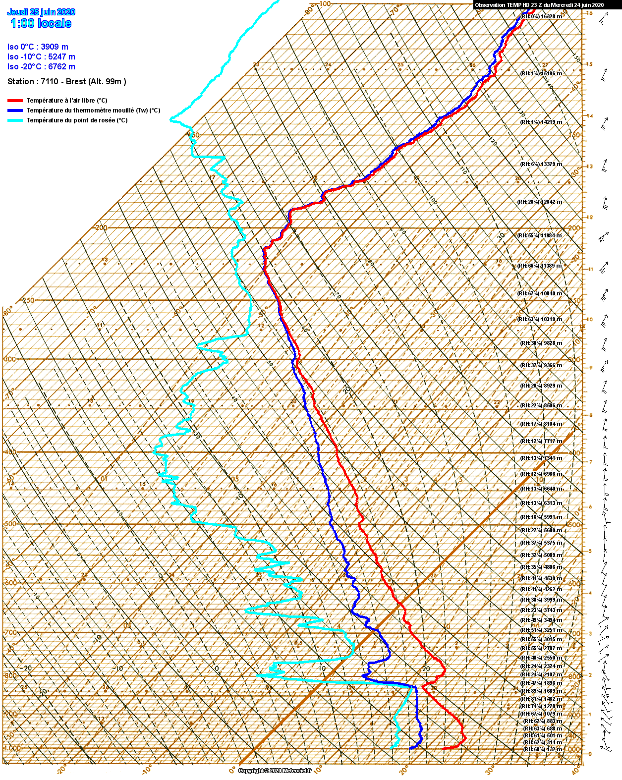
    Midnight radiosonde from Brest, NW France, shows a very strong cap above an elevated mixed layer. Plenty of CAPE there if it can be overcome, but a surface temperature of around 28 degrees would be needed to have a go at it. Most unstable layers are around 950 and 825 hPa.

    7110_0_2006242306.png


  • Registered Users, Registered Users 2 Posts: 25,131 ✭✭✭✭Kermit.de.frog


    Storm 10 wrote: »
    Hate to throw a spanner in the works

    Met Eireann:

    The risk of
    thunderstorms is greatest in Ulster and Connacht


  • Registered Users, Registered Users 2 Posts: 574 ✭✭✭Wine Goddess


    Midnight radiosonde from Brest, NW France, shows a very strong cap above an elevated mixed layer. Plenty of CAPE there if it can be overcome, but a surface temperature of around 28 degrees would be needed to have a go at it. Most unstable layers are around 950 and 825 hPa.

    Met Eireann forecasting 29c in Firhouse by 5pm. We could definitely make it!


  • Registered Users, Registered Users 2 Posts: 18,488 ✭✭✭✭JCX BXC


    Met Eireann forecasting 29c in Firhouse by 5pm. We could definitely make it!

    Is that their hourly forecast for your location.

    Always overestimates high temperatures, knock 2-3°c minimum off every time it forecasts temperatures like that.


  • Registered Users, Registered Users 2 Posts: 2,030 ✭✭✭Slashermcguirk


    Why would met eireann get it so wrong when Ireland weather is their only focus
    JCX BXC wrote: »
    Is that their hourly forecast for your location.

    Always overestimates high temperatures, knock 2-3°c minimum off every time it forecasts temperatures like that.


  • Registered Users, Registered Users 2 Posts: 332 ✭✭Paso Fino


    Very hot and muggy when I was out at 8am - house is roasting, even with every window open - I need a fan!!


  • Advertisement
  • Registered Users, Registered Users 2 Posts: 8,913 ✭✭✭Danno


    Midnight radiosonde from Brest, NW France, shows a very strong cap above an elevated mixed layer. Plenty of CAPE there if it can be overcome, but a surface temperature of around 28 degrees would be needed to have a go at it. Most unstable layers are around 950 and 825 hPa.


    Forecasts are for 28c in places today.

    At 10am (9UTC) it was at 20.2c in Durrow with a wet bulb of 17.4c.

    Some "popcorn" cloud about - similar to what was over Dublin last evening.

    Also GL - you'll be glad to know I put out a spare MAX thermometer into direct sunlight this morning - just to see! ;)


Advertisement