Advertisement
If you have a new account but are having problems posting or verifying your account, please email us on hello@boards.ie for help. Thanks :)
Hello all! Please ensure that you are posting a new thread or question in the appropriate forum. The Feedback forum is overwhelmed with questions that are having to be moved elsewhere. If you need help to verify your account contact hello@boards.ie
Hi there,
There is an issue with role permissions that is being worked on at the moment.
If you are having trouble with access or permissions on regional forums please post here to get access: https://www.boards.ie/discussion/2058365403/you-do-not-have-permission-for-that#latest

Florence

12346»

Comments

  • Moderators, Society & Culture Moderators Posts: 1,733 Mod ✭✭✭✭star gazer


    The hourly NHC update. Pressure rising as expected with landfall and some storm rainfall totals so far.
    501
    WTNT61 KNHC 141559
    TCUAT1

    Hurricane Florence Tropical Cyclone Update
    NWS National Hurricane Center Miami FL AL062018
    1200 PM EDT Fri Sep 14 2018

    ...FLORENCE WOBBLING SLOWLY WESTWARD OVER EXTREME SOUTHERN NORTH
    CAROLINA...

    NOAA Doppler weather radar data and surface observations indicate
    that the center of Hurricane Florence has turned back toward west.
    An erratic motion between westward and west-southwestward is likely
    today.

    During the past hour, a station operated by Weatherflow at Federal
    Point, North Carolina, reported a sustained wind of 56 mph (90 km/h)
    and a gust to 72 mph (116 km/h), a sustained wind of 53 mph (85
    km/h) and a gust to 72 mph (116 km/h) was observed at Mercer Pier in
    Wrightsville Beach, and a sustained wind of 51 mph (82 km/h) and a
    gust to 75 mph (121 km/h) was measured at the Wilmington offshore
    buoy. In addition, an Amateur Radio operator in Oak Island near
    Cape Fear, North Carolina, recently reported a sustained wind of 68
    mph (109 km/h) and a gust to 87 mph (140 km/h).

    Some Hurricane Florence heavy rainfall reports received thus far --

    18.53 inches Oriental, NC
    14.07 inches Surf City, NC
    13.81 inches WFO Morehead City, NC
    13.07 inches Jacksonville, NC


    SUMMARY OF 1200 PM EDT...1600 UTC...INFORMATION
    LOCATION...34.0N 78.2W
    ABOUT 25 MI...45 KM WSW OF WILMINGTON NORTH CAROLINA
    ABOUT 45 MI...75 KM ENE OF MYRTLE BEACH SOUTH CAROLINA
    MAXIMUM SUSTAINED WINDS...80 MPH...130 KM/H
    PRESENT MOVEMENT...SW OR 270 DEGREES AT 6 MPH...9 KM/H
    MINIMUM CENTRAL PRESSURE...964 MB...28.47 INCHES

    $$
    Forecaster Stewart


  • Registered Users, Registered Users 2 Posts: 8,219 ✭✭✭Gaoth Laidir


    star gazer wrote: »
    Florence is moving slowly along the coast, just inland.


    It's a good question. They could add something like large, medium and small storm (wind field) and have a set size for each (and also add the total kinetic energy estimate?). Or an estimate of total land rainfall from it? The wind speed is too important to be left out but adding something onto the wind scale could be useful with good education messages about meaning. Fortunately with Florence much of the preparation was done in anticipation of a higher category storm that made most sit up and respect warnings. The late messages of downgrading Categories may have led a few to complacency but hopefully not too many who weren't going to take the risk anyway. The eyewall was hard to anticipate in the days before landfall, worth studying for future reference. The forecasting

    It's important to acknowledge the people who forecast and research the science to better understand what is going on currently and what will happen. Mostly it's a great convenience to know what weather is forecast but it saves lives and livelihoods too.

    I think the current Saffir Simpson scales are good enough. The lower scales 1 and 2 are narrow enough to give a good indication of windspeed. Major scales 3-5 do get broader but at that stage it's getting serious enough that people need to get out and that's it. Destructive potential v windspeed is not a linear scale, but it really doesn't matter. For Cat 3 and above get out and stay out.

    The NHC had a major bust with their intensity forecasts of Florence over the past week, but particularly the past 3 days. For some reason they were going a bit tabloid with their figures and language. Yes, it's the peak of the season, but the data were always stacked against the major landfall they continuously predicted. At less than 24 hours out they were 40 knots out with their peak intensity for yesterday (135 kts versus actual 95 kts). The highest Florence got to was 120 kts, and even at that this figure was very questionable the past few days. They had been forecasting 135 kts and 140 kts for days, but it was never going to happen over ocean heat content too low that far north and in such a swathe of dry air over the whole ocean. This is the 2nd year I've noticed this with US-landfalling hurricanes. Strange.


  • Moderators, Society & Culture Moderators Posts: 1,733 Mod ✭✭✭✭star gazer


    I think the current Saffir Simpson scales are good enough. The lower scales 1 and 2 are narrow enough to give a good indication of windspeed. Major scales 3-5 do get broader but at that stage it's getting serious enough that people need to get out and that's it. Destructive potential v windspeed is not a linear scale, but it really doesn't matter. For Cat 3 and above get out and stay out.

    The NHC had a major bust with their intensity forecasts of Florence over the past week, but particularly the past 3 days. For some reason they were going a bit tabloid with their figures and language. Yes, it's the peak of the season, but the data were always stacked against the major landfall they continuously predicted. At less than 24 hours out they were 40 knots out with their peak intensity for yesterday (135 kts versus actual 95 kts). The highest Florence got to was 120 kts, and even at that this figure was very questionable the past few days. They had been forecasting 135 kts and 140 kts for days, but it was never going to happen over ocean heat content too low that far north and in such a swathe of dry air over the whole ocean. This is the 2nd year I've noticed this with US-landfalling hurricanes. Strange.
    Interestingly the NHC and others got the intensity wrong the other way around out in the Atlantic as expected dry air and cooler ocean surface temps didn't stop it going to Category 4 the first time. The point i'm thinking of is when a Hurricane is "only" Cat 1 or 2 but has likely very large impacts expected and how does it get translated to people that while the winds may not be catastrophic some of the storm surge and rainfall accumulations could be? I don't think the Saffir Simpson Hurricane wind scale should be changed just add to it, like a Category 2 Hurricane with large impacts but help people understand the danger.


  • Moderators, Society & Culture Moderators Posts: 1,733 Mod ✭✭✭✭star gazer


    Two fatalities reported on CNN as a tree fell into a house. Dozens trapped by storm surge and flood waters. It's a seriously destructive Hurricane.

    abc news on Florence
    https://twitter.com/ABC/status/1040647532366508035

    There's a wave by the window.
    https://twitter.com/DavidWMTW/status/1040546042364743680


  • Registered Users, Registered Users 2 Posts: 8,219 ✭✭✭Gaoth Laidir


    star gazer wrote: »
    Interestingly the NHC and others got the intensity wrong the other way around out in the Atlantic as expected dry air and cooler ocean surface temps didn't stop it going to Category 4 the first time. The point i'm thinking of is when a Hurricane is "only" Cat 1 or 2 but has likely very large impacts expected and how does it get translated to people that while the winds may not be catastrophic some of the storm surge and rainfall accumulations could be? I don't think the Saffir Simpson Hurricane wind scale should be changed just add to it, like a Category 2 Hurricane with large impacts but help people understand the danger.

    To be fair the NHC do give great detail on local effects and warnings in the Public and Forecast Advisories and the Discussions, so personally I wouldn't have a problem there. It's just that sometimes their interpretations seem to tilt in favour of maintaining high intensities. They tend to go above the aircraft recon data for US-landfalling systems, quoting possible undersampling of max winds, yet with other storms they take the recon values at face value (e.g. Isaac yesterday). Not only recon figures, either.

    Anyway, at least they're not in Ireland, facing this monster...:rolleyes:

    461304.PNG


  • Registered Users, Registered Users 2 Posts: 9,988 ✭✭✭spookwoman


  • Registered Users, Registered Users 2 Posts: 32,634 ✭✭✭✭Graces7


  • Registered Users, Registered Users 2 Posts: 9,241 ✭✭✭sdanseo


    Graces7 wrote: »

    RTÉ top-notch reporting as usual.
    Florence had been a Category 3 hurricane on the five-step Saffir-Simpson scale with 1930km/h winds as of Thursday, but dropped to a Category 1 hurricane before coming ashore.


  • Registered Users, Registered Users 2 Posts: 22,676 ✭✭✭✭Akrasia


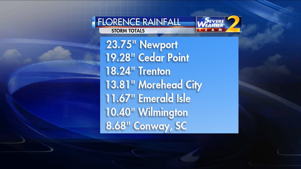
    Pretty heavy rainfall totals in some areas already with the potential for 10-20 inches more before the event is over

    DnIiUSvX0AYTr2d.jpg


  • Registered Users Posts: 10,673 ✭✭✭✭MJohnston


    For context, the average annual rainfall for Dublin is 28.8 inches.


  • Advertisement
  • Registered Users, Registered Users 2 Posts: 20,467 ✭✭✭✭Rikand


    MJohnston wrote: »
    For context, the average annual rainfall for Dublin is 28.8 inches.

    Ah sure the wesht gets 28 inches every day and doesnt even make a dent


  • Registered Users, Registered Users 2 Posts: 9,420 ✭✭✭splinter65


    Rikand wrote: »
    Ah sure the wesht gets 28 inches every day and doesnt even make a dent

    Even in the heatwave shure it rained non stop....


  • Registered Users, Registered Users 2 Posts: 32,634 ✭✭✭✭Graces7


    sdanseo wrote: »
    RTÉ top-notch reporting as usual.

    You must be a professional proofreader!


  • Registered Users Posts: 4,694 ✭✭✭SleetAndSnow


    sdanseo wrote: »
    RTÉ top-notch reporting as usual.

    God somebody must have changed the scales of what makes a hurricane! if that is CAT 3 id dread to see CAT 5!


  • Registered Users, Registered Users 2 Posts: 13,679 ✭✭✭✭sryanbruen


  • Registered Users, Registered Users 2 Posts: 22,676 ✭✭✭✭Akrasia


    A scientific analysis of hurricane Florence has already been released with preliminary results attributing 50% of the rainfall to climate change. And saying that Florence remained a higher category storm for longer and grew 80 kilometers larger than it would have been if the global warming signal was removed

    https://cpb-us-e1.wpmucdn.com/you.stonybrook.edu/dist/4/945/files/2018/09/climate_change_Florence_0911201800Z_final-262u19i.pdf

    The study is based on the CAM model


  • Registered Users Posts: 10,673 ✭✭✭✭MJohnston


    Rikand wrote: »
    Ah sure the wesht gets 28 inches every day and doesnt even make a dent


    I don't want to hear about Wesht's sex life, whoever they are


  • Registered Users, Registered Users 2 Posts: 9,241 ✭✭✭sdanseo


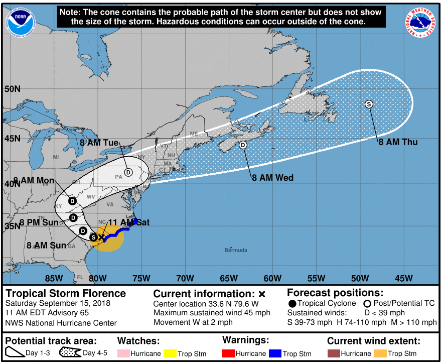
    We might not have seen the last of Florence yet from an Irish perspective. NHC now expecting her to reintensify to a Tropical Storm east of Newfoundland and hurtle in our direction towards next weekend.

    At that stage, if it verified, it will have been a named system for more than 3 weeks.

    46b8277903ab35f2eeb06d67f158148a.png


  • Moderators, Recreation & Hobbies Moderators Posts: 11,801 Mod ✭✭✭✭igCorcaigh


    MJohnston wrote: »
    I don't want to hear about Wesht's sex life, whoever they are

    LOL!


  • Advertisement
  • Registered Users, Registered Users 2 Posts: 8,219 ✭✭✭Gaoth Laidir


    Akrasia wrote: »
    A scientific analysis of hurricane Florence has already been released with preliminary results attributing 50% of the rainfall to climate change. And saying that Florence remained a higher category storm for longer and grew 80 kilometers larger than it would have been if the global warming signal was removed

    https://cpb-us-e1.wpmucdn.com/you.stonybrook.edu/dist/4/945/files/2018/09/climate_change_Florence_0911201800Z_final-262u19i.pdf

    The study is based on the CAM model

    So they compared one fully-coupled model to the uncoupled GFS, which has been generating comical forecasts on Florence all week. It's not surprising to find such differences between these two models as the GFS has been that different to all the other models too! Is this paper real science or a wind-up?


  • Registered Users, Registered Users 2 Posts: 6,467 ✭✭✭jimmynokia


    Media already telling us its going to kill us all.. Usual BS.


  • Registered Users, Registered Users 2 Posts: 22,676 ✭✭✭✭Akrasia


    So they compared one fully-coupled model to the uncoupled GFS, which has been generating comical forecasts on Florence all week. It's not surprising to find such differences between these two models as the GFS has been that different to all the other models too! Is this paper real science or a wind-up?

    Real science.


  • Moderators, Society & Culture Moderators Posts: 1,733 Mod ✭✭✭✭star gazer


    To be fair the NHC do give great detail on local effects and warnings in the Public and Forecast Advisories and the Discussions, so personally I wouldn't have a problem there. It's just that sometimes their interpretations seem to tilt in favour of maintaining high intensities. They tend to go above the aircraft recon data for US-landfalling systems, quoting possible undersampling of max winds, yet with other storms they take the recon values at face value (e.g. Isaac yesterday). Not only recon figures, either.
    <snip>
    I think the current Saffir Simpson scales are good enough. The lower scales 1 and 2 are narrow enough to give a good indication of windspeed. Major scales 3-5 do get broader but at that stage it's getting serious enough that people need to get out and that's it. Destructive potential v windspeed is not a linear scale, but it really doesn't matter. For Cat 3 and above get out and stay out.

    This is the crux of it, if you have it at a lower Category 1 or 2, it's more difficult to have people "get out and stay out" which is where Florence ended up coming into landfall and yet the flooding is so bad as to warrant the evacuations. That then could be helped by distilling what the NHC has in advisories (and everyone else) into some measure of the windfield, rain and surge potential. So you have a wind scale plus.


  • Registered Users, Registered Users 2 Posts: 2,033 ✭✭✭irishrover99


    sdanseo wrote: »
    We might not have seen the last of Florence yet from an Irish perspective. NHC now expecting her to reintensify to a Tropical Storm east of Newfoundland and hurtle in our direction towards next weekend.

    At that stage, if it verified, it will have been a named system for more than 3 weeks.

    46b8277903ab35f2eeb06d67f158148a.png

    If things keeps going at this rate, we’ll have a new influx of tourists.

    Storm chasers 😀.


  • Moderators, Society & Culture Moderators Posts: 1,733 Mod ✭✭✭✭star gazer


    It's heading slowly West, then North West through South Carolina for the next day or so but a lot of the heavy rains are still being pulled in over North Carolina.
    600mm for Newport, North Carolina so far. Around the 600mm is the storm rainfall total record for the State.

    Rainfall totals
    https://twitter.com/breakingweather/status/1040991145994727424
    https://twitter.com/wxjerdman/status/1040998275892031488

    Rainband
    https://twitter.com/StuOstro/status/1041005078440751104

    There goes the neighbourhood
    https://twitter.com/ABC/status/1041006197200052226


  • Advertisement
  • Registered Users Posts: 2,029 ✭✭✭Artane2002


    sdanseo wrote: »
    We might not have seen the last of Florence yet from an Irish perspective. NHC now expecting her to reintensify to a Tropical Storm east of Newfoundland and hurtle in our direction towards next weekend.

    At that stage, if it verified, it will have been a named system for more than 3 weeks.

    Or ex-Florence but with tropical storm force winds ;)


  • Registered Users Posts: 10,673 ✭✭✭✭MJohnston


    sdanseo wrote: »
    We might not have seen the last of Florence yet from an Irish perspective. NHC now expecting her to reintensify to a Tropical Storm east of Newfoundland and hurtle in our direction towards next weekend.

    At that stage, if it verified, it will have been a named system for more than 3 weeks.


    I don't know if it's recent or not, but there's a Storm Track section on Meteologix now, based on the ECM, and it shows a bit further out on the tracks than NOAA:


    https://meteologix.com/ie/cyclone-tracks/euro/grid-europe-africa/2018091512-240-florence.html


    Doesn't look like it'll bother us much:


    zCl7AW9.png


  • Registered Users, Registered Users 2 Posts: 8,219 ✭✭✭Gaoth Laidir


    The last advisory on Florence - now a Tropical Depression - has just been issued, It's picking up forward speed a bit.

    https://www.nhc.noaa.gov/text/refresh/MIATCDAT1+shtml/160848.shtml


  • Registered Users, Registered Users 2 Posts: 6,467 ✭✭✭jimmynokia


  • Registered Users Posts: 643 ✭✭✭REBELSAFC


    How apt that Emerald Isle was one of the wettest areas in North Carolina!!:D:D

    https://twitter.com/breakingweather/status/1040991145994727424


  • Advertisement
  • Registered Users, Registered Users 2 Posts: 13,679 ✭✭✭✭sryanbruen


  • Registered Users, Registered Users 2 Posts: 8,219 ✭✭✭Gaoth Laidir


    Florence Storm Totals up to today

    https://www.wpc.ncep.noaa.gov/discussions/nfdscc4.html
    ...Selected preliminary Storm Total Rainfall in inches from 200 PM
    EDT Thu Sep 13 through 1000 AM EDT Mon Sep 17...

    ...NORTH CAROLINA...
    ELIZABETHTOWN 6.2 NW 35.93 LISTED AS SUSPECT
    SWANSBORO 1.4 N 33.89
    GURGANUS .5 N 30.38
    HOFMANN FOREST RAWS 29.62
    HAMPSTEAD 4.1 WNW 29.52
    SUNNY POINT RAWS 27.44
    NATURE CONSERVANCY RAWS 27.40
    OAK ISLAND .9 ENE 26.98
    WILMINGTON 7.3 NE 26.58
    WHITEVILLE 6.1 NW 25.91
    NEWPORT/MOREHEAD CITY NWS WFO 25.20
    MT. OLIVE 0.4 NW 25.04
    NEWPORT .2 SW 23.86
    TURNBULL CREEK RAWS 23.67
    EMERALD ISLE 0.2 ENE 23.49
    MAYSVILLE 3.4 SSW 23.07
    WILMINGTON INTL AP (KILM) 23.02
    LUMBERTON 2.3 NE 22.76
    YAUPON BEACH 22.07
    SUPPLY 4 NNW 21.92
    CEDAR POINT 0.9 WSW 21.73
    CROATAN RAWS 21.70
    BOLIVIA 7.8 SW 21.59
    MOREHEAD CITY .6 NW 21.20
    BACK ISLAND RAWS 20.87
    SANDY RUN RAWS 19.92
    FAYETTEVILLE (KFAY) 15.27
    PIEDMONT TRIAD INTL AP (KGSO) 6.99
    RALEIGH-DURHAM INTL AP (KRDU) 6.98
    CHARLOTTE/DOUGLAS INTL AP (KCLT) 6.13

    ...SOUTH CAROLINA...
    LORIS 2.9 WSW 23.63
    LORIS 1.4 ENE 23.18
    CHERAW WATER PLANT 22.58
    CAROLINA SAND HILLS RAWS (6E JEFFS 21.18
    CHESTERFIELD (MAIN ST) 19.94
    MARION 3 E RAWS 19.56
    DILLON 3.8 NW 18.38
    PAWLEYS ISLAND 2.6 N 15.75
    BENNETTSVILLE 1.2 SE 15.68
    MYRTLE BEACH 8.4 NNW 15.41
    HORRY RAWS 13.52
    MCBEE (USGS) 12.77
    GRAND STRAND AP (KCRE) 11.47
    HARTSVILLE 1.7 NW 11.39
    PEE DEE RIVER 11.29
    PAGELAND 3 SE 10.23
    CONWAY HADS 10.10
    FLORENCE AP (KFLO) 7.62
    ROCK HILL 2 W 7.48

    ...VIRGINIA...
    MEADOWS OF DAN 4.5 SW 10.56
    WILLIS 2.7 SE 9.86
    COPPER HILL 6.2 S 9.54
    CALLAWAY 4 WSW 8.84
    STUART 8.65
    CHECK 8.33
    FERRUM 6.60
    HORSE PASTURE 2 E 6.05
    WOOLWINE 5.86
    LAUREL FORK 5.65
    ROCKY MOUNT 4.3 NNW 5.65
    BENT MOUNTAIN 1 NNE 5.64
    SHAWSVILLE 4 E 5.60
    GALAX 5.25
    POAGES MILL 2 W 5.24
    DANVILLE REGL AP 5.00

    ...Selected preliminary Peak Wind gusts in miles per hour earlier
    in the event...

    ...GEORGIA...
    TYBEE ISLAND 1SSW 42
    FORT PULASKI 41
    AUGUSTA BUSH FIELD 39
    SAVANNAH AIRPORT 37
    STATESBORO 36

    ...NORTH CAROLINA...
    BUOY 30 SE NEW RIVER INLET 112
    FORT MACON 105
    WILMINGTON INT'L ARPT (KILM) 105
    CAPE LOOKOUT 97
    CEDAR ISLAND 1 N 89
    CHERRY POINT ASOS 87
    JACKSONVILLE ASOS 86
    FRISCO WOODS 80
    OCRACOKE 80
    HARKERS ISLAND 77
    DIAMOND SHOALS BUOY 76
    NORTH RIVER 75
    AVON 74
    BUXTON 73
    SNEADS FERRY 1 SSE 72
    NEW RIVER MCAS 70
    LUMBERTON MUNI 69
    FAYETTEVILLE REGIONAL AIRPORT 66
    FORT BRAGG/SIMMO 66
    ROMINGER 2 SSW 61
    SILVERSTONE 1 SE 58
    RALEIGH-DURHAM INTL AIRPORT 47
    CHARLOTTE/DOUGLAS AIRPORT 34

    ...SOUTH CAROLINA...
    CHARLESTON 4 ESE 56
    FT. SUMTER RANGE FRONT LIGHT 55
    EDISTO BUOY 41004 54
    SHAW AFB 54
    CHARLESTON INTL AIRPORT 53
    CAPERS NEARSHORE BUOY 41029 51
    FLORENCE REGIONAL AIRPORT 50
    MYRTLE BEACH AFB 48
    DEWEES ISLAND 5 ESE 47
    MCENTIRE ANG 47
    PINOPOLIS 47
    SUMTER MUNICIPAL AIRPORT 47
    CAMDEN-WOODWARD FIELD 45
    SULLIVANS ISLAND 1 ENE 45
    WILD DUNES 2 WSW 45
    FOLLY BEACH 44
    BATTERY POINT 1 NNW 43
    BEAUFORT 43
    ORANGEBURG MUNICIPAL AIRPORT 40

    ...VIRGINIA...
    MOUNTAIN LAKE 48
    NORFOLK NAVAL AIR STATION 38
    PENHOOK 3 NE 38
    ROANOKE REGL AP 38
    BURKES GARDEN 37
    LANGLEY AFB 37
    NORFOLK AIRPORT 37
    VIRGINIA BEACH OCEANA 37
    MEADOWS OF DAN 1 W 35
    WALLOPS ISLAND 35
    DANVILLE REGL AP 33
    NEWPORT NEWS AIRPORT 33


  • Registered Users, Registered Users 2 Posts: 9,241 ✭✭✭sdanseo


    Florence predicted to strengthen again in a couple of days:
    (30W is approx. mid-Atlantic)
    NOAA wrote:
    https://www.wpc.ncep.noaa.gov/tropical/tropical_advisories.php?storm=FLORENCE
    72H 20/1200Z 41.0N 53.9W 35 KT 40 MPH...POST-TROP/EXTRATROP
    96H 21/1200Z 40.7N 43.2W 40 KT 45 MPH...POST-TROP/EXTRATROP
    120H 22/1200Z 42.3N 34.5W 45 KT 50 MPH...POST-TROP/EXTRATROP


  • Registered Users, Registered Users 2 Posts: 15,951 ✭✭✭✭Villain


    This is why looking at wind speeds only is never a good idea!

    https://twitter.com/carlowweather/status/1041791010353934337?s=21


  • Moderators, Recreation & Hobbies Moderators Posts: 11,801 Mod ✭✭✭✭igCorcaigh


    Sep 19, 2018

    Tropical Rainstorm Florence is moving east over the open waters of the northwestern Atlantic and is now positioned southeast of Nova Scotia. The storm will remain classified as a non-tropical storm system as it races eastward at 25-30 mph. The storm system will merge with a southward-moving cold front and the whole system will move eastward across the North Atlantic for the next few days. Eventually, the storm will intensify and become a very powerful wind and rainstorm as it approaches Ireland and the United Kingdom. What once was a powerful hurricane will bring strong, perhaps damaging winds and heavy rainfall to parts of Ireland and Northern Ireland and mostly the northern United Kingdom this weekend, mostly during Sunday.

    https://m.accuweather.com/en/hurricane/atlantic


Advertisement