Advertisement
If you have a new account but are having problems posting or verifying your account, please email us on hello@boards.ie for help. Thanks :)
Hello all! Please ensure that you are posting a new thread or question in the appropriate forum. The Feedback forum is overwhelmed with questions that are having to be moved elsewhere. If you need help to verify your account contact hello@boards.ie

Extending the Luas beyond Red, Green and BXD - see post #14

Options
13

Comments

  • Registered Users Posts: 1,512 ✭✭✭strassenwo!f


    You claim there is no demand for a frequency below 3 minutes. The luas frequency is between 3-5 minutes and is rammed at peak the new green line trams will be 54 meters long but will only add space for an additional 60 people it's basically maxed out

    If you look at many European cities which rely largely on trams, and a city like Dresden would be a nice example, you will see many tram lines going every which way. For people living or working between these lines the lines are effectively competing with each other to hoover up custom from their catchment area, which overlaps with the realistic catchment area of one or more other lines. This is good for the consumer.

    In Dublin's southside, there is a dearth of tram lines (relative to somewhere like Dresden, I stress, not to the rest of Dublin), so the catchment area for each tram or rail line is huge, and there's effectively no competition between them. This is not good for the consumer: for example, someone living near to the N11 in Stillorgan, say, isn't particularly close to the DART and also isn't particularly close to the LUAS. Such a person, and there are many, has a fairly significant trip to get to the DART or the LUAS even to start their journey on rail-based transport.

    The proposal to improve the service on the LUAS green line by extending the metro north via a tunnel between St. Stephen's Green and Ranelagh fails to address this issue. If a tunnel needs to be built, it would be much better to build a tunnel between St. Stephen's Green and the N11 to create an entirely new corridor between the DART and the LUAS, which would also relieve the pressure on both by hoovering up many people who are currently caught between those two stools and who should not, by the standards of a developed city like Dresden, be part of the catchment area of either.

    The same goes for the area between the red and green lines, though the gap is much larger and there is an even larger amount of people who are not close to either DART or LUAS. Someone in Terenure, for example, is very remote from either of the LUAS lines and light years away from the DART.

    I believe that it would make more sense to build such a tunnel from St. Stephen's Green toward the south-west of the city (eventually leading to routes serving Rathmines, Harold's Cross, Terenure, Walkinstown, etc.), because there is no obvious overground LUAS route between those areas and the city centre, while the N11 presents several possibilities.

    The idea with such a tunnel would be that it would introduce competition along two or more new routes, between the southside red and green LUAS lines, to improve the consumer experience for those on the current routes and those on the potential new routes, by relieving pressure on both red and green LUAS lines by reducing their effective catchment areas.


  • Registered Users Posts: 1,512 ✭✭✭strassenwo!f


    I fully understand that most of the people in the NTA have little or no experience of living/working for a significant length of time in a city outside of Ireland. I think it is very important that they have an opportunity to see the views of those who have, on issues like the fantastic public transport we've seen, and all very kindly enabled by the good folk here at boards.ie.


  • Registered Users Posts: 62 ✭✭Rojomur


    Going off in a slightly different direction and d something that wont happen for years but ive seen the latest draft proposal by fingal county council online. They are looking to secure a track of land from lissenhall to donabate for future rail line.... It looks to be connecting the future metro north beyond the airport to Dart in Donabate. Could be very benefitial to all the bew houses proposed for lissenhall and north of swords... I hope the link below works.

    https://consult.fingal.ie/en/consultation/proposed-material-alterations-draft-fingal-development-plan-2017-2023/chapter/sheet-7-–


  • Registered Users Posts: 8,229 ✭✭✭LeinsterDub


    Rojomur wrote: »
    Going off in a slightly different direction and d something that wont happen for years but ive seen the latest draft proposal by fingal county council online. They are looking to secure a track of land from lissenhall to donabate for future rail line.... It looks to be connecting the future metro north beyond the airport to Dart in Donabate. Could be very benefitial to all the bew houses proposed for lissenhall and north of swords... I hope the link below works.

    https://consult.fingal.ie/en/consultation/proposed-material-alterations-draft-fingal-development-plan-2017-2023/chapter/sheet-7-–;

    Interesting. Link doesn't work BTW


  • Registered Users Posts: 62 ✭✭Rojomur


    Its odd leinsterDub....my link doesnt work but when i click on the link in your quote box it does🀔🀔. Anyway Its down at SH7.7 and the map shows the transport corridor if you want to look. It doesnt specify what kind of transport but its coming from the metro north lissenhall area.


  • Advertisement
  • Registered Users Posts: 665 ✭✭✭ricimaki


    Here are links to the PDF, and sheet 7 (Donabate) and 8 (Swords) jpg images for reference. Sheet 8 shows the end of Metro north, but 7 shows no mention of Metro or rail transport:
    PDF
    Sheet 7
    Sheet 8


  • Registered Users Posts: 62 ✭✭Rojomur


    The plan im talking about is titled Book of sheets 1-16 and its on pg 38 of the plan. Its accessed from the fingal coco site and its under Stage 3 Material Proposed Alterations from the Develipment plan home tab. Sorry i cant create link. As i said it doesnt specify rail connection...just says future transport connection which from the map comes directly off the future metro north track between estuary and lisenhall. Hopefully somebody can figure out how to create a link to this particular document. The reason im mentioning it here is that there seems to be quiet a few people on other boards discussion sites whom reckon the future metro north will not be DART heavy rail, but maybe a luas type connection to save money.


  • Registered Users Posts: 1,067 ✭✭✭xper


    Idbatterim wrote: »
    new cherrywood town of 30,000 to be served by four existing luas stop. Surely it now makes sense for the council, to have a development plan in place for the extension to bray, so that similar schemes can be routed along its length?

    http://www.independent.ie/business/personal-finance/property-mortgages/biggest-ever-development-will-house-30000-35438925.html
    Well yes, it would so they do. That's why the B2 extension proposal to Bray/Fasseroe exists in the first place and follows the proposed route(s) it does through/to greenfield sites. There are major developments earmarked for Woodbrook, Fasseroe and the former golf club lands in Bray, all served by the proposed Luas B2 route. Planning permission has been applied for for the first element of the Fasseroe new town and a school and access roads are already under construction on the site in Bray. Of course, unlike Cherrywood, it looks like the Luas will arrive long after the building gets underway, if ever.

    We generally have had no trouble in the last thirty years or so with getting qualified, competent planning professionals to come up with joined-up, long term plans for urban development. The problem is the political meddling in implementing these plans.


  • Closed Accounts Posts: 2,379 ✭✭✭newacc2015


    xper wrote: »
    Well yes, it would so they do. That's why the B2 extension proposal to Bray/Fasseroe exists in the first place and follows the proposed route(s) it does through/to greenfield sites. There are major developments earmarked for Woodbrook, Fasseroe and the former golf club lands in Bray, all served by the proposed Luas B2 route. Planning permission has been applied for for the first element of the Fasseroe new town and a school and access roads are already under construction on the site in Bray. Of course, unlike Cherrywood, it looks like the Luas will arrive long after the building gets underway, if ever.

    If we had a proper LPT system, the councils could build these with the justification of they will collect x amount more of LPT due to the new lines. But there isn't even LPT on properties built post 2013!

    Brooklyn is getting new tramlines, as the city knows the hike in property taxes from the increased property value will cover a lot of the construction cost. That should be the same here.

    Do you know if there is at least development levies for the Luas lines on these new developments?


  • Registered Users Posts: 920 ✭✭✭Last Stop


    Would love to see a line continuing from Metro North at Stephens Green - Lesson st - Surfacing after Donnybrook, travelling along the N11 and tying back into the green line at Sandyford.
    Would take pressure off Cherrywood and also serve UCD and Stillorgan.
    At the minute the N11 is roughly equidistant between the DART snd LUAS yet both are a bit too far to use everyday.


  • Advertisement
  • Registered Users Posts: 10,550 ✭✭✭✭MJohnston


    Last Stop wrote: »
    Would love to see a line continuing from Metro North at Stephens Green - Lesson st - Surfacing after Donnybrook, travelling along the N11 and tying back into the green line at Sandyford.
    Would take pressure off Cherrywood and also serve UCD and Stillorgan.
    At the minute the N11 is roughly equidistant between the DART snd LUAS yet both are a bit too far to use everyday.

    Would say that it'd be a decent enough route (hence the QBC along the N11 at the minute), but way down the priority list given that, as you mention, the DART and Green Line surround this area. Dublin priority has to be Metro North, DU, then R114 and N2 corridors imo. After that, we will have the major "spokes" of a network in place and can start working on orbital connections and more granular "spokes" in between them.


  • Registered Users Posts: 3,670 ✭✭✭quadrifoglio verde


    MJohnston wrote: »
    Would say that it'd be a decent enough route (hence the QBC along the N11 at the minute), but way down the priority list given that, as you mention, the DART and Green Line surround this area. Dublin priority has to be Metro North, DU, then R114 and N2 corridors imo. After that, we will have the major "spokes" of a network in place and can start working on orbital connections and more granular "spokes" in between them.

    Metro north should continue south, stopping at Camden St, Harold's cross, terenure and rathfarnham. That whole area is dreadfully serviced by public transport and the bus situation is a joke. I've walked into town a few times faster than the 16 at rush hour in the morning.


  • Registered Users Posts: 3,612 ✭✭✭Dardania


    MJohnston wrote: »
    Would say that it'd be a decent enough route (hence the QBC along the N11 at the minute), but way down the priority list given that, as you mention, the DART and Green Line surround this area. Dublin priority has to be Metro North, DU, then R114 and N2 corridors imo. After that, we will have the major "spokes" of a network in place and can start working on orbital connections and more granular "spokes" in between them.

    Metro north should continue south, stopping at Camden St, Harold's cross, terenure and rathfarnham. That whole area is dreadfully serviced by public transport and the bus situation is a joke. I've walked into town a few times faster than the 16 at rush hour in the morning.
    That's a great idea. I alway presumed MN would just go north from Stephen's Green. But for the surprise factor in getting public / political support...could work


  • Registered Users Posts: 270 ✭✭ncounties


    I've always thought that if Metro North were to be extended South, it shouldn't follow the Green Line... I would agree with all stops bar Harold's Cross, preferring the alignment to be Rathmines, Terenure, Rathfarnham.


  • Registered Users Posts: 3,670 ✭✭✭quadrifoglio verde


    ncounties wrote: »
    I've always thought that if Metro North were to be extended South, it shouldn't follow the Green Line... I would agree with all stops bar Harold's Cross, preferring the alignment to be Rathmines, Terenure, Rathfarnham.

    Harold's cross brings in more people. Rathmines to beech wood is a 10 minute walk so is reasonably well served as it is by luas.
    If you have a stop in Harold's cross, you cover the west side of rathmines from the main street to Harold's cross as well as kimmage.


  • Registered Users Posts: 1,512 ✭✭✭strassenwo!f


    ncounties wrote: »
    I've always thought that if Metro North were to be extended South, it shouldn't follow the Green Line... I would agree with all stops bar Harold's Cross, preferring the alignment to be Rathmines, Terenure, Rathfarnham.

    I agree that it is too early too upgrade the green line while other parts of the city are in greater need of good public transport, so you are right that it should go to the south-west of the city, if anywhere on the southside.

    But it is probably a mistake to think of an alignment, through areas of Dublin which have higher density than many suburbs of, for example, Munich, which already enjoy a U-Bahn service there. In order to utilise the capacity of the St. Stephen's Green - Airport section effectively it would be best to provide two alignments - as we see in cities like Munich - in this area, through a combination of tunnel and surface (and perhaps elevated?) routes.

    I would, for example, favour St. Stephen's Green to an underground station near the Bleeding Horse, then to Rathmines - Rathgar - Terenure and beyond on one branch, and to Harold's Cross - Kimmage and Walkinston Cross (and maybe beyond) on another. Some bits of these branches might be surface or elevated.

    Walkinstown Cross must certainly have enormous potential as a public transport node in this context, what with its location in the south-west, the large number of buses already going through there from many directions, and its closeness to the red line. Something very imaginative could surely be done there.


  • Registered Users Posts: 4,047 ✭✭✭afatbollix


    Finally found a map with old railways on it.

    Never knew about the Lucan railway or the one to Blessington!

    http://www.railmaponline.com/UKIEMap.php


  • Registered Users Posts: 9,786 ✭✭✭wakka12


    The john rocque map 1888-1913 available on geohive is also good for seeing the old layout of the Dublin tram network, and if youre interested, a very detailed map of literally every building in old dublin! Sad we lost such extensive transport infrastrucutre :(


  • Registered Users Posts: 2,242 ✭✭✭MayoSalmon


    afatbollix wrote: »
    Finally found a map with old railways on it.

    Never knew about the Lucan railway or the one to Blessington!

    http://www.railmaponline.com/UKIEMap.php

    Hmm grandfather used to tell me there was a railway line out to Dingle many moons ago..cant see it on that map though?!


  • Registered Users Posts: 3,397 ✭✭✭JohnC.


    MayoSalmon wrote: »
    Hmm grandfather used to tell me there was a railway line out to Dingle many moons ago..cant see it on that map though?!

    I can. One of the first things which struck me.


  • Advertisement
  • Registered Users Posts: 4,047 ✭✭✭afatbollix


    MayoSalmon wrote: »
    Hmm grandfather used to tell me there was a railway line out to Dingle many moons ago..cant see it on that map though?!

    That would be perfect for a vintage tourism line.


  • Registered Users Posts: 14,831 ✭✭✭✭loyatemu


    afatbollix wrote: »
    That would be perfect for a vintage tourism line.

    they did relay a small section of it near Tralee as a tourist line, it failed a few years ago but I believe there is a group trying to get it running again: http://traleesteamrailway.webs.com/


  • Moderators, Category Moderators, Computer Games Moderators, Society & Culture Moderators Posts: 8,467 CMod ✭✭✭✭Sierra Oscar


    I hope we see the proposal to extend the Luas from Broombridge to Finglas progressed. I reckon that project should be prioritised. The wider Finglas area would benefit greatly and there's great opportunity for housing development in the area.
    MayoSalmon wrote: »
    Hmm grandfather used to tell me there was a railway line out to Dingle many moons ago..cant see it on that map though?!

    It definitely existed. Some of it has been restored as a tourist attraction.

    Tralee and Dingle Light Railway


  • Registered Users Posts: 9,786 ✭✭✭wakka12


    I hope we see the proposal to extend the Luas from Broombridge to Finglas progressed. I reckon that project should be prioritised. The wider Finglas area would benefit greatly and there's great opportunity for housing development in the area.


    It definitely existed. Some of it has been restored as a tourist attraction.

    Tralee and Dingle Light Railway

    Are there any concrete plans for that? Or any current plans for luas extension of either lines?


  • Moderators, Category Moderators, Computer Games Moderators, Society & Culture Moderators Posts: 8,467 CMod ✭✭✭✭Sierra Oscar


    wakka12 wrote: »
    Are there any concrete plans for that? Or any current plans for luas extension of either lines?

    It's contained in the NTA's Draft Transport Strategy for the Greater Dublin Area 2016 - 2035
    It is intended to extend Luas Cross City from its terminus at Broombridge to the north of Finglas. This will provide a high capacity radial service from this large suburb into the city centre. It is also intended to provide a strategic park and ride at the terminus of this line on the N2 national road close to the M50.

    These proposals will serve the significant levels of forecast travel demand from this corridor to the city centre and Grangegorman.

    It's important to note that the proposed Lucan & Poolbeg extensions are also proposed in the document. It reads like an aspirational document.


  • Registered Users Posts: 5,818 ✭✭✭donvito99


    A run from SSG down Leeson Street and the N11 would seem to be feasible. It has a high quality bus corridor, but the capacity of trams would seem to be perfect for that alignment. The Donnybrook bottleneck might be an issue. It could also be tied in rather easily with the depot at Sandyford.


  • Registered Users Posts: 7,554 ✭✭✭GerardKeating


    ncounties wrote: »
    I've always thought that if Metro North were to be extended South, it shouldn't follow the Green Line... I would agree with all stops bar Harold's Cross, preferring the alignment to be Rathmines, Terenure, Rathfarnham.

    The original plan for it to extend (as Metro South) to Tallaght, via Harolds Cross, Kimmage etc, part of "platform for change"

    431012.jpg

    .


  • Registered Users Posts: 9,233 ✭✭✭sdanseo


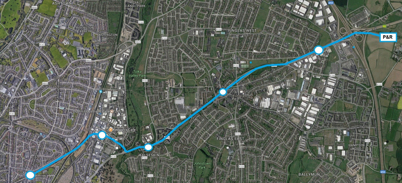
    P+R model should be expanded - we need to get these lines out to the M50 or beyond.

    Start where we have a base layer done already. From just before Broombridge there is space to expand as far as the M50 out the Finglas Road / N2 with minimal CPO. The main challenge is either a short tunnel bore under, or knocking, part of Dublin Industrial Estate. From there you have a clear run to Kilshane/North Road where a huge Park and Ride could be built. The entire route would be in central reservation with maybe 10 at grade junctions total, so good journey times as far as Dominic Street / Parnell.

    Tunnel is probably not an option because of a lack of space but you could get away with knocking 7 or 8 units in the Industrial Estate and either compensate or build them new units out at North Road / M50 area.

    Probably could be done for the same sort of costs as Cross City.

    Indicative:
    ffa1b66f4cfa71f1556cc42f862503fd.jpg


  • Registered Users Posts: 17,849 ✭✭✭✭Idbatterim


    I am not sure if this is possible in that location, but if not, why only go so far, why not ad a few more stops and allow high density residential along either side of the line?


  • Advertisement
  • Registered Users Posts: 62 ✭✭Rojomur


    Here is a link to an interesting article on old Tralee to Dingle railway.
    http://www.narrowgauge.nl/site/english/tdsurvey.htm


Advertisement