Advertisement
If you have a new account but are having problems posting or verifying your account, please email us on hello@boards.ie for help. Thanks :)
Hello all! Please ensure that you are posting a new thread or question in the appropriate forum. The Feedback forum is overwhelmed with questions that are having to be moved elsewhere. If you need help to verify your account contact hello@boards.ie

Interesting Maps

Options
17475777980235

Comments

  • Moderators, Recreation & Hobbies Moderators, Science, Health & Environment Moderators, Technology & Internet Moderators Posts: 90,747 Mod ✭✭✭✭Capt'n Midnight


    malcolm gladwell on the norden bombsight; one detail included was with a target of over 750 acres, of the 85,000 bombs dropped on it, only 10% actually landed on it.

    youtube.com/watch?v=HpiZTvlWx2g
    It's even less accurate when you're being shot at.

    An effect that reduces accuracy is that the lads in the following planes tend to drop short rather than overfly where the guns are aimed and the flames will make them visible.


    During WWII the UK used jammers to distort the radio beams the German Bombers used to navigate. So they couldn't reach the target.

    The German pilots version of the story is that they knew bloody well they were being jammed which meant the enemy knew exactly where they were heading and it would have been suicidal to go exactly there.


  • Moderators, Recreation & Hobbies Moderators, Science, Health & Environment Moderators, Technology & Internet Moderators Posts: 90,747 Mod ✭✭✭✭Capt'n Midnight


    1-s2.0-S0305748812000266-gr8.jpg


    1-s2.0-S0305748812000266-gr5.jpg


    OSS Map no. 877, Tokyo – Inflammable Areas, November 1942. (Source: US National Archives, Cartographic and Architectural Section, Record Group 226: 330/20/8)

    https://www.sciencedirect.com/science/article/pii/S0305748812000266


  • Registered Users Posts: 11,690 ✭✭✭✭Skylinehead


    1-s2.0-S0305748812000266-gr8.jpg


    1-s2.0-S0305748812000266-gr5.jpg


    OSS Map no. 877, Tokyo – Inflammable Areas, November 1942. (Source: US National Archives, Cartographic and Architectural Section, Record Group 226: 330/20/8)

    https://www.sciencedirect.com/science/article/pii/S0305748812000266

    That correlates incredibly well with the damage done in bombing raids:

    US_Strategic_Bombing_of_Tokyo_1944-1945.png

    One night of bombing almost certainly killed more than either nuclear bomb that came later.


  • Moderators, Recreation & Hobbies Moderators, Science, Health & Environment Moderators, Technology & Internet Moderators Posts: 90,747 Mod ✭✭✭✭Capt'n Midnight


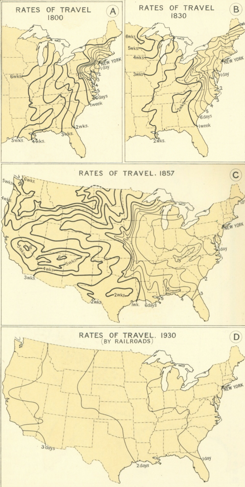
    1858_f857.png


  • Moderators, Recreation & Hobbies Moderators, Science, Health & Environment Moderators, Technology & Internet Moderators Posts: 90,747 Mod ✭✭✭✭Capt'n Midnight


  • Advertisement
  • Registered Users Posts: 5,733 ✭✭✭Duckworth_Luas


    I came across this video on YouTube after discovering the Canadian folk musician Stan Rogers, who is used as the background music.


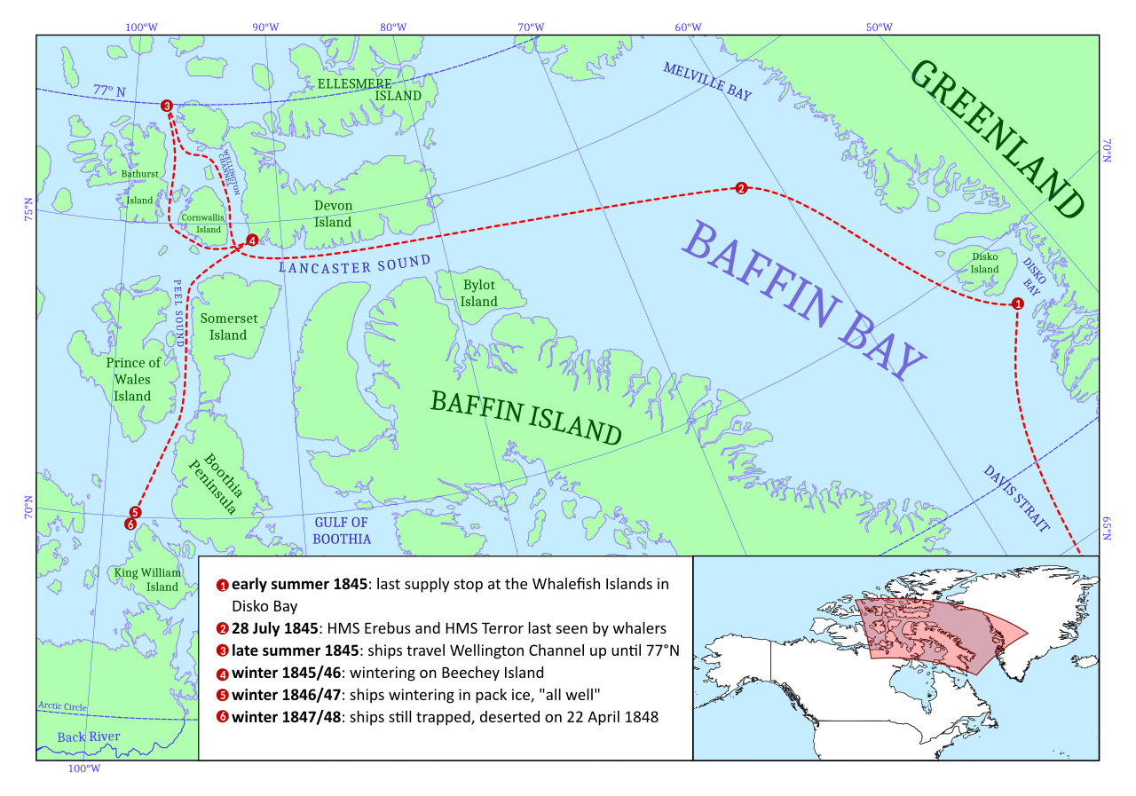
    It shows how the postulated Northwest Passage was finally proven to exist, piece by piece, through various voyages of discovery between 1500 and 1850.

    Fans of the TV series The Terror will see John Franklin's doomed route between 1845 and 1847 @ 4:06.
    1280px-Supposed_Route_of_Franklin%27s_expedition_1845-1848.svg.png
    Both ships on that voyage, Terror and Erebus, were abandoned in pack ice in 1848. All hands disappeared.

    Wexford born Robert McClure was sent as part of an expedition to search for Franklin, his route is @ 4:17. He did so by rounding Cape Horn and entering the passage from the west.

    Like Franklin, his ship became trapped in ice and a third expedition led by Belcher was sent to find both missing crews, entering from the east.

    He found McClure, whose crew were close to starvation, after all hands had abandoned ship and they returned home on Blecher's vessels.

    As a result McClure was given credit with being the first to fully navigate the passage, which was controversial due to his use of sledges to move between the two independent expeditions.

    The first person to successfully navigate the passage solely by ship was none other than Roald Amundsen in 1906.

    His route is shown below but is not in the video as all portions had been previously been discovered by other explorers.

    Northwest_Passage_Route_Time_Toast_picture.gif

    Amundsen's route was not commercially viable, but thanks to disappearing sea ice the more northerly and deeper waterways are opening up and the Chinese are particularly interested in using it in future.

    Yay for global warming!!!


  • Moderators, Recreation & Hobbies Moderators, Science, Health & Environment Moderators, Technology & Internet Moderators Posts: 90,747 Mod ✭✭✭✭Capt'n Midnight


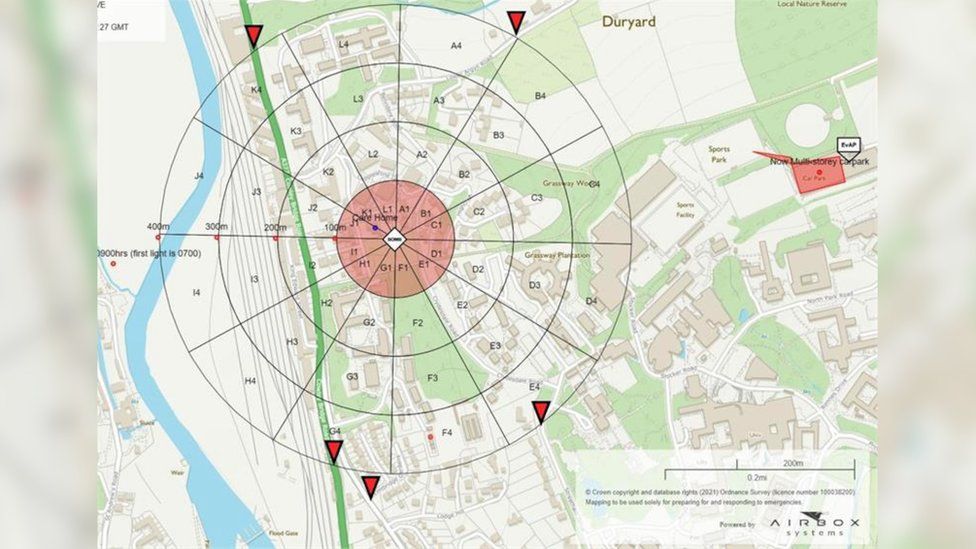
    Cordon area for a one tonne bomb in the UK

    _117317790_map.jpg

    The initial zone was 100m later expanded to 400m

    Video of explosion
    https://www.bbc.com/news/uk-england-devon-56229045
    Bomb disposal teams used 400 tonnes of sand to create an enclosing "box" before it was made safe just before 18:15 GMT on Saturday in an explosion heard up to five miles (8km) away.


  • Moderators, Recreation & Hobbies Moderators, Science, Health & Environment Moderators, Technology & Internet Moderators Posts: 90,747 Mod ✭✭✭✭Capt'n Midnight


    A German WW2 bomb dropped in 1944 made safe by bomb disposal experts in Exeter.

    That's one hell of a parachute :pac:


  • Registered Users Posts: 10,117 ✭✭✭✭Junkyard Tom


    Thought the people here would like this, it's got everything, a big bridge, a vital strip of territory that gives a would-be landlocked region access to the sea, EU, China and more.


  • Posts: 18,749 ✭✭✭✭ [Deleted User]


    I lived in the Balkans for a while, really liked it over there
    Those border crossings were painful though!


  • Advertisement
  • Registered Users Posts: 1,178 ✭✭✭MY BAD


    bubblypop wrote: »
    I lived in the Balkans for a while, really liked it over there
    Those border crossings were painful though!
    The crossing from Montenegro to Albania is painfully slow


  • Registered Users Posts: 9,364 ✭✭✭Shedite27


    Thought the people here would like this, it's got everything, a big bridge, a vital strip of territory that gives a would-be landlocked region access to the sea, EU, China and more.


    I realise it's never this simple but a tunnel could have solved this


  • Moderators, Arts Moderators, Recreation & Hobbies Moderators, Social & Fun Moderators Posts: 76,382 Mod ✭✭✭✭New Home


    A moving bridge would have also sorted it.


  • Registered Users Posts: 10,117 ✭✭✭✭Junkyard Tom


    In reality how many ships will it stop getting to a port that isn't even built to accept large vessels? I think it's more to do with losing a degree of control on Bosnia's part.


  • Moderators, Category Moderators, Arts Moderators, Sports Moderators Posts: 48,405 CMod ✭✭✭✭magicbastarder


  • Posts: 7,712 ✭✭✭ [Deleted User]


    Interesting map but an absolutely idiotic tweet accompanying it.


  • Posts: 0 [Deleted User]


    sxqomox8vsg41.png


  • Moderators, Category Moderators, Arts Moderators, Sports Moderators Posts: 48,405 CMod ✭✭✭✭magicbastarder


    Interesting map but an absolutely idiotic tweet accompanying it.
    i have a strong suspicion it's a joke.


  • Registered Users Posts: 34,044 ✭✭✭✭The_Kew_Tour


  • Registered Users Posts: 13,641 ✭✭✭✭josip


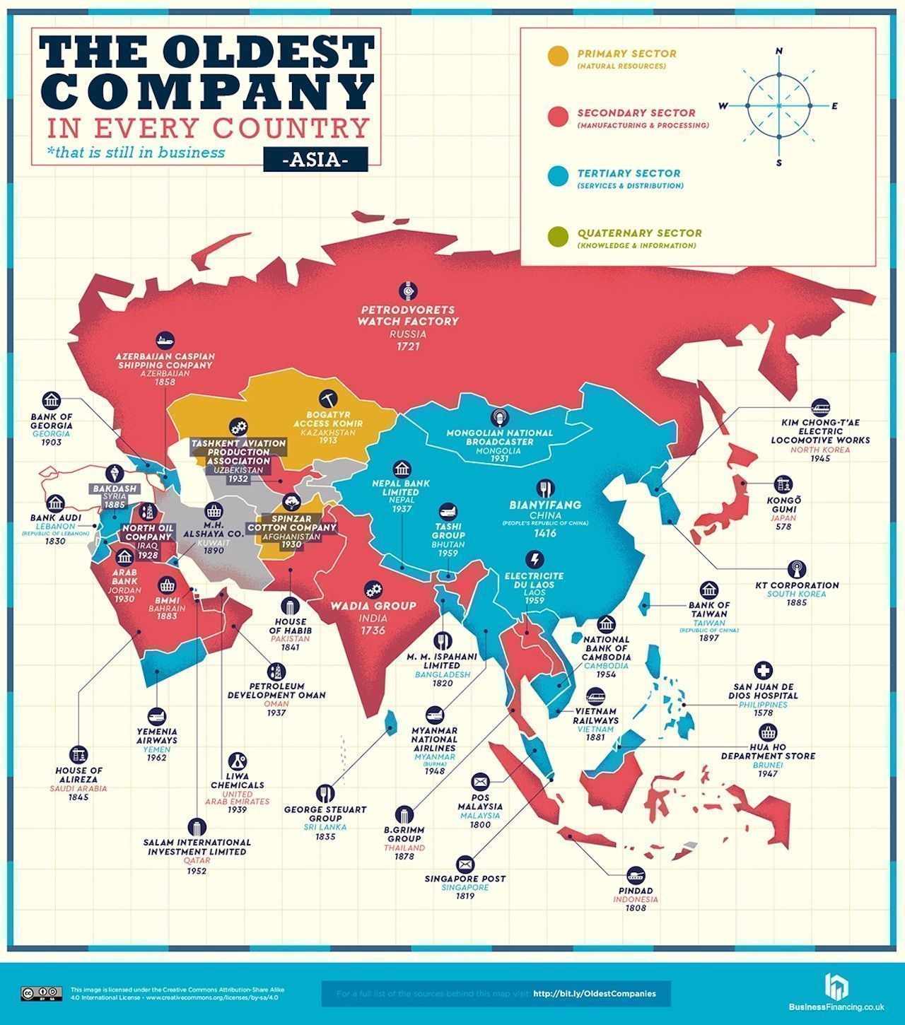
    "Oldest Company Map"


    Why does the Legend have an unused rage, 500-749 AD?
    The oldest I can find on the map is 803 in Austria.


  • Advertisement
  • Registered Users Posts: 18,923 ✭✭✭✭BonnieSituation


    josip wrote: »
    Why does the Legend have an unused rage, 500-749 AD?
    The oldest I can find on the map is 803 in Austria.

    There's other maps by the same crowd for around the world.

    There's a company in Japan that fits that range. I think it's either an onsen or a construction company.


  • Registered Users Posts: 6,457 ✭✭✭Badly Drunk Boy


    There's other maps by the same crowd for around the world.

    There's a company in Japan that fits that range. I think it's either an onsen or a construction company.

    Yeah, you're right.

    Map-of-Middle-East-and-Asia-Oldest-companies.jpg


  • Registered Users Posts: 19,728 ✭✭✭✭cnocbui


    New Home wrote: »
    A moving bridge would have also sorted it.

    It's a beat up by someone who doesn't want the bridge to connect the two regions, it's got nothing to do with shipping or a port, the thing has a 98m - 322' clearance under it! https://en.wikipedia.org/wiki/Pelje%C5%A1ac_Bridge

    The tallest existing ship is 50m in height, so that bridge has more than enough clearence for anything afloat.

    Typical childish balkan nonsense.


  • Moderators, Recreation & Hobbies Moderators, Science, Health & Environment Moderators, Technology & Internet Moderators Posts: 90,747 Mod ✭✭✭✭Capt'n Midnight


    map.png

    GPS ground stations , used to calibrate the orbits because it's based on knowing EXACTLY where the satellites will be at any given time.


  • Registered Users Posts: 1,168 ✭✭✭ypres5


    Cologne was hit with over 34,000 tons of bombs over 262 air raids from 1940 to 1945, almost exclusively by the RAF. 20,000 people killed.

    The only building to survive was the Cathedral, even though it was hit a few times. Here's a link to a high res image of the devastation (too big to embed).

    https://upload.wikimedia.org/wikipedia/commons/7/7f/Koeln_1945.jpg

    a friend of mine who lives in dusseldorf told me that when the war was over the government was almost considering not rebuilding köln and relocating everything to dusseldorf. it's a good thing they didn't follow through as kölns a beautiful city and the cathedral is stunning


  • Registered Users Posts: 16,114 ✭✭✭✭Pherekydes


    cnocbui wrote: »
    The tallest existing ship is 50m in height, so that bridge has more than enough clearence for anything afloat.

    There are cruise ships a lot taller than 50m.

    The Verrazzano-Narrows bridge has 69.5m clearance, and some cruise ships are unable to sail under it.


  • Registered Users Posts: 4,393 ✭✭✭KevRossi


    Marseilles European Cup was rescinded due to match fixing.
    cnocbui wrote: »
    It's a beat up by someone who doesn't want the bridge to connect the two regions, it's got nothing to do with shipping or a port, the thing has a 98m - 322' clearance under it! https://en.wikipedia.org/wiki/Pelje%C5%A1ac_Bridge

    The tallest existing ship is 50m in height, so that bridge has more than enough clearence for anything afloat.

    Typical childish balkan nonsense.


    The clearance from the bridge to the water is 55m. The bridge height from the bottom of the sea is 98m.

    The 'Golden Gate Bridge' height and the 'Panama Canal' width were the two given dimensions for ships for the past century or so. This bridge deliberately undercuts it. It is possible that many ships built in the future will not be able to fit under it. Many cruise ships cannot.

    Ships are getting bigger, some can no longer fit into the Panama Canal, but the owners take this into account when ordering it. The Croats can now effecitvely cause issues with Bosnia when they use Ploce harbour.

    That the EU funded a bridge that can be used as a pawn in the future in a region with a terrible history of conflict is madness, they should have insisted on a 67m height if they wanted the money.


  • Registered Users Posts: 9,364 ✭✭✭Shedite27


    KevRossi wrote: »
    The clearance from the bridge to the water is 55m. The bridge height from the bottom of the sea is 98m.

    The 'Golden Gate Bridge' height and the 'Panama Canal' width were the two given dimensions for ships for the past century or so. This bridge deliberately undercuts it. It is possible that many ships built in the future will not be able to fit under it. Many cruise ships cannot.

    Ships are getting bigger, some can no longer fit into the Panama Canal, but the owners take this into account when ordering it. The Croats can now effecitvely cause issues with Bosnia when they use Ploce harbour.

    That the EU funded a bridge that can be used as a pawn in the future in a region with a terrible history of conflict is madness, they should have insisted on a 67m height if they wanted the money.
    The Bosnian harbour looks like it would have trouble accommodating the the Passage West ferry, I don’t think they’re anything to worry about


  • Registered Users Posts: 13,641 ✭✭✭✭josip


    Shedite27 wrote: »
    The Bosnian harbour looks like it would have trouble accommodating the the Passage West ferry, I don’t think they’re anything to worry about


    The Bosnians should buy an old Oasis-class Cruise liner on the cheap, reinforce the upper decks and bump it into the bridge a few times if they ever complete it.


  • Advertisement
  • Registered Users Posts: 19,728 ✭✭✭✭cnocbui


    Pherekydes wrote: »
    There are cruise ships a lot taller than 50m.

    The Verrazzano-Narrows bridge has 69.5m clearance, and some cruise ships are unable to sail under it.

    I checked wikipedia and it referenced the Sunbird, which is yet to be built and an article on that mislead me:
    The Oceanbird measures roughly 656 ft (200 m) in length and 131 ft (40 m) wide. It is designed to have a displacement of roughly 35,273 tons (32,000 tonnes) and, with its massive extendable sails at full height, will be 328 ft (100 m) tall — that is twice the height of the tallest existing ship.
    https://interestingengineering.com/swedish-consortium-unveils-wind-powered-car-carrier-with-towering-wings

    Maybe they meant sailing ship?


Advertisement