Advertisement
Help Keep Boards Alive. Support us by going ad free today. See here: https://subscriptions.boards.ie/.
If we do not hit our goal we will be forced to close the site.

Current status: https://keepboardsalive.com/

Annual subs are best for most impact. If you are still undecided on going Ad Free - you can also donate using the Paypal Donate option. All contribution helps. Thank you.
https://www.boards.ie/group/1878-subscribers-forum

Private Group for paid up members of Boards.ie. Join the club.

Interesting Maps

1374375376377379

Comments

  • Moderators, Recreation & Hobbies Moderators, Science, Health & Environment Moderators, Technology & Internet Moderators Posts: 96,212 Mod ✭✭✭✭Capt'n Midnight


    image.png

    Sea levels.

    image.png

    https://i.imgur.com/yZSLP2s.jpeg


  • Moderators, Recreation & Hobbies Moderators, Science, Health & Environment Moderators, Technology & Internet Moderators Posts: 96,212 Mod ✭✭✭✭Capt'n Midnight


  • Moderators, Recreation & Hobbies Moderators, Science, Health & Environment Moderators, Technology & Internet Moderators Posts: 96,212 Mod ✭✭✭✭Capt'n Midnight


  • Moderators, Social & Fun Moderators, Paid Member Posts: 14,031 Mod ✭✭✭✭JupiterKid


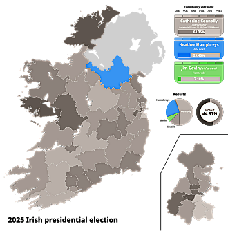
    Map of first count results of the 2025 Presidential election

    330px-2025_Irish_presidential_election_-_Map.svg.png

    Catherine Connolly, the President-elect, won a clear majority in all constituencies with the exception of Cavan-Monaghan which opted for local TD Heather Humphries.

    Turnout was 45% of the electorate.

    Post edited by JupiterKid on


  • Moderators, Recreation & Hobbies Moderators, Science, Health & Environment Moderators, Technology & Internet Moderators Posts: 96,212 Mod ✭✭✭✭Capt'n Midnight


  • Advertisement
  • Registered Users, Registered Users 2 Posts: 878 ✭✭✭minggatu


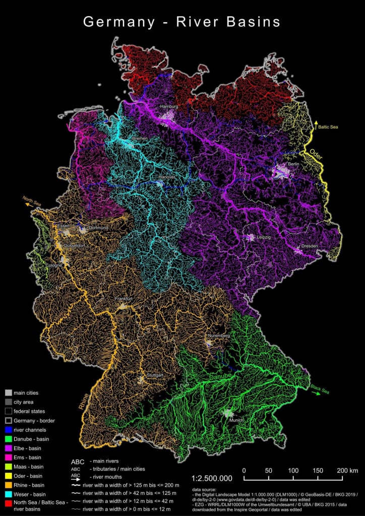
    River basin map of Germany river-basin-map-of-germany.jpg

    https://mapsontheweb.zoom-maps.com/posts/watersheds/river-basin-map-of-germany


  • Registered Users, Registered Users 2 Posts: 14,874 ✭✭✭✭joujoujou
    Unregistered Users


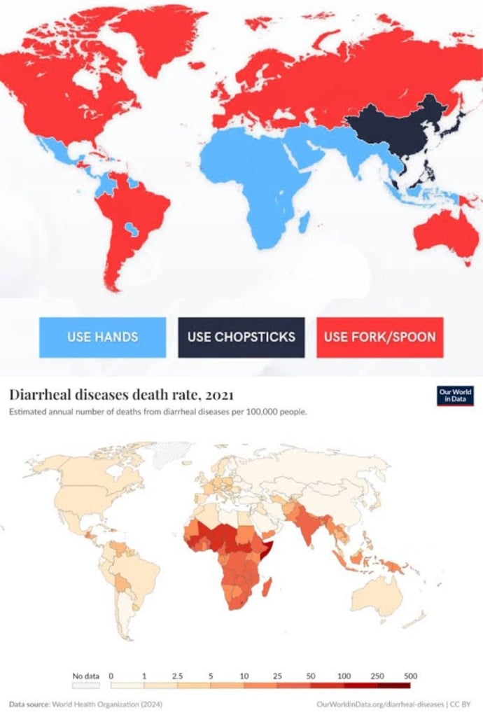
    G4KydSOWcAAYu2k.jpg

    ..


  • Moderators, Arts Moderators, Recreation & Hobbies Moderators, Social & Fun Moderators Posts: 79,585 Mod ✭✭✭✭New Home


    Now do a map with the quality of water/access to clean water/ hand hygiene, just for comparison.


  • Registered Users, Registered Users 2 Posts: 14,874 ✭✭✭✭joujoujou
    Unregistered Users


    There's more that one on wikipedia - water scarcity it's called. Both physical and economical. :-P

    Back to the maps:

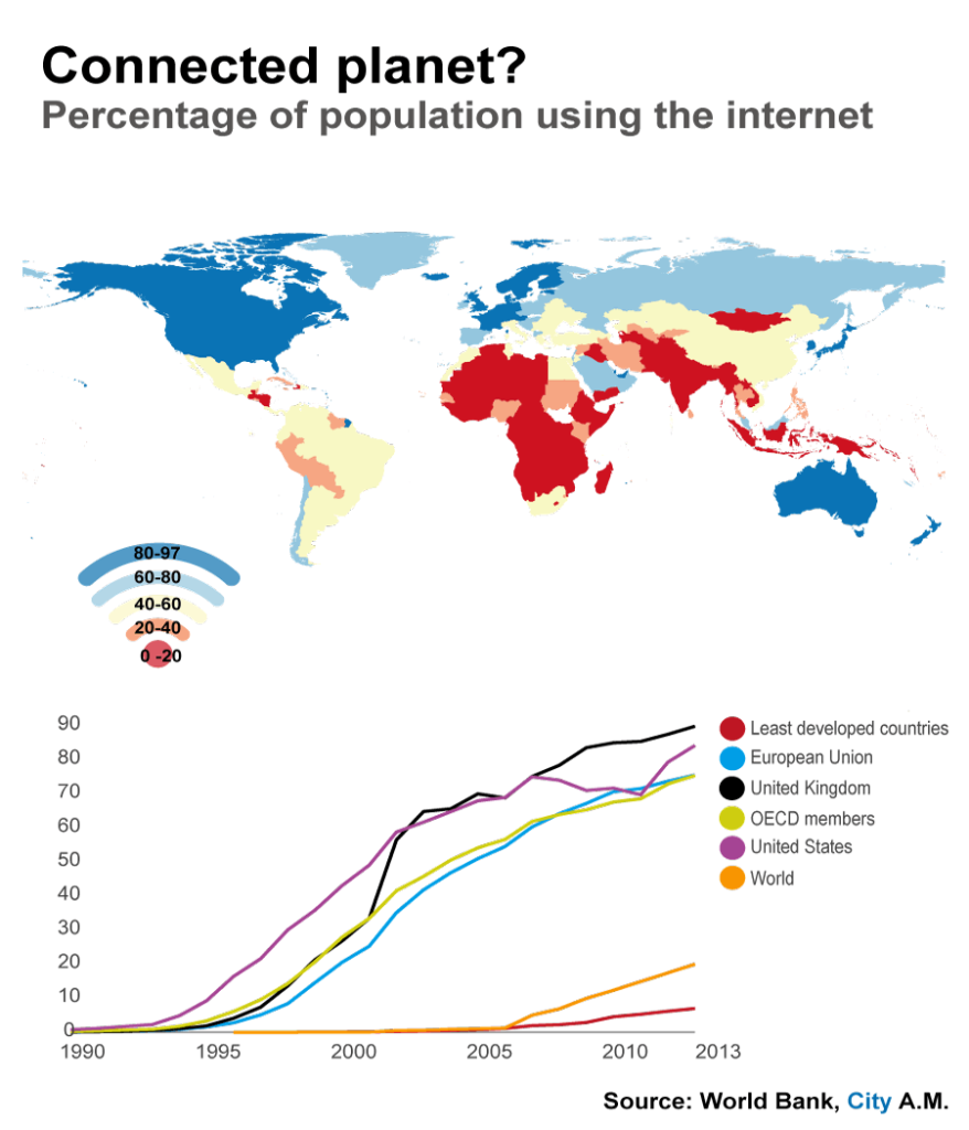
    150120-world-internet-3-57edacfec3daf.png


  • Registered Users, Registered Users 2 Posts: 6,538 ✭✭✭yagan


    I did the usual backpacker thing around SE asia decades ago but even then aside from Myanmar, Cambodia and Laos the rest of the countries seemed to a combination of fork/spoon and/or chopsticks.

    I certainly don't recall eating with hands being a thing in Thailand, it was fork and spoon all the way. Maybe in rural Thailand they might dab food with sticky rice like is common in Laos.

    But I'll never forget the little plastic bags of deep fried spiders and bugs in Cambodia that people would munch on like popcorn.


  • Advertisement
  • Registered Users, Registered Users 2 Posts: 878 ✭✭✭minggatu


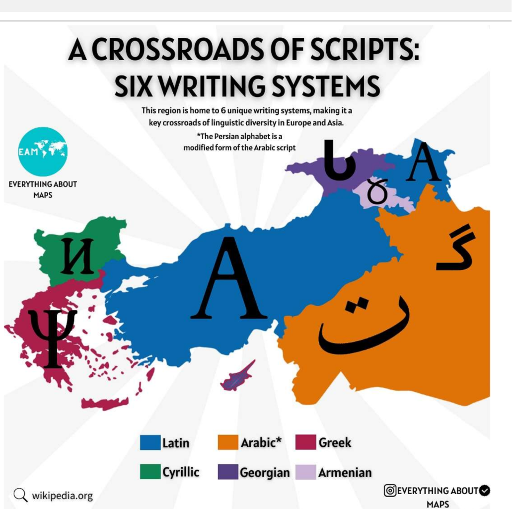
    Writing systems used by neighboring countries around Turkey grafik.png

    "

    A Crossroads of Scripts: Six Writing Systems Across Europe and Asia This map highlights one of the most linguistically diverse regions in the world, where six distinct writing systems coexist in close geographical proximity. Stretching from Southeastern Europe into Western and Central Asia, this area forms a true crossroads of scripts. "


  • Registered Users, Registered Users 2 Posts: 1,886 ✭✭✭rock22


    But is each of them not just a variation of the Phoenician script?


  • Registered Users, Registered Users 2 Posts: 10,301 ✭✭✭✭Quantum Erasure


    Back to the maps: internet use 2013

    I'm guessing use has shot up in India at least over the last 12 years


  • Registered Users, Registered Users 2 Posts: 878 ✭✭✭minggatu


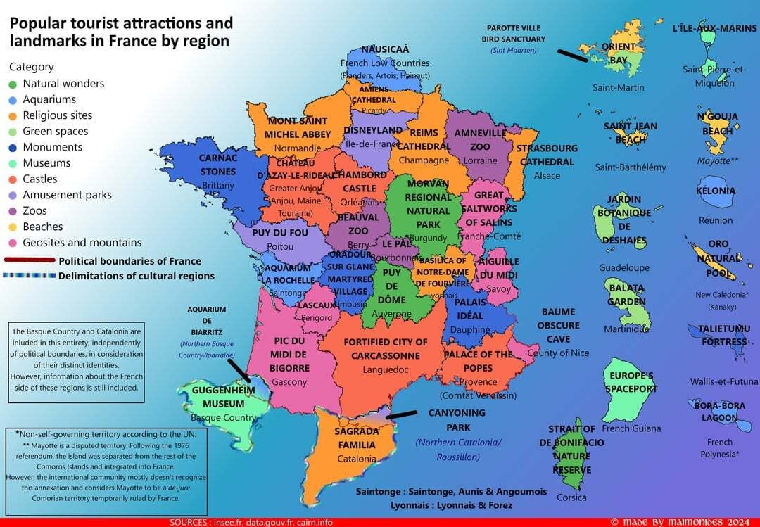
    Popular tourist attractions and landmarks in France by region popular-tourist-attractions-and-landmarks-in-france-by-v0-x5gbr07x5bgd1.jpeg

    https://www.reddit.com/r/Maps/comments/1eik1qm/oc_popular_tourist_attractions_and_landmarks_in/#lightbox


  • Registered Users, Registered Users 2 Posts: 14,874 ✭✭✭✭joujoujou
    Unregistered Users


    ^^ Looks like France extended its borders a bit? ;-)


  • Registered Users, Registered Users 2 Posts: 8,061 ✭✭✭Gaspode


    Info on that in the key


  • Registered Users, Registered Users 2 Posts: 878 ✭✭✭minggatu


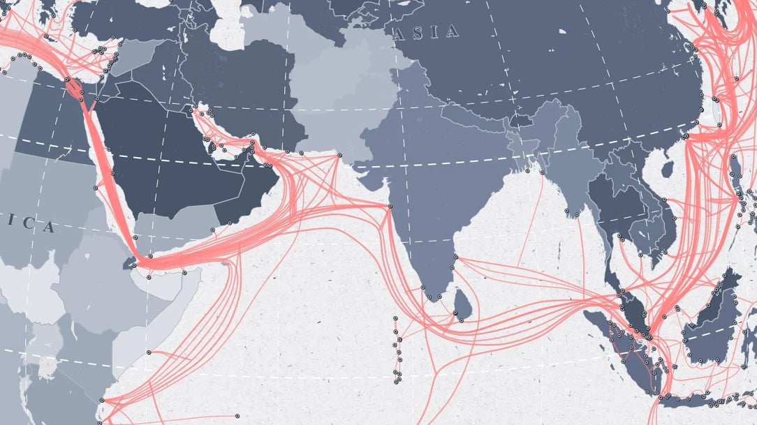
    The Underwater Cables That Connect the World article-staying-connected-featured.jpg

    https://www.maps.com/submarine-cables-map-shows-global-internet-infrastructure/


  • Registered Users, Registered Users 2 Posts: 878 ✭✭✭minggatu


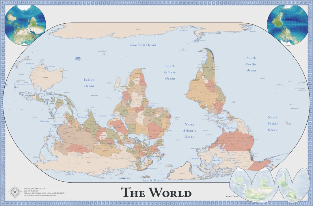
    This Map Is Not Upside Down

    "

    Our conventions as map readers and makers have converged over time to a north-up default. What happens when that convention is challenged? "

    simmon-south-up-map-full.jpg


  • Registered Users, Registered Users 2 Posts: 41,124 ✭✭✭✭ohnonotgmail


  • Registered Users, Registered Users 2 Posts: 6,714 ✭✭✭marcbrophy


    I kinda like this map, not for it's orientation, but because you can see more water.

    The fact there's 70% of the surface is covered with it, but the Mercator projection makes it hard to visualise that!
    It seems to hide a lot of the Pacific, imo.


  • Advertisement
  • Registered Users, Registered Users 2 Posts: 878 ✭✭✭minggatu


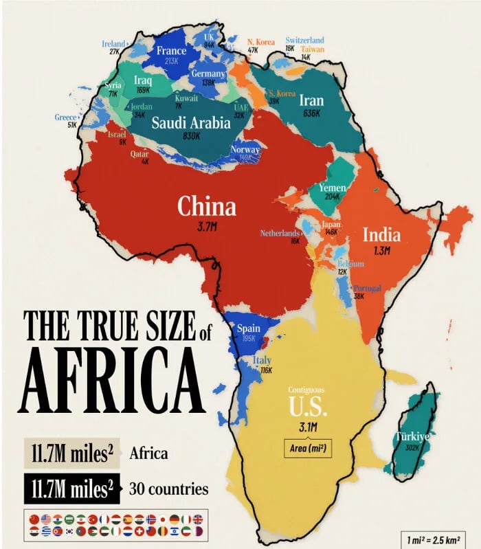
    True size of Africa

    68cfcdc1cd1bd_aux0eb57rfqf1-png__700(1).jpg


  • Moderators, Social & Fun Moderators, Paid Member Posts: 14,031 Mod ✭✭✭✭JupiterKid


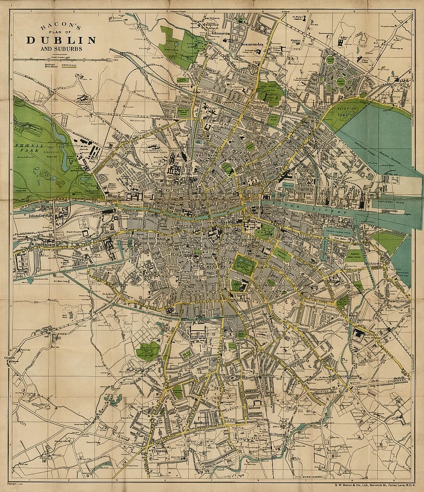
    Bacon's street plan of Dublin and suburbs, 1929

    Dublin-bacon-1926.jpg


  • Moderators, Social & Fun Moderators, Paid Member Posts: 14,031 Mod ✭✭✭✭JupiterKid


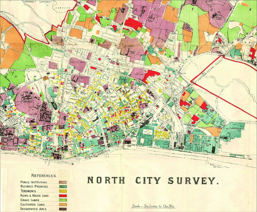
    Dublin north city survey, 1918

    Extract-from-land-use-map-of-Dublin-north-city-in-1918-Dublin-Corporation-Survey-of-the.png

    Note the concentration of land use categorised as tenements (slums) in the north inner city.


  • Moderators, Social & Fun Moderators, Paid Member Posts: 14,031 Mod ✭✭✭✭JupiterKid


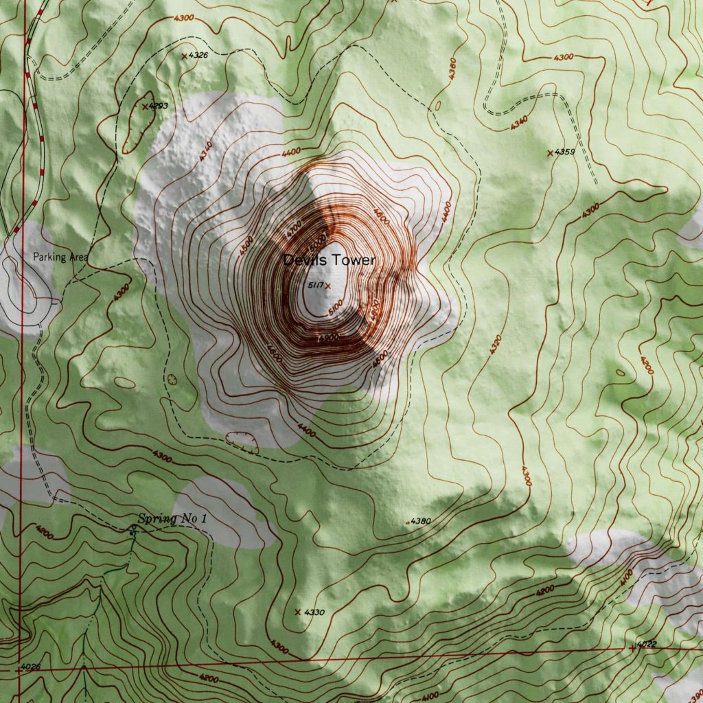
    Topographic map of Devil's Tower national monument in northeast Wyoming, USA

    Elevation is in feet

    Devils-Tower-Map.jpg


  • Registered Users, Registered Users 2 Posts: 878 ✭✭✭minggatu


  • Registered Users, Registered Users 2 Posts: 878 ✭✭✭minggatu


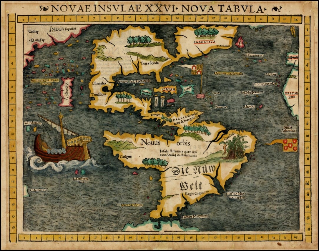
    Novae Insulae XXVI Nova Tabula, The Americas, Sebastian Münster, (1540) hbxcfueaf3xf1.jpeg

    https://www.reddit.com/r/oldmaps/comments/1of3nek/novae_insulae_xxvi_nova_tabula_the_americas/


  • Registered Users, Registered Users 2, Paid Member Posts: 30,103 ✭✭✭✭Quazzie


    According to a quick google search Antarctica was first seen in 1820, so how is it on that map from 1540?


  • Registered Users, Registered Users 2 Posts: 78,850 ✭✭✭✭Victor


    It would seem that people knew of 'land' to the south before that.

    "Although James Cook is believed to have reached some islands off the Antarctic coast in 1773, the actual continent wasn't reached until 1820."

    1820: "January 1820: Antarctica is 'first sighted' by European explorers"

    "Russian explorer Fabian von Bellingshausen reported sighting an "ice shore" on January 27 or 28, while British officer Edward Bransfield saw mountains on the mainland, the Antarctic Peninsula, on January 30."

    "The controversy over whether it was Irishman, Edward Bransfield or the Russian Fabian von Bellingshausen, who first set eyes on the Antarctic mainland in 1820"

    "Edward Bransfield—the Corkman who discovered Antarctica"


  • Moderators, Recreation & Hobbies Moderators, Science, Health & Environment Moderators, Technology & Internet Moderators Posts: 96,212 Mod ✭✭✭✭Capt'n Midnight


    UK feet (Queen Anne's) or US feet or US metric feet ( 1 inch=2.54cm) or US geographical survey feet ? (Defunct since 1/1/2023)


  • Advertisement
  • Moderators, Recreation & Hobbies Moderators, Science, Health & Environment Moderators, Technology & Internet Moderators Posts: 96,212 Mod ✭✭✭✭Capt'n Midnight


    It was assumed there would be land there. But they didn't think it would be so far south.


Advertisement