Advertisement
If you have a new account but are having problems posting or verifying your account, please email us on hello@boards.ie for help. Thanks :)
Hello all! Please ensure that you are posting a new thread or question in the appropriate forum. The Feedback forum is overwhelmed with questions that are having to be moved elsewhere. If you need help to verify your account contact hello@boards.ie

Dublin Metrolink (just Metrolink posts here -see post #1 )

Options
15657596162314

Comments

  • Registered Users Posts: 9,275 ✭✭✭cgcsb


    monument wrote: »
    I don't know of any party which has Metro North high on their agenda, so could you please share with us which ones you're talking about?

    It's only been mentioned in 7 Dail debates this year and the bulk of those mentions are from FG or FF: http://www.kildarestreet.com/search/?s=%22Metro+north%22


    That is mainly blue sky because that route is mainly areas with a far from ideal population density to support the cost of an underground metro. And there's very few trip generators along the route.

    At least MN more density and trip generators such as the airport, major hospitals, a rail/Dart connection, a university, a large stadium etc.

    South West Dublin is very densely populated, Harold's X, Rathmines, Terenure etc. And that part of Dublin lacks a large radial road route so a metro line would be a popular alternative imo. The roads are narrow and traffic is terrible in that part of the city.


  • Registered Users Posts: 9,275 ✭✭✭cgcsb


    Yeah, fair enough, perhaps Luas and BRT is a better option for those areas. When I lived there if you got the right bus going up Clanbrassil St/Patrick St it was a very quick journey into town. I've read the feasibility study into a Luas line down the Harold's Cross road, I think the conclusion was it doesn't pass a cost/benefit analysis.

    I fully support building MN as currently designed, BTW, it is badly needed.

    It didn't pass CBA primarily for engineering reasons, i.e. it'd take a lot of road space, would have to share large sections with private cars, would be impossible to get past Christ church and service would generally be slow. An underground alternative may well perform much better.


  • Registered Users Posts: 19,018 ✭✭✭✭murphaph


    The authorities seem set on this cross-city luas line, presumably because of lack of cash at the moment, and they want to do something to improve Dublin's transport.
    My own view is perhaps more controversial. I think the RPA would build anything that they can get funding for, rather than saying "hey, this is crazy and not in any way future proofed". At the end of the day the RPA are people. People need a wage.

    Here we rely on government ultimately to make the right decisions, but if the RPA are "advising" government to build a cheapo version of XYZ then.....

    Imagine a Dublin with Finglas-Cherrywood, Hazelhatch-Malahide, Maynooth.Bray and Swords-Tallaght rapid transit links: different world, normal even. Will never happen unfortunately. We'll probably get around to building all these tunnels when personal jet cars are the norm elsewhere :rolleyes:


  • Closed Accounts Posts: 1,844 ✭✭✭Banjoxed


    There have been plenty of squandered opportunities in transport planning over the last forty years but one of the worst has to be the destruction of the once reserved route from Mount Argus to Tallaght that as far back as the DRRTS was set aside for a time as a busway. Instead crucial parts of it got built on, at a time when the received wisdom was that unreliable Atlanteans on an alphabet soup of route variants was touted as the "cost effective" alternative to the Rapid Transit proposals. At least we got west side suburban rail and Luas in the teeth of that dismal mentality.


  • Registered Users Posts: 19,018 ✭✭✭✭murphaph


    monument wrote: »
    You see how hard it is for MN to progress but you think both MN and a Broadstone-Harcourt tunnel are possible?
    Practically very possible. Politically impossible as Dublin MUST be starved of infrastructure to keep most of the country happy! Other cities (like Liverpool and Glasgow, nevermind countless continental examples) have linked such alignments years ago.
    monument wrote: »
    Where would the tunnel portals for this Broadstone-Harcourt tunnel be? A bus depot area which is at least partly -- the middle of it -- up for redevelopment? And the golf club at Milltown? Or is anybody suggesting a tunnel portal at the green???

    If it's Milltown the distance isn't all that short after all, if it's the green the suggestion is madness.
    It's not madness at all for the line to dive underground as it runs along the side of the Green. Several U Bahn lines in Berlin run ELEVATED and then dive underground in the space of a few hundred yards. Easily done tbh. You could even start diving under along Harcourt street and "go deep" along side the Green. Check out the gradient of the Luas ramp at Peter Place to see how quickly you can get a tram underground, and that's on a curve.


  • Advertisement
  • Registered Users Posts: 19,018 ✭✭✭✭murphaph


    Banjoxed wrote: »
    There have been plenty of squandered opportunities in transport planning over the last forty years but one of the worst has to be the destruction of the once reserved route from Mount Argus to Tallaght that as far back as the DRRTS was set aside for a time as a busway. Instead crucial parts of it got built on, at a time when the received wisdom was that unreliable Atlanteans on an alphabet soup of route variants was touted as the "cost effective" alternative to the Rapid Transit proposals. At least we got west side suburban rail and Luas in the teeth of that dismal mentality.
    Is there any of the reserved alignment left visible from google maps?


  • Registered Users Posts: 2,677 ✭✭✭AngryLips


    murphaph wrote: »
    I think the RPA would build anything that they can get funding for

    Well they're hardly able to build something that they can't get funding for... :rolleyes:


  • Registered Users Posts: 19,018 ✭✭✭✭murphaph


    AngryLips wrote: »
    Well they're hardly able to build something that they can't get funding for... :rolleyes:
    Did you deliberately misunderstand my post?


  • Closed Accounts Posts: 1,844 ✭✭✭Banjoxed


    murphaph wrote: »
    Is there any of the reserved alignment left visible from google maps?

    Good question. Think the route basically ran beside the Poddle. From memory it was on the Development Plan in the 80s and then it wasn't.


  • Closed Accounts Posts: 1,844 ✭✭✭Banjoxed


    murphaph wrote: »
    Practically very possible. Politically impossible as Dublin MUST be starved of infrastructure to keep most of the country happy! Other cities (like Liverpool and Glasgow, nevermind countless continental examples) have linked such alignments years ago.


    It's not madness at all for the line to dive underground as it runs along the side of the Green. Several U Bahn lines in Berlin run ELEVATED and then dive underground in the space of a few hundred yards. Easily done tbh. You could even start diving under along Harcourt street and "go deep" along side the Green. Check out the gradient of the Luas ramp at Peter Place to see how quickly you can get a tram underground, and that's on a curve.

    It's doable but would be a lot of cut and cover. Remember reading this and laughing at the assumption that invisible moles would be digging evaporating spoil:


  • Advertisement
  • Moderators, Motoring & Transport Moderators Posts: 14,072 Mod ✭✭✭✭monument


    cgcsb wrote: »
    South West Dublin is very densely populated, Harold's X, Rathmines, Terenure etc. And that part of Dublin lacks a large radial road route so a metro line would be a popular alternative imo. The roads are narrow and traffic is terrible in that part of the city.

    The area around the suggested route is not very densely populated: See here: http://www.boards.ie/vbulletin/showthread.php?t=2056341438 -- note on the map with the railway lines included that the Luas Rathfarnham would / could take a sharp turn just after the density drops.

    And there's far fewer notable trip generators.

    Whatever about population density, the south-west route is densely covered by houses with fairly large gardens which makes densely infill a good deal harder than the northside (which is already littered with a surprising amount of infill an has more unused or underdeveloped sites which is more likely to be developed.


    Banjoxed wrote: »
    There have been plenty of squandered opportunities in transport planning over the last forty years but one of the worst has to be the destruction of the once reserved route from Mount Argus to Tallaght that as far back as the DRRTS was set aside for a time as a busway. Instead crucial parts of it got built on, at a time when the received wisdom was that unreliable Atlanteans on an alphabet soup of route variants was touted as the "cost effective" alternative to the Rapid Transit proposals. At least we got west side suburban rail and Luas in the teeth of that dismal mentality.

    Our lack of ability to think ahead and reserve potential route -- even if some will not be used for 60 years -- is very unfortunate.


  • Moderators, Motoring & Transport Moderators Posts: 14,072 Mod ✭✭✭✭monument


    murphaph wrote: »
    Practically very possible. Politically impossible as Dublin MUST be starved of infrastructure to keep most of the country happy! Other cities (like Liverpool and Glasgow, nevermind countless continental examples) have linked such alignments years ago.

    And I'm sure you can guess that I'm talking politically. :)
    murphaph wrote: »
    It's not madness at all for the line to dive underground as it runs along the side of the Green. Several U Bahn lines in Berlin run ELEVATED and then dive underground in the space of a few hundred yards. Easily done tbh. You could even start diving under along Harcourt street and "go deep" along side the Green. Check out the gradient of the Luas ramp at Peter Place to see how quickly you can get a tram underground, and that's on a curve.

    If it could, as you say, dive underground at the end of Harcourt Street, that would not be as bad as leaving a hole beside the green.

    But you're still dealing with a strong lobby of people who were set against the DU/MN station works on the green and your idea would still require quite large works for a tunnel portal along the west side of the green -- this might not leave any long-term impact but just like the DU/MN station boxes, there will be people who care very strongly about the short-mid term.

    Also once BXD goes ahead, err... which is starting to happen now, there will be a reluctance to mess with the longer green line and businesses in the area will have had enough for a long time.

    murphaph wrote: »
    Is there any of the reserved alignment left visible from google maps?

    The Poddle? Yes. But's it narrow as there's lots of things and walls built right up and around the river.

    Here's Google Maps with the river pictured if you want to follow it into the city. Even a greenway could be a big challenge, never might about BRT...

    The NTA are now suggesting using it as a greenway -- or at least it's in the GDA draft cycle network as one.

    The NTA BRT plans seems follow the Poddle, but the maps are unclear and it seems like it could be following parallel residential roads -- this kind of thing works in places like Utrecht, and it would be lesser challenge than trying to follow the river!


  • Closed Accounts Posts: 879 ✭✭✭TheBandicoot


    Banjoxed wrote: »
    It's doable but would be a lot of cut and cover. Remember reading this and laughing at the assumption that invisible moles would be digging evaporating spoil:

    Wow, this is depressing, makes you lose faith in this entire country. What an unbelievably short sighted and car-centric attitude.


  • Registered Users Posts: 7,528 ✭✭✭GerardKeating


    I would much rather see Metro North extended by heading South-West and tunnelling under the likes of Rathmines, Harold's Cross, Terenure, Templogue out to Tallaght, but this is all blue sky stuff.

    Which was the route of "Metro South" before it disappered from the plans ..

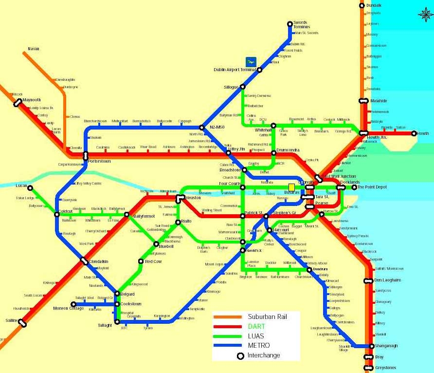
    DublinPlanMetro&LUAStram.G.jpg


  • Closed Accounts Posts: 1,844 ✭✭✭Banjoxed


    Wow, this is depressing, makes you lose faith in this entire country. What an unbelievably short sighted and car-centric attitude.

    Think the killer bit in that article is the blatant shyteology about closing streets to pedestrians because of Luas. How anyone took that seriously at the time beggars belief.


  • Registered Users Posts: 66 ✭✭metrostation


    Just stumbled upon this thread so i thought i would throw in my tupence worth :)

    I know this was looked at before but now with metro north plans condemned to the dustbin for the next 20-30 years maybe it is time to look at a luas line from the city centre out towards the airport and onwards to swords.

    The new luas line could link into the cross city line after cabra stop at the back of shandon with a substantial sized bridge needed to cross the canal and existing railway tracks cutting through lands owned by st vincents (this would need to be procured from the dept. of education) then onto the finglas road turning at prospect avenue heading up towards the ballymun road.

    This could go on through ballymun with a bridge needed at the ballymun cross m50 junction heading towards the airport.After stopping at the airport it could head up the old Dublin road towards pinock hill eventually stopping at the auburn rounabout with a park and ride terminal servicing the swords area.

    No expensive tunneling needed, it would simply use existing roads and un-used lands with two major bridges required.It could probably all be done for a tiny fraction of the cost of the metro north project.

    The stops would look something like this; Cabra - Glasnevin - Botanic - Griffith avenue - DCU - Ballymun - Santry - Airport T1 - Airport T2 - Swords

    I have attached a rough sketch below as you can see it follows a similar route to the metro north line with the added benefit of serving highly populated ares of Glasnevin, Ballymun and Swords as well as providing a direct link from the airport to the city centre.

    Airport luas.png


  • Banned (with Prison Access) Posts: 75 ✭✭cabrasnake


    Delusional


  • Registered Users Posts: 66 ✭✭metrostation


    cabrasnake wrote: »
    Delusional

    Care to elaborate on that?


  • Moderators, Motoring & Transport Moderators Posts: 14,072 Mod ✭✭✭✭monument


    Care to elaborate on that?

    I'm guessing he means that your route is delusional given the amount of narrow and/or busy roads you've chosen to use. And there'd be other issues, but the roads issue is so large it's not worth detailing anything else.

    Something like the following with a higher degree of segregation would be more practical*:

    * still requires larger scale Dundrum-like bridge with more support building needed; CPO and demolition of 6-20 houses (something state agencies here are strongly against it seems) and reallocation of road space.

    274631.JPG


    Or the following -- if possible -- would not require demolition:

    274632.JPG


  • Registered Users Posts: 66 ✭✭metrostation


    While the path you have chosen above is certainly more practical (from a procurement and construction point of view) taking this route could potentially add another 15 minutes onto the journey time, so rather than taking 30 minutes to get from airport to the city centre you have a journey that takes 45 minutes, people are not going to buy into that.

    With regards to the route taken, previous luas projects have shown that these lines can certainly work on narrow streets and busy roadways, its what makes the system workable.


  • Advertisement
  • Moderators, Motoring & Transport Moderators Posts: 14,072 Mod ✭✭✭✭monument


    While the path you have chosen above is certainly more practical (from a procurement and construction point of view) taking this route could potentially add another 15 minutes onto the journey time, so rather than taking 30 minutes to get from airport to the city centre you have a journey that takes 45 minutes, people are not going to buy into that.

    Which route would add 15 minutes? Compared to what?

    Which route would just be 30 minutes to the airport?

    The route I outlined is mainly more practical from a service reliability point-of-view and traffic disruption (traffic = cars, buses, trucks, cyclists). There's no major engineering or construction issues with your route, the problem is the lack of space to segregation.

    I should stress: These are routes which I've outlined. I'm not really suggesting such should be used, just I'm giving more practical ways of getting from Broombridge to the Ballymun Road.

    With regards to the route taken, previous luas projects have shown that these lines can certainly work on narrow streets and busy roadways, its what makes the system workable.

    Sorry, but that's just not the case. Even the red line has a reasonable level of segregation from traffic, and you're suggesting routes where there is no room for that.

    The narrow streets used in the city centre had very close by parallel routes -- the same is not the case for your route which includes Botanic Road, the narrowest section of the Finglas Road, and Hart's Corner.


  • Registered Users Posts: 66 ✭✭metrostation


    monument wrote: »
    Which route would add 15 minutes? Compared to what?

    Which route would just be 30 minutes to the airport?

    The route I outlined is mainly more practical from a service reliability point-of-view and traffic disruption (traffic = cars, buses, trucks, cyclists). There's no major engineering or construction issues with your route, the problem is the lack of space to segregation.

    I should stress: These are routes which I've outlined. I'm not really suggesting such should be used, just I'm giving more practical ways of getting from Broombridge to the Ballymun Road.


    Sorry, but that's just not the case. Even the red line has a reasonable level of segregation from traffic, and you're suggesting routes where there is no room for that.

    The narrow streets used in the city centre had very close by parallel routes -- the same is not the case for your route which includes Botanic Road, the narrowest section of the Finglas Road, and Hart's Corner.

    It would be no more of a distruption than the route they have chosen for the cross city line through vital parts of our city centre roads (which will require traffic system changes),yeah the route i have chosen will cause traffic changes and will need to do away with some bus lanes, but the benefits will far outweigh the negatives i believe.


  • Moderators, Motoring & Transport Moderators Posts: 14,072 Mod ✭✭✭✭monument


    It would be no more of a distruption than the route they have chosen for the cross city line through vital parts of our city centre roads (which will require traffic system changes),yeah the route i have chosen will cause traffic changes and will need to do away with some bus lanes, but the benefits will far outweigh the negatives i believe.

    Yes, there would be more disruption.

    The most restrictive section of Luas Cross City is the section of route along College Green - Nassau Street - Dawson Street and that is already operating under a bus gate at peak times and that's likely to be extended to a 24 hours bus gate once the Luas comes in. There'll also be extra turning restrictions (such as no right turn from the north end of Dawson Street).

    As for bus lanes around Hart's Corner: There's was only a singe bus lane along Prospect Avenue and for something like just 1/3 of Botanic Road (north of Prospect Ave) before it narrows, and then you have about another 300m of the narrower section of Mobhi Rd without a bus lane and the rest of Mobhi Rd has a single bus lane at best.

    Are you suggesting trams going two-way on one track? And shared Luas and traffic on an arterial route? Otherwise you're talking about mass bus and traffic lane removal and that does seem delusional.

    That's not to mention ripping along a school's pitch, ~80m of a small residential road which is the access to the same school, the idea of heavy disruption on key junctions, a bucket load of minor junctions...

    It all sounds like a lot of bother for 2km of road you could avoid.

    By the way, re distance: The shorter route I outlined is shorter than your suggestion and the longer one is just 0.2km longer than your idea. But both of the routes I outlined would be faster and more reliable given the higher degree of segregation.


  • Registered Users Posts: 1,419 ✭✭✭Cool Mo D


    monument wrote: »
    Yes, there would be more disruption.

    The most restrictive section of Luas Cross City is the section of route along College Green - Nassau Street - Dawson Street and that is already operating under a bus gate at peak times and that's likely to be extended to a 24 hours bus gate once the Luas comes in. There'll also be extra turning restrictions (such as no right turn from the north end of Dawson Street).

    As for bus lanes around Hart's Corner: There's was only a singe bus lane along Prospect Avenue and for something like just 1/3 of Botanic Road (north of Prospect Ave) before it narrows, and then you have about another 300m of the narrower section of Mobhi Rd without a bus lane and the rest of Mobhi Rd has a single bus lane at best.

    Are you suggesting trams going two-way on one track? And shared Luas and traffic on an arterial route? Otherwise you're talking about mass bus and traffic lane removal and that does seem delusional.

    That's not to mention ripping along a school's pitch, ~80m of a small residential road which is the access to the same school, the idea of heavy disruption on key junctions, a bucket load of minor junctions...

    It all sounds like a lot of bother for 2km of road you could avoid.

    By the way, re distance: The shorter route I outlined is shorter than your suggestion and the longer one is just 0.2km longer than your idea. But both of the routes I outlined would be faster and more reliable given the higher degree of segregation.

    Since Metro North isn't going to be built, the ideal way to do an Airport Luas after BXD would be to to build a 1.5 km Luas tunnel from Glasnevin Junction at Mount Bernard Park, under the cemetary and gerdens to the top of the triangle at the intersection of Griffith Avenue and the Ballymun road, and continuing on the surface dual carriageway median to the airport.

    There is plenty of land at either end for portals and no intermediate stations required, so it would not be too expensive.

    When the city centre segment of BXD underground inevitably becomes a bottleneck due to being slow and congested, it will be suggested to put it underground. With this short tunnel, the route would finally be mostly traffic segregated.


  • Registered Users Posts: 66 ✭✭metrostation


    monument wrote: »
    Yes, there would be more disruption.

    The most restrictive section of Luas Cross City is the section of route along College Green - Nassau Street - Dawson Street and that is already operating under a bus gate at peak times and that's likely to be extended to a 24 hours bus gate once the Luas comes in. There'll also be extra turning restrictions (such as no right turn from the north end of Dawson Street).

    As for bus lanes around Hart's Corner: There's was only a singe bus lane along Prospect Avenue and for something like just 1/3 of Botanic Road (north of Prospect Ave) before it narrows, and then you have about another 300m of the narrower section of Mobhi Rd without a bus lane and the rest of Mobhi Rd has a single bus lane at best.

    Are you suggesting trams going two-way on one track? And shared Luas and traffic on an arterial route? Otherwise you're talking about mass bus and traffic lane removal and that does seem delusional.

    That's not to mention ripping along a school's pitch, ~80m of a small residential road which is the access to the same school, the idea of heavy disruption on key junctions, a bucket load of minor junctions...

    It all sounds like a lot of bother for 2km of road you could avoid.

    By the way, re distance: The shorter route I outlined is shorter than your suggestion and the longer one is just 0.2km longer than your idea. But both of the routes I outlined would be faster and more reliable given the higher degree of segregation.

    The line doesnt have to cut through the football pitch at st vincents, it could pass along side it and have its own exit point beside the school buildings as opposed to using st. Philomenas road.But this will be pending on the dept. playing ball with the RPA.

    It would pass through a small section of the finglas road (not too much distruption) then onto prospect avenue, which currently has 3 lanes of traffic going one way.

    On the botanic road there is very restricted space and this would require a certain level of traffic restriction (similar to the stretch of road between the flats and st James hospital on the luas red line)

    Then on mobhi road you would be looking at taking a section of the footpath on either side of the road and cutting down some trees to make the road wider and take the width of two tram lines as well as two lanes of traffic.

    Then onwards to the ballymun road you have ample space to run two lanes of traffic either side AND two luas lines.


  • Registered Users Posts: 66 ✭✭metrostation


    Cool Mo D wrote: »
    Since Metro North isn't going to be built, the ideal way to do an Airport Luas after BXD would be to to build a 1.5 km Luas tunnel from Glasnevin Junction at Mount Bernard Park, under the cemetary and gerdens to the top of the triangle at the intersection of Griffith Avenue and the Ballymun road, and continuing on the surface dual carriageway median to the airport.

    There is plenty of land at either end for portals and no intermediate stations required, so it would not be too expensive.

    When the city centre segment of BXD underground inevitably becomes a bottleneck due to being slow and congested, it will be suggested to put it underground. With this short tunnel, the route would finally be mostly traffic segregated.

    This is also another good solution, considering it cost around 750 million to bore the port tunnel you could probably bore a 1.5km Luas tunnel for around 400-500 million,then have it running at street level along the ballymun road to the airport at a cost of around 300 million, therefore completing a Dublin - airport Luas metro for less than 1Bn. A considerable saving on the huge financial cost of metro north.

    And for added benefit, by linking into the BXD line you are opening up the possibility of travelling from almost anywhere in the Dublin region to the airport by train.


  • Banned (with Prison Access) Posts: 75 ✭✭cabrasnake


    And that children is what is known as 'reinventing the wheel'.
    But making it square this time.


  • Registered Users Posts: 66 ✭✭metrostation


    cabrasnake wrote: »
    And that children is what is known as 'reinventing the wheel'.
    But making it square this time.

    What? By building a tunnel :confused:


  • Registered Users Posts: 20,397 ✭✭✭✭FreudianSlippers


    Please excuse me if this is the craziest thing anyone has ever said... but I'm just throwing it out there...

    The Luas is, effectively, somewhere between a tram and light rail - it is segregated at times, but integrated with traffic at times (and will be more-so with the BXD).

    Now for the crazy: What about an airport spur through the port tunnel?


    Or continue the BXD to Navan Road Parkway and run heavy rail from there along the M50 to the airport?


  • Advertisement
  • Moderators, Motoring & Transport Moderators Posts: 14,072 Mod ✭✭✭✭monument


    Cool Mo D wrote: »
    When the city centre segment of BXD underground inevitably becomes a bottleneck due to being slow and congested, it will be suggested to put it underground. With this short tunnel, the route would finally be mostly traffic segregated.

    Is there a reason trams work all around the world in the city centre but that it won't work in Dublin?

    To me if the line gets to passenger capacity quickly (which is kind of expected) that's a sign of a strong demand for more tram lines.


This discussion has been closed.
Advertisement