Advertisement
If you have a new account but are having problems posting or verifying your account, please email us on [email protected] for help. Thanks :)
Hello all! Please ensure that you are posting a new thread or question in the appropriate forum. The Feedback forum is overwhelmed with questions that are having to be moved elsewhere. If you need help to verify your account contact [email protected]

Risk of Strong Winds & Heavy Rain: Thursday 3rd - Friday 4th

  • 02-02-2011 9:43am
    #1
    Closed Accounts Posts: 5,150 ✭✭✭


    M.T's forecast for tomorrow Thursday:
    Periods of rain will become heavy by afternoon (west) and evening (east) with strong wind gusts, temperatures rising to about 10 C. Some wind gusts to 70 mph possible in Connacht and Donegal, 50-60 mph elsewhere. Rainfalls of 10-20 mms can be expected; any snow earlier should melt rapidly.


    Looks like we are heading into a spell of very unsettled weather over the next few days. While wet and very windy in parts today, tomorrow and Friday brings a risk of even stronger winds which could gust to gale force 10 in some western and north-western coastal areas as a depression rapidly deepens as it passes between Ireland and Iceland tomorrow afternoon.


    HIRLAM wind forecast for 3pm tomorrow afternoon:
    146114.JPG

    Storm force winds close to the Donegal coast with gale to strong gale force winds along western coasts; further inland, strong winds can be expected gusting to gale force at times, especially in Connacht and Ulster.


    Friday looks to be another very windy day as a strong to gale force SW flow develops ahead (confluent) of a slow moving cold front moving down from the north-west.

    Fax chart for Friday noon:

    146116.JPG


    Some heavy and persistant rain also as the day goes on.


«13456

Comments

  • Closed Accounts Posts: 88,978 ✭✭✭✭mike65


    Would it be cheeky to say I could have written that having clicked met.ie? Rain is wet level forcasting


  • Closed Accounts Posts: 5,150 ✭✭✭Deep Easterly


    mike65 wrote: »
    Would it be cheeky to say I could have written that having clicked met.ie?


    I'd not call what you have to say cheeky... but I would call it pointless.


  • Closed Accounts Posts: 88,978 ✭✭✭✭mike65


    That was my reaction when I saw this thread to be honest. We already have one down the page if you look, you could have bumped that.


  • Closed Accounts Posts: 5,150 ✭✭✭Deep Easterly


    mike65 wrote: »
    That was my reaction when I saw this thread to be honest. We already have one down the page if you look, you could have bumped that.

    I could have bumped it, but I didn't. That thread goes by the title 'Stormy Next Week'. It is now this week, so I don't see a problem opening a new one to deal with the weather potential this week. If you don't like it, go somewhere else.


  • Registered Users Posts: 1,313 ✭✭✭snowstreams


    Looks like the prom in salthill could have some big waves at it.
    This could be interesting to watch!


  • Advertisement
  • Closed Accounts Posts: 164 ✭✭Sugarfree


    Looks like the prom in salthill could have some big waves at it.
    This could be interesting to watch!

    Big wind in Galway here last night and today.


  • Closed Accounts Posts: 688 ✭✭✭Aerohead


    Yes its silly to start a new thread about a possible storm period this week, the other post started on the 28th jan was about the weather starting from today so it should have been bumped and keep everything under the one post, no point in having two about the same stormy period ahead.


  • Registered Users Posts: 1,313 ✭✭✭snowstreams


    Sugarfree wrote: »
    Big wind in Galway here last night and today.

    Thats true, it kept me awake most of the night. I forgot to check the sea this morning to see what it was like.


  • Closed Accounts Posts: 5,150 ✭✭✭Deep Easterly


    Latest DMI HIRLAM still showing potential for strong to gale force winds along NW coasts tomorrow afternoon:

    146136.gif


    with very blustary conditions overland.


  • Closed Accounts Posts: 5,150 ✭✭✭Deep Easterly


    Aerohead wrote: »
    Yes its silly to start a new thread about a possible storm period this week, the other post started on the 28th jan was about the weather starting from today so it should have been bumped and keep everything under the one post, no point in having two about the same stormy period ahead.

    Sorry, do you actually have anything worthwhile to add to the thread? I have stated my reasons for not 'bumping' the other thread so go back and read them. Complain to a mod if it irks you that much. :rolleyes:


  • Advertisement
  • Closed Accounts Posts: 688 ✭✭✭Aerohead


    Sorry, do you actually have anything worthwhile to add to the thread? I have stated my reasons for not 'bumping' the other thread so go back and read them. Complain to a mod if it irks you that much. :rolleyes:

    Chill out DE, I just think to many posts on the same subject mean I might miss something of interest like the charts you post if there are two threads on the same storm.


  • Registered Users Posts: 1,119 ✭✭✭Mongarra


    My goodness, we are touchy. Anyway I appreciate the information.


  • Closed Accounts Posts: 5,150 ✭✭✭Deep Easterly


    Aerohead wrote: »
    Chill out DE, I just think to many posts on the same subject mean I might miss something of interest like the charts you post if there are two threads on the same storm.

    But you didn't miss them? It is not I, but you who should 'chill out'.


  • Registered Users Posts: 16,533 ✭✭✭✭nacho libre


    The Outer Hebrides are going to get hammered! Pity we couldn't see the winds that intense. Still it'll be good to have some blustery weather again after the nothingness of recent times


  • Registered Users Posts: 5,564 ✭✭✭Pangea


    While bit of rain here this morning.

    On a different note theres a good oppurtunity for people in Donegal to see the northern lights from tonight till Friday night although its going to be cloudy (so typical). Lets hope the clouds move away for a while.
    http://www.donegalskies.com/in-the-skies


  • Registered Users Posts: 16,533 ✭✭✭✭nacho libre


    Pangea wrote: »
    While bit of rain here this morning.

    On a different note theres a good oppurtunity for people in Donegal to see the northern lights from tonight till Friday night although its going to be cloudy (so typical). Lets hope the clouds move away for a while.
    http://www.donegalskies.com/in-the-skies

    If you do happen to see them. please take a few snaps of them for the rest of us if you can:)


  • Registered Users Posts: 5,564 ✭✭✭Pangea


    If you do happen to see them. please take a few snaps of them for the rest of us if you can:)
    No problem, I just wish it was a nice frosty night with clear skies ,anytime theres an eclipse or something it always seems to cloud up. :rolleyes:


  • Closed Accounts Posts: 399 ✭✭fizzycyst


    It really is typical, the minute something of interest happens in the night sky it gets cloudy, especially after the last few weeks of cloudless frosty nights.:rolleyes:


  • Registered Users Posts: 2,655 ✭✭✭delw


    Latest DMI HIRLAM still showing potential for strong to gale force winds along NW coasts tomorrow afternoon:

    146136.gif


    with very blustary conditions overland.
    strong winds up the irish sea as well DE


  • Registered Users Posts: 5,849 ✭✭✭Storm 10


    fizzycyst wrote: »
    It really is typical, the minute something of interest happens in the night sky it gets cloudy, especially after the last few weeks of cloudless frosty nights.:rolleyes:

    Yeah I missed all the shooting stars recently due to cloud its a pain in this neck of the woods to see anything of interest, should be very windy from tomorrow looking at those charts. :D


  • Advertisement
  • Moderators, Home & Garden Moderators, Science, Health & Environment Moderators Posts: 17,595 Mod ✭✭✭✭DOCARCH


    UKMO going for some rough weather in their extended marine/shipping forecast:

    Rockall, Hebrides, Bailey, Fair Isle, Faeroes, Southeast Iceland, storms or violent storms at first, risk Hurricane Force 12 winds until later Friday. North Irish Sea, northwest Shannon, risk storms at times until late Saturday.


  • Registered Users Posts: 203 ✭✭Monkaa


    Its now a category 2 storm....cant wait til more daylight images come in! Havent seen anything off the wall or exciting as it happened during the night


  • Closed Accounts Posts: 5,234 ✭✭✭thetonynator


    Monkaa wrote: »
    Its now a category 2 storm....cant wait til more daylight images come in! Havent seen anything off the wall or exciting as it happened during the night

    Are you sure you're in the right thread? Category two off the west of ireland?!!!


  • Closed Accounts Posts: 423 ✭✭je55ie


    Are you sure you're in the right thread? Category two off the west of ireland?!!!

    Was thinking the same :D


  • Registered Users Posts: 3,516 ✭✭✭irish1967


    Was getting excited there for a while !!


  • Closed Accounts Posts: 4,279 ✭✭✭Su Campu


    I think there's no problem starting this new thread as it is a more specific time period than the previous one, which just stated "next week". It served its purpose last week, but now this one gives people a heads up on exactly what part of "next week" we can expect the stormy weather.

    Hell, it happens all the time with snow threads and nobody seems to mind!! wink.gif


  • Registered Users Posts: 2,855 ✭✭✭Nabber


    Seen a Tesco bag flying through the air earlier. Wind must be mighty powerful to pick that up :)


  • Closed Accounts Posts: 399 ✭✭fizzycyst


    Nabber wrote: »
    Seen a Tesco bag flying through the air earlier. Wind must be mighty powerful to pick that up :)
    heading in the category 3 direction I'd say, best to stay in doors, wouldn't want any Tesco bags flying in my face or anything :D


  • Registered Users Posts: 3,516 ✭✭✭irish1967


    A Dunnes Stores one would be worse. Difference is it's Irish.

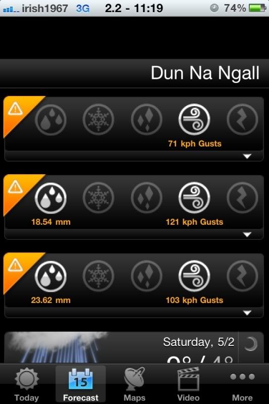
    Accuweather app giving excellent winds for next couple of days

    e24ffad2.jpg


  • Advertisement
  • Registered Users Posts: 2,805 ✭✭✭sparrowcar


    Latest TAF from Dublin airport

    030500Z 0306/0406 24014KT 9999 SCT030 BECMG 0310/0312 20017G30KT BECMG 0312/0314 21024G38KT SCT010 BKN020 TEMPO 0314/0321 23030G48KT TEMPO 0315/0406 5000 RA BKN008 BECMG 0321/0323 25020G32KT TEMPO 0402/0406 25025G42KT=

    Will be an interesting day in work... :rolleyes:


Advertisement