Advertisement
If you have a new account but are having problems posting or verifying your account, please email us on hello@boards.ie for help. Thanks :)
Hello all! Please ensure that you are posting a new thread or question in the appropriate forum. The Feedback forum is overwhelmed with questions that are having to be moved elsewhere. If you need help to verify your account contact hello@boards.ie
Hi all! We have been experiencing an issue on site where threads have been missing the latest postings. The platform host Vanilla are working on this issue. A workaround that has been used by some is to navigate back from 1 to 10+ pages to re-sync the thread and this will then show the latest posts. Thanks, Mike.
Hi there,
There is an issue with role permissions that is being worked on at the moment.
If you are having trouble with access or permissions on regional forums please post here to get access: https://www.boards.ie/discussion/2058365403/you-do-not-have-permission-for-that#latest

Interesting Maps

13031333536162

Comments

  • Registered Users, Registered Users 2 Posts: 8,637 ✭✭✭Gloomtastic!


    Anyone seen any good maps? :rolleyes:


  • Registered Users, Registered Users 2 Posts: 5,178 ✭✭✭killbillvol2


    endainoz wrote: »
    I got to visit China in the summer of 2018 and had the chance to take the bullet train from Shanghai to Beijing. It was a marvel of engineering to be fair, can't quite remember how long the journey was but I checked the speed at one point as can be seen from this low quality photo.

    I did Beijing to Guangzhou a couple of years ago. Over 2400 km in 8 hours. Only 5 stops. Just over €100 for first class.


  • Registered Users, Registered Users 2 Posts: 71,799 ✭✭✭✭Ted_YNWA


    Mod

    Before this thread completely de-rails, can we get back on topic.


  • Registered Users Posts: 4,487 ✭✭✭KevRossi


    Map of the proposed Berlin to Baghdad railway. It took 40 years to build, first train ran in 1940 and was one of the causes of WW1.

    I've no idea how long it took, or its average speed. Sorry.

    berlin-baghdad-bahn-map2.jpg


  • Registered Users, Registered Users 2 Posts: 21,972 ✭✭✭✭Tell me how


    KevRossi wrote: »
    Map of the proposed Berlin to Baghdad railway. It took 40 years to build, first train ran in 1940 and was one of the causes of WW1.

    I've no idea how long it took, or its average speed. Sorry.

    Umm.....What?


  • Registered Users, Registered Users 2 Posts: 8,782 ✭✭✭Quantum Erasure


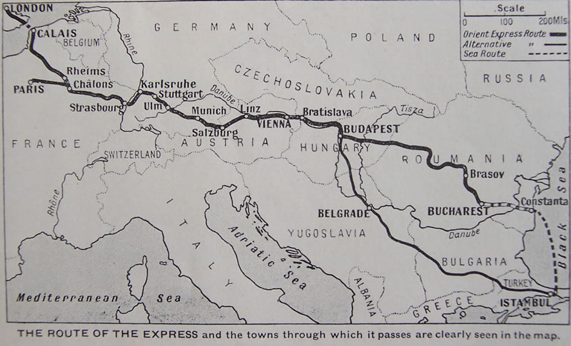
    Route of the Orient Express, originally from Paris to Vienna

    ciwlorientexpressmap3-800.jpg


  • Registered Users, Registered Users 2 Posts: 19,085 ✭✭✭✭BonnieSituation


    Umm.....What?

    It took 40 years to build. So Started ca. 1900 and the building of it was a contributing factor to WWI. So something happened between 1900 and 1914 that helped WWI to move along.


  • Registered Users, Registered Users 2 Posts: 4,807 ✭✭✭ablelocks


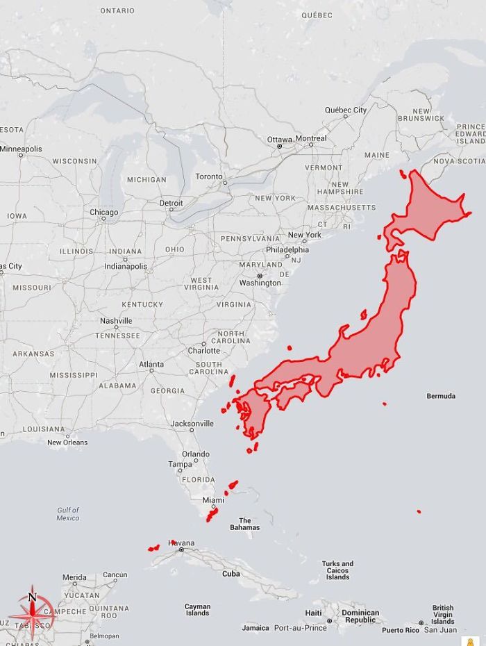
    **** me, Japan is Big!

    5f86c0d2ea7e6_hq4e3b6rtzwz__700.jpg


  • Registered Users, Registered Users 2 Posts: 4,807 ✭✭✭ablelocks


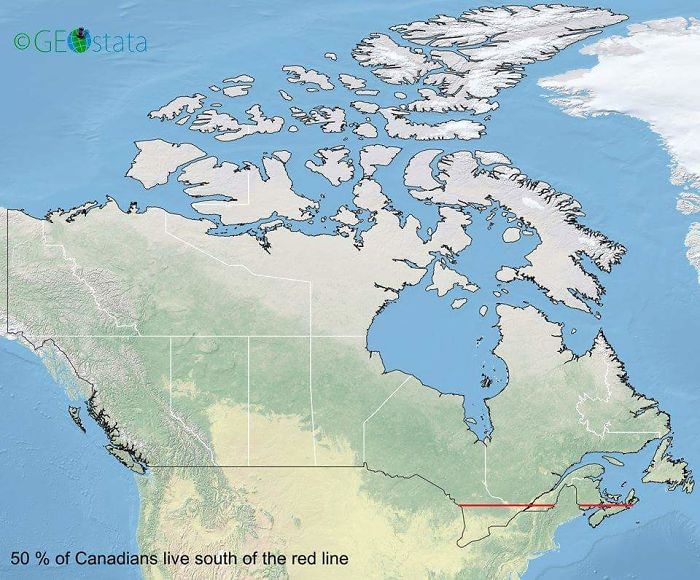
    50% of Canadians live south of the red line

    5f86bf286fe9e_zyuo1lup6gbz__700.jpg


  • Banned (with Prison Access) Posts: 9,078 ✭✭✭IAMAMORON


    KevRossi wrote: »
    Map of the proposed Berlin to Baghdad railway. It took 40 years to build, first train ran in 1940 and was one of the causes of WW1.

    I've no idea how long it took, or its average speed. Sorry.

    berlin-baghdad-bahn-map2.jpg
    Umm.....What?

    Kevo, not trying to be a smartass, but is that a typo or was the route planned prior to 1914 and are you insinuating that it was a cause of international tension prior to the escalation of the war and the assassination of the Archduke Ferdinand?


  • Advertisement
  • Registered Users, Registered Users 2 Posts: 3,888 ✭✭✭chooseusername


    IAMAMORON wrote: »
    Kevo, not trying to be a smartass, but is that a typo or was the route planned prior to 1914 and are you insinuating that it was a cause of international tension prior to the escalation of the war and the assassination of the Archduke Ferdinand?

    https://apps.dtic.mil/dtic/tr/fulltext/u2/a138432.pdf

    Will take a while to load, but interesting.


  • Registered Users, Registered Users 2 Posts: 3,862 ✭✭✭mikhail


    For the curious, the wikipedia page on the Berlin-Baghdad railway does a decent job of explaining it.

    https://en.wikipedia.org/wiki/Berlin–Baghdad_railway

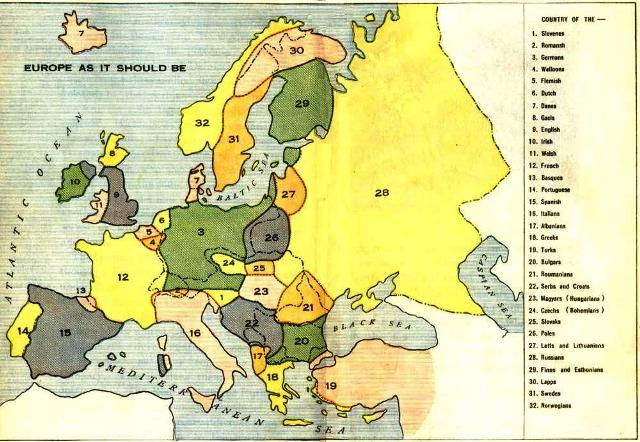
    To keep the maps coming lest the mods step in, here's Louis P. Bénézet's map of "Europe As It Should Be" (1918), depicting imagined nations based on ethnic and linguistic criteria. He basically was trying to solve the kinds of ethnic tensions he blamed as a leading cause of WWI.

    Europe_as_it_should_be_map.jpg

    Wales incorporating SW England is a new one to me. It also gives the Basques their independence, but not the Catalonians. The Ukranians might object too. There's a Yugoslavia of sorts, and we saw how well that turned out. The Greeks get part of the Turkish coast, which would have been quite the war!


  • Moderators, Sports Moderators Posts: 7,265 Mod ✭✭✭✭cdeb


    All that, and you left out the North!


  • Moderators, Science, Health & Environment Moderators, Society & Culture Moderators Posts: 6,309 Mod ✭✭✭✭mzungu


    The 7000 rivers that feed into the Mississippi.


    map-of-rivers-that-feed-into-the-mississippi-river.jpg?w=800&h=445


  • Registered Users, Registered Users 2 Posts: 9,095 ✭✭✭Gregor Samsa


    mikhail wrote: »
    Wales incorporating SW England is a new one to me. It also gives the Basques their independence, but not the Catalonians. The Ukranians might object too. There's a Yugoslavia of sorts, and we saw how well that turned out. The Greeks get part of the Turkish coast, which would have been quite the war!

    Maybe he’s lumping the Welsh and the Cornish in together as some kind of Brythonic unit, but that map does look as if it would start as many wars as it would prevent.


  • Registered Users Posts: 4,487 ✭✭✭KevRossi


    It took 40 years to build. So Started ca. 1900 and the building of it was a contributing factor to WWI. So something happened between 1900 and 1914 that helped WWI to move along.

    They had issues getting through the Taurus mountains, then they had efficteively no money, power or influence for most of the 1920's and early 1930's.
    IAMAMORON wrote: »
    Kevo, not trying to be a smartass, but is that a typo or was the route planned prior to 1914 and are you insinuating that it was a cause of international tension prior to the escalation of the war and the assassination of the Archduke Ferdinand?

    British were worried that a line to Baghdad and on to Basra would give the Germans too much leverage when it came to India. If the Germans controlled that line, they could get from Berlin to Bombay by train and boat quicker than the British from London by sea.

    It would have given them an increasing sphere of influence in the Arabian peninsula (they had plans for lines from Damascus to Aden as well as down the east to Muscat. Thus having full control over the peninsula and possible control over the Red Sea and Arabian Sea.

    It was one of the reasons why they went so hard against them in Versailles. Same situation applied to German colonies in Africa.

    Ironically, if there had been no WW1, the Germans would have been sitting on the oil wells when they were discovered in the 1920's. Instead the US and British got there first and the rest is history.


  • Registered Users, Registered Users 2 Posts: 3,862 ✭✭✭mikhail


    cdeb wrote: »
    All that, and you left out the North!
    I can comprehend the thinking, so I didn't comment. Obviously, it's of local interest.
    Maybe he’s lumping the Welsh and the Cornish in together as some kind of Brythonic unit, but that map does look as if it would start as many wars as it would prevent.
    I guess so, but I can't say I have any sense of there being a Cornish identity as late as that. In 1918, Cornish was already long extinct as a first language.


  • Moderators, Recreation & Hobbies Moderators, Science, Health & Environment Moderators, Technology & Internet Moderators Posts: 92,550 Mod ✭✭✭✭Capt'n Midnight


    KevRossi wrote: »
    Ironically, if there had been no WW1, the Germans would have been sitting on the oil wells when they were discovered in the 1920's. Instead the US and British got there first and the rest is history.
    Italy invaded the Turkish province of Libya in 1911. So a slightly different timeline would have left Turkey with a huge chunk of the world's oil.

    English desire for a secure oil supply lead to a coup in Persia in 1921 and invasion and occupation in 1941 -1946 and another coup in 1953 and then there was the revolution in 1979


    Map_of_the_Achaemenid_Empire.jpg


  • Moderators, Recreation & Hobbies Moderators, Science, Health & Environment Moderators, Technology & Internet Moderators Posts: 92,550 Mod ✭✭✭✭Capt'n Midnight


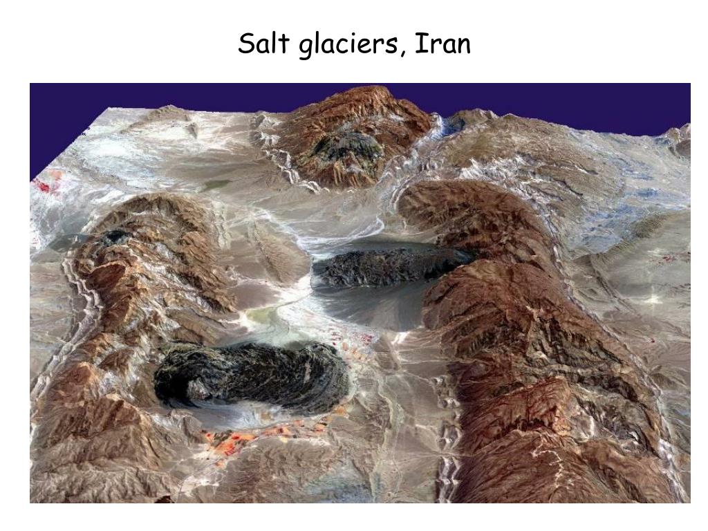
    salt-glaciers-iran-l.jpg


  • Advertisement
  • Moderators, Politics Moderators Posts: 40,346 Mod ✭✭✭✭Seth Brundle


  • Banned (with Prison Access) Posts: 9,078 ✭✭✭IAMAMORON


    Map of Kurdistan. olek4trq8gd51.jpg


  • Registered Users, Registered Users 2 Posts: 8,578 ✭✭✭Markcheese


    mikhail wrote: »
    I can comprehend the thinking, so I didn't comment. Obviously, it's of local interest.


    I guess so, but I can't say I have any sense of there being a Cornish identity as late as that. In 1918, Cornish was already long extinct as a first language.
    I dunno , they see themselves as english ,kind of in the same way as the english or welsh see themselves as british ,
    A rural cornish person going to exeter for the day would still tell you that he's going to england ..

    Slava ukraini 🇺🇦


  • Registered Users Posts: 4,487 ✭✭✭KevRossi


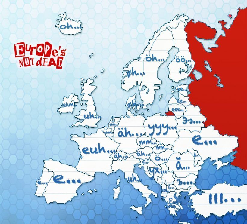
    Emmmm.... this is a ehhhh... map of errrrrr...... filler words ummm..... used in ahhhh.... different uuuhhh..... countries.

    EkmY868XUAAyTes?format=jpg&name=900x900


  • Registered Users, Registered Users 2 Posts: 20,111 ✭✭✭✭cnocbui


    You could replace that map with this one, making things a lot simpler:

    Australian-mines-map.jpg


  • Registered Users, Registered Users 2 Posts: 24,467 ✭✭✭✭lawred2


    It's like they had one page and went from left to right but ran out of room for the North..


  • Advertisement
  • Moderators, Social & Fun Moderators Posts: 12,899 Mod ✭✭✭✭JupiterKid


    Map of the Harz Mountains region of North Central Germany.

    Until the fall of the Iron Curtain these mountains straddled the militarized frontier of West versus East.


    11417_elu0j011q0jflrnj.png


  • Banned (with Prison Access) Posts: 386 ✭✭Biafranlivemat


    This is who mines the cobalt.
    2014611145555381893_8-e1489321737583.jpg

    "This report documents the hazardous conditions in which artisanal miners, including thousands of children, mine cobalt in the Democratic Republic of the Congo. It goes on to trace how this cobalt is used to power mobile phones, laptop computers, and other portable electronic devices. Using basic hand tools, miners dig out rocks from tunnels deep underground, and accidents are common. Despite the potentially fatal health effects of prolonged exposure to cobalt, adult and child miners work without even the most basic protective equipment"

    https://www.amnesty.org/en/documents/afr62/3183/2016/en/


  • Registered Users, Registered Users 2 Posts: 8,782 ✭✭✭Quantum Erasure


    Screenshot-2020-07-29-at-14.10.02.png


  • Registered Users, Registered Users 2 Posts: 25,420 ✭✭✭✭sligojoek


    Screenshot-2020-07-29-at-14.10.02.png

    They don't seem too bothered about it in Africa.


  • Registered Users, Registered Users 2 Posts: 5,912 ✭✭✭Charles Babbage


    retalivity wrote: »
    For Donegal/Tyrconnell, Arranmore and Tory were not planted, in fact there wasnt much land planted west of Letterkenny, thats where all the Irish that remained after the flight of the earls were dispossessed to. Land is/was way too boggy and poor for the planters, so they never bothered with it. Similar story with Mid-derry/tyrone, and the glens of Antrim.
    Hence why it is also, still one of the strongest gaeltachts in the country (Donegal), and there is a strong Gael presence in the other areas as well.


    Linguistic setup in Ulster in 1800.


    dz71jgnzjgt51.jpg


  • Advertisement
  • Registered Users Posts: 441 ✭✭forgottenhills


    Linguistic setup in Ulster in 1800.


    dz71jgnzjgt51.jpg

    Why have they left out half of Cavan on that interesting map of Ulster? Do you have a link to the original (non Reddit) source of this map?

    CaLM - Cavan language matters...

    Also that inset map shows the Yola language area of the SE tip of Wexford, a language now largely overlooked by mainstream history.


  • Banned (with Prison Access) Posts: 9,078 ✭✭✭IAMAMORON


    Up Virginia, Bally Duff and Lavey.

    Come on Cavan.


  • Banned (with Prison Access) Posts: 9,078 ✭✭✭IAMAMORON


    For the record I doubt there were any phuckers speaking Irish outside of Donegal before 1850. Just saying.

    I am looking forward to some Tyronian and Armaghanian outrage now, but they know it's true. Even the druids up the Sperrins and in Carraig Mhor are speaking English the last few hundred years. Heathens.


  • Registered Users, Registered Users 2 Posts: 14,381 ✭✭✭✭Professor Moriarty


    Ulster Scots is a language? Hmmm. Let's see...

    Dae A need a new aerial?
    Gin ye hae guid analogue reception the nou, ye'r like no tae need tae replace yer ruiftap or set-tap aerial for the cheenge-ower – thare nae sic thing as a 'deegital aerial'. But gin ye hae ill analogue reception the nou, ye’ll mebbe need tae replace it.
    Find oot by gaun til the aerial-pruifer on Teletext page 284. Anither wey is tae wait until efter the cheenge-ower for tae see if yer pictur's affect.


    Doesn't compute.


  • Registered Users, Registered Users 2 Posts: 19,085 ✭✭✭✭BonnieSituation


    The Ulster Scots Agency was only thrown into the GFA as a sop to belligerent Unionists who thought that giving Irish recognition was a concession for Nationalists.

    I think the recognition of dialects and lingual difference is very important, however this was nonsense.


  • Registered Users, Registered Users 2 Posts: 5,912 ✭✭✭Charles Babbage


    Why have they left out half of Cavan on that interesting map of Ulster? Do you have a link to the original (non Reddit) source of this map?


    Sorry, I just saw it on Reddit.


    IAMAMORON wrote:
    For the record I doubt there were any phuckers speaking Irish outside of Donegal before 1850. Just saying.


    I think people spoke Irish in many places before 1850, it was after that they the areas away from the western seaboard were squeezed.


  • Moderators, Politics Moderators Posts: 40,346 Mod ✭✭✭✭Seth Brundle


    Homo sapiens population density
    63wq41quopt51.png


  • Moderators, Politics Moderators Posts: 40,346 Mod ✭✭✭✭Seth Brundle


  • Moderators, Politics Moderators Posts: 40,346 Mod ✭✭✭✭Seth Brundle


  • Registered Users, Registered Users 2 Posts: 20,111 ✭✭✭✭cnocbui


    Homo sapiens population density

    Covid-19 is taking note and says thank you.


  • Advertisement
  • Registered Users, Registered Users 2 Posts: 8,782 ✭✭✭Quantum Erasure


    (found on Reddit)
    In 1973, 40 nodes connected 45 computers. This was the entire internet at the time. This chart was found in 2016 amongst some old papers

    camfpeag2au51.jpg


  • Registered Users, Registered Users 2 Posts: 71,799 ✭✭✭✭Ted_YNWA


    Back then they had Imps, now we have Trolls.


  • Closed Accounts Posts: 154 ✭✭Nexytus


  • Registered Users, Registered Users 2 Posts: 8,578 ✭✭✭Markcheese


    Nexytus wrote: »

    Ok that surprised me ... In my head it was about the length of Britain .... And I pretty much did the length of NZ ,( not in one go though )

    Slava ukraini 🇺🇦


  • Registered Users, Registered Users 2 Posts: 927 ✭✭✭Icaras


    Its not even the same size as New Zealand!


  • Closed Accounts Posts: 4,950 ✭✭✭ChikiChiki


    Nexytus wrote: »

    That has me confused as fook.


  • Registered Users, Registered Users 2 Posts: 19,085 ✭✭✭✭BonnieSituation


    Icaras wrote: »
    Its not even the same size as New Zealand!

    That's just a case of the data frame of the image underneath being slightly different to the one being used by True Size.

    If you rotate it slightly clockwise in your head you'll see it line up better.


    Not sure what True Size uses and I'm on mobile so not able to properly check, but Google Maps (in)famously uses a WGS84-based projection called Web Mercator.

    https://en.wikipedia.org/wiki/Mercator_projection

    True Size probably uses the same but there's a slight rotation in the data frame somewhere giving that effect.


  • Registered Users, Registered Users 2 Posts: 20,111 ✭✭✭✭cnocbui


    (found on Reddit)
    In 1973, 40 nodes connected 45 computers. This was the entire internet at the time. This chart was found in 2016 amongst some old papers

    Seeing the PDP references on that map brought back memories. A university library I worked in briefly in the mid 80's, had a small dedicated room to house a DEC PDP-11/40 mainframe computer to handle the library catalogue and the book lending system. One day there was a technician pulling it apart and apparently there had been a rare head crash involving one of the swapable disc packs which contained multiple hard disc platters. The drive the pack mounted to was about the size of a washing machine and a pack of multiple large discs only a storage capacity of a few tens of megabytes.

    The tech kindly let me souvenier one of the disks from the damaged pack, which you can see here:

    Hard-Disk-PDP11-40.jpg

    This disc probably only held about a megabyte. The relatively tiny Micro SD card I have balanced on top of it could hold 1 TB. The mind boggles at how far things have come.


  • Registered Users, Registered Users 2 Posts: 10,301 ✭✭✭✭gerrybbadd


    I love the true size of. It's great to take Vatican City and move it around various places. It's actually smaller than the relatively small estate i'm living in!


  • Advertisement
  • Registered Users Posts: 1,614 ✭✭✭WrenBoy


    Homo sapiens population density
    63wq41quopt51.png
    cnocbui wrote: »
    Covid-19 is taking note and says thank you.

    Way to go Seth, ya doingus !


Advertisement