Advertisement
If you have a new account but are having problems posting or verifying your account, please email us on hello@boards.ie for help. Thanks :)
Hello all! Please ensure that you are posting a new thread or question in the appropriate forum. The Feedback forum is overwhelmed with questions that are having to be moved elsewhere. If you need help to verify your account contact hello@boards.ie

Seen & Found

Options
12627283032

Comments

  • Registered Users Posts: 6,211 ✭✭✭The Continental Op


    If its smaller than a towing eye then how about a folding hoof pick - new example https://www.amazon.co.uk/Shires-Equestrian-Folding-Silver-Onesize/dp/B007WMB404/

    Wake me up when it's all over.


  • Moderators, Category Moderators, Arts Moderators, Sports Moderators Posts: 48,331 CMod ✭✭✭✭magicbastarder


    not sure if this thread is intended for items you've found yourself, or items found by others too;

    Spotted by drone: an ancient logboat in the river Boyne at Drogheda
    https://mythicalireland.com/MI/blog/news/spotted-by-drone-an-ancient-logboat-in-the-river-boyne-at-drogheda/


  • Registered Users Posts: 6,211 ✭✭✭The Continental Op


    not sure if this thread is intended for items you've found yourself, or items found by others too;

    Spotted by drone: an ancient logboat in the river Boyne at Drogheda
    https://mythicalireland.com/MI/blog/news/spotted-by-drone-an-ancient-logboat-in-the-river-boyne-at-drogheda/

    Looks like a very warped plank to me? Love it to be a logboat but nothing like what I'd imagine one to be.

    Wake me up when it's all over.


  • Moderators, Category Moderators, Arts Moderators, Sports Moderators Posts: 48,331 CMod ✭✭✭✭magicbastarder


  • Registered Users Posts: 6,211 ✭✭✭The Continental Op


    Yes but a much thicker plank. Just how thin could you burn and carve out a log boat?

    Wake me up when it's all over.


  • Advertisement
  • Moderators, Science, Health & Environment Moderators Posts: 5,218 Mod ✭✭✭✭slowburner


    Yes but a much thicker plank. Just how thin could you burn and carve out a log boat?
    The thin walls are more likely to have been worn down by erosive processes over a prolonged period rather than a result of the original construction. Great find


  • Registered Users Posts: 6,211 ✭✭✭The Continental Op


    slowburner wrote: »
    The thin walls are more likely to have been worn down by erosive processes over a prolonged period rather than a result of the original construction. Great find

    As I said I'd be happy if the guy has found a logboat but really thin dead straight edges aren't something that turn up to often in archaeology.

    Wake me up when it's all over.


  • Moderators, Science, Health & Environment Moderators Posts: 5,218 Mod ✭✭✭✭slowburner


    As I said I'd be happy if the guy has found a logboat but really thin dead straight edges aren't something that turn up to often in archaeology.

    Both Geraldine Stout and Níall Gregory are of the opinion that it’s a log boat - according to the finder. Niall Gregory is the authority on the subject in Ireland and Geraldine Stout needs no introduction here.
    But I guess nobody will know for certain until it’s fully investigated.


  • Registered Users Posts: 441 ✭✭forgottenhills


    Looks like a very warped plank to me? Love it to be a logboat but nothing like what I'd imagine one to be.

    Well to my amateur eye it looks nothing like a plank, in fact it looks too much like a boat to be a really old one if I had to guess. The other interesting thing is how low the river looks there, and I know its the tidal bit. The Boyne you normally see is a pretty big river.


  • Moderators, Category Moderators, Arts Moderators, Sports Moderators Posts: 48,331 CMod ✭✭✭✭magicbastarder


    from the article:
    "The river level at low tide is particularly low following a prolonged period in which there has been little or no rain."


  • Advertisement
  • Registered Users Posts: 441 ✭✭forgottenhills


    from the article:
    "The river level at low tide is particularly low following a prolonged period in which there has been little or no rain."

    I read that but even so it looks remarkably low in those photos. There is water slowly released into the Boyne from Cavan rivers and bogs via Lough Ramor and the Blackwater which should smooth out the rainfall supply a bit. Is there some siphoning off the water of the Boyne happening via irrigation or other use?

    Edit: to answer my own question there is considerable siphoning off the Boyne in schemes such as the following googled link:
    https://www.irishtimes.com/news/ireland/irish-news/what-happened-to-the-water-supply-in-the-northeast-1.3165035


  • Registered Users Posts: 262 ✭✭tromtipp


    Very interesting - looks like a classic dugout log boat, but seems to have something in it - or is that random detritis that snagged on it?


  • Registered Users Posts: 441 ✭✭forgottenhills


    tromtipp wrote: »
    Very interesting - looks like a classic dugout log boat, but seems to have something in it - or is that random detritis that snagged on it?

    Looks to me like a piece of tarp that is snagged on the big hole in the old boat.

    There have been many small Irish rivers dredged over the years to improve drainage. I'd imagine that the big diggers used for this have thrown up and smashed many's the old boat sitting in mud at the bottom of these rivers.


  • Registered Users Posts: 6,211 ✭✭✭The Continental Op


    Looks to me like a piece of tarp that is snagged on the big hole in the old boat.

    There have been many small Irish rivers dredged over the years to improve drainage. I'd imagine that the big diggers used for this have thrown up and smashed many's the old boat sitting in mud at the bottom of these rivers.

    Its about the proportions of a 40kg polypropylene coal sack?

    Wake me up when it's all over.


  • Registered Users Posts: 441 ✭✭forgottenhills


    Its about the proportions of a 40kg polypropylene coal sack?

    You could be right, although I thought I saw a what looked like an edge on it in one of the photos which suggested a bit of tarp or heavy plastic sheeting to me. Anyway I think we can agree that its not part of the original boat!


  • Registered Users Posts: 6,211 ✭✭✭The Continental Op


    You could be right, although I thought I saw a what looked like an edge on it in one of the photos which suggested a bit of tarp or heavy plastic sheeting to me. Anyway I think we can agree that its not part of the original boat!

    Not a sail then :D

    Wake me up when it's all over.


  • Registered Users Posts: 135 ✭✭mocmo


    As I said I'd be happy if the guy has found a logboat but really thin dead straight edges aren't something that turn up to often in archaeology.

    I disagree archaeological timber is often very well finished with dead straight, regular edges. I've worked on a number of logboats and this is actually fairly typical of what they look like with the sides heavily eroded/damaged and/or missing. I'd be fairly confident that this is one, but as is pointed out in the thread Dr Niall Gregory is the expert and if he has given the thumbs up it's a log boat!


  • Moderators, Science, Health & Environment Moderators Posts: 5,218 Mod ✭✭✭✭slowburner


    It seems the finder has had to row back on his claim (sorry)
    This logboat was already known to the NMS. It was identified last year. I would imagine that tidal conditions and Covid restrictions made it difficult to achieve anything in terms of recording and conservation but Dr. Gregory recently visited the site and has recorded both boats. The second one may be a later craft.


  • Registered Users Posts: 127 ✭✭HoteiMarkii


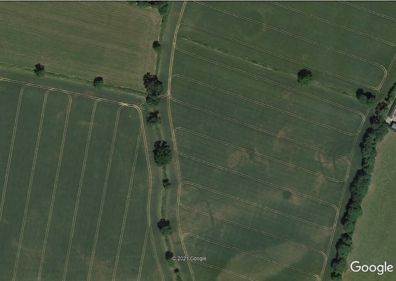
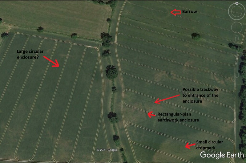
    I found these interesting looking cropmarks on Google Earth this evening. They haven't been recorded on the Sites and Monuments Record database:

    51155464422_24917abdce_c.jpg

    51156142421_50bc5b5ceb_c.jpg

    There's a very clear rectangular shaped enclosure with an entrance to the east-northeast, and what may be a track or roadway leading from it to some other curious shaped cropmarks. 200 metres north of the rectangular enclosure is a circular feature which is likely to be a barrow (with an approximate diameter of 38 metres). A smaller circular cropmark is visible 70 metres southeast of the rectangular enclosure. A faint cropmark of a very large circular enclosure (approx. 60 metres in diameter) is visible 70 metres northeast of the rectangular enclosure.

    Rectangular enclosure:

    51156153406_3d42a10f8b_c.jpg

    51156392258_7f1e015537_c.jpg

    Ring-barrow:

    51156896064_b26ecf8f22_c.jpg

    These cropmarks lie in tillage just southwest of Pollardstown fen, Co.Kildare. They only appear on current Google Earth satellite imagery. There may be another large circular enclosure just northeast of the possible barrow (in the top right hand corner of the field boundary). If anyone wants to take a closer look, you'll find the rectangular enclosure at:

    53°10' 59.01" N 6° 52' 06.97 W

    Latitude:53.182938
    Longitude: -6.8687596

    ITM Co-ordinates
    X: 675611
    Y: 715317

    The rectangular enclosure may be medieval in date and could be a farmstead, perhaps? The circular features may be prehistoric.


  • Moderators, Category Moderators, Arts Moderators, Sports Moderators Posts: 48,331 CMod ✭✭✭✭magicbastarder


    are there any online resources to help rule out what may be crop marks from modern agriculture?
    e.g. there are some marks in this field, but i don't know how to distinguish what may be due to modern agriculture.

    https://www.google.com/maps/@53.5995786,-6.2783264,483m/data=!3m1!1e3


  • Advertisement
  • Registered Users Posts: 135 ✭✭mocmo


    Have you checked it out on archaeology.ie, it looks like there are a fair few known monuments in it.


  • Moderators, Category Moderators, Arts Moderators, Sports Moderators Posts: 48,331 CMod ✭✭✭✭magicbastarder


    cheers, i hadn't - but i'm curious as to whether if i do find something which is visible on satellite, but not marked on the archaeology viewer, whether there are any easy or rough guidelines to point to the antiquity of them?
    i kinda just picked that field at random.


  • Moderators, Science, Health & Environment Moderators Posts: 5,218 Mod ✭✭✭✭slowburner


    cheers, i hadn't - but i'm curious as to whether if i do find something which is visible on satellite, but not marked on the archaeology viewer, whether there are any easy or rough guidelines to point to the antiquity of them?
    i kinda just picked that field at random.

    I waited a while to see if anyone else wanted to offer help on this subject.

    There is a wealth of online resources to check the 'antiquity' of features.
    The first port of call is undoubtedly the Historic Environment Viewer provided by the National Monuments Service. This is an online resource cataloguing all monuments known to date from before 1700 AD.* It is the online version of the Sites and Monuments Record (SMR) and is maintained by the Archaeological Survey of Ireland (ASI) with 'new' sites added as they are reported.

    The records from the SMR are replicated on two other sites:
    http://map.geohive.ie/mapviewer.html
    and,
    https://heritagemaps.ie/WebApps/HeritageMaps/index.html

    Both of these sites have the considerable advantage that it is possible to work backwards from the potential discovery of a feature through aerial imagery. In other words: if you think you may have found something interesting, it is important to check if it persists in earlier aerial imagery. If it does, then it is more likely to be something of substance rather than an illusion.
    The ASI webviewer is limited to recent aerials and historic mapping. Geohive and Heritage Maps include imagery from 1995 (B/W), 2000, 2005 and more up to date imagery as well as the Historic Maps. These layers can be switched on as necessary and their transparency adjusted which can be very useful.

    Then there are a number of satellite imagery resources like Google Earth, Bing Maps and others.
    The time slider on Google Earth is a really useful tool. If a potential feature appears on the current imagery, it's always a good idea to slide back in time and see if the feature persists. There are a number of other processes that can create features that appear to be something from antiquity, especially if your eye is tuned in to circular features. Agriculture is probably the primary source but nature can throw up some convincing shapes too in the form of 'fairy rings' created by fungal growth and other quirky formations. Drains in fields can often form puzzling arrangements and create the impression of something from antiquity. Often too, earlier field fences/boundaries were removed to create more open fields and sometimes the isolated remains create a false impression. It is crucial to always compare up to date imagery with the historic maps. Another aspect of agriculture that can easily deceive is animal feeders. They can often look extremely like barrows.

    nJnWJ6g.png

    It's not easy to distill down a whole aspect of archaeology into a single post but I hope that this has given you some pointers. It's really all about becoming familiar with the resources and getting an eye for the right things.

    One last thing to remember is that genuine cropmarks that indicate the presence of something archaeological vary in how they were formed. There are 'positive and negative' cropmarks. These are formed by either building something up or digging down. Positive cropmarks tend to be lighter in colour because the dry more rapidly and do not retain moisture - they indicate the presence of something that was above original ground level and possibly a higher concentration of stone. Darker cropmarks indicate the existence of something below original ground level that retains moisture - usually something like a ditch.
    Or you might find something like this as yet unrecorded feature which has both positive and negative cropmarks. The positive cropmarks have been ploughed out and distributed but the surrounding ring ditch survives well.

    yKBauys.png

    Archaeologists always undertake an intensive desktop survey in advance of any excavation and these resources form the backbone of that survey; along with documentary evidence and analysis of previous excavations. It really is a whole set of skills unique to the profession but the contribution of non-professionals in recent years has been outstanding.


    * There is some confusion about the so-called post-1700 AD cut off point. This cut-off applies only to the schedule of listings on the ASI. It does not imply that anything dating to after 1700 AD is not archaeological and does not imply that anything from after 1700 AD is not afforded the same protection as anything dating from 1700 BC. All archaeological objects have the same level of protection no matter when they date from.


  • Moderators, Category Moderators, Arts Moderators, Sports Moderators Posts: 48,331 CMod ✭✭✭✭magicbastarder


    cheers - much appreciated.

    one thing i was wary of, and i don't even know if the effect of it would last long in the soil, would be circular feeders a farmer would drop in a field for feeding cattle; but i suspect these would be uniformly small (only 2 or 3m across)?


  • Moderators, Science, Health & Environment Moderators Posts: 5,218 Mod ✭✭✭✭slowburner


    cheers - much appreciated.

    one thing i was wary of, and i don't even know if the effect of it would last long in the soil, would be circular feeders a farmer would drop in a field for feeding cattle; but i suspect these would be uniformly small (only 2 or 3m across)?
    Check out the first photo in the post above. The rings are from cattle feeders.
    If rings like this are close to farm buildings, then there is a greater chance they are the result of animal feeders


  • Moderators, Category Moderators, Arts Moderators, Sports Moderators Posts: 48,331 CMod ✭✭✭✭magicbastarder


    whoops! i missed that line, apologies.


  • Moderators, Category Moderators, Arts Moderators, Sports Moderators Posts: 48,331 CMod ✭✭✭✭magicbastarder


    slowburner wrote: »
    It seems the finder has had to row back on his claim (sorry)
    This logboat was already known to the NMS. It was identified last year. I would imagine that tidal conditions and Covid restrictions made it difficult to achieve anything in terms of recording and conservation but Dr. Gregory recently visited the site and has recorded both boats. The second one may be a later craft.
    This story still has legs seemingly. The one which had been previously known about was one of three he found - the two others are new, and seemingly in close proximity. Perhaps there was initial confusion as they may have confused the initial 'new' one with the one previously known?

    https://www.rte.ie/news/leinster/2021/0510/1220791-logboats-louth/


  • Registered Users Posts: 262 ✭✭tromtipp


    Is that a fish trap underneath it? That would be more exciting than the boat!


  • Moderators, Category Moderators, Arts Moderators, Sports Moderators Posts: 48,331 CMod ✭✭✭✭magicbastarder


    more info here:

    The logboats of the river Boyne in Drogheda - an expert assessment
    https://mythicalireland.com/MI/blog/news/the-logboats-of-the-river-boyne-in-drogheda-an-expert-assessment/


  • Advertisement
  • Registered Users Posts: 3,119 ✭✭✭Ms2011


    Ms2011 wrote: »
    Any idea if this is a reproduction?
    Found in the shed of our new (200 year old) house.

    Attachment not found.

    Just thought I'd update this.
    The heads appear to be "One of two granite corbels for mantle shelf, showing portraits of man and woman. Apparently taken from Ballymoon (castle). Dress details suggest thirteenth-century date"

    Information found on Archaeology.ie complied by Claire Breen on 11th January 2012.


Advertisement