Advertisement
If you have a new account but are having problems posting or verifying your account, please email us on hello@boards.ie for help. Thanks :)
Hello all! Please ensure that you are posting a new thread or question in the appropriate forum. The Feedback forum is overwhelmed with questions that are having to be moved elsewhere. If you need help to verify your account contact hello@boards.ie
Hi all! We have been experiencing an issue on site where threads have been missing the latest postings. The platform host Vanilla are working on this issue. A workaround that has been used by some is to navigate back from 1 to 10+ pages to re-sync the thread and this will then show the latest posts. Thanks, Mike.
Hi there,
There is an issue with role permissions that is being worked on at the moment.
If you are having trouble with access or permissions on regional forums please post here to get access: https://www.boards.ie/discussion/2058365403/you-do-not-have-permission-for-that#latest

Interesting Maps

17980828485162

Comments

  • Moderators, Politics Moderators Posts: 40,327 Mod ✭✭✭✭Seth Brundle


  • Moderators, Politics Moderators Posts: 40,327 Mod ✭✭✭✭Seth Brundle


    _-_


  • Registered Users, Registered Users 2 Posts: 14,164 ✭✭✭✭josip


    I've seen the eagle one before, but never the wolf one. That's amazing, thanks.


  • Posts: 0 [Deleted User]


    Is the White wolf trying to draw a picture of itself? 😮


  • Registered Users, Registered Users 2 Posts: 13,946 ✭✭✭✭Zebra3


  • Advertisement
  • Moderators, Politics Moderators Posts: 40,327 Mod ✭✭✭✭Seth Brundle


    ..


  • Moderators, Social & Fun Moderators Posts: 12,897 Mod ✭✭✭✭JupiterKid


    Map of the age of buildings in Paris, 2016


    You can clearly see that the major reconstruction of Paris in the mid to late 19th Century under Baron Hausmann has left its mark on the urban fabric of Paris as so few buildings predate 1800.

    Much more recent building is evident in the Eastern third of the city (much of it urban renewal) and also towards the edge of the city near the Boulevard Periphique ring motorway that marks the limit of the city of Paris.

    Post edited by JupiterKid on


  • Moderators, Recreation & Hobbies Moderators Posts: 11,655 Mod ✭✭✭✭igCorcaigh


    :)


  • Registered Users, Registered Users 2 Posts: 2,801 ✭✭✭Bogwoppit


    I know a few of these places quite well, I lived in both Pity Me and Nether Wallop. Rest and Be Thankful is in the wrong location, it’s at the end of what used to be a pretty hairy drive over a high pass.

    I also had a road address of Upper Backway in another place I lived in England.

    I have cousins in Puddletown, close to Piddletrenthide

    They’ve left out a place I’ve visited many times, Twatt on the Orkney isles.


  • Moderators, Recreation & Hobbies Moderators, Science, Health & Environment Moderators, Technology & Internet Moderators Posts: 92,544 Mod ✭✭✭✭Capt'n Midnight


    If there was a tunnel from Ireland to the Mull of Kintyre this would be the bottleneck.


  • Advertisement
  • Registered Users, Registered Users 2 Posts: 2,801 ✭✭✭Bogwoppit


    I have been caught out by that more than once. It regularly gets closed off by snowfall too.

    There is an older road through the same pass that they sometimes use when doing maintenance or clearing rockfall but it’s single track and has to be done in convoy.


  • Posts: 0 [Deleted User]


    I've been to Mumbles, but I've never been to Meath.


  • Registered Users, Registered Users 2 Posts: 2,984 ✭✭✭Stovepipe


    Venezuela's oil industry infrastructure was also chronically undermaintained, as even pre-Chavez, it was notorious for the lax attitude to safety from the locals. I worked for a company that was a subsidiary of an American turbine company, that had turbines on site there and everyone hated being detailed to go to Venezuela because of rampant corruption, theft, very slack attitude to safety and general contemptuous attitude from the locals. Shell weren't much better to deal with. I was lucky not to be posted there for a rotation on a rig but several friends were and universally hated the place.


  • Moderators, Social & Fun Moderators Posts: 12,897 Mod ✭✭✭✭JupiterKid


    Video time lapse map of the urban growth of Tokyo between 1800 and 2000.


  • Moderators, Social & Fun Moderators Posts: 12,897 Mod ✭✭✭✭JupiterKid


    Another video time lapse urban growth map - this time of Sydney, Australia between 1800 and 2000.


  • Moderators, Social & Fun Moderators Posts: 12,897 Mod ✭✭✭✭JupiterKid


    And another video time-lapse map of the urban growth of London between 1800 and 2000.


  • Registered Users Posts: 4,487 ✭✭✭KevRossi


    A rough map of old French languages/cultural areas.


  • Registered Users Posts: 4,487 ✭✭✭KevRossi


    Which European language am I reading?

    You can buy a framable poster-size version of the chart here:

    https://ebay.com/itm/373734803960…

    Profits go to The Foundation for Endangered Languages https://ogmios.org


  • Posts: 0 [Deleted User]


    As a guide to answering the question at the top of it, it really doesn't work very well


  • Moderators, Sports Moderators Posts: 7,265 Mod ✭✭✭✭cdeb


    To find Irish, you have to answer "Yes" to "Does it have a "b, G, R or v?"


    It's a lot of languages though; think it's a decent effort overall.


  • Advertisement
  • Registered Users, Registered Users 2 Posts: 2,446 ✭✭✭Hoop66


  • Registered Users, Registered Users 2 Posts: 8,773 ✭✭✭Quantum Erasure


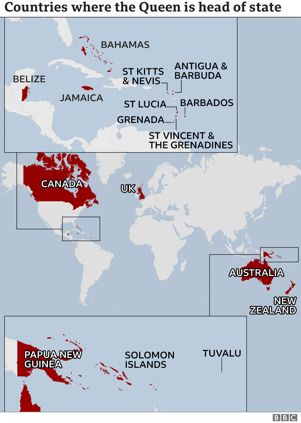
    This is from last year before Barbados became a republic


  • Registered Users Posts: 4,487 ✭✭✭KevRossi


    British Empire on February 6th 1952 and on September 8th 2022. Coronation and death of QE2.


  • Posts: 0 [Deleted User]


    What’s the status change from 1952 for Canada and Australia?


  • Moderators, Category Moderators, Arts Moderators, Sports Moderators Posts: 50,223 CMod ✭✭✭✭magicbastarder


    "This act formally severed all legal ties between Australia and the United Kingdom except for the monarchy."

    "The Canada Act 1982 was passed by the Parliament of the United Kingdom in response to the request from the Canadian Senate and House of Commons to end Britain's authority and transfer the authority for amending the Constitution of Canada to the federal and provincial governments."


  • Posts: 0 [Deleted User]


    I suspect the latter map will soon need significant reworking in light of recent events. Seems it had been put off out of respect for QEII.


  • Registered Users, Registered Users 2 Posts: 3,178 ✭✭✭Brief_Lives


    so much over the top stuff in britain about an aging monarch that died peacefully in her sleep... thats not the case in other parts of Europe...


  • Moderators, Arts Moderators, Recreation & Hobbies Moderators, Social & Fun Moderators Posts: 77,028 Mod ✭✭✭✭New Home


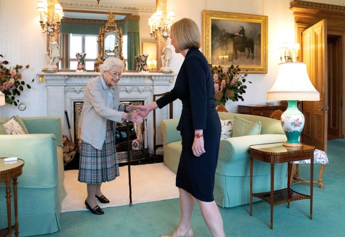
    TBH, I don't think she died peacefully in her sleep, she was in a bad state beforehand. When she met Liz Truss she looked like a hatchling, all bones in a cardigan struggling to stay standing, she was hanging on to her stick for dear life. Plus, if you look at the bruise on her hand that's "leaking" towards her fingers, that's what you get when your veins break when they try to put an IV drip in. I can't say I loved her or hated her, but credit where credit is due, hats off to her for getting up and summoning the strength to carry out official engagements at her age and in that state of health.


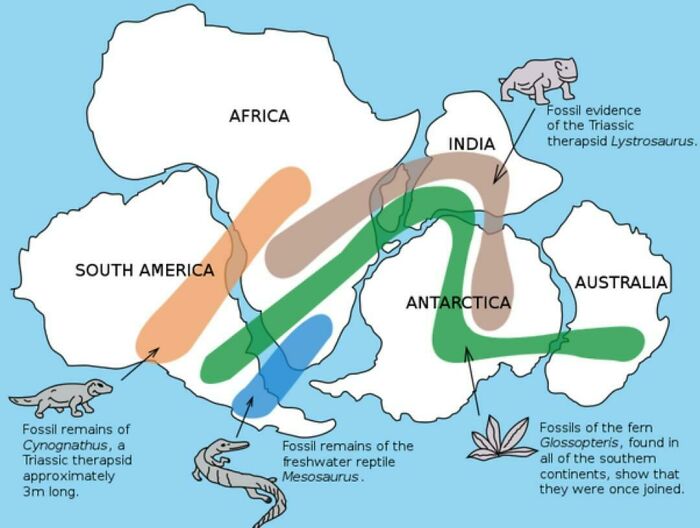
    Anyway, talking about ancient stuff, this maps shows that the existence of Pangaea (birth place of Montgomery C. Burns) can be proven as similar fossils can be found across different continents.


  • Registered Users, Registered Users 2 Posts: 14,587 ✭✭✭✭cj maxx


    A map of places invaded by British under queen Victoria


  • Advertisement
  • Registered Users, Registered Users 2 Posts: 40,530 ✭✭✭✭ohnonotgmail


    You have to explain that map to me. Are the red countries the ones invaded or the green ones? TBH neither makes sense. Australia was a colony before Victoria came to the throne. India also doesnt make sense. It became a british colony in 1857 but there was no invasion. Control simply passed to britain from the British east india company. If it is the green countries that makes less sense.


  • Registered Users, Registered Users 2 Posts: 14,587 ✭✭✭✭cj maxx


    I just assumed it is the red countries. I just googled it.


  • Registered Users, Registered Users 2 Posts: 40,530 ✭✭✭✭ohnonotgmail


    I can't see how it makes any sense to include india or Australia. Or Canada for that matter.


  • Registered Users, Registered Users 2 Posts: 14,587 ✭✭✭✭cj maxx


    Read This

    What is the Commonwealth, which countries is King Charles III head of state for - what role will he play?

    Prince Charles was named king after his mother Queen Elizabeth II passed away at the age of 96 on Thursday.

    By Ethan Evans

    Friday, 9th September 2022, 4:59 pm


    Her Majesty Queen Elizabeth II died at her Balmoral Castle residence in Scotland on Thursday, leading to Prince Charles being named king.

    King Charles III’s wife, the Duchess of Cornwall Camilla Parker Bowles, has also been named as the Queen Consort.

    The nation’s longest-reigning monarch passed away at the age of 96 alongside close family.


    It was confirmed following a statement issued by Buckingham Palace, which read: “The Queen died peacefully at Balmoral this afternoon. The King and the Queen Consort will remain at Balmoral this evening before returning to London tomorrow (Friday).”


    With King Charles III the new head of state for the United Kingdom, this also means that he is in power over 14 countries that are included the Commonwealth - but which ones?

    Here is everything you need to know.


    What is the Commonwealth?


    data:image/svg+xml;base64,PHN2ZyBoZWlnaHQ9IjY3NiIgd2lkdGg9IjEwMjQiIHhtbG5zPSJodHRwOi8vd3d3LnczLm9yZy8yMDAwL3N2ZyIgdmVyc2lvbj0iMS4xIi8+ There was an error displaying this embed.


    His Majesty, King Charles III


    The Commonwealth, which has been a part of international relations for over 100 years, is an association of 54 different countries and territories.

    First established in 1887, the organisation allows each member to work towards shared goals of prosperity, democracy and peace.

    It was agreed in a conference in 1926 that they would all be equal members of a community within the British Empire, pledging allegiance to the King or Queen.

    This does not mean that the United Kingdom rules over any participating Commonwealth countries.


    The purpose of the Commonwealth involves the coordination of the following:

    • Protecting the environment
    • Develop society and young people
    • Supporting democracy
    • Boosting trade links
    • Support small states

    Which countries are a part of the Commonwealth?

    The 54 nations and territories of the Commonwealth come from each corner of the globe .


    The Maldives is the latest nation to rejoin in 2022 after initially leaving the Commonwealth in 2016.

    Here is a full list of all the Commonwealth countries:

    • Antigua and Barbuda
    • Australia
    • Bahamas
    • Bangladesh
    • Barbados
    • Belize
    • Botswana
    • Brunei Darussalam
    • Cameroon
    • Canada
    • Cyprus
    • Dominica
    • eSwatini
    • Fiji
    • Gambia
    • Ghana
    • Grenada
    • Guyana
    • India
    • Jamaica
    • Kenya
    • Kiribati
    • Lesotho
    • Malawi
    • Malaysia
    • Maldives
    • Malta
    • Mauritius
    • Mozambique
    • Namibia
    • Nauru
    • New Zealand
    • Nigeria
    • Pakistan
    • Papua New Guinea
    • Rwanda
    • Saint Lucia
    • Samoa
    • Seychelles
    • Sierra Leone
    • Singapore
    • Solomon Islands
    • South Africa
    • Sri Lanka
    • St Kitts and Nevis
    • St Vincent and The Grenadines
    • Tanzania
    • Tonga
    • Trinidad and Tobago
    • Tuvalu
    • Uganda
    • United Kingdom
    • Vanuatu

    Which Commonwealth countries is King Charles III head of state for?


    Due to British colonialism, which saw the British Empire conquer regions across the world, King Charles is now the monarch and head of state of the UK and 14 other countries, also known as Commonwealth realms which are as follows:

    • Antigua and Bermunda
    • Australia
    • The Bahamas
    • Belize
    • Canada
    • Grenada
    • Jamaica
    • New Zealand
    • Papua New Guinea
    • Saints Kitts and Nevis
    • Saint Lucia
    • Saint Vincent and the Grenadines
    • Solomon Islands
    • Tuvalu


  • Moderators, Recreation & Hobbies Moderators, Science, Health & Environment Moderators, Technology & Internet Moderators Posts: 92,544 Mod ✭✭✭✭Capt'n Midnight


    Map of countries invaded by Britain.

    • The African ones were (almost?) all French colonies and the UK wasn't at war with France at that time, though the Fashoda incident was a close call.
    • Technically there was the Anglo-Swedish war of 1810–1812
    • Belarus and the central Asian republics were part of the Soviet Union when Britain invaded it.
    • IIRC The UK has sent Harriers into Guatemala in support of Belize. And technically Belize is territory taken from Guatemala.
    • There was some agro with the Spanish Empire while Paraguay and Bolivia were still part of it.
    • Mongolia was part of China during the Opium wars.
    • etc.


  • Posts: 0 [Deleted User]


    ^^^ not sure of that map either. What period? Seems a bit light.

    What about the Suez? Lots of other questions, like what is the definition of invaded? Does taking land from indigenous people count? India? 1810-1812 is before Victoria’s time. 🤷


  • Advertisement
  • Moderators, Category Moderators, Arts Moderators, Sports Moderators Posts: 50,223 CMod ✭✭✭✭magicbastarder


    Maybe you're reading the map the wrong way round.


  • Posts: 0 [Deleted User]


    Hah! Right! D’oh!

    So, only 4 countries on the planet with a coast not invaded 😀


  • Registered Users, Registered Users 2 Posts: 3,558 ✭✭✭yagan


    The East india company were essentially a british private army and enjoyed the protection of the royal navy in all their exploitations. Furthermore the suppression of indian cannon and weapons making was British administrative policy enforced by british privateers with the backing of the London and alike to the penal laws that forbade irish to carry a sword or have a horse above a certain value.


  • Moderators, Recreation & Hobbies Moderators, Science, Health & Environment Moderators, Technology & Internet Moderators Posts: 92,544 Mod ✭✭✭✭Capt'n Midnight


    https://today.rtl.lu/news/luxembourg/a/1422840.html

    The full list of countries that have not been invaded is as follows: Andorra, Belarus, Bolivia, Burundi, Central African Republic, Chad, Republic of Congo, Guatemala, Ivory Coast, Kyrgyzstan, Liechtenstein, Luxembourg, Mali, Marshall Islands, Monaco, Mongolia, Paraguay, Sao Tome and Principe, Sweden, Tajikistan, Uzbekistan and Vatican City.

    Technically didn't all of the European micro states have British boots on their soil during WWII ?

    Looks like , apart from Africa all the countries marked as "not invaded" were part of a state that was invaded, at the time of the invasion.

    And the African countries not invaded were colonised by a country the UK was in semi perpetual war with for most of the last thousand years. And were no slouches either when it came to invading places.


    Countries invaded by France https://i.redd.it/v85caglkd5wz.png - https://brilliantmaps.com/every-country-invaded-france/

    And this map misses Syria and most of the Ottoman Empire and some other French protectorates and WWI and WWII in Africa. And lots of islands.

    The Brits and French landed in Australia at nearly the same time. History there could have been very different.


  • Moderators, Recreation & Hobbies Moderators, Science, Health & Environment Moderators, Technology & Internet Moderators Posts: 92,544 Mod ✭✭✭✭Capt'n Midnight


    ..


  • Advertisement
  • Registered Users, Registered Users 2 Posts: 3,558 ✭✭✭yagan


    The aboriginals term for Australia Day is Invasion Day so that map certainly takes no stock of the counterparties.


  • Registered Users, Registered Users 2 Posts: 40,530 ✭✭✭✭ohnonotgmail


    Thanks for the history lesson. It still doesn't make thebmap correct


  • Moderators, Social & Fun Moderators Posts: 12,897 Mod ✭✭✭✭JupiterKid


    Map of High Speed Rail lines in Europe, 2022

    Different colours denote the maximum speeds in KPH on each of the lines.


  • Moderators, Category Moderators, Arts Moderators, Sports Moderators Posts: 50,223 CMod ✭✭✭✭magicbastarder


    i suspect some of the rail lines halfway up the right hand edge may need their speeds recalculated.


  • Registered Users, Registered Users 2 Posts: 69,581 ✭✭✭✭L1011


    There 160km/h (in limited parts!) so the under 200 is correct.


  • Moderators, Category Moderators, Arts Moderators, Sports Moderators Posts: 50,223 CMod ✭✭✭✭magicbastarder


    i meant the ones in ukraine which might not be operating normally...


  • Registered Users, Registered Users 2 Posts: 69,581 ✭✭✭✭L1011


    I've never been very good with left and right...


  • Registered Users, Registered Users 2 Posts: 9,437 ✭✭✭Shedite27


  • Moderators, Social & Fun Moderators Posts: 12,897 Mod ✭✭✭✭JupiterKid


    Number of hotel bed spaces on the Iberian peninsula by Province, 2019

    You can clearly see the coastal pattern of bed spaces driven by the tourist industry and also a concentration in the capital cities of Madrid and Lisbon. Note the very high concentration in the Balearic and Canary Islands.


  • Advertisement
Advertisement