Advertisement
If you have a new account but are having problems posting or verifying your account, please email us on hello@boards.ie for help. Thanks :)
Hello all! Please ensure that you are posting a new thread or question in the appropriate forum. The Feedback forum is overwhelmed with questions that are having to be moved elsewhere. If you need help to verify your account contact hello@boards.ie
Hi all,
Vanilla are planning an update to the site on April 24th (next Wednesday). It is a major PHP8 update which is expected to boost performance across the site. The site will be down from 7pm and it is expected to take about an hour to complete. We appreciate your patience during the update.
Thanks all.

Interesting Maps

Options
17980828485234

Comments

  • Registered Users Posts: 14,359 ✭✭✭✭Professor Moriarty


    My parents were trapped in Naples for over a week during the Eyjafjallajökull ash cloud. Kip of a place to be for any length of time apparently.
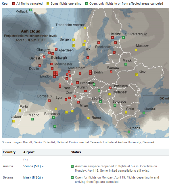
    Anyhow, map of flight impacts from it...

    nytimes1.png

    Naples is beautiful. One of the most beautiful cities in Italy in fact. Parts of the centre and docklands are dodgy but it's mostly very safe.


  • Registered Users Posts: 549 ✭✭✭Manzoor14


    Following on from the Landcover maps above, interactive Corine Landcover 2018 map for Ireland here: Corine 2018

    Heavy dataset so best to zoom in a little (and if your broadband is as slow as mine, wait a few seconds to load!).

    546892.PNG

    Search the layers list down the left for other years and changes from period to period, see attached.


  • Registered Users Posts: 736 ✭✭✭Das Reich


    What a difference between Ireland and Wales.

    15d126e2c8ed417fa729580308f587b1.png


  • Registered Users Posts: 17,819 ✭✭✭✭peasant


    Das Reich wrote: »
    What a difference between Ireland and Wales

    The former border between East and West Germany is also clearly outlined


  • Advertisement
  • Registered Users Posts: 28,812 ✭✭✭✭Quazzie


    My parents were trapped in Naples for over a week during the Eyjafjallajökull ash cloud. Kip of a place to be for any length of time apparently.
    Anyhow, map of flight impacts from it...

    nytimes1.png

    Why is Dublin in Waterford


  • Registered Users Posts: 8,908 ✭✭✭Gregor Samsa


    Quazzie wrote: »
    Why is Dublin in Waterford

    Because the effects of the ash cloud on aviation were beyond the pale.


  • Moderators, Recreation & Hobbies Moderators, Science, Health & Environment Moderators, Technology & Internet Moderators Posts: 90,700 Mod ✭✭✭✭Capt'n Midnight


    3774

    Map of Venus - pretend the blue is ocean if you want to have a Science Fiction planet.


  • Moderators, Recreation & Hobbies Moderators, Science, Health & Environment Moderators, Technology & Internet Moderators Posts: 90,700 Mod ✭✭✭✭Capt'n Midnight


    Geochemical-map-of-mercury-in-European-agricultural-soils-Ap-Anomalies-are-numbered.png

    Map of Mercury


  • Moderators, Politics Moderators Posts: 38,855 Mod ✭✭✭✭Seth Brundle


  • Advertisement
  • Registered Users Posts: 4,381 ✭✭✭KevRossi


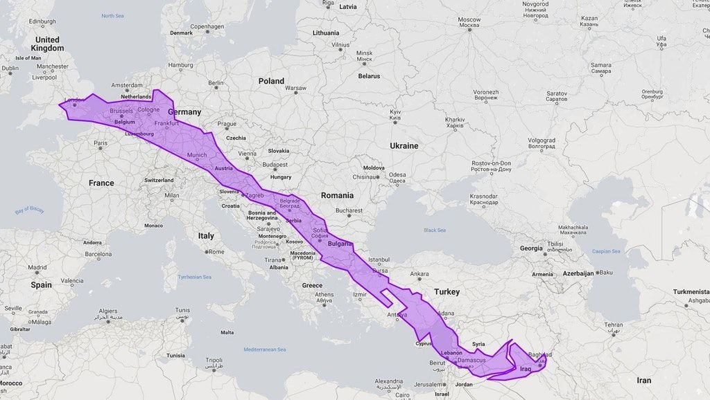
    This one took me by surprise. I've driven to Syria and Lebanon so I've a good idea of the distance in real life. I would never have believed that Chile was this long for some reason.

    Chile and Argentina are first on my bucket list after Nepal and India.

    EwX_202XEAEJqpQ?format=jpg&name=medium


  • Moderators, Category Moderators, Arts Moderators, Sports Moderators Posts: 48,321 CMod ✭✭✭✭magicbastarder


    chile is 4,300km long, and the distance from portmagee in kerry to cape spear, newfoundland, is 3,031km.
    or if you want to get to the US specifically, rather than north america, it's ~4,070km


  • Registered Users Posts: 4,343 ✭✭✭beggars_bush


    KevRossi wrote: »
    This one took me by surprise. I've driven to Syria and Lebanon so I've a good idea of the distance in real life. I would never have believed that Chile was this long for some reason.

    Chile and Argentina are first on my bucket list after Nepal and India.

    EwX_202XEAEJqpQ?format=jpg&name=medium
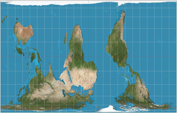
    The mercator map projection would be a big reason people don't realise how big south America and Africa actually are


  • Moderators, Recreation & Hobbies Moderators, Science, Health & Environment Moderators, Technology & Internet Moderators Posts: 90,700 Mod ✭✭✭✭Capt'n Midnight


    The mercator map projection would be a big reason people don't realise how big south America and Africa actually are
    Peters projection works but like every other one some people complain.

    image-20170322-31217-3p4bxk.jpg?ixlib=rb-1.1.0&q=45&auto=format&w=600&h=383&fit=crop&dpr=1


  • Registered Users Posts: 8,166 ✭✭✭Quantum Erasure


    810M5%2Bslt2L._AC_SL1500_.jpg

    https://interestingengineering.com/not-new-earth-authagraph-map-accurate-real-view
    Narukawa explains his design named "World without Ends" in these words:

    "It is able to tile the AuthaGraphic world map without gaps and overlaps. The way of tessellation has seamless connections between maps as if it is an Escher’s tiling. Same as fishes and birds in his painting, six continents are never fragmented and seven oceans keep their continuous networks. It had been thought the world is on an infinite plane since geometries of a sphere and of an infinite plane are similar. Walking on both surfaces, we do not meet an end. A geographical network in the map is able to expand to any directions on the tessellated maps. Thus the world map reproduces the spherical world without dead end on a plane."


    authagraph.com3_.gif


  • Registered Users Posts: 19,678 ✭✭✭✭cnocbui


    Does a great job of portraying why New Zealand was pretty much the last place on earth humans reached and settled.


  • Registered Users Posts: 18,921 ✭✭✭✭BonnieSituation


    This is one of those "why" things that always got me. Two plates just makes sense.

    I used to live in Ottawa and naturally being right on the border with Quebec you would get Quebecer cars coming into the city all the time. It always struck me as one of those difference for difference's sake things that the quebecois would get up to, anyway...

    The weird thing was, that you could mount anything on the front so you would find a lot of PQ or Hab plates etc, but one day I was walking through Ottawa and I had to double-check if I wasn't seeing things, but someone had mounted their Irish licence plate on the front of the car. It was bizarre. The photo is buried somewhere, I hope I come across it again some day. All I remember it was Tipp North anyway.


  • Moderators, Politics Moderators Posts: 38,855 Mod ✭✭✭✭Seth Brundle


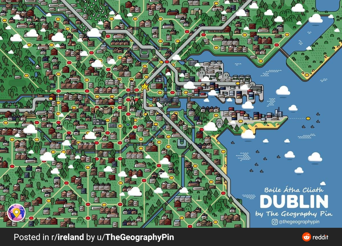
    Dublin in Super Mario map style
    EwhArEdWQAkTLAh?format=jpg&name=medium


  • Registered Users Posts: 5,457 ✭✭✭Charles Babbage


    New Home wrote: »
    I'm lost - why does it say pre-famine, based on 1911 population?

    On a side note, while it's great that more people can speak Irish now, I think it's a shame that the old Irish dialects have been lost.


    Because the map shows the ability of people over 60 in 1911, so they were born before or around the famine.


  • Registered Users Posts: 5,457 ✭✭✭Charles Babbage


    EwTuVWOWQAcWfi5?format=jpg&name=medium

    https://pbs.twimg.com/media/EwTuVWOWQAcWfi5?format=jpg&name=medium

    edit: this also shows a difference between Ireland and Wales.


  • Advertisement
  • Moderators, Category Moderators, Arts Moderators, Sports Moderators Posts: 48,321 CMod ✭✭✭✭magicbastarder


  • Moderators, Arts Moderators, Recreation & Hobbies Moderators, Social & Fun Moderators Posts: 76,351 Mod ✭✭✭✭New Home


    Because the map shows the ability of people over 60 in 1911, so they were born before or around the famine.


    That's fair enough, but my point was that it's hardly accurate, as it doesn't take into account all the people who died or emigrated. All it shows is the number of people over 60 in 1911 who could speak Irish then.


  • Registered Users Posts: 5,457 ✭✭✭Charles Babbage


    New Home wrote: »
    That's fair enough, but my point was that it's hardly accurate, as it doesn't take into account all the people who died or emigrated. All it shows is the number of people over 60 in 1911 who could speak Irish then.


    Unless Irish speakers in a district were more likely to die or emigrate then it is a fair, if not quite perfect, measure of the proportion of Irish speakers in that district. That proportion could be applied to the population in 1841 which may be been a higher.


  • Moderators, Category Moderators, Arts Moderators, Sports Moderators Posts: 48,321 CMod ✭✭✭✭magicbastarder


  • Registered Users Posts: 957 ✭✭✭BloodyBill


    KevRossi wrote: »
    This one took me by surprise. I've driven to Syria and Lebanon so I've a good idea of the distance in real life. I would never have believed that Chile was this long for some reason.

    Chile and Argentina are first on my bucket list after Nepal and India.

    EwX_202XEAEJqpQ?format=jpg&name=medium

    Chile 🇨🇱 was a big disappointment for me. Spent a few months there for work. The main cities are terrible...people relatively unfriendly and the food is dire. Some beautiful parts down south in the Pucon and beyond and the Atacama is worth a visit. Argentina is great...


  • Moderators, Category Moderators, Arts Moderators, Sports Moderators Posts: 48,321 CMod ✭✭✭✭magicbastarder


  • Registered Users Posts: 23,447 ✭✭✭✭Kermit.de.frog


  • Registered Users Posts: 4,381 ✭✭✭KevRossi


    Dublin in Super Mario map style

    Croke Park incorrectly placed there.


  • Registered Users Posts: 4,381 ✭✭✭KevRossi


    Ireland's relatively young population due to 3 factors:

    1. Inward immigration of so many 20 and 30 year olds from the EU and Latin America.
    2. Historically a slightly higher birth rate than many other countries.
    3. Effects of mass migration from the 1950's to 1990's where many of those who left stayed in countries like the UK and have now retired there. Some came home, most did not.


  • Advertisement
  • Registered Users Posts: 18,921 ✭✭✭✭BonnieSituation


    KevRossi wrote: »
    Croke Park incorrectly placed there.

    How so?


Advertisement