Advertisement
If you have a new account but are having problems posting or verifying your account, please email us on hello@boards.ie for help. Thanks :)
Hello all! Please ensure that you are posting a new thread or question in the appropriate forum. The Feedback forum is overwhelmed with questions that are having to be moved elsewhere. If you need help to verify your account contact hello@boards.ie
Hi all! We have been experiencing an issue on site where threads have been missing the latest postings. The platform host Vanilla are working on this issue. A workaround that has been used by some is to navigate back from 1 to 10+ pages to re-sync the thread and this will then show the latest posts. Thanks, Mike.
Hi there,
There is an issue with role permissions that is being worked on at the moment.
If you are having trouble with access or permissions on regional forums please post here to get access: https://www.boards.ie/discussion/2058365403/you-do-not-have-permission-for-that#latest

Interesting Maps

16061636566161

Comments

  • Moderators, Recreation & Hobbies Moderators, Science, Health & Environment Moderators, Technology & Internet Moderators Posts: 92,471 Mod ✭✭✭✭Capt'n Midnight


    zgC0Eey.png

    https://www.nationalgeographic.com/environment/article/theres-a-new-ocean-now-can-you-name-all-five-southern-ocean
    Since National Geographic began making maps in 1915, it has recognized four oceans: the Atlantic, Pacific, Indian, and Arctic Oceans. Starting on June 8, World Oceans Day, it will recognize the Southern Ocean as the world’s fifth ocean.

    “The Southern Ocean has long been recognized by scientists, but because there was never agreement internationally, we never officially recognized it,” says National Geographic Society Geographer Alex Tait.
    ...
    Inside the ACC, the waters are colder and slightly less salty than ocean waters to the north.


  • Posts: 13,688 ✭✭✭✭ Edison Late Hermit


    That would have stumped me in a quiz.


  • Moderators, Recreation & Hobbies Moderators, Science, Health & Environment Moderators, Technology & Internet Moderators Posts: 92,471 Mod ✭✭✭✭Capt'n Midnight


    vR9YJhH.jpg


  • Registered Users Posts: 4,485 ✭✭✭KevRossi


    Hasn't this been the case for a good few years? Maybe National Geographic are just playing catch-up?


  • Registered Users, Registered Users 2 Posts: 9,089 ✭✭✭Gregor Samsa


    KevRossi wrote: »
    Hasn't this been the case for a good few years? Maybe National Geographic are just playing catch-up?

    Yeah, that's the point of the article and the post (see the quote in it). NG are only getting around to recognising it now.


  • Registered Users, Registered Users 2 Posts: 20,110 ✭✭✭✭cnocbui


    KevRossi wrote: »
    Hasn't this been the case for a good few years? Maybe National Geographic are just playing catch-up?

    It has always been referred to as such in Australia, for as long as I can remember.


  • Registered Users Posts: 1,137 ✭✭✭323


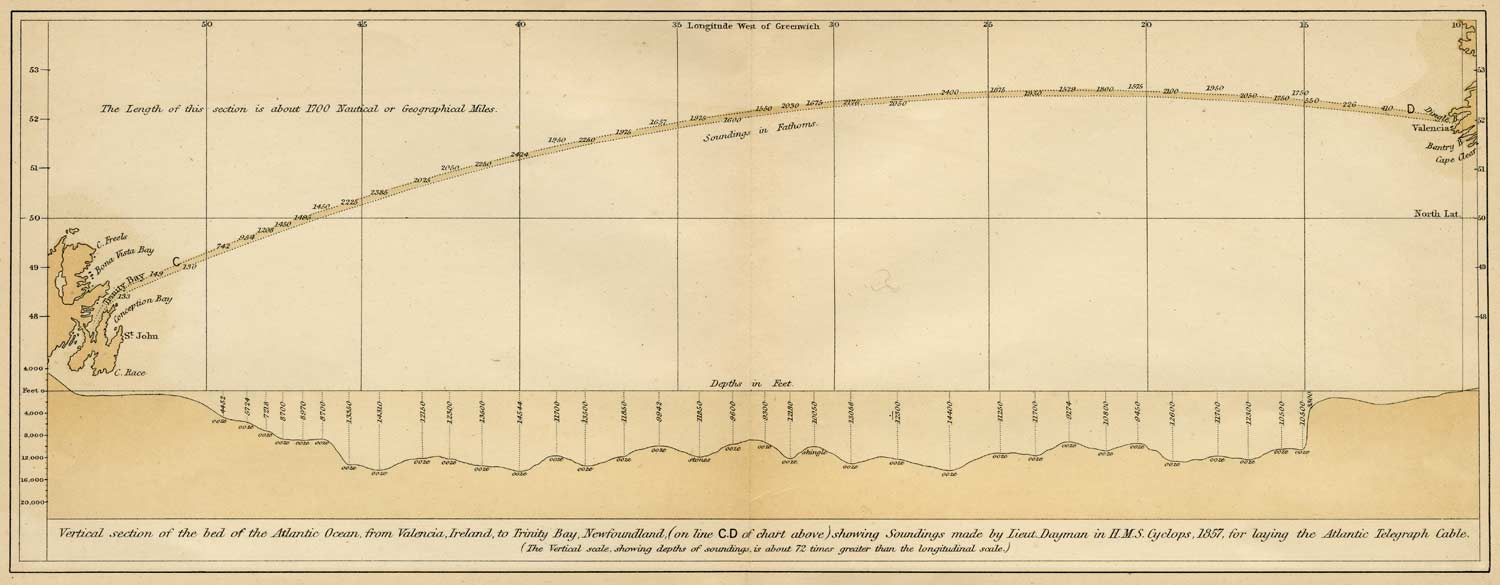
    Interesting series of old maps and links here https://atlantic-cable.com/Maps/


    First one, 1850's, the route survey bathymetry for the first transatlantic cable from Valentia to Newfoundland. Always been interested in these old charts, considering all the data was acquired under sail, lead line soundings, a sextant and a chronometer. The beginning of what would eventually become the internet.


    Blackie-Atlantic-Ocean-1857.jpg

    “Follow the trend lines, not the headlines,”


  • Registered Users, Registered Users 2 Posts: 20,110 ✭✭✭✭cnocbui


    My daughter inherited a pendant from her grandmother which features a cross section of that cable between glass windows.


  • Registered Users, Registered Users 2 Posts: 1,728 ✭✭✭MoodeRator


    The cable consisted of seven copper wires, each weighing 26 kg/km (107 pounds per nautical mile), covered with three coats of gutta-percha (as suggested by Jonathan Nash Hearder[16]), weighing 64 kg/km (261 pounds per nautical mile), and wound with tarred hemp, over which a sheath of 18 strands, each of seven iron wires, was laid in a close helix. It weighed nearly 550 kg/km (1.1 tons per nautical mile), was relatively flexible and was able to withstand a pull of several tens of kilonewtons (several tons).

    The cable from the Gutta Percha Company was armoured separately by wire rope manufacturers, as was the usual practice at the time. In the rush to proceed, only four months were allowed for completion of the cable.[17] As no wire rope maker had the capacity to make so much cable on that timescale, the task was shared by two English firms – Glass, Elliot & Co., of Greenwich, and R.S. Newall and Company, of Birkenhead.[18] Late in manufacturing it was discovered that the respective sections had been made with strands twisted in opposite directions.[19] This meant that the two sections of cable could not be directly spliced wire-to-wire as the iron wire on both cables would unwind when it was put under tension during laying.[20] The problem was easily solved by splicing through an improvised wooden bracket to hold the wires in place,[21] but the mistake subsequently became magnified in the public mind.[19]


  • Moderators, Recreation & Hobbies Moderators, Science, Health & Environment Moderators, Technology & Internet Moderators Posts: 92,471 Mod ✭✭✭✭Capt'n Midnight


    qQKrJr0.png


  • Advertisement
  • Registered Users, Registered Users 2 Posts: 11,400 ✭✭✭✭Collie D


    When did Chicago overtake NY in population? Or have I been under completely wrong impression my whole life?


  • Registered Users, Registered Users 2 Posts: 5,733 ✭✭✭Duckworth_Luas


    Collie D wrote: »
    When did Chicago overtake NY in population? Or have I been under completely wrong impression my whole life?
    It hasn't.

    What they're showing is not Chicago but what is referred to as Chicagoland, the entire urban conurbation that covers Chicago, its suburbs in Illinois and Northern Indiana.

    Some of the people living in this area may never have set foot in Chicago proper in their lives.


  • Registered Users, Registered Users 2 Posts: 3,866 ✭✭✭chooseusername


    It hasn't.

    What they're showing is not Chicago but what is referred to as Chicagoland, the entire urban conurbation that covers Chicago, its suburbs in Illinois and Northern Indiana.

    Some of the people living in this area may never have set foot in Chicago proper in their lives.
    If the same was were to be done for New York , ie; include Newark, New Jersey etc. it would be over 20 million.


  • Registered Users, Registered Users 2 Posts: 14,380 ✭✭✭✭Professor Moriarty


    qQKrJr0.png


    The population density for Ireland is 186 people per square mile. The equivalent population area for New York has a population density of 13. You'd have better craic in Leitrim.


  • Moderators, Category Moderators, Arts Moderators, Sports Moderators Posts: 50,171 CMod ✭✭✭✭magicbastarder


    in the northern territories in canada, population density is 0.1 per sq mile.


  • Registered Users, Registered Users 2 Posts: 3,541 ✭✭✭yagan


    The population density for Ireland is 186 people per square mile. The equivalent population area for New York has a population density of 13. You'd have better craic in Leitrim.
    I think in the maps above it's New York cities and attached burroughs rather than NY state, which can be extremely rural and underpopulated in most parts.


  • Registered Users, Registered Users 2 Posts: 9,089 ✭✭✭Gregor Samsa


    The population density for Ireland is 186 people per square mile. The equivalent population area for New York has a population density of 13. You'd have better craic in Leitrim.

    I’m not sure what you mean here.

    The population density of New York City is 27,000 people per square mile. Even the entire state averages at 412. Maybe there’s some rural areas in the State with only 13 people in a square mile area, but it’s not indicative of the city, or state as a whole entity.

    What do you mean by “equivalent population area”? An area in New York with the same population as Ireland? Or the population of an area of New York with the same size as Ireland?


  • Registered Users, Registered Users 2 Posts: 14,508 ✭✭✭✭retalivity


    I’m not sure what you mean here.

    The population density of New York City is 27,000 people per square mile. Even the entire state averages at 412. Maybe there’s some rural areas in the State with only 13 people in a square mile area, but it’s not indicative of the city, or state as a whole entity.

    What do you mean by “equivalent population area”? An area in New York with the same population as Ireland? Or the population of an area of New York with the same size as Ireland?

    Think the population density of the red area equivalent to the population of new york is 13


  • Registered Users, Registered Users 2 Posts: 9,089 ✭✭✭Gregor Samsa


    retalivity wrote: »
    Think the population density of the red area equivalent to the population of new york is 13

    Ah, I understand now. Obviously haven’t fully woken up yet.


  • Advertisement
  • Posts: 13,688 ✭✭✭✭ Edison Late Hermit


    Ah, I understand now. Obviously haven’t fully woken up yet.

    I wouldn't worry, I've been looking at the map since it was posted and have only just now sussed out what it represents.


  • Registered Users, Registered Users 2 Posts: 14,380 ✭✭✭✭Professor Moriarty


    in the northern territories in canada, population density is 0.1 per sq mile.

    There's a very good reason for that.


  • Moderators, Category Moderators, Arts Moderators, Sports Moderators Posts: 50,171 CMod ✭✭✭✭magicbastarder


    yeah, no one wants to live there because the broadband is appalling.


  • Moderators, Recreation & Hobbies Moderators, Science, Health & Environment Moderators, Technology & Internet Moderators Posts: 92,471 Mod ✭✭✭✭Capt'n Midnight


    yagan wrote: »
    I think in the maps above it's New York cities and attached burroughs rather than NY state, which can be extremely rural and underpopulated in most parts.

    cursedearthmap_low-jpg.115012
    It's Mega City One


  • Moderators, Recreation & Hobbies Moderators, Science, Health & Environment Moderators, Technology & Internet Moderators Posts: 92,471 Mod ✭✭✭✭Capt'n Midnight


  • Registered Users, Registered Users 2 Posts: 20,110 ✭✭✭✭cnocbui


    Pop-density-Canada.jpg

    You could get lonely up there, though the black fly, midges and mosquitos would just love to keep you company. The yanks have a funny name for midges;
    no-see-ums


  • Advertisement
  • Moderators, Recreation & Hobbies Moderators, Science, Health & Environment Moderators, Technology & Internet Moderators Posts: 92,471 Mod ✭✭✭✭Capt'n Midnight


    jDoi1pO.png


    G9LhpoS.jpg


  • Registered Users, Registered Users 2 Posts: 8,743 ✭✭✭Quantum Erasure


    They loved a straight road, the Romans


  • Registered Users, Registered Users 2 Posts: 3,866 ✭✭✭chooseusername


    I can hear the traffic on the V11 , Watling street 4 miles north of Lactodurum (Towcester)
    from the back of my house as I sit here watching the sunset.


  • Registered Users, Registered Users 2 Posts: 3,862 ✭✭✭mikhail


    They loved a straight road, the Romans
    Empires were built and maintained on the back of infrastructure.

    This is the Royal Road of the Persian Empire of 500 BCE. It was a private road - if you travelled on it without warrant you could be killed - with fresh horses at regular waystations that meant a message could travel a nearly absurd 2700 km in 9 days.
    Achaemenid_Empire_at_its_greatest_extent_according_to_Oxford_Atlas_of_World_History_2002.jpg

    Herodotus talked about it in Historia, and a quote from that became the unofficial motto of the US Postal Service. "Neither snow nor rain nor heat nor gloom of night stays these couriers"

    The Royal Road was built by Darius the Great, who invaded Greece only to be stopped by the Athenians at Marathon (the source of the Marathon Run legend, and hence the modern marathon event at the Olympics).

    Darius' son, Xerxes, succeeded him, invaded Greece again, and it was this invasion that was held up by the Spartans (and assorted others at Thermopylae, as depicted wildly inaccurately in the movie 300.

    Herodotus does however back up two of the best quotes in the movie. When Xerxes sent ambassadors to Sparta to demand a symbolic gift of water and earth to signify submission, the Spartan king threw them down a well, saying, "You'll find plenty of both down there". And when the Spartans at Thermopylae were told that the Persian arrows would black out the sun, they replied, "Then we will fight in the shade."


  • Registered Users, Registered Users 2 Posts: 78,490 ✭✭✭✭Victor


    Huge (3000 x 11000 pixels) composite photo of the northern section of the Suez Canal. https://www.esa.int/ESA_Multimedia/Images/2021/06/Suez_Canal_complete


  • Advertisement
  • Registered Users, Registered Users 2 Posts: 5,891 ✭✭✭Charles Babbage


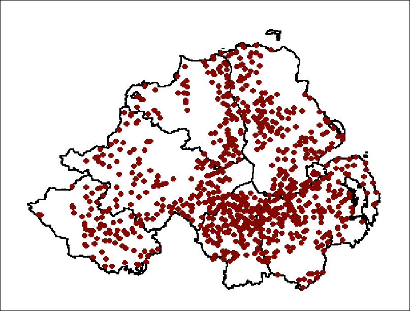
    Orange Lodges in 6 counties, 2001
    maps.h8.gif

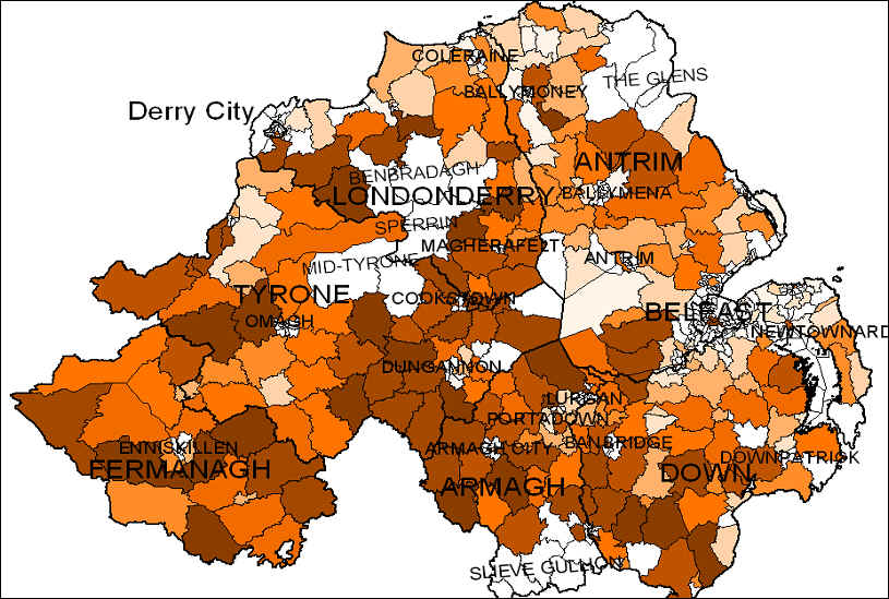
    Orange Density by Ward , Northern Ireland , 1991
    bookma31.jpg

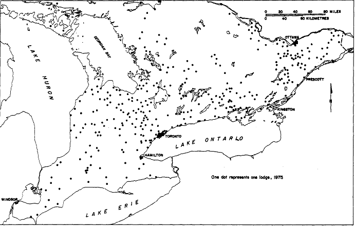
    Orange Lodges in Ontario 1975
    maps.h1.gif


  • Registered Users Posts: 419 ✭✭Mullinabreena


    The Downs survey of Ireland map from the 1600s is quite interesting. I was looking where I live and it's amazing to see the townlands haven't changed in 400 years.

    http://downsurvey.tcd.ie/down-survey-maps.php


  • Registered Users, Registered Users 2 Posts: 14,508 ✭✭✭✭retalivity


    "Protestant Land" everywhere...


  • Registered Users, Registered Users 2 Posts: 5,891 ✭✭✭Charles Babbage


    retalivity wrote: »
    "Protestant Land" everywhere...


    My district is mostly papist, then as now. The reason being the other annotations on the map "mountanie bog" "bogy pasture" "red bog" "turf bog" "bog in comon" "cours rocky pasture" "unprofit" "cours mountaynes", you couldn't "plant" anyone there.


  • Moderators, Recreation & Hobbies Moderators, Science, Health & Environment Moderators, Technology & Internet Moderators Posts: 92,471 Mod ✭✭✭✭Capt'n Midnight


  • Registered Users Posts: 4,485 ✭✭✭KevRossi


    Comparison of the surface area of planets and moons in the Solar System. The colours in the graphic is the average colour of the surface of each body.

    Link here for a better resolution: https://d2pn8kiwq2w21t.cloudfront.net/images/infographicsuploadsinfographicsfull10794.width-1320.jpg

    infographicsuploadsinfographicsfull10794.width-1320.jpg


  • Moderators, Recreation & Hobbies Moderators, Science, Health & Environment Moderators, Technology & Internet Moderators Posts: 92,471 Mod ✭✭✭✭Capt'n Midnight


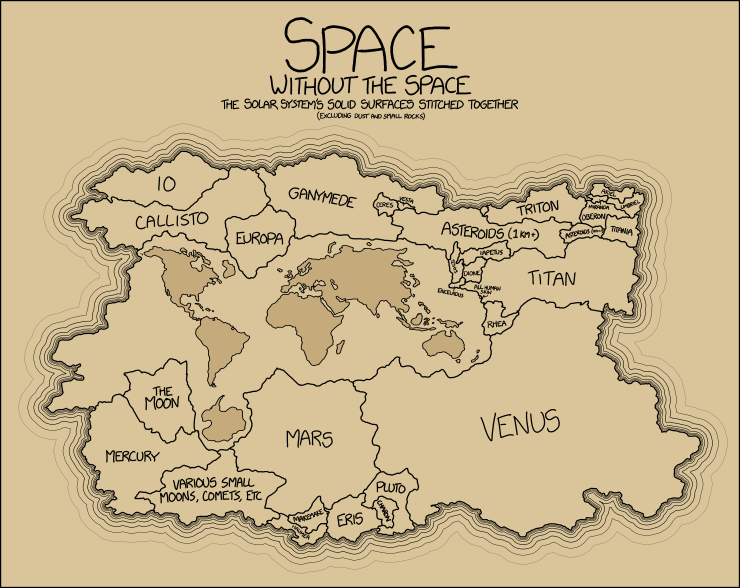
    surface_area.png


    https://explainxkcd.com/1389/
    Non-Solar Bodies
    Between Earth and Titan is a tiny speck noted all human skin, which is an interesting sort of solid surface. A rough estimate of the average body surface area and thus of the average area of all humans skin can be made from these average values and from population pyramids as this pyramid for 2015. Average adults have a skin area of around 1.7-1.8 m2, but as a large part of the human population are children (with skin area down to about 0.25 m2 for infants) the total average will be smaller. By extrapolating the given values an average area of about 1.6 m2 can be found. This would make the area 7.2 billion × 1.6 m2 ≈ 11,500 km2. This is 60 times smaller than the smallest of the labeled moons Miranda (of Uranus) with a surface area of 700,000 km2.


  • Moderators, Recreation & Hobbies Moderators Posts: 21,567 Mod ✭✭✭✭Brian?


    KevRossi wrote: »
    Comparison of the surface area of planets and moons in the Solar System. The colours in the graphic is the average colour of the surface of each body.

    Link here for a better resolution: https://d2pn8kiwq2w21t.cloudfront.net/images/infographicsuploadsinfographicsfull10794.width-1320.jpg

    infographicsuploadsinfographicsfull10794.width-1320.jpg

    Uranus is bleeding massive.


    Sorry.

    they/them/theirs


    And so on, and so on …. - Slavoj Žižek


  • Registered Users, Registered Users 2 Posts: 6,323 ✭✭✭highdef


    Brian? wrote: »
    Uranus is bleeding massive.


    Sorry.

    I've been told that it's lovely.


  • Moderators, Politics Moderators Posts: 40,292 Mod ✭✭✭✭Seth Brundle


    Every ringfort in the Republic of Ireland...
    Ringforts are the most common historical field monument in Ireland with an estimated 45,000 examples identified to date, meaning that Ireland has a ringfort for every 2km² !
    556505.png

    From http://vool.ie/everyringfort/ who are aiming to provide a satellite tweet for each site (https://twitter.com/everyringfort)


  • Advertisement
  • Registered Users, Registered Users 2 Posts: 21,940 ✭✭✭✭Tell me how


    Every ringfort in the Republic of Ireland...


    556505.png

    From http://vool.ie/everyringfort/ who are aiming to provide a satellite tweet for each site (https://twitter.com/everyringfort)

    Wow. Quite the switch in population spread when you look at Connaught region and Leinster compared to how they are today.

    Not saying the ringfort was a direct indicator of population density but you'd think they'd have been linked.


  • Moderators, Recreation & Hobbies Moderators Posts: 21,567 Mod ✭✭✭✭Brian?


    Wow. Quite the switch in population spread when you look at Connaught region and Leinster compared to how they are today.

    Not saying the ringfort was a direct indicator of population density but you'd think they'd have been linked.

    At first glance it looks like they are more dense in flatter areas. No hills to defend. There is also a correlation with the Shannon. Must have been nice fishing.

    they/them/theirs


    And so on, and so on …. - Slavoj Žižek


  • Registered Users Posts: 419 ✭✭Mullinabreena


    Every ringfort in the Republic of Ireland...


    556505.png

    From http://vool.ie/everyringfort/ who are aiming to provide a satellite tweet for each site (https://twitter.com/everyringfort)

    Sadly in the east many ringforts have been destroyed to make way for agriculture. Its happening more in the west then it once did too. In Sligo, Where I live it has one of the highest amount of ringforts, cronogs, neolithic and megalithic structures in Ireland


  • Posts: 0 [Deleted User]


    Brian? wrote: »
    Uranus is bleeding massive.


    Sorry.

    Sorry to say, Uranus looks big in this.


  • Registered Users Posts: 419 ✭✭Mullinabreena


    Mica and Pyrite map of Ireland

    https://www.zeemaps.com/mica_pyrite_mapping


  • Registered Users, Registered Users 2 Posts: 14,154 ✭✭✭✭josip


    Mica and Pyrite map of Ireland

    https://www.zeemaps.com/mica_pyrite_mapping

    Thanks a lot Mullinabreena.
    You sent me down a mica rabbit hole for the last 40 minutes which means I'm now the country's leading expert on Cassidy Bros and their mica blocks.
    https://www.boards.ie/vbulletin/showthread.php?t=2057901409&page=87


  • Registered Users, Registered Users 2 Posts: 1,026 ✭✭✭farmchoice


    Mica and Pyrite map of Ireland

    https://www.zeemaps.com/mica_pyrite_mapping


    thats very interesting. the most interesting thing is one house in a very large estate in dunboye has pyrite and another one in Gorey

    now if you were from north mayo you would by now understand that if one house in an estate has its almost certain that if not every house has it then the vast majority of them do.
    this is the such big news it should be the headline on the 9 o clock news and on the front of every paper.
    because if one estate in dunboye has it and one in gorey its highly likely that dozens and dozens of other estates have it, possibly tens of thousands of houses.


    mayo and donegal are only the tip of the iceberg. the quarry in mayo that produced the pyrite blocks sent them all over Ireland.


    this could cost more than bailing out the banks.


  • Registered Users, Registered Users 2 Posts: 1,570 ✭✭✭MyStubbleItches


    There’s one house in Cork, happens to be in my locality. No new house built there so I’m wondering if it’s an older problem. How is it reported does anyone know?


  • Registered Users, Registered Users 2 Posts: 2,984 ✭✭✭Stovepipe


    possibly because of the cement portion in the mix. I was told by someone in the building business that a greater percentage of cement in the blocks nullifies the effects of mica. How true that is, I don't know.


  • Advertisement
  • Registered Users, Registered Users 2 Posts: 10,240 ✭✭✭✭Hurrache


    Mica and Pyrite map of Ireland

    https://www.zeemaps.com/mica_pyrite_mapping

    Doesn't seem very accurate at all when it comes to pyrite. There's plenty around the Leinster region and yet there's just the one in Dunboyne on the map.


Advertisement