Advertisement
If you have a new account but are having problems posting or verifying your account, please email us on hello@boards.ie for help. Thanks :)
Hello all! Please ensure that you are posting a new thread or question in the appropriate forum. The Feedback forum is overwhelmed with questions that are having to be moved elsewhere. If you need help to verify your account contact hello@boards.ie
Hi all! We have been experiencing an issue on site where threads have been missing the latest postings. The platform host Vanilla are working on this issue. A workaround that has been used by some is to navigate back from 1 to 10+ pages to re-sync the thread and this will then show the latest posts. Thanks, Mike.
Hi there,
There is an issue with role permissions that is being worked on at the moment.
If you are having trouble with access or permissions on regional forums please post here to get access: https://www.boards.ie/discussion/2058365403/you-do-not-have-permission-for-that#latest

Interesting Maps

15859616364161

Comments

  • Posts: 0 [Deleted User]


    I'm aware of the history thanks. There is no way that the german troops in finland could be said to be occupying the country. would you say that the 1.6m US troops in Britain duriing WW2 were occupying the country?

    They were certainly occupying the minds of lots of Tommies. Overpaid, and Over sexed. :pac:


  • Registered Users, Registered Users 2 Posts: 11,690 ✭✭✭✭Skylinehead


    I'm aware of the history thanks. There is no way that the german troops in finland could be said to be occupying the country. would you say that the 1.6m US troops in Britain duriing WW2 were occupying the country?

    No, as Britain and the US weren't at war. Finland and Germany were in 1944, so that's a fairly poor example.

    The Germans, while withdrawing through Finland once the Finns started pushing them out, were using scorched earth tactics and demolished a serious amount of infrastructure in Lapland. They fought in Finland against Finland. How, in any sense of the word, were they not occupying that land?


  • Registered Users, Registered Users 2 Posts: 40,513 ✭✭✭✭ohnonotgmail


    No, as Britain and the US weren't at war. Finland and Germany were in 1944, so that's a fairly poor example.

    The Germans, while withdrawing through Finland once the Finns started pushing them out, were using scorched earth tactics and demolished a serious amount of infrastructure in Lapland. They fought in Finland against Finland. How, in any sense of the word, were they not occupying that land?

    running for your lives through a country is not occupying it. anyway, best to leave it there.


  • Registered Users, Registered Users 2 Posts: 11,690 ✭✭✭✭Skylinehead


    running for your lives through a country is not occupying it. anyway, best to leave it there.

    Fair enough. Not an invasion, I'd agree there, but they were accidental occupiers until they were ran out of the place :D


  • Moderators, Recreation & Hobbies Moderators Posts: 21,563 Mod ✭✭✭✭Brian?


    Putain is considered stronger than merde, combining them is putain de merde, which is saved for the worst case scenarios :D

    The kid friendly versions of these you often hear are puree (=mashed potatoes) or mercedi (=wedensday).

    Interestingly in Quebec they done use Putain or merde, they use tabarnac. The swear words are religious paraphernalia

    they/them/theirs


    And so on, and so on …. - Slavoj Žižek


  • Advertisement
  • Moderators, Arts Moderators, Recreation & Hobbies Moderators, Social & Fun Moderators Posts: 77,020 Mod ✭✭✭✭New Home


    Putain is considered stronger than merde, combining them is putain de merde, which is saved for the worst case scenarios :D

    The kid friendly versions of these you often hear are puree (=mashed potatoes) or mercedi (=wedensday).

    A bit like "sugar" is used here instead of "sh!t". I love the idea of purée and mercredi, they're brilliant!:D


  • Moderators, Category Moderators, Arts Moderators, Sports Moderators Posts: 50,158 CMod ✭✭✭✭magicbastarder


    mercredi is amusingly like sanitising one of ours to 'see you next tuesday'


  • Registered Users, Registered Users 2 Posts: 911 ✭✭✭Flying Abruptly


    I can't think of the sanitised version of con or connasse (see you next tuesday) in french, they just use that one!:D


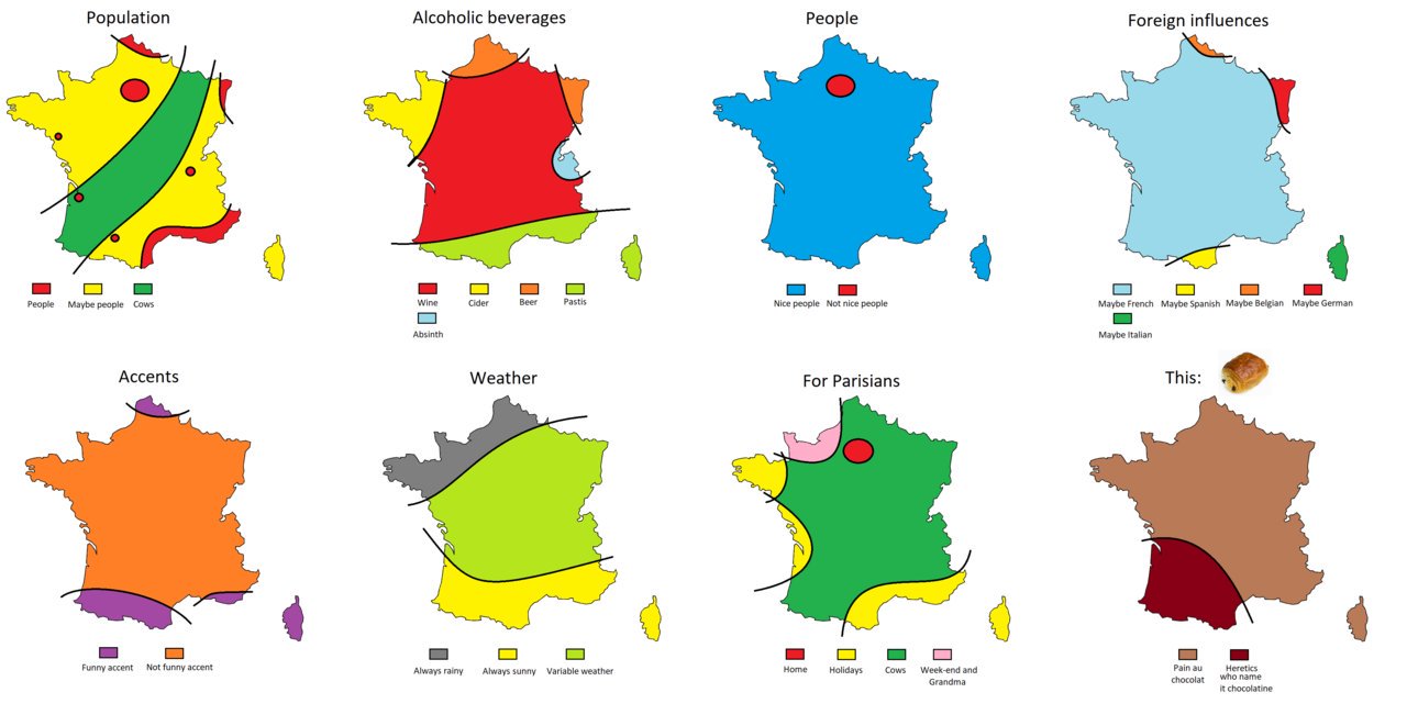
    Keeping on the french theme:
    DaYdqqoX4AAUxEb?format=jpg&name=large
    Third one can also be:
    e64as8nid4141.jpg


  • Registered Users, Registered Users 2 Posts: 40,513 ✭✭✭✭ohnonotgmail


    I wasn't aware of the pain au chocolat vs chocolatine controversy. They seem to take it very seriously in Bordeaux where chocolatine predominates

    https://twitter.com/SultanPopi/status/888016273237585921


  • Posts: 0 [Deleted User]


    I wasn't aware of the pain au chocolat vs chocolatine controversy. They seem to take it very seriously in Bordeaux where chocolatine predominates

    https://twitter.com/SultanPopi/status/888016273237585921

    Brilliant. That could feature in the YLYL thread.


  • Advertisement
  • Registered Users, Registered Users 2 Posts: 911 ✭✭✭Flying Abruptly


    I wasn't aware of the pain au chocolat vs chocolatine controversy. They seem to take it very seriously in Bordeaux where chocolatine predominates


    You will be refused service around Toulouse if you ask for a pain au chocolat!


  • Registered Users Posts: 419 ✭✭Mullinabreena


    Map of Ireland showing the distribution of the
    records of the Archaeological Survey of Ireland.

    Screenshot-20210514-223901-Drive.jpg


    https://maps.archaeology.ie/HistoricEnvironment/


  • Registered Users, Registered Users 2 Posts: 40,513 ✭✭✭✭ohnonotgmail


    why so few in the west and donegal?


  • Moderators, Category Moderators, Arts Moderators, Sports Moderators Posts: 50,158 CMod ✭✭✭✭magicbastarder


    wicklow mountains are also sparse. probably boggy uplands.


  • Registered Users, Registered Users 2 Posts: 4,413 ✭✭✭silliussoddius


    wicklow mountains are also sparse. probably boggy uplands.

    Yeah. And maybe because it’s Donegal.
    in the case of Donegal there is more “through the gap” in the East where it isn’t as rugged.


  • Moderators, Category Moderators, Arts Moderators, Sports Moderators Posts: 50,158 CMod ✭✭✭✭magicbastarder


    yep, worth considering that the archaeology which is known depends on several factors; where people actually lived and worked, and whether the artefacts of that were likely to survive; whether they're accessible, etc.


  • Registered Users Posts: 441 ✭✭forgottenhills


    yep, worth considering that the archaeology which is known depends on several factors; where people actually lived and worked, and whether the artefacts of that were likely to survive; whether they're accessible, etc.

    Yes definitely where people lived. If you zoom in on the map many of those red dots are ring forts. Ring forts seem to be typically situated on small hills but not mountains so I'd imagine people were rounding up their precious cattle and minding them at night from all these cattle raids mentioned in the annals etc. Cattle need grass and you also need to be able to find them and round them up easily, neither are possible in areas of high mountains.


  • Registered Users Posts: 419 ✭✭Mullinabreena


    why so few in the west and donegal?
    With the exception of uplands and bog I find it interesting how the west of the compares to the east. It would appear that the west has more archaeological survey sites. The east generally would have better land so historically more settlements? Its also more developed so you would imagine more sites would be discovered.


  • Registered Users, Registered Users 2 Posts: 14,379 ✭✭✭✭Professor Moriarty


    Yes definitely where people lived. If you zoom in on the map many of those red dots are ring forts. Ring forts seem to be typically situated on small hills but not mountains so I'd imagine people were rounding up their precious cattle and minding them at night from all these cattle raids mentioned in the annals etc. Cattle need grass and you also need to be able to find them and round them up easily, neither are possible in areas of high mountains.

    Post content = poster username.


  • Registered Users Posts: 4,485 ✭✭✭KevRossi


    In other news the OPW have opened all sites in Ireland free of charge until the end of the year.

    There's a map here, so no excuses for not finding out a bit more about our history. I had the OPW annual card a couple of times and it's excellent value.

    https://heritageireland.ie/visit/places-to-visit/?map=true


  • Advertisement
  • Registered Users Posts: 1,298 ✭✭✭RedRochey


    Unteeeitled-1-1024x437.jpg

    Irelands most remote location, "A boggy hillside in the Nephin Beg mountains in Mayo. This point is just under 8km from the nearest road." https://goo.gl/maps/UM1RGwspJYv

    https://threerockbooks.com/irelands-remote-point/


  • Registered Users, Registered Users 2 Posts: 2,793 ✭✭✭Bogwoppit


    RedRochey wrote: »
    Unteeeitled-1-1024x437.jpg

    Irelands most remote location, "A boggy hillside in the Nephin Beg mountains in Mayo. This point is just under 8km from the nearest road." https://goo.gl/maps/UM1RGwspJYv

    https://threerockbooks.com/irelands-remote-point/

    I’ve been up there, it’s a pretty nice spot.


  • Registered Users, Registered Users 2 Posts: 2,381 ✭✭✭Westernyelp


    Bogwoppit wrote:
    I’ve been up there, it’s a pretty nice spot.


    Me too. Bangor trailvand surrounds is a great walk if you ever get the chance


  • Registered Users, Registered Users 2 Posts: 5,342 ✭✭✭Padre_Pio


    yep, worth considering that the archaeology which is known depends on several factors; where people actually lived and worked, and whether the artefacts of that were likely to survive; whether they're accessible, etc.

    Also where people are living now, areas of continuous habitation repeatedly destroy older settlements.
    Also construction turns up many sites. Areas that are largely isolated now have less modern construction and surveys.

    Seems to be some lines that correspond with motorways, but I expected to see more around the M1/M7/M8


  • Registered Users, Registered Users 2 Posts: 78,490 ✭✭✭✭Victor


    Roads in west Dublin known as Cloverhill Road.

    553522.png
    © OpenStreetMap contributors


  • Registered Users, Registered Users 2 Posts: 40,513 ✭✭✭✭ohnonotgmail


    Victor wrote: »
    Roads in west Dublin known as Cloverhill Road.

    553522.png
    © OpenStreetMap contributors

    One of them is CloverHill Road. The other is Clover Hill Road.


  • Registered Users, Registered Users 2 Posts: 78,490 ✭✭✭✭Victor


    One of them is CloverHill Road. The other is Clover Hill Road.
    Eircode, Ordnance Survey and both councils seem to call both of them Cloverhill Road.


  • Registered Users, Registered Users 2 Posts: 40,513 ✭✭✭✭ohnonotgmail


    Victor wrote: »
    Eircode, Ordnance Survey and both councils seem to call both of them Cloverhill Road.

    weird, google maps has it as Clover Hill Road.


  • Moderators, Politics Moderators Posts: 40,287 Mod ✭✭✭✭Seth Brundle


    weird, google maps has it as Clover Hill Road.
    It also has part of one of them as Station Rd :)


  • Advertisement
  • Registered Users, Registered Users 2 Posts: 78,490 ✭✭✭✭Victor


    It also has part of one of them as Station Rd :)
    Cloverhill Road is the road according to the council, Station Road is the address of the houses. Unfortunately, this is common enough in Ireland.

    ¯\_(ツ)_/¯


  • Registered Users Posts: 4,597 ✭✭✭dan1895


    https://twitter.com/KPD_1895/status/1395699174788710403?s=19

    Every country Shelbourne FC have played a European tie in.


  • Moderators, Sports Moderators Posts: 7,264 Mod ✭✭✭✭cdeb


    Probably technically they've played the odd one or two in Ireland as well?

    (Except that one against Rangers of course)


  • Registered Users Posts: 5,382 ✭✭✭Duffy the Vampire Slayer


    Putain is considered stronger than merde, combining them is putain de merde, which is saved for the worst case scenarios :D

    The kid friendly versions of these you often hear are puree (=mashed potatoes) or mercedi (=wedensday).

    Similarly, Spanish speakers say "miercoles" (Wednesday) in place of "mierda" (****).


  • Registered Users Posts: 4,597 ✭✭✭dan1895


    cdeb wrote: »
    Probably technically they've played the odd one or two in Ireland as well?

    (Except that one against Rangers of course)

    Everywhere but Ireland. England is red because the game against Rangers was in Birkenhead.


  • Closed Accounts Posts: 168 ✭✭Fake Scores


    E19-Hqtt-Xs-AEEqao-jpeg.jpg


  • Advertisement
  • Registered Users Posts: 4,485 ✭✭✭KevRossi


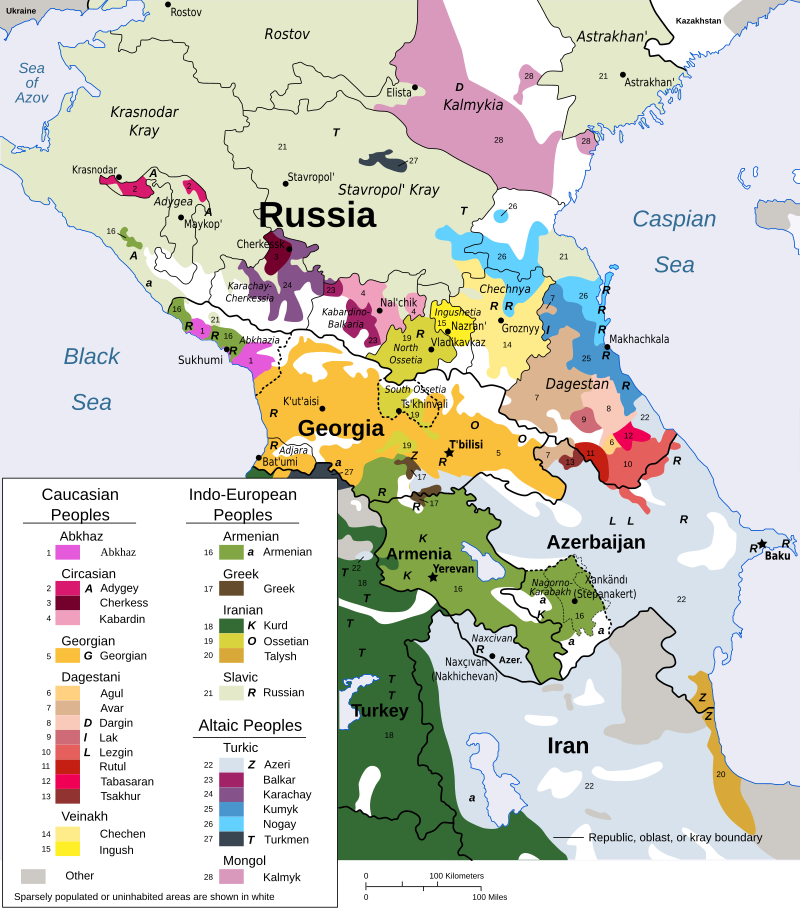
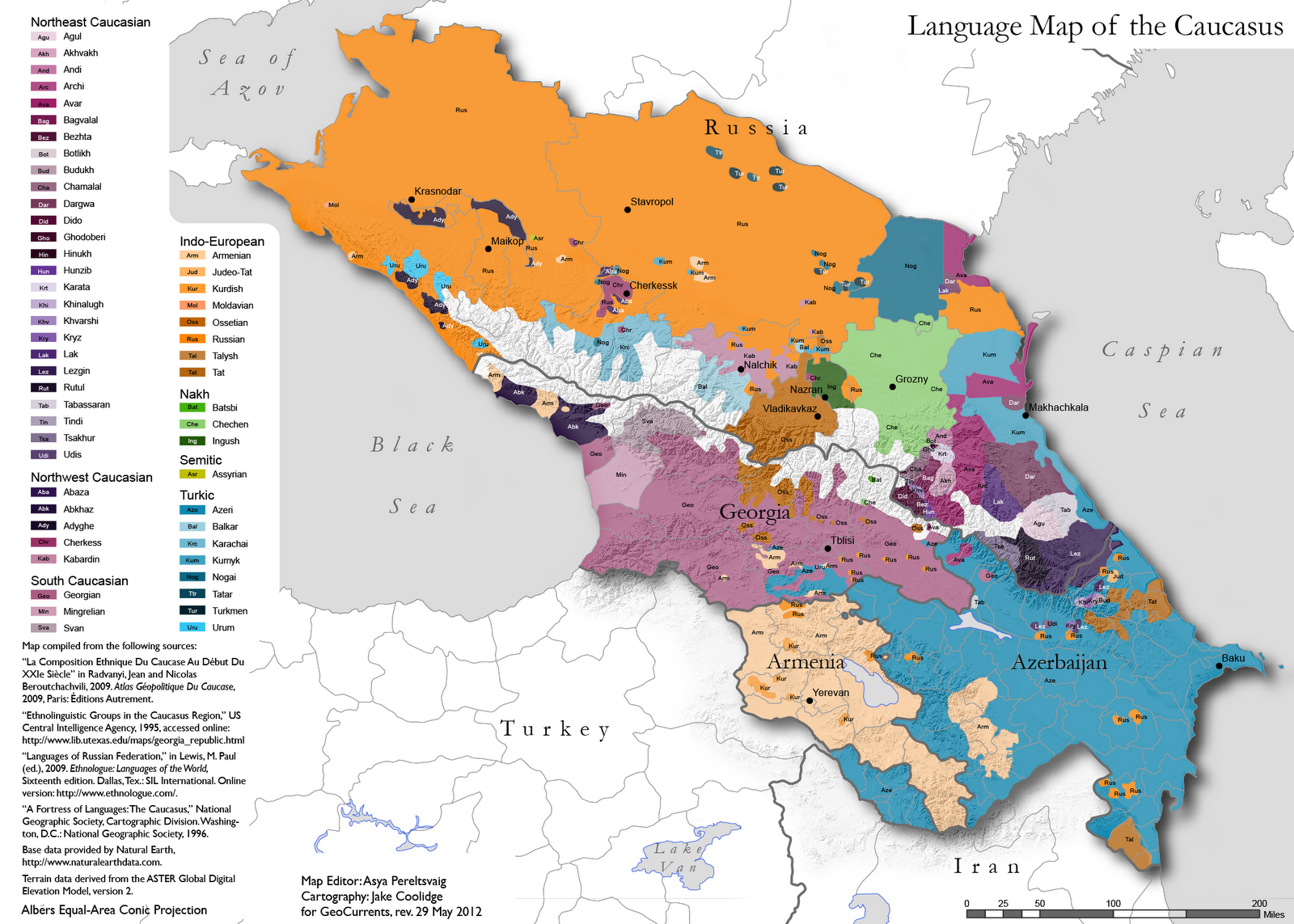
    A map of ethnic groups in the Caucas region. One of the most incredibly diverse places on earth.

    For reference, the map measures about 1,200 km (N-S) x 900 km (E-W).


    800px-Caucasus-ethnic_en.svg.png


  • Registered Users, Registered Users 2 Posts: 4,796 ✭✭✭ablelocks


  • Moderators, Social & Fun Moderators Posts: 12,887 Mod ✭✭✭✭JupiterKid


    Map of Eurovision Song Contest winning countries, 1956-2021

    11417_zcmiuzjqoc5vfpow.jpeg


  • Registered Users, Registered Users 2 Posts: 19,085 ✭✭✭✭BonnieSituation


    JupiterKid wrote: »
    Map of Eurovision Song Contest winning countries, 1956-2020

    11417_zcmiuzjqoc5vfpow.jpeg

    Every year since we've been in the doldrums and Sweden got to 6 I've been fiercely anti-Sweden during the contest.

    The early 90s were frankly insane with us. 94 being the obvious peak.


  • Registered Users, Registered Users 2 Posts: 8,616 ✭✭✭Gloomtastic!


    ^ I thought Iceland won once. :confused: Why is Croatia shaded differently?


  • Advertisement
  • Registered Users, Registered Users 2 Posts: 78,490 ✭✭✭✭Victor


    ^ I thought Iceland won once. :confused: Why is Croatia shaded differently?
    I think the act won when they represented Yugoslavia, not Croatia.


  • Registered Users, Registered Users 2 Posts: 19,085 ✭✭✭✭BonnieSituation


    ^ I thought Iceland won once. :confused: Why is Croatia shaded differently?

    Yugoslavia won it in 1989.

    In 1990 it was hosted in Zagreb, so it's a logical place to put the Yugoslav win I guess.

    Iceland have never won it.


  • Registered Users, Registered Users 2 Posts: 8,738 ✭✭✭Quantum Erasure


    ^ I thought Iceland won once. :confused: Why is Croatia shaded differently?

    The Yugoslav winner in 1989 was from Croatia


  • Registered Users, Registered Users 2 Posts: 4,413 ✭✭✭silliussoddius


    KevRossi wrote: »
    A map of ethnic groups in the Caucas region. One of the most incredibly diverse places on earth.

    For reference, the map measures about 1,200 km (N-S) x 900 km (E-W).


    800px-Caucasus-ethnic_en.svg.png


    Similar, with more detail. I think the term Altaic is no longer used and Turkic is considered more accurate.

    CaucasusLayout_rev.png


  • Registered Users, Registered Users 2 Posts: 8,960 ✭✭✭blackwhite


    Iceland have never won it.

    Not even with Ja Ja Ding Dong?


  • Registered Users Posts: 4,485 ✭✭✭KevRossi


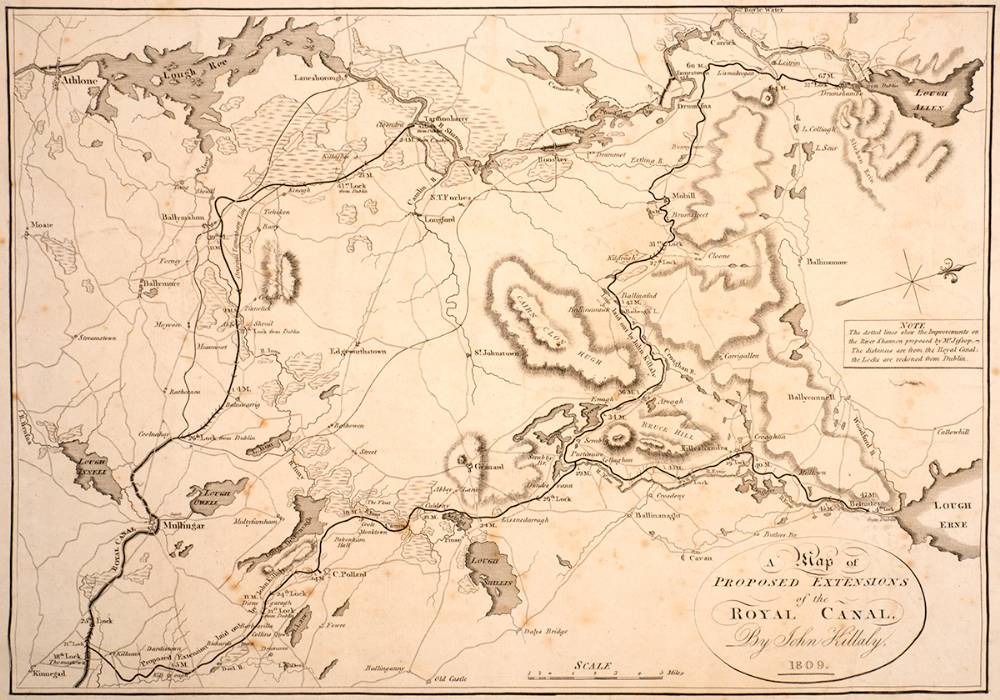
    A map of a proposed extension of the Royal Canal, from Kinnegad to Lough Allen and Lough Erne from 1809.

    (The map is on it's side, so the top of the page is 'West'.

    60842.jpg


  • Moderators, Politics Moderators Posts: 40,287 Mod ✭✭✭✭Seth Brundle


  • Moderators, Politics Moderators Posts: 40,287 Mod ✭✭✭✭Seth Brundle


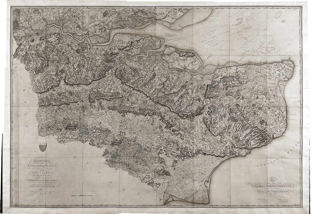
    An Entirely New & Accurate Survey Of The County Of Kent, With Part Of The County Of Essex was created by William Mudge in 1801 and is regarded at the first official Ordnance Survey (UK) map.
    Following a rebellion in 1745 in the Scottish Highlands, our origins were established in military strategy. These roots developed over time and, as the French Revolution was causing increased fear for the government, its defence ministry was ordered to begin a survey of England’s most exposed southern coasts to protect the nation. The name of this ministry was, yes you guessed it, the Board of Ordnance!

    At the time Kent, England’s most south-easterly county, was identified to have had the most vulnerability in its coast line and therefore the highest susceptibility to the French invasion. As a result, the first map we ever made was of Kent in 1801. It focused on communication routes and included hill shading to ensure men at arms could interpret the landscape with precision. Over time, this map design became less focused on these elements and was developed to appeal to a much wider audience.

    Produced to a scale of one inch to one mile, the map took three years to complete and was finished in the drawing room at our original offices, the Tower of London. It was printed by William Faden of Charing Cross, a then leading cartographer and map publisher.

    At this time, maps were engraved back to front on copper plates and separate legends were created for the symbols as the maps were big enough without them. The first maps were sold at three guineas (£3 3s) per county survey, which was between one and three weeks’ wages for the average person.
    https://www.ordnancesurvey.co.uk/newsroom/blog/the-beginning-of-our-paper-maps?utm_source=twitter&utm_medium=social&utm_term=&utm_content=&utm_campaign=69bfe499-6521-4724-a0d8-0ff9f8bc2354

    6210633144_3db0f0d60f_b.jpg


  • Registered Users, Registered Users 2 Posts: 5,890 ✭✭✭Charles Babbage


    European purchasing power

    main-qimg-4abdcc9b4bbea83d13910a1ad0f8346e


  • Registered Users, Registered Users 2 Posts: 14,506 ✭✭✭✭retalivity


    Looks like they cheated and just made everywhere in Iceland and Norway red and everywhere in Ukraine and Belarus blue.
    No overspill at the old Iron curtain borders either, between the Baltic and the Adriatic


  • Advertisement
Advertisement