Advertisement
If you have a new account but are having problems posting or verifying your account, please email us on hello@boards.ie for help. Thanks :)
Hello all! Please ensure that you are posting a new thread or question in the appropriate forum. The Feedback forum is overwhelmed with questions that are having to be moved elsewhere. If you need help to verify your account contact hello@boards.ie
Hi all! We have been experiencing an issue on site where threads have been missing the latest postings. The platform host Vanilla are working on this issue. A workaround that has been used by some is to navigate back from 1 to 10+ pages to re-sync the thread and this will then show the latest posts. Thanks, Mike.
Hi there,
There is an issue with role permissions that is being worked on at the moment.
If you are having trouble with access or permissions on regional forums please post here to get access: https://www.boards.ie/discussion/2058365403/you-do-not-have-permission-for-that#latest
There is an issue with role permissions that is being worked on at the moment.
If you are having trouble with access or permissions on regional forums please post here to get access: https://www.boards.ie/discussion/2058365403/you-do-not-have-permission-for-that#latest
Your daily forecasts from Boards.ie weather forum (NO CHAT)
Comments
-
UPDATE _ Friday, 6 p.m.
_____________________
Just to confirm that very windy conditions will develop overnight in western counties and this will spread to most other parts of Ireland Saturday morning. Winds are gusting to 60 mph already at the offshore M6 buoy located near 15 W to the west of Galway.
Showery and mild here today.0 -
Saturday, 7 November, 2009
_____________________________
TODAY will be very windy (WSW veering WNW) especially near the west coast where gusts to 70 mph are possible later this morning and around mid-day. Further inland gusts to about 45 or 50 mph are likely, and the east coast may see peak winds of about 40 mph. However, passing squally showers could produce higher gusts locally anywhere in the country. Hail and thunder are possible as well, together with some brief sunny intervals. Highs will reach about 10-11 C, but it will feel more like 2-5 C out in the wind.
TONIGHT will see gradually abating NW winds of 20-40 mph and a few lighter showers dying out, with some clearing towards morning in eastern counties. Lows will reach about 2-5 C with some scattered frost.
SUNDAY will be partly cloudy to overcast and rather cool still, despite much lighter (northerly) winds. Low cloud and drizzle may return to Ulster and some other northern and western districts. Highs will reach about 11-12 C.
MONDAY will have a clear, frosty start with lows of -3 to +2 C in many areasm but 4-6 C in sheltered urban and coastal locations. Cloud will gradually spread in from west to east followed by light rain at times in the west by afternoon or evening. Highs will reach about 12 C.
TUESDAY will start out wet with some chance of clearing as a slow-moving ridge sets up over the west coast by evening. Highs will be near 11 C.
From Wednesday to Saturday, it is likely to be windy and wet much of the time with the risk of some heavy rainfalls and very strong winds (something to be watched around Friday 13th of all days).
Following is my Winter Outlook for Ireland
On the whole, I expect this to be a slightly colder than average winter in Ireland, with some very cold periods in mid to late December and in parts of mid-January as well. Milder periods will occur in early December, around new years, and from the end of January through much of February.
In the colder periods, some lying snow is possible. There may be one or two days with snow in later November, then look for a better chance in the week before Christmas, and a very good chance for snow from about the 10th of January to 25th of January, not necessarily all through that period, but perhaps on more than one occasion during it.
Some of the milder days may be accompanied by heavy rains and high winds. During the expected mild spell in early December, I think the storm track will at first run well north of Ireland but if not, strong winds could be expected around the 2nd and 5th. Later on, towards the 15th, there would be a good chance of a strong wind event as the milder spell transitions to the expected colder weather.
Another time to look for strong winds would be around New Years Eve and Day when I expect a strong low to be present somewhere near northern parts of Ireland and western Scotland.
A period around 14-15 January may be stormy with mixed or snowy precipitation as well as strong winds. Then towards the end of January, there may be very strong winds and rain with a return to milder conditions.
February by contrast may be a rather bland month, especially if it doesn't snow in the first few days like last year. I believe that January will be the best "winter" month in the winter of 2009-10.
If I change any details of this outlook due to new information coming into my research or obvious signs of a different outcome, I will relay those as soon as possible in future posts.
Weather here today was cloudy, occasional rain, high about 12 C with moderate westerly winds.0 -
Sunday, 8 November, 2009
___________________________
TODAY will be much improved mainly due to the lighter winds, as well as some sunny breaks, and only a few light showers mainly in the southwest. Highs will be around 11 or 12 C.
TONIGHT will feature some local frost and clear skies with some higher cloud about, lows of -3 to +2 C in most rural areas, 3-6 C in more sheltered locations near the coast or in larger cities. Cloud will thicken in the west. Some sleety rain may develop in the west coastal counties.
MONDAY will see cloud spreading across Ireland fairly soon after sunrise in the east, and rain (perhaps starting as sleet on higher ground) will follow fairly readily, overspreading all but perhaps Ulster by early afternoon. Winds will pick up from the south and it will feel rather raw despite highs of 10-12 C.
TUESDAY will see the rain ending in the early morning in eastern counties, but it may stay cloudy in some eastern counties for the morning hours, while some sunshine develops further west. Lows will depend on the time of clearing, 2-5 C will be the general range. Highs will reach about 10-12 C.
WEDNESDAY to FRIDAY are looking cloudy, rainy at times, and rather windy. A complex and deep storm system is still being featured for Friday night and Saturday morning in areas either over or just to the south of Ireland; stay tuned for the evolving forecasts on that system.
My local weather on Saturday was mostly cloudy with periods of rain, and a rather chilly high of about 9 C.
--- Just a note, I may not be very regular in my forecast posting on Monday and possibly into mid-week; some family business is taking me on a brief long-distance road trip and I'm not sure how much internet access I will find. Perhaps some of the other boards forecasters could look in and add some forecasts if they see the need. Thanks in advance. -- MTC.0 -
Hi MT. RTE weather actually called this storm earlier in the week, tuesday if i remember correctly. Surprised me a bit in that they would mention it so far out. They mentioned Thurday night / Friday, so they are about 24hrs out, but still a good call.
Look pretty potent at the moment, but still a long way off.
Anyway, hope the weather gods look kindly on you during your journey.")
 0
0 -
MT, take a break bud, posting at 6.25am on a Sunday...0
-
-
Yep, don't worry about old MTC overworking himself at odd hours, I am eight hours behind the real world ... so the morning forecasts fit into my day rather easily at around 9-10 pm when I also work on a forecast for a UK forum.
Just wanted to mention that the Friday or Saturday monster storm event seems to have vanished from the 12z runs of the GFS and GEM models, but I haven't seen the 12z ECM yet (it comes in a bit later), and I won't have that opportunity as I am about to head out on this long road trip. For that same reason, my Monday morning forecast may not appear on time or even at all, so if any of the usual suspects would like to have a go at a Monday forecast at any point (even late this evening) please do, it would be greatly appreciated. I hope to keep up with the situation from later Monday on, so "see you then." Weather here is raining and about 7 C, probably snowing above 500 metres in the local mountains, which is good if we are going to stage these winter Olympics on real snow and not the man-made variety.0 -
An occluding low pressure system over the East Atlantic will affect the British Isles in the afternoon / evening hours. The cold front which should cross Ireland during Monday afternoon is forecast to weaken, but some low-end instability near the occlusion point may lead to showers and thunderstorms over SW Ireland, Wales, SW / S England and extreme NW France. Other regions remain rather quiet as cold air overspreads large portions of eastern and central Europe and an upper ridge stretches northeastward from Iberia towards France.
DISCUSSION
...SW Ireland, Irish Sea, Wales, SW England, extreme NW France...
Ahead of the cold front of an occluding surface low, a few hundred J/kg are forecast in a region with strong deep layer shear and enhanced SRH3. Storms will probably organise into multicellular lines which may produce an isolated severe gust and / or a brief tornado but overall storm coverage is probably too low for a level 1.
Strong deep layer shear and a few hundred J/kg CAPE are also forecast for the S Bay of Biscay but rather weak QG forcing as well as low level CAA in the wake of the trough should limit the potential of severe thunderstorms. An isolated severe gust is not ruled out, though.0 -
Very wet MONDAY
drier TUESDAY
dry then wet WEDNESDAY
showery THURSDAY AND FRIDAY windy too
SATURDAY slight storm risk in South
system admin
http://weathergossip.com0 -
Advertisement
-
TUESDAY, 10 NOVEMBER, 2009
__________________________
Just an abbreviated forecast from me this morning ...
TODAY should see some partial clearing from west to east and some fairly long sunny intervals could develop, with highs near 11 C.
From tonight to about Friday evening, it will be raining off and on and winds will increase gradually from about 20-30 mph (SE) on Wednesday to 35-45 mph (SSW) on Friday. Although the major storm potential was dropped by the models on Monday, it still looks possible that there could be a period of stronger winds some time Friday. In any case, temperatures will be rather mild in this wet period, 12-14 C.
The weekend looks a bit more showery than a steady rain, with highs around 13 C.
I will continue to try to look in on the forecast until I get home late Wednesday. Where I am now, it has been about 4 C all day with rain since mid-afternoon, and snow falling on nearby mountains just above my current elevation (which is about 400 m asl).0 -
WEDNESDAY, 11 NOVEMBER, 2009
_____________________________
TODAY will see an increase in cloud and then some rain that may become rather heavy in the southwest (15-20 mms possible there), otherwise more moderate (8-15 mms), with southeast winds increasing to 25-35 mph by afternoon. Highs will reach about 12-13 C.
TONIGHT will see rain tapering off to showers and then some clearing setting in early enough to cause some fog to form inland in western counties. It will stay fairly mild despite any clearing, with lows of 7-9 C.
THURSDAY will once again see increasing cloud and southerly winds with periods of rain becoming heavy at times. There is a risk of 25-40 mms of rain and some local flooding. Highs will be 13-14 C.
FRIDAY, it still looks quite possible that strong winds will develop especially for the south and east coasts (the west coast may be too close to the calm centre of the low to feel the strongest winds). Although we keep seeing variations on this event it seems likely that winds will at least reach 35-45 mph and possibly higher than that, from the SSE veering to SW, with some heavy showers moving through mid-day, and highs near 13 C. I don't want to commit to something here that I'm not that certain about, given the model uncertainty, so I'm going to say something like a 50-50 chance of gales developing or gusts above 50 mph, and 70 per cent for 40 mph.
THE WEEKEND is looking rather showery too, with mild temperatures near 12 or 13 C. Early next week it should stay mild and drizzly (light rain at times), and any clearing looks brief and not very much cooler ... meanwhile, where I'm staying for a few days (in the mountains) the weather today was quite changeable and (for here) rather mild at 7 C with showers at times, falling as snow well above our valley elevation, on the local peaks.0 -
This morning we had our first hard frost. It has now turned cloudy and windy. Looks like the rain is not far away here in North Tipperary. :mad:0
-
Has stayed dry from Athy eastwards, but was light rain in Carlow.0
-
UPDATE _ Wednesday, 1745h
________________________
The latest computer guidance for the Friday (night) storm potential is that the strongest winds will set up over northwest France, southwest England and the Channel regions. Although it may get rather windy (SE 30-40 mph) for the evening hours in parts of southeast Ireland, winds would then fall off as the storm develops, with 20-30 mm rainfalls being the main impact for most of Ireland. Meanwhile, the wave moving through tomorrow looks a bit stronger now and could produce some gusts to about 45-50 mph in the afternoon and evening mainly in the south and east.
Except for the next 12 hours when I'll be travelling back home, I will be keeping an eye on Friday's ever-changing prospects, it now seems fairly certain that strong low pressure will form somewhere near Ireland but on the current track the strong winds are heading more for France and England.
Where I am now, it has been pelting down with rain for hours, and the snow line has crept down to just above us here at about 500 m asl. However, this mixed precip is mostly done for now and heading east for the Rockies (we are in the next range of mountains to the west of those, the Selkirks). Lovely scenery here when the clouds break, with fresh snow on all the higher ground,0 -
Meteoalarm for THURSDAY
valid from 12.11.2009 08:04 CET Until 12.11.2009 15:59 CETRainAwareness Level: Yellow"20 to 25 mm of rain possible on Thursday"0 -
Advertisement
-
The west is alive.
35 strikes in atlantic to this minute,off south west as the front approaches.0 -
Thursday, 12 November, 2009
_____________________________
TODAY will feature some heavy rainfalls that have already begun in the southwest and which will spread through central to eastern Ireland over the morning hours. This rain may still have some thunder embedded, and amounts will reach 25-35 mms in the west, probably more like 15-25 mms east.
Highs today will reach 12-14 C and in the southeast there may be a period of strong SSE winds arriving soon (0900h) and lasting a few hours before this meso-scale low (now just south of Cork) is swept away by larger weather systems. Waterford may see the strongest winds from this feature (35-50 mph), other places in the southeast more like 25-40 mph.
TONIGHT will continue mild and breezy with clear intervals in the west, showers dying out in the east, and some patchy fog developing, with lows of about 8 C.
FRIDAY will start out partly cloudy and mild with highs near 13, then by afternoon, it will become more cloudy with periods of rain. Once again, the southeast quadrant of the country may see some occasional strong wind gusts to 45 mph (SE) but the main windstorm developing Friday night will head more for Wales, Cornwall and Devon. Other parts of Ireland will likely not see very strong winds, but most places will see fairly heavy rainfalls totalling about 30 mms by mid-day Saturday.
SATURDAY will see any heavy showers tapering off to drizzly lighter rain with some longer dry intervals developing by afternoon, possibly some sunshine in the northwest, but otherwise remaining mostly cloudy and fairly mild with highs near 12 C. It may turn a bit colder in the north by afternoon and evening.
SUNDAY-MONDAY could be pretty much a repeat of today and tomorrow, with more waves of low pressure moving through. So, expect more rain, some occasional strong winds more likely in the southeast, and mild temperatures.
BY MID-WEEK it could become very mild with highs above 15 C in a strong southwest flow.
Recently we travelled home from the mountains, and enjoyed mostly dry and at times clear weather on the nine hour drive; it was as cold as -7 C (according to the car thermometer) over the last of the mountain ranges but it was generally about 4 C in most of the valleys and that's about what it is now outside here at almost midnight.
Hopefully now I can resume "normal service" with these forecasts just in time for the final call on Friday's ever-changing storm (for somebody).0 -
Rain clearing from the West to heavy showers for late afternoon and evening. Temperature around 10c0
-
UPDATE _ Thursday, 6:40 p.m.
_________________________
Further showers in most regions this evening, and another weaker pulse of showers later in the night that may just slowly devolve into cloudy periods with drizzle and fog ... some clearing may produce locally colder temperatures so expect quite a range of early morning conditions depending on cloud cover, with temperatures in a few spots as low as 2-3 C, and possibly a few slippery sections on roads (at first I typed toads, that also), while in other places certainly most larger towns and coastal sections closer to 8-10 C.
Friday's storm event is still looking like mostly rain in Ireland and the stronger winds heading for the Channel coasts and south Wales.
Saturday afternoon it will get rather breezy in the Dublin area (I understand there are big sporting events in Ireland this weekend) ... as the strong Friday night low passes north of the Irish Sea and heads across Scotland, it will draw in westerly winds of about 25-40 mph, nothing too exceptional but it should be rather gusty with a few showers thrown in.
The main item of interest may be yet another developing storm for Sunday night and Monday. The track on this varies from west of Ireland on GEM to across Ireland on GFS and east of Ireland on the ECM model. Given the relative merits of these models, this does not inspire confidence on a forecast of strong winds, but the potential is there, and certainly there is likely to be yet another substantial rainfall from this low to add to whatever comes on Friday and Saturday, today's rain, etc etc.
Watch for the morning forecast for a full update on these situations.
Here the sky is somewhat clear to my south, very dark to my north, with light winds and no falling precip observable. It's probably snowing fairly heavily on the mountains about 10 miles north of my location. At almost sea level here, it is about 7 or 8 C (at 1045 local time).0 -
Friday, 13 November, 2009
____________________________
A strong to intense low pressure system will develop later today and move across Ireland tonight, heading northeast. Although this sounds ominous, the strongest winds will tend to track more to the east across regions of northwest France, southwest England and south Wales. However, there may be some moderately strong winds at times in southeast Ireland by late afternoon and evening; then after the low passes, moderately strong westerly winds in all parts of Ireland. The main impact of this storm on Ireland will probably be locally heavy rains that (given the previous rainfalls) will pose a significant flooding risk.
TODAY will start out dry in some eastern and southern counties, while the remnants of a stronger area of showers moves through Connacht. By mid-day or early afternoon, heavy rain will arrive in the south, on moderate SE winds of 20-35 mph (rising to 35-55 mph at times from Cork around the coast to about Wicklow). Note that much lighter winds are likely in the west and north. Rainfalls of 20-40 mms can be expected by Saturday morning, with some embedded thunder and hail. Highs on Friday will be near 13 C.
TONIGHT will continue very wet as the heavy rain moves steadily north, followed by some dry intervals in the south but further showers or thundershowers will then follow. Winds may be strong SE at times around Wicklow and certainly over the Irish Sea and Bristol Channel, but damaging gales or storm force winds will sweep across southwest England and south Wales at this point in the storm (a low of about 967 mbs will track northeast through central Ireland) ... note above, rainfalls of 20-40 mms likely, flooding very possible in many parts of the country ... lows will only fall to 9 or 10 C in the southeast and around 6-8 C elsewhere.
SATURDAY will see the heavier rain moving away rapidly through Ulster but some more isolated heavy showers, some thundery with hail, could develop across the rest of Ireland. The main feature will be strong westerly winds of about 30-50 mph, which could be locally even stronger at times, developing gradually through the mid-day period. Temperatures will be steady near 10 or 11 C in the morning falling a bit to near 8 C later in the day (in the east and south) while further west and north it will be steady around 7-9 C all day.
SUNDAY, after a locally frosty start and lows generally 2-5 C, skies will quickly cloud over again with more rain to follow, and moderate southerly winds (20-40 mph), bringing temperatures back up to near 12 C by evening. There is still some chance of another intense storm at this point (Sunday night) but so far no firm indications.
MONDAY will be cloudy with occasional rain, becoming more drizzly, with gradual clearing late in the day, lows near 7 C and highs near 11 C.
TUESDAY and WEDNESDAY are looking rather wet as well with a gradual warming trend that may lead to a strong wind and rain event with temperatures briefly reaching 15 C or so.
Watch for updates as the Boards weather folk track the developing storm. At this time it is near 46 N 20 W, with rapidly falling central pressures (now 990 mbs). So far, the strongest wind report is 40 knots from a ship well out to the west of Lisbon. I'll report on developments out to sea as this storm approaches.
Today (Thursday that is) here was a mild, sunny day with a pleasant high near 12 C. It has clouded over now and the approaching front looks like dropping rain soon.0 -
Advertisement
-
UPDATE _ Friday, 1945h GMT
_____________________
The developing low is currently about 200 miles west-south-west of Valentia with a central pressure of about 970 mbs. It is expected to move along the south coast of Ireland forming somewhat of a double-centered formation, the stronger centre staying near or just off the south coast, the inland centre tracking through central Ireland. Eventually the elongated low will compress into one centre in north-central England by Saturday mid-day and then swerve north towards Scotland.
The forecast is pretty much on course here, bursts of heavy rain with some thunder embedded will last much of the evening and early overnight hours with a gradual northward drift of the heavier rain. Strong SSE winds will develop near the Wexford and Wicklow coasts around midnight and could touch down in a few coastal locations but I'm expecting that otherwise, winds will actually tend to die off to 10-20 mph in many places overnight as the complex low drifts across Ireland, then they will pick up gradually on Saturday morning to reach WNW 30-45 mph by mid-day.
I'm watching this more or less continuously for interests on this forum and elsewhere, so if anything changes dramatically, watch for an update. Some very strong winds are already hitting Brittany and Cornwall-Devon in advance of the main front which is developing in a sort of reverse C formation out of the low centre. This front may be packing some squally and even tornadic cells for the southern UK overnight and Saturday morning. While it's probably wise for Estofex to include Ireland in their level 1 warning, just in case something works down to the surface near the low, I really would be surprised if any violent wind gusts developed on land in Ireland from this. However, if the ferries from Cork southbound is not already cancelled (I am not exactly the source for this sort of information) then I expect that later departures will be, and I would avoid travel in that direction in any case, very large waves (10-15 m) and 50-60 knot winds can be expected over the Channel approaches and Biscay tonight.
Meanwhile, I was not totally left out of the stormfest, we had a little squall line race through here at 0900 local time which dropped some small hail and switched the winds from south 30 mph to west 40 mph, after which it has begun to clear up with scudding lines of strato-cumulus, in other words, a typical Mayo sort of day.
More if and when I see it.0 -
Saturday, 14 November, 2009
________________________
The storm centre is now crossing southeast Ireland although a more powerful southern centre has tracked east to the south of Cork and Waterford overnight, and the strongest winds have remained mostly well offshore and heading across parts of the UK and France. Fairly soon the low centre will leave Ireland and reach northern England by mid-day. In its wake, winds will be rather light in some areas for a while, then will pick up to moderate westerlies. Another similar event is poised to develop on Sunday night.
TODAY will be mostly cloudy with a few glimpses of the sun later, with bursts of heavy rain still not quite finished in the south and east this morning, although the west and north are under higher cloud and will wait until afternoon for a few scattered showers to redevelop. These may become gusty and move into eastern counties as well, as winds increase generally to WNW 30-45 mph by afternoon. Temperatures will stay about where they are this morning, 8-10 C mostly, then fall off slowly by late afternoon.
TONIGHT will see the cloud gradually breaking to clear intervals, and with lighter winds it will be possible to find some frost here and there, with lows reaching a range between -1 and +3 C in most rural areas, 4-7 C near coasts and large cities.
SUNDAY will see increasing and thickening cloud, followed by moderate SE winds 20-40 mph, periods of rain by afternoon and evening (30 mms potential) and highs of about 8-10 C.
MONDAY will be similar to today -- the Sunday night low will cross the country about the same way this one has done, and so Monday should be a gusty, showery day with gradual clearing late in the day. It will be quite chilly in a strong west to northwest wind, with lows near 5 C and highs near 8 C.
TUESDAY and WEDNESDAY will see a gradual warming trend in a strong south to southwest flow that will eventually bring temperatures back up to 13-15 C by mid-week, with periods of rain but also some dry periods. Later in the week it could be as mild as 17-18 C.
Here, on Friday, we had a gusty and showery start to the day, mid-day blustery winds and some sunshine, and now it's clear and calm with a frost developing.0 -
UPDATE _ Saturday, 5:20 p.m.
_________________________
Well my apologies as today has probably turned out a bit nicer than you would have thought from my forecast ... the UK storm reorganized fairly quickly after 0900 and the wind gradient left behind over Ireland was rather tame, hence not much in the way of shower development or gusty winds.
In any case, we now await the arrival of the next in a rotating series of lows, this next one does not look too fearsome for anyone, but it will tend to set up eventually over the same general area south of Ireland and move northeast in such a way that any stronger winds would likely hit the Channel region again (although potential looks to be more like 45 mph than today's blasts of 80 mph readings). This means another round of rainfall in Ireland starting about mid-morning Sunday in the west and spreading gradually as the low works its way around the south coast.
Still looking very mild around Wednesday and Thursday on the latest guidance.
I am looking out at a chilly, overcast day with spits of rain likely this afternoon as a powerful storm well to our north spreads its moisture down the coast, so a couple of wet days to follow. At 0900 here, the temperature was only 4 C but with light east winds it is tolerable (I am hoping because I am golfing at 1130).0 -
Sunday, 15 November
_____________________
TODAY will start out quite showery and mild in the west and southwest, and this line of rather active showers (which could have the odd lightning strike embedded in it) will drift rather slowly east across central counties through the day. Other scattered and rather disorganized outbreaks of showery rain are likely to develop as well, but some places could remain dry for longer intervals and the sun may break through in a few locations too. Highs will reach about 11-12 C with winds staying southerly 10-20 mph (higher gusts near the south coast). Rainfalls today will be quite variable, mostly around 5-10 mms, some as high as 20 mms.
TONIGHT will be cloudy, misty or foggy, with showers or periods of light rain. Further rainfalls of 10-15 mms may develop. Rather than flooding I would suggest continued high water levels and waterlogged ground in places; any flooding already in progress will tend to stay about even or perhaps fall slightly through the early part of this week in general. Lows of 5 to 7 C will be typical.
MONDAY should see the main focus of heavy showers rotating around through Ulster and perhaps making another loop around Ireland, having little desire to visit the U.K. perhaps -- so this could lead to another 10-15 mms of rain while temperatures stay steady in the 10-11 C range. Winds will tend to veer to a more westerly direction and it could be a little gusty at times near the coasts (30-40 mph, nothing that dramatic). Some southern locations could get lucky and have a pleasant sunny mid-day interval.
TUESDAY is looking partly cloudy and seasonably mild with lows near 3 C and highs near 12 C, although some gusty showers (with hail and hill sleet) could be lurking near Donegal and Mayo, possibly Galway, and make some progress inland. Winds will be generally westerly backing more southerly by evening when a steady rain might set in with a warm front.
WEDNESDAY to FRIDAY may be quite mild, or even very mild, to borderline record warm. The flow will be strong SW with occasional weak fronts turning the wind from south to WSW -- not cutting off the warmth very much, but ramping up the rainfall rates at times. Whether it rains heavily (as I expect it may in the west and north at times) or sporadically, it will be humid and rather misty or even foggy at times at night. Lows of about 10 C and highs of about 15-17 C can be expected, and one or two places could touch 18 C.
After this very mild spell, the trend seems to be slowly downwards to near average or even somewhat cooler than average through the rest of November. It could even lead to some sleet at times in about ten days, although nothing too dramatic is on offer yet.
Saturday here turned out not too badly, with just a half hour of light rain around 1130, then some weak sun through altostratus as warm fronts are moving through (we are in a pattern very similar to what I see on your charts for Wednesday) ... so we're expecting a warm spell now with considerable rain in the region, not necessarily that heavy where I live but closer to the mountains, mudslide and flood potential is a definite hazard, as well as melting of 20-40 cm snow packs that have developed around 1200-1500 m. The higher snow on the main alpine ski resorts should be okay or even reinforced by new snow.0 -
mondays rain looks fairly bad in north as the low deepens it hooks rain back over north as it leaves so over inch can be expected over there.
rest of country will get its fair share as it pushes through too.
tuesday for me looks the better of the days,showery .
im seeing thursday as a threat of high winds and large rain totals as a spin off low developes and deepens but not sure about it yet.0 -
Just listened to the RTE news six one weather. There is a band of thunderstorms moving up along the west coast at the moment. It is now raining heavy in the southwest and it has just started raining here in North Tipp. Looks like we are in for a long unsettled spell with one or two fine days in between. :mad:0
-
Some pretty serious shower activity in my locality all evening but as of yet have had only a few short, sharp bursts here in Shamtown. Radar looks impressive:
Sherkin Island down in Cork has reported over 12.0mm of rain also since 5pm! :cool:0 -
UPDATE _ Sunday, 1845h
____________________
Tonight, some fairly heavy rainfalls will develop from the line of showers currently near the southwest coast -- these should drift east with time and could give 20-25 mm amounts locally ... then factoring in Redsunset's comments above, the forecast package is more or less on course with the GFS now throwing strong winds into the mix on three future occasions -- Thursday night, Saturday night into Sunday, and in the really long range, around Wednesday 25th. That last storm at the moment is a sort of Day after Tomorrow Storm of 1839 redux, which probably means it is a bit overdone, or shall we say "overblown" -- which is not that new for the GFS at 7-10 days. However, with so many strong wind events shown on one model run, the chance of avoiding all three is not that high.
I'll explain using probability theory. Let's say three events all have a one in three chance of occurring. The chance of avoiding all three is therefore two-thirds cubed, in other words, you have a two in three chance of avoiding each event independently. (Probably a series of weather events being somewhat interdependent would change this logic somewhat) ... and two-thirds cubed is eight over twenty-seven, or more to the point, you're left with a nineteen in twenty-seven chance that at least one of the three events will materialize. That gives me some confidence in saying that a strong wind event lies in the future time frame from about Thursday to the following Friday. And there may be more than one.
As to further rainfalls, in this pattern, a safe bet is that November is heading towards 2.5 to 3.0 times average or normal rainfall amounts, so a very safe bet is twice normal, and that alone would be cause for concern about further flood risks.
The combination of persistent rain and strong winds adds to the risk of falling trees (where trees are large and have extensive shallow root structures) because soggy ground reduces the grip that the root systems have on the ground. In other words, looks like a stormy week to two weeks ahead, it might be wise to do an inventory of what could go wrong in terms of flooding or tree damage, and plan around it while there are a few relatively benign days ahead to get ready.
Don't think about taking refuge with me, because we're under a widespread flood alert from heavy rains and melting snow packs in the subalpine slopes as warmer, moist air streams in with a "pineapple express" set-up that is more or less what you're going to see later this week, applied to our ocean and coast. They call it the PE because it originates in Hawaii, the world's largest pineapple plantation (among other good things). This is very typical of a moderate El Nino autumn, later in the winter the focus of these heavy rains will probably shift south into California. At the moment here, it is raining and 12 C at almost 1100h local time. Weather is lovely in eastern NA though, watching some football on TV here, and it's sunny and 65-70 F in Pittsburgh and Washington DC.0 -
Light rain shower, calm and 10 degrees in the North East0
-
Relatively heavy rain tonight in SW Ireland - more or less the usual.
I subjectively think that the amount of rain has increased here in recent years.
Another year without much sun shine. I long for my continental European home where we at least get decent summers
Beer Drinkers support Farmers!
Abolish infamous Minimum Unit Pricing!
0 -
Advertisement
-
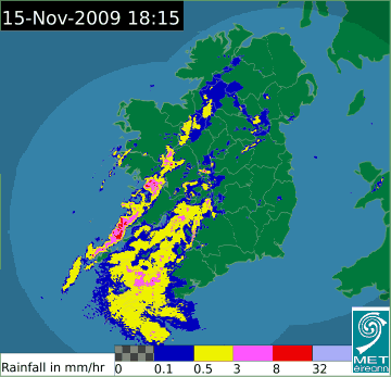
Torrential rain here in Galway and the radar looks frightning with whats coming, I listened to the news at six as well and the weatherman said a line of thunderstorms was moving along the West Coast, no lightning or thunder here, anyone have thunderstorms surprising we have nothing with this rain.
Question for MT: Why do we get so few Thunderstorms here in the West despite sometimes having the worst of the weather.
Radar Link: http://www.met.ie/latest/rainfall_radar.asp0 -
Monday, 16 November, 2009
__________________________
New moon occurs today at 1915 GMT.
TODAY will see further periods of rain in central and northern counties, with a few more showers to come in the south, but the intensity of this current system peaked around 0400h and seems to be a little on the wane now. Assuming you've had 20-25 mms of rain, expect another 5-10 mms before the rain tapers off to showers. Some clearing will develop across the south where winds have turned more westerly in direction. A few moderate gusts will continue on the east coast from the SE, then S and later WSW, but strong winds should be confined to higher hills and very exposed coasts. Highs today may reach 13 C in the south but more like 10-11 C in Ulster as the rain continues longer.
TONIGHT will see a fairly even mixture of cloud and clear skies, and one or two lingering showers, with moderate westerly breezes rather dying out inland to allow for some light and patchy ground frost in a few places. Lows will probably average 2-5 C with some higher and lower readings possible.
TUESDAY will feel a little cooler as a small insertion of Greenland-origin air mixes into the westerly flow, but this will also have the effect of clearing the skies to some extent and giving a few hours of sunshine to many parts. Lines of rather narrow and briefly intense hail showers can be expected over parts of Connacht in a moderate WNW wind (25-40 mph), and these will be dying out further east as sprinkles of rain. Some snow could be spotted on the highest hills in Mayo and Donegal, but highs down lower where most people spend their time will be 10 C or so.
TUESDAY NIGHT will see increasing cloud, strong southerly winds developing, and rain moving in around midnight, with lows early on near 5 C, but rising temperatures towards dawn.
WEDNESDAY will become quite windy and mild with periods of rain, hill fog and widespread mist, although the southeast could also have a few intervals of hazy sunshine. With SSW winds of 30-50 mph, the highs of 13-14 C may feel a bit lower perhaps.
THURSDAY will become even windier and extremely mild with periods of rain or heavy showers, some thundery. Winds will rise to about SSW 50-75 mph in exposed west and south coastal locations, and 35-55 mph more generally. After very mild morning lows of 10-12 C expect highs to touch 17 C in some parts, and certainly 15 C in many places.
THURSDAY NIGHT will continue very windy with squally showers and winds veering more to SW with speeds reducing to 25-45 mph and lows of 8-10 C.
FRIDAY will be a more variable day with more showers possible, still quite windy conditions (WSW 30-50 mph) and perhaps a few sunny breaks as well; highs of about 14 C will continue the unseasonable warmth.
THE CURRENT WEEKEND OUTLOOK is stormy ... I'm sure this question will loom large in all forecasts as we try to get clarity on a second round of very strong winds, but as the first round needs to come and go as predicted for this second round to set up, I'll just assign it a better than average probability of coming together as a 40-60 mph event and throw in the upper limit of 60-90 mph to keep in the back of one's mind for now ... the atmosphere has a way of reloading these strong wind events for many cycles before moving on to select a new target, and the jet stream has fallen in love with Ireland for better or for worse. This weekend storm would be on the mild side (12-14 C) with south to southwest gales or storm force winds according to the current guidance, peaking Saturday night, but this is five days out, and the last time we talked of this time frame, the storm slipped south of Ireland in the final analysis. I don't see as much potential for that here, given the fairly certain nature of the mid-week warm spell and wind event.
The following week looks like a gradual cooling trend in mostly westerly winds with occasional rather windy periods separated by less stormy times and so a fairly even mixture of cloud, sun and showers could be expected with that as temperatures fall back to more seasonable late November readings (like 8-10 C in the daytime and 0-3 C at night).
As I mentioned, we've been experiencing mild weather and continual rain although not all that heavy here. It looks like it could get heavier tomorrow as the gradient tightens further (to SSW 35-55 mph) ... seems like we are in a fairly similar kettle of fish, so to speak.0 -
M.T. Cranium wrote: »THE CURRENT WEEKEND OUTLOOK is stormy ... I'm sure this question will loom large in all forecasts as we try to get clarity on a second round of very strong winds, but as the first round needs to come and go as predicted for this second round to set up, I'll just assign it a better than average probability of coming together as a 40-60 mph event and throw in the upper limit of 60-90 mph to keep in the back of one's mind for now ...
Thanks for another well put together forecast MT. Your so right about these atlantic depressions. Very hard to pin down details until they get to about T36, and even then a slight deviation from the forecast can cause big changes further down the line. We can put last weeks storm just missing us down to the luck of the Irish, but odds are that our luck won't last, and could well run out pretty soon.and the jet stream has fallen in love with Ireland for better or for worse.
Ha, yes. Love in the wrong sense of the word. We are being stalked !! 0 -
I have just been reviewing the 06z GFS run, which depicts an intense windstorm for western Ireland (all of Ireland really, but the west coast would be absolutely raked over by this on Saturday if it verified) ... potential for 100 mph gusts with this version of the storm ... from now until then, about the same sequence as in my earlier forecast, but the Saturday event has been turbo-charged, with isobars packed very very tightly.
In other words, let's hope it's your typical GFS five-day wonder that turns into a three-day downgrade followed by a two-day complete miss ... but the thing looks disturbingly credible given the warmth predicted for most of the week and the prior set-up of a gale force southerly gradient.
Meanwhile, the reason I even saw this in real time is that howling winds outside my forest hut here in Narnia by the sea have kept me awake wondering about the future life span of my roof. We have a southerly gale howling away at about 60-70 mph in gusts that last about a minute, then it drops to 30-40 for a while and reloads. Too windy for rain but there is heavy rain on the radar a few miles west of here. The poor manager of this building where I live is going to be doing his work all over again later on, as all the neat piles of leaves are gradually returning to whence they came. With any luck they will continue on to the next property, I suppose.
Such is life as our two oceans compete for the top prize in foul weather production. :cool:
I hope to have better news about Saturday when I return this evening your time.0 -
Thanks for the updates MT. Hope your roof stays on!0
-
Thanks for the update MT and keep safe there, did you catch any good fish??
looking forward to your update this evening as I am in Galway and if it happens from the South or South West on Saturday then Galway would be in for some serious flooding from the sea.0 -
I have to fly from Kerry airport to Dublin early on Thursday Morning &
and then from Dublin to the Continent - could these trips considered as safe journeys taking the high winds in account?
Beer Drinkers support Farmers!
Abolish infamous Minimum Unit Pricing!
0 -
I have to fly from Kerry airport to Dublin early on Thursday Morning &
and then from Dublin to the Continent - could these trips considered as safe journeys taking the high winds in account?
Well in my opinion you should be fine.
i've the turbulence charts for europe up to wednesday at the moment with all of ireland and england suffering moderate turbulence at lower levels.you can check this site youself before you go.
http://131.54.120.150/index.cfm
all links on left to airport warnings,flight hazards etc
 0
0 -
I have to fly from Kerry airport to Dublin early on Thursday Morning &
and then from Dublin to the Continent - could these trips considered as safe journeys taking the high winds in account?
By the time Thursday comes round it could be stronger or weaker, at the moment I wouldn't be too worried. Check back again Wednesday.0 -
Advertisement
-
UPDATE _ Monday, 2050h
____________________
Just some odds and ends here ... the Thursday wind potential seems to be slightly downgraded in recent model runs, so with that in mind, the flights should be okay, assuming the first leg is not affected by anything local in scale.
Storm10 (I think) was asking about the scarcity of thunder in the west; this is the same for us near the west coast, lots of active weather, almost none of it thundery (3-5 days a year on average). I believe it is caused by the strong negative ionization of marine air masses, whereas thunderstorms develop along frontal boundaries where air masses have a positive charge often, ahead of cold or occluded fronts. This sets up the required electronic charge differential between clouds or between cloud and ground. So the lack of thunder can be ascribed to the same cause as the good psychological ambience of the seaside (the negative ions in the air make people buoyant and happy, some professional sports teams have even used ion generators to stimulate their players).
Conversely, a positively charged atmosphere makes people irritable, jumpy or even depressed. There is literature to show that the foehn or chinook winds are associated with elevated rates of violence and suicide. As we all know, people don't fight in seaside towns, they party.")
However, if the wind swings into the east and fronts develop, then a west coast location can experience the right atmospheric conditions for thunder.
A few really strong maritime fronts can overcome this barrier and you often see a lot of lightning over shorelines near hot, dry climate zones due to the outflow of those air masses running up against the marine air masses out to sea (as in southern Biscay, for example).
Now, the really big question is Saturday, and I don't know the answer (or even think I do) yet. It's beginning to look like a storm of some kind is likely; there are some signs that the track will shift a bit further east but I don't get the feeling that the track is going to go as far south and east as last weekend's low eventually did. Perhaps the current 12z GFS is not far from the right solution. Another model (GEM) shows a similar storm coming in later, around 0300-0600 Sunday, so keep that in mind too.
My weather continues wet and windy but those really strong winds subsided some time after 0430 when I finally managed to fall asleep; by 0830 they had gone to a more sedate 30-40 mph. Not much damage reported on the news, so I would have to think the winds peaked right around here as I saw a few full branches on the ground nearby this morning. Roof's still on (I think, it's three floors above my ceiling).
I shall try to update again around midnight perhaps.0 -
Thanks MT for the reply to my query, you are correct with the Easterly wind as I recall most big thunderstorms we have had moved from East to West. Also when a storm in the winter like now goes through I notice a lot of blue lightning as the end of the storm passes, very little thunder, does that make sense to you????0
-
Not sure what you mean by blue lightning, can you describe?
Meanwhile the latest storm watch adjustment is towards the wait and see position, as the 18z GFS chops up the weekend storm into several meaty bits and pieces. Not really convinced any model has a handle on this situation yet.0 -
M.T. Cranium wrote: »Not sure what you mean by blue lightning, can you describe?
Meanwhile the latest storm watch adjustment is towards the wait and see position, as the 18z GFS chops up the weekend storm into several meaty bits and pieces. Not really convinced any model has a handle on this situation yet.
Blue lightning I witness quite regularly here in the west in winter, particularly during unstable polar maritime airflows behind an active cold front. Red lightning to, which seems to be more a January thing.
I read somewhere before that blue lightning is usually the result of wind and hail but that sounds a bit daft.
Over to those in the know....0 -
Thanks MT for the reply to my query, you are correct with the Easterly wind as I recall most big thunderstorms we have had moved from East to West. Also when a storm in the winter like now goes through I notice a lot of blue lightning as the end of the storm passes, very little thunder, does that make sense to you????
Something like a blue jet? 0
0 -
Deep Easterly wrote: »Blue lightning I witness quite regularly here in the west in winter, particularly during unstable polar maritime airflows behind an active cold front. Red lightning to, which seems to be more a January thing.
I read somewhere before that blue lightning is usually the result of wind and hail but that sounds a bit daft.
Over to those in the know....
Thanks Deep Easterly I notice this blue lightning especially in winter and always seems to be at the end of the storm or when we get hail with squally winds and its always sheet lightning not always followed by thunder.
Thanks maquiladora for the very detailed chart for the lightning0 -
Advertisement
-
Thanks Deep Easterly I notice this blue lightning especially in winter and always seems to be at the end of the storm or when we get hail with squally winds and its always sheet lightning not always followed by thunder.
Thanks maquiladora for the very detailed chart for the lightning
Very same S10. Blue lightning always seems to accompany gale to storm force winds when the main front has passed over, often with no thunder. I often thought that friction against wind and ground/sea some times caused this phenomena, giving of a "static" blast. Probably a stupid theory though. 0
0 -
Thanks MT for the reply to my query, you are correct with the Easterly wind as I recall most big thunderstorms we have had moved from East to West. Also when a storm in the winter like now goes through I notice a lot of blue lightning as the end of the storm passes, very little thunder, does that make sense to you????
I experienced the most severe lightning storm here in the East in 1999 but there was no thunder at all. It was just constant overhead flashes. I found the experience completely bizarre. But in fact these are very high intra cloud strikes that happen very frequently in Summer temperatures. The strikes are so high that no thunder is recorded to the ear. Sound travels slower then light but no sound could be heard. Basically the lightning, whilst spectacular when happening - it is at a height that thunder won't be heard at ground level. You can hear a distant rumble - yes. But no constant rumble. And certainly, despite the light show, not very loud.0 -
Interesting stuff -- considering that I have probably seen many more thunderstorms (living for 40 years in the Great Lakes region) than most here, I must admit that I have never seen an unusual coloration of lightning. Sometimes the sky optical effects are different, but I'm sure you're describing some real differences in the colour of the actual lightning.
One type of lightning that may explain some of the phenomena you all describe would be what I know as "sheet lightning" -- this is an illumination of some higher level of cloud from distant lightning which would explain the lack of thunder. I've seen that kind of lightning on many summer nights in Ontario, and it can be from storms 50-100 miles distant.
I've also seen continuous lightning from a tornadic storm at 0300 hours local time, and I hope never to see that again because the storm that broke out was somewhere between awe-inspiring and fearsome. We narrowly missed a direct hit from an F-2 tornado in that storm (it's part of a documented event, the July 14-15 overnight "derecho" in the Great Lakes region). As it turned out, we were living right under the track of its most intense cell.
Sometimes lightning in hot, dry weather on the west coast here has an orange tint but I have always associated that with dust suspended in the air in almost-dry or dry thunderstorm cells.
Well enough about that for now, it's on to the forecast ...
Tuesday, 17 November, 2009
____________________________
TODAY will be rather unsettled in western counties, but will start dry in many parts of the east with some morning sunny intervals. As the day progresses, some heavier showers will develop in western and central counties, and some sleet or snow could fall on peaks in Connacht, with hail possible at lower elevations. Rainfalls of 10-15 mms may occur in places but the east will only see about 3-5 mms later on this afternoon. Highs will average about 10-11 C.
TONIGHT will have some clear intervals but strong southerly winds will develop around midnight and spread cloud and then rain into southern and western counties. Lows may occur before or around midnight (3-6 C) then temperatures could rise to near 10 C by sunrise.
WEDNESDAY will be moderately windy and quite mild with intervals of rain or drizzle, hill fog or mist, and winds SSW 30-50 mph, with highs near 14 C. Rainfalls of about 20-25 mms will be fairly widespread by Wednesday night.
THURSDAY will be very windy at times (S 45-70 mph) with some occasional rain or drizzle at times but a risk of heavier showers developing, and further rainfalls of 10-25 mms. Some places are bound to see resumed flooding from all this rain. The lows near 12 C and highs near 17 C may set some records too.
FRIDAY will see the very strong winds abating somewhat during the early morning as they veer more to the SW or even W (20-40 mph) with some clear intervals but also more light rain or drizzle redeveloping at times. The day will bring variable skies and some additional showery rain with winds backing slowly to the south again, and highs near 15 C.
(There is certainly a risk of an unseasonable "second spring blooming" episode for some plants in all of this warm, muggy weather).
THE WEEKEND is not set in stone by any means, as various models struggle with the details, but it certainly looks windy at times. One scenario would be a strong low rushing through the southeast and Irish Sea on Saturday morning, to be followed by a second strong low further north on Sunday. That would create a scenario of rain followed by gusty winds and showers for most of the weekend. Another plausible scenario remains the one major windstorm for part or all of Ireland. I am inclined towards the first of the two choices but I'm far from certain about it.
What does seem apparent is that considerably colder air will try to join in the circulation by late Sunday or Monday, but will be quickly absorbed into the relentless SW flow, so any briefly colder weather would be short-lived.
Around where I live, we are dealing with a rainstorm now after the earlier strong winds, but it's still quite gusty and very mild (14 C) at 10:50 p.m., and a strong front is approaching -- I may be reporting some more storm force gusts around noon your time and 0400 here as this pushes through the west coast (currently it is 300 miles west of here but winds are slowly increasing from the SSE ahead of the front).
It continues very mild to warm in eastern parts of Canada and the USA, highs of near 75 F have been recorded in places around Washington DC and south, and close to 70 F in NYC, more like 60 in Boston.
If you recall the brief career of "Ida" the remnants of that were absorbed yesterday into the low that is approaching the central Atlantic now, so in a roundabout sort of way, the strong winds you'll see on Thursday will be associated with remnants of Ida.0 -
I've posted some weather pictures recently, the links for which are up at the top of this weather forum page.
Meanwhile, this is where we really like to visit when we get the chance, the heavy snow is pretty much guaranteed here in the mountains of eastern British Columbia (this is the small town of New Denver, BC, which is on a glacial lake about the size of the larger lakes in Ireland).0 -
Great to see the pictures. Thanks for the updates and the pics 0
-
Advertisement


Advertisement