Advertisement
If you have a new account but are having problems posting or verifying your account, please email us on hello@boards.ie for help. Thanks :)
Hello all! Please ensure that you are posting a new thread or question in the appropriate forum. The Feedback forum is overwhelmed with questions that are having to be moved elsewhere. If you need help to verify your account contact hello@boards.ie
Hi all! We have been experiencing an issue on site where threads have been missing the latest postings. The platform host Vanilla are working on this issue. A workaround that has been used by some is to navigate back from 1 to 10+ pages to re-sync the thread and this will then show the latest posts. Thanks, Mike.
Hi there,
There is an issue with role permissions that is being worked on at the moment.
If you are having trouble with access or permissions on regional forums please post here to get access: https://www.boards.ie/discussion/2058365403/you-do-not-have-permission-for-that#latest
There is an issue with role permissions that is being worked on at the moment.
If you are having trouble with access or permissions on regional forums please post here to get access: https://www.boards.ie/discussion/2058365403/you-do-not-have-permission-for-that#latest
The Sudden Stratospheric Warming 2011/2012
-
01-11-2011 9:39pm#1Here we go again.
This is my third season and I think all of us have learned more each time.
Some links
http://www.inscc.utah.edu/~reichler/research/projects/TS/TS.shtml
http://www.cpc.ncep.noaa.gov/products/stratosphere/strat-trop/
http://www.geo.fu-berlin.de/en/met/ag/strat/produkte/winterdiagnostics/index.html
http://ds.data.jma.go.jp/tcc/tcc/products/clisys/STRAT/
Link to a previous thread that give loads of info
http://www.boards.ie/vbulletin/showthread.php?t=2055728070
I've a good feeling this time round that we will see a Strat Warming which will promote height rises to our North, giving a negative Arctic Oscillation and thus helping to create a major wintry outbreak.
Now whether that happens at all is another thing but we are seeing a negative QBO high up and in the New Year these should have transferred lower to help decrease the strength of the Polar Vortex.
Major winter stratospheric warmings preferentially occur during the easterly phase of the QBO, Holton and Tan (1980).
Easterly QBO high over equator (BLUE-Mean Easterly winds)
Jet Stream around 40n-50n
In the below image im looking to seeing any warming anomaly taking place.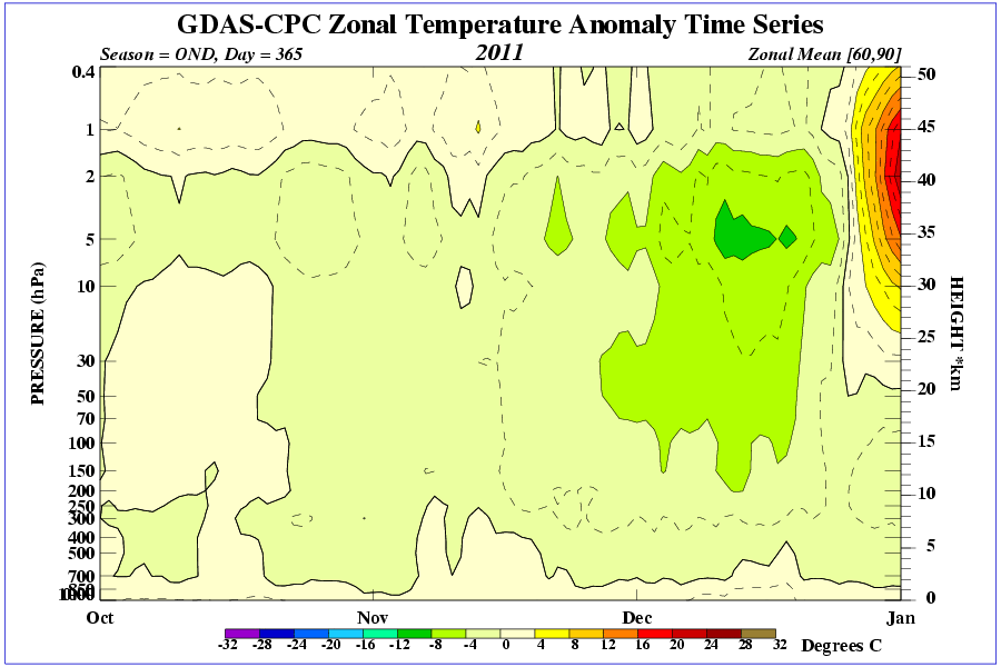
And Current condition at 30mb over the pole.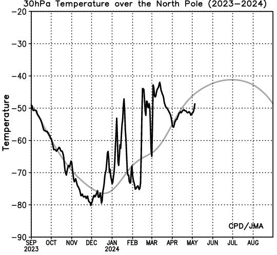
All input welcome.10
Comments
-
Despite having followed this before both here and netweather, i can't remember a single thing about it! Time to start reading up again I think!0
-
I've done a bit of reading on it over the past week since the netweather thread started up, there's a good explanation of it here
http://forum.netweather.tv/topic/71340-stratosphere-temperature-watch-20112012/0 -
That went completely over my head.
So a sudden warming is good or bad sign for the winter.
For reference
good = cold and snow
Bad = mild and wet 0
0 -
That went completely over my head.
So a sudden warming is good or bad sign for the winter.
For reference
good = cold and snow
Bad = mild and wet
Stratospheric warmings: Meteorologists identify cause of cold and warm periods during winter
ScienceDaily (2011) — Meteorologists at Freie Universität have found a correlation between warming in the stratosphere and cold or warm winter periods. They observed that there is an increased number of stratospheric warmings, when the heat flow from the North Atlantic into the atmosphere is increased. Trends for winter temperatures can be derived from these new findings.
“This could mean that in Europe there will increasingly be periods lasting several decades with predominantly colder winters alternating with periods of warmer winters,” says Semjon Schimanke, who led the research, reported in the journal Geophysical Research Letters. The meteorologists expect that in the long term their research will help weather forecasters make more accurate predictions.
The phenomenon of stratospheric warming was first discovered in 1952 by Professor Richard Scherhag at the Institute of Meteorology, Freie Universität Berlin. It appeared in the scientific literature as the “Berlin phenomenon.” In the meantime, these events are referred to as “sudden stratospheric warmings,” and 30 have been registered so far.
On average, sudden stratospheric warmings occur in every second winter, and they are very unevenly distributed over the observation period. Only a single stratospheric warming occurred between the winters of 1988/1989 and 1997/1998, while nine have been registered since the beginning of this millennium. So far there has been no explanation. With their new research, the meteorologists at Freie Universität have shown that the intermittent sudden stratospheric warmings are a consequence of the interaction between the North Atlantic, the troposphere, and the stratosphere. They found that an increased number of sudden stratospheric warmings occur when the heat flux from the North Atlantic into the atmosphere is increased.
During the winter months in the lower polar stratosphere, which lies approximately 20 kilometers above the Earth’s surface, temperatures on average are below minus 70 degrees Celsius. The cold temperatures are combined with strong westerly winds that form the southern boundary of the so-called stratospheric polar vortex. This dominant structure is disrupted in some winters or even reversed. Under these conditions the temperatures in the lower stratosphere rise within a few days by more than 50 degrees, and the polar region is warmer than southerly latitudes. This implies a reversal in the west-east winds and the collapse of the polar vortex. Using models and observations, it was possible to show that such sudden stratospheric warmings are initially excited from the troposphere, but then also have a strong influence on tropospheric circulation.
After a sudden stratospheric warming, among other things the differences in pressure between the Icelandic Low and the Azores High are reduced. This pressure difference determines the prevailing wind direction for Central Europe and thus determines whether the European winter turns cold or warm. Thus, for example, the 2009/2010 winter was characterized by a highly disturbed polar vortex, and in many parts of the Northern Hemisphere there was a severe and snowy winter.0 -
-
Advertisement
-
I've circled on below chart the Polar Vortex at the end of Jan 09 during the Major Strat Warming which tore the PV to shreds and reversed the normally strong westerly winds to easterly.This gave us the cold weather soon after.
The Arctic Oscillation had to drop.
And so the end result the negative (COOL) phase and great chance of being cold and snowy.0 -
Nothing too exciting to report as of yet.
I'll also just pop on here the Zonal winds graphs. 0
0 -
Started reading the given links.
I've a splitting headache.
I have to lie down.0 -
-
On the above image, The high pressure over the arctic, Is this the high pressure we look to build over greenland? Or is it something completely different?
I'm going to read the links later when i have the chance.
Here ya go,
Firstly show positive AO conditions so low heights over high latitudes and a strong Polar Vortex,as in westerlies dominant.
Next up the opposite and the crème de la crème for cold lovers,
Negative AO and weak Polar Vortex.
This is why we like to monitor the Stratosphere as warmings can disrupt the normal strong westerly Polar Vortex and potentially reversing them.
This all can contribute to Negative AO conditions.
Hope this makes more sense to people.
Images are from this site.Have a look as it also explains the NAO.Tis very well put together.
http://www.nc-climate.ncsu.edu/climate/patterns/NAO.html0 -
Advertisement
-
A simple way to look at all this strat warming is a bucket of water.
You have a bucket of water. The water represents the atmosphere, and the centre of the bottom of the bucket, the North Pole. Set the water stirring in an anticlockwise direction. A depression will form in the centre of the surface of the water, while the water rises slightly up the side of the bucket. This simulates the polar vortex. The low height of the water in the middle of the bucket represents the low heights in the cold winter airmass over the Pole. Heights rise around the sides, like heights rise as we head to lower latitudes. This is what drives the strong westerly winds.
Now imagine if you stick your hand into the water, near the edge of the bucket. Watch the flow of the water. As it reaches your hand, it will deflect inwards towards the centre, then swing around to flow in the opposite direction behind your hand. This is what happens in stratospheric warming. A disturbance from low down in the troposphere interrupts the westerly flow in the stratosphere, with temperatures and hence heights rising as a consequence. This causes the flow to become broken down, and even reversing to from an easterly direction. This can cause a so-called split vortex, and after a week or so, the easterly winds can migrate downwards into the troposphere. This is usually where our coldest airmasses come from, so it is nice to watch for the these strat warming events, which normally come around every one to two years. If we see a decent one forming, there is a chance that we could see some blocking forming aa week or two down the road.0 -
Movin' on up!......finally!
 0
0 -
-
Joe Bastardi says,
Stratwarm event starting in Siberia in about 10 days similar to set up for 1984-1985 winter
Now i was curious to i checked up for us boardsies at what the 500mb Geopotential Heights were for the month of Jan of 1985,And simply smiled when i saw
THIS0 -
0
-
-
Hmm I lived in on the East Coast during these winters. Great snow. Loads of time off school.
But I now Live in the West (East of Galway) so what was the snow like during 84-85?0 -
I must admit I'm still slightly confused but thanks Su for explaining in basic terms for us physics challenged people

Red was the last chart you posted from 84/85 if so how is the same chart looking today? Also I'm pretty colour blind (a major bummer when trying to chart read) so if you or anyone else for that matter could stick in a brief description/comparison of the 84/85 chart and the one now it would be much appreciated 0
0 -
All about Jan/Feb 1985
http://www.ukweatherworld.co.uk/forum/index.php?/topic/49683-
As for the colour blindness,sorry mate.So i direct you back to the previous post 11 with labels on Northern Hem chart about height rises and a weakened Polar Vortex.Click on link provided,gives great info.0 -
All about Jan/Feb 1985
http://www.ukweatherworld.co.uk/forum/index.php?/topic/49683-
As for the colour blindness,sorry mate.So i direct you back to the previous post 11 with labels on Northern Hem chart about height rises and a weakened Polar Vortex.Click on link provided,gives great info.
just what i wanted, ta very much0 -
Advertisement
-
From a poster over on netweather:
The GFS is forecasting a far stronger warming that is showing signs of propagating to lower levels. I think that this is being reinforced by another bout of strong wave activity breaking into the stratosphere. The ECM has a really strong warmining at 1hPa that i9s forecast to diminish rapidly at T+ 192 after breaking through the surf zone. I think that this could because the warming is propagating further down the vortex - but that this has yet to show up significantly on the ECM charts yet.
http://wekuw.met.fu-...ast=all&lng=eng
However at T+240 on the GFS at 30 hPa we see this:
This is very encouraging indeed and will start to have an effect on the vortex come the new year even without an SSW.
Very, very promising indeed.0 -
Yea agree with what Nacho posted, just noticed this forcasted warming a few minutes ago-

This shows a warming at the 30hpa level at 90N, Data from the ECM by the way!
Great news!

Dan :cool:0 -
Join Date:Posts: 6780
Taken from NW :
For the first time this winter we are about to see the stratosphere taking a big hit with remote wave breaking over the top of the stratosphere. It would be interesting to see the latest MT readings. Are we seeing a resurgent MT event deflecting these wave?
Here is the momentum flux forecast for both waves - very strong activity seen here propagating into the mid stratosphere.
So how does this effect the polar vortex? Well the wave introduces warmer air into the vortex. The edge of the vortex is known as the surf zone and to cause maximum disruption we would like to see the warmer penetrate this strong barrier. And when we look at the 1 hPa chart right at the top of the stratosphere we see exactly that occuring.
This is important because getting the warm air right inside the vortex will squeeze the colder air out, mix and cause a reduction of the vortex strength. However this is right at the top of the stratsophere and to benefit tropospherically from this we need to see the same ocuring at lower levels. Today at the 30 hPa we are seeing signs that this is occurring.
Now this presently is not enough to cause a SSW - we would need to see far greater warming for this ( but can't rule out that happening from this wave either). But it is enough to cause a displacement of the vortex.
And if this forecast comes to fruition then we will have far more to look forward to coming into the new year as further waves feed back into the stratosphere. With a reduction of the vortex for the first time this winter the door would be opening for northern blocking to occur.0 -
Join Date:Posts: 6780
nacho libre wrote: »From a poster over on netweather:
The GFS is forecasting a far stronger warming that is showing signs of propagating to lower levels. I think that this is being reinforced by another bout of strong wave activity breaking into the stratosphere. The ECM has a really strong warmining at 1hPa that i9s forecast to diminish rapidly at T+ 192 after breaking through the surf zone. I think that this could because the warming is propagating further down the vortex - but that this has yet to show up significantly on the ECM charts yet.
http://wekuw.met.fu-...ast=all&lng=eng
However at T+240 on the GFS at 30 hPa we see this:
This is very encouraging indeed and will start to have an effect on the vortex come the new year even without an SSW.
Very, very promising indeed.
And he seems to be very happy with again today also .
Good GFS as well today.
I love the shape of the warming seen at the 10 hPa level.Here is the 30 hpa level for T+240
And distortion of the vortex starting - we will need a greater warming than this to give a SSW .0 -
As long as were heading in the right direction I'm happy.0
-
-
I've picked out 2 examples looking at the table.nacho libre wrote: »
Here's the Dec 84 Pacific blocking prior to the split PV in Jan 85
Pacific/Atlantic blocking prior to 1963 split PV 0
0 -
whats east of us now is pretty warm
7c in romania and poland.
Only around zero in moscow.
No building blocks visible to even hint at december 10 cold.
What red sunset has pointed out are 2 random years.Thats only saying somethings possible but then the same could be said for roaring southwesterlies if you examine winters they've happened.
It means nothing unfortunately forecast wise without building blocks.0 -
Just to clarify i wasn't forecasting anything,just simply showing for my own and others interest what the Northern Hemisphere blocking looked like prior to some major cold outbreaks as highlighted in the PDF as to the precursor to Polar Vortex splitting events.Is that Ok, Black Briar. Not giving anyone false hopes here.
Yes conditions to the immediate east are fairly sh1te at the moment,past that and there's the tap so everywhere to our east will have to cool down immensely first to get the holy grail. 0
0 -
Advertisement
-
if there is a change in the nh pattern that leads to blocking, i wouldn't get caught up in how warm it is now further east in comparison to normal, it would obviously take that bit longer to cool down, but cool down it would. Let's worry about getting the right parameters in place first.
also bear in mind:. From January 22nd to March 17th 1947, snow fell every day, somewhere in the UK! So we've plenty of time for it to get colder.0 -
Winter-11-12-arctic-oscillation
by TQ from newxsfc
The Arctic Oscillation (AO) has been positive 99 out of 108 days since 01 SEPT however...there are a few signs suggesting a change for the better may be afoot.
The first sign points to a weakening polar vortex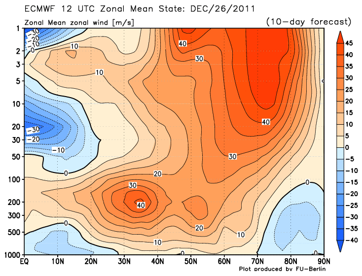
The wind speeds are currently running ~100 kt in the last few millibars @40°;N and are forecast to weaken to ~45 kts at D+10. Also note the development of deep easterly flow below 100 mb suggesting the presence of a hi-latitude anticyclone and an strengthening sub-tropical jet. A hi-latitude HIGH would flip the sign of the AO to negative.
The second sign points to a warming stratosphere over the 90°N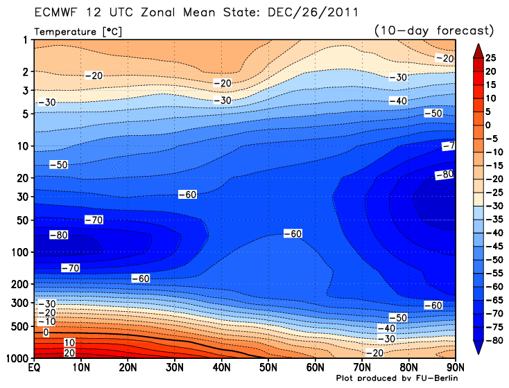
If the warming persists and works its way down...this would build and anti-cyclone aloft which could propagate toward the surface and create of re-enforce a negative AO.
The last sign points toward a bloated chunk of cold air from Siberia migrating into eastern North America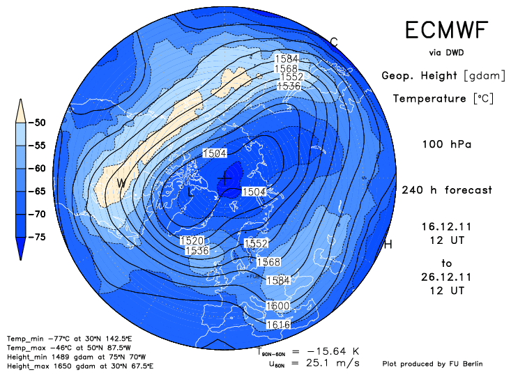
Note the 'W' in the light orange area. This frigid feature propagated east from Siberia. It indicates a warm stratosphere and low geo-potential heights in the troposphere.
The state of the AO through the years (1950 - 2011) at fifteen days into the meteorological winter 0
0 -
Just wondering what a stratospheric warming event is? Mt used the words in his forecast this morning. Apologies if it has already been discussed0
-
-
We really need to see warming at the 30hpa level of the Stratosphere to increase the chance of warming affecting the Troposphere. At the current level it may not be enough to percolate down to affect it.
What we're currently getting is a downwelling event caused by something known as rossby waves. A SSW seems to occurs from upwelling - this is an event- usually Trophosphoric blocking - in the troposphere causing the Stratosphere to warm up. These happen quickly and the effects are quicker.
The questions to be resolved are: can this downwelling in turn cause an upwelling event? or will the downwelling be sufficient in itself to change the current NH pattern? if so it will probably take longer for us to see the effects...
a real cause for concern is that in the past two years the ECM extended range output correctly flagged the northern blocking, however
the ECM longer range output shows no sign of northern blocking even through January and beyond. we must hope that they've overlooked something this time.0 -
Hello.
I have just registered on the forum, but I am reading this topic for a while now. I would really like to thank you all for this great topic, which is very educational. I am familiar with classic meteorology, but the "Upper meteorology" is relatively new to me.
I haven't read all the links about the SSW in the first post, since my job is kinda limiting my free time for meteorology, but I am making slow progress.
Now, down to business:
I can say, that even with my little knowledge about SSW, I can spot the signals in models, when I see them. Or that's just me.
I was kinda surprised by the ECM 20.12 12z run.
Here are some graphics, that clearly speak for themselves.
Current status @30hpa
The 10-day forecasts are very interesting. At least for me.


Things are on the move, as I see them. Maybe I am not looking wide enough, but I think that this certainly is worth monitoring.
I apologise if I have posted too many graphics.
Looking forward to hear some thoughts from you, about this latest forecasts.
Best regards,
Andrew.
P.s.: I live in Slovenia, Central Europe, so maybe my time for posting will be a bit different that many of yours. And I apologise for the spelling, since English is not my mother language. 0
0 -
Advertisement
-
Welcome, Andrew. Yes I find the subject fascinating myself and things are heating up, lol. Look to be serious Polar Vortex disruption at the top level (1hpa) as the warming penetrates into the core of the vortex. Winds are forecast to turn easterly up there as a result and look as though they will propagate somewhat, as can be seen in forecasted warming in levels below that. Question is, will it be enough to cause a SSW. Well it's certainly a start.

 0
0 -
Great posts guys. Makes for interesting reading while the weather we are currently having is about as boring and uninteresting as possible for this time of year.0
-
Looking promising...touch wood.
 0
0 -
-
-
Advertisement
-
-
Hi Su, in layman's terms what is this telling us?
D
Watching the evolution of that pattern, the polar vortex (blue) is becoming overwhelmed by the warmer temperatures, which is setting up and easterly flow between the two over Greenland and northern Canada. This process looks like possibly continuing as far as splitting the whole pattern in a figure-of-eight, with two distinct curculations - one cyclonic and another anticyclonic. This can set up blocking in the lower atmosphere later on, which could bring us an easterly or northeasterly. It all depends on where the blocking high sets up camp.
As this is the far reaches of the GFS it could all go belly up, but is just a promising sign if you like cold in January (which is around 99.999% of people here!).0 -
Thanks for the clarification Su

D0 -
Join Date:Posts: 6780
This mornings update - there is a lot to take in.
Firstly, we are about to see a large wave 1 induced warming that is going to disrupt the stratosphere for the first time this winter. We have been waiting a long time to see the below average cold conditions driving the strong polar vortex be threatened.
So this wave breaking into the upper stratosphere is large enough to give a forecast reversal of mean zonal mean winds at the upper levels of the stratosphere. The vortex though is not forecast to break up completely. It is close and probably on a knife edge, but I suspect that we will need another wave break and subsequent warming to break the vortex.
Moving down the warming does propagate down to the 10 hPa level and propagation is supported by a poleward EP flux. However it is insufficient to give us a SSW currently - so still no SSW.
However, what is forecast to occur is very encouraging and will have some effects on the vortex positioning in the troposphere. In fact I suspect that a Pacific based ridge will build which will be a preconditioning building block to an eventual SSW. We are most certainly heading in the right direction, but frustratingly for cold lovers more patience required.0 -
Join Date:Posts: 6780
Current Heat Flux
Projected
10hpa Height / Temps
Zonal Wind reversal0 -
I would just like to point out the CFS v.2, weekly forecast.
This if for week 3. An Atlantic and Pacific blocking. To me, this looks promising.
Best regards.0 -
Nothing much happening with the polar vortex for the next 10 days at least. Holding strong.
Analysis (00Z 29th December)
T+5 days
T+10 days
0 -
Interesting events to follow indeed.
I've been looking at University of Berlin data (http://wekuw.met.fu-berlin.de/~Aktuell/strat-www/wdiag/diag.php?alert=1&lng=eng) and though I kind of understand the first table (geopotentials and temperatures) I'm not sure about how to interpret the third table (zonal mean sections NH), especially heat flux and momentum flux. A tricky one too is the physical meaning of Eliassen-Palm-Vector.
Any pointer is very welcome.
Best wishes and Happy New Year,
Stephane0 -
I came across this from an Italian website so here it is translated,gives some good info in helping to understand. Excuse some sentences that are difficult to understand because of dodgy translation.
The QBO positive in conjunction with the low solar activity leads to a Stratospheric Polar Vortex ( VPS) is completely blocked, due to the semi-block full of "Brewer Dobson Circulation" that stratospheric level, is a real current hemispherical sundial can connect with the polar equatorial regions. In short, when the BDC is very weak, the VPS is very strong and cold as well as affected by stratospheric zonal wind very intense. Thus the entire structure of the polar vortex (VP) is very compact, with very few opportunities to exchange major meridians (Europe swept by the flow of warm ocean zonal matrix). In such a context, in fact, the large planetary waves, whose propagation is prerequisite for the cold air down from high to medium-low latitudes, enter into serious crisis. In other words, because of the high-speed stratospheric zonal, the heat flows from the array of tropical troposphere to the stratosphere polar penetrate up through the propagation of Rossby waves, are strongly divergent.
A similar situation is greatly aggravated by Nina moderate / strong central in nature. The strong trade winds, related to the Walker circulation that blow constantly on the ground over the years affected by the phenomenon of the Nina, potently inhibit the development of the Convention on much of the deep Pacific, being the largest ocean on the planet, turns out to be crucial for As regards the complaints against the VP. The reduction of air deep concern to the Convention has 2 effects:
1) further reduction of the strength of the BDC that much depends on the convective Pacific and in particular the amount of water vapor which, through the tropopause, the stratosphere Equatorial penetrate;
2) reduction of heat that flows from the troposphere into the stratosphere polar penetrate through the "breakthrough" in the layer of Rossby waves. Said terms "playful", the tropical heat of the Convention is a fuel for the formation of large, long waves can break into the stratosphere.
The situation described so far is "photographed" by some key images. First of all I report an image, captured by the satellite OMI-AURA, representing the amount of ozone in the polar stratosphere in early December. In this regard, remember that ozone transport from equatorial latitudes (where it originates) to the polar is related to the intensity of the BDC. Therefore the amount of ozone in the VPS is a good index to measure the strength of the BDC.
You can easily see the ozone hole just above the North Pole.
Secondly carry the image from ECMWF carriers on the EP-FLUX. In two words, remember that these vectors represent the amount of heat fluxes and momentum from the troposphere to penetrate the polar stratosphere. Therefore, the longer vectors indicate a good propagation and vertical flow of heat from the trope of the layer (good wave propagation).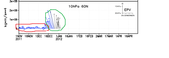
You will notice that until mid-December (red circle) patterns were completely different, a symptom of a VPS in great shape. Precisely in this period were reached in the polar stratosphere temperatures very low, near-record. In the second half of the month but something has changed since the first heat fluxes have been able to penetrate in part into the stratosphere (green circle). This forcing, started as told in the middle of the month and due in large part to the action of the continuous wave 1 (wave-Pacific), will in the coming days to less warming of the first season.
As I have repeatedly pointed out in comments made in the weather , the disorder is not at all associated with a dynamic thrust of the wave 1 (elevation of the Aleutian hp), but to a particular location of the lower middle VPS that has allowed the vortex semi-permanent Aleutian taking a particularly favorable position. Specifically, the continuing dynamic action induced by the tropo-wave 3 (Asian wave) led the Polar Vortex in the lower stratosphere, to assume a configuration with a major axis ellitticizzata highly favorable (Canada-Eastern Siberia). This location has enabled VPS elliptical same "catch air" right where you are in fact the only obvious sources of heat in the Pacific under the like Nina (+ SSTA in the western Pacific).
This trend is clearly perceptible even from paper to 500hPa (with which you certainly more familiar). In this regard, the red arrow represents the pressure exerted by the wave 3 resulting ellitticizzazione the VP (the axis of the ellipse is highlighted by orange arrow).
That dynamic has allowed, as mentioned, discrete inflow of heat by the wava 1 and the resulting first discrete stratospheric warming of the season, as well detectable by the following paper 10 hpa: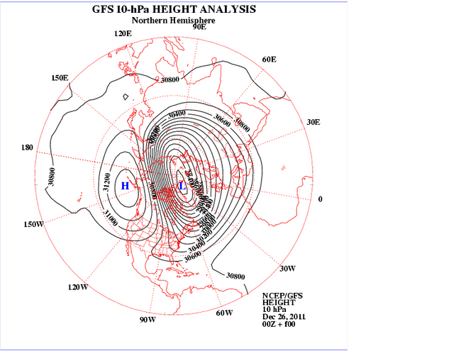
As mentioned repeatedly, the upcoming minor warming (however weak) will have major repercussions in the troposphere. The main effect will be to produce a rotation axis of the polar vortex with major redistribution of vorticity. In particular, the translation of warming from eastern Siberia to Canada will produce a major shift of vorticity of the VP to the Euro-Atlantic sector.
The figure shows the shift of warming on Canada resulting in migration of the centers of vorticity towards the European sector.
In this phase of migration of arctic masses there will be a weak recovery in wave 2 (wave-Atlantic), with the hp of the Azores which will be facilitated to gain ground toward higher latitudes temporarily. This ripple will produce later this year a rapid and very weak foray into the Arctic Mediterranean, whose implications do not seem yet to be fully framed by the models.
In the next phase (beginning of new year), the successful transition of the masses on the Arctic sector Euro Russian by the desplacement layer, an inevitable result of the strengthening of the polar jet over Europe, with a consequent increase in the zonal velocity. This phase will therefore very likely that your hp interference ocean on our country will therefore be affected by weather and mild temperatures for the period, especially during the day (in fact the strong temperature inversion, however, guarantee low temperatures at night, especially in areas internal and in the Po Valley). The persistence dell'anticiclone on Italy, however, should not be very durable. In fact, the propagation of the warming even at lower altitudes would produce a further lowering of the polar jet over western right, favoring the entry of our country short fronts the Atlantic / North Atlantic. It should still be a minor ripple, not able to make big jerks.
Meanwhile, because of the changed position of the VPS is expected to witness the interruption of the inflow of heat from the wave 1 and the upper stratospheric warming quotas should be gradually reabsorbed. Therefore, it should embody a kind of zero at the end of baric disturbances introduced by the previous situation of forcing.
So far the forecast should have a good chance of success. For the later can only make assumptions without much qualitative feedback especially temporally. However I will try to draw a trend line based on some considerations.
First of all is to include the imminent passage of the QBO at 50 hPa in negative territory, proven step by ECMWF forecasts on the trend of zonal wind:
From this paper shows clearly how in 10 days, the share of the equator and 50 hpa (red circle) is already on the QBO value neutral.
The passage of the QBO in the negative at this stage may not have large seasonal shocks as the consequent strengthening of the BDC will have no effects in the polar stratosphere immediately. In fact, the air particles that move from the equator to the poles through the BDC take between 3 to 4 months to get the pole. Therefore, the stratosphere will continue to be locked down. However there are other effects induced by the passage of the QBO negative, in this context, may still be interesting.
First, when the eastern tropical wind regime (QBO-), the tropical easterlies tend to restrict the width of the planetary wave -guides in the extratropical lower stratosphere, favoring a larger amplitude wave and a slower phase. Secondly, the QBO-is able to make an increase in convective activity in the Pacific, especially in areas already covered by the Convention Deep (western Pacific under Nina like). This phenomenon is more exasperated by the low solar activity.
For these reasons I expect that the next tropospheric forcing of the stratospheric polar damage can be more effective than the previous one and therefore is a good time that we are waiting for a long.
The dynamics of the disorder among other things could be quite similar to that which produced the first warming of the season, due to the reactivation of the Wave 3 (Wave Asian). In fact, the wave 3 receives heat (energy) from the Atlantic jet, which, as mentioned above, is expected to sharp increase from next week. Specifically, the intense Atlantic jet, not just cross the continent of Europe, tends to slow for thermodynamic reasons, accumulating a lot of heat in this area (Eurasia).
The pressure-induced reactivation of tropowave 3 ellitticcizzazione induce a new VP, resulting in recovery of heat flow by the wave 1 (EP-FLUX new convergent). At this stage, as indeed said, the amount of energy and heat may be much larger. The heat developed by the new layer for propagation may be more enhanced by the strong interest that the average zonal speed the lower stratosphere for a long time. In short I think there's a good chance of being able to attend a stratwarming respectable, which could have implications in the troposphere also remarkable.
With regard to the timing, you should go for long enough. Let's say that straddles the end of the beginning of January you could have the first three waves of reactivation. This activation may favor, together with the location of the VP ellitticcizata, the slowing of the jet over Europe, with resumption of the Atlantic wave 2 (omega shape of the VP). This could cause a first down on its own arctic continent of Europe. From this point on, would share the flow converged layer with stratospheric beginning of the new disorder, which could last several days. In the third week of the month it reached maturity stratwarming, with implications in the troposphere, which began to take place in late January / early February.
I repeat once again that this is a trend, especially as regards the timing. Therefore, the changes may be considerable. Moreover, the stratospheric forecasts still do not begin to frame any favorable situation. The season is not as we know the good ones and there are these "attacks" even the smallest clues favorable. And then as they say, hope is always the last to die.
INTEGRATION: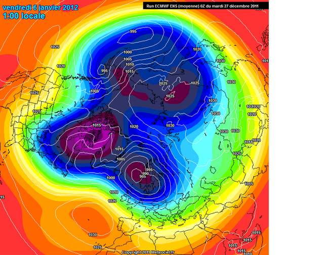
From this image taken from ECMWF ENSEMBLE this morning we see that the models begin to frame the dynamics described at the end of the article. In particular, it is clear the pressure wave induced by the trope of omega-3 resulting in the disposal of the VP. This particular configuration could lead to the end of the first decade of January (maybe later), a first foray into the Arctic on our country, whose trajectory and the consequent implications would obviously all be evaluated. The important thing, which seems to be reflected among others in different emissions modeling today, is that the VP seems to be brought back to ellitticcizzarsi, resulting in recovery of heat flows converging in the stratosphere by the peaceful wave 1. This is a prerequisite in view of the end of the month stratwarming suggested to me.0 -
I came across this from an Italian website so here it is translated,gives some good info in helping to understand. Excuse some sentences that are difficult to understand because of dodgy translation.
The QBO positive in conjunction with the low solar activity leads to a Stratospheric Polar Vortex ( VPS) is completely blocked, due to the semi-block full of "Brewer Dobson Circulation" that stratospheric level, is a real current hemispherical sundial can connect with the polar equatorial regions. In short, when the BDC is very weak, the VPS is very strong and cold as well as affected by stratospheric zonal wind very intense. Thus the entire structure of the polar vortex (VP) is very compact, with very few opportunities to exchange major meridians (Europe swept by the flow of warm ocean zonal matrix). In such a context, in fact, the large planetary waves, whose propagation is prerequisite for the cold air down from high to medium-low latitudes, enter into serious crisis. In other words, because of the high-speed stratospheric zonal, the heat flows from the array of tropical troposphere to the stratosphere polar penetrate up through the propagation of Rossby waves, are strongly divergent.
A similar situation is greatly aggravated by Nina moderate / strong central in nature. The strong trade winds, related to the Walker circulation that blow constantly on the ground over the years affected by the phenomenon of the Nina, potently inhibit the development of the Convention on much of the deep Pacific, being the largest ocean on the planet, turns out to be crucial for As regards the complaints against the VP. The reduction of air deep concern to the Convention has 2 effects:
1) further reduction of the strength of the BDC that much depends on the convective Pacific and in particular the amount of water vapor which, through the tropopause, the stratosphere Equatorial penetrate;
2) reduction of heat that flows from the troposphere into the stratosphere polar penetrate through the "breakthrough" in the layer of Rossby waves. Said terms "playful", the tropical heat of the Convention is a fuel for the formation of large, long waves can break into the stratosphere.
The situation described so far is "photographed" by some key images. First of all I report an image, captured by the satellite OMI-AURA, representing the amount of ozone in the polar stratosphere in early December. In this regard, remember that ozone transport from equatorial latitudes (where it originates) to the polar is related to the intensity of the BDC. Therefore the amount of ozone in the VPS is a good index to measure the strength of the BDC.
You can easily see the ozone hole just above the North Pole.
Secondly carry the image from ECMWF carriers on the EP-FLUX. In two words, remember that these vectors represent the amount of heat fluxes and momentum from the troposphere to penetrate the polar stratosphere. Therefore, the longer vectors indicate a good propagation and vertical flow of heat from the trope of the layer (good wave propagation).
You will notice that until mid-December (red circle) patterns were completely different, a symptom of a VPS in great shape. Precisely in this period were reached in the polar stratosphere temperatures very low, near-record. In the second half of the month but something has changed since the first heat fluxes have been able to penetrate in part into the stratosphere (green circle). This forcing, started as told in the middle of the month and due in large part to the action of the continuous wave 1 (wave-Pacific), will in the coming days to less warming of the first season.
As I have repeatedly pointed out in comments made in the weather , the disorder is not at all associated with a dynamic thrust of the wave 1 (elevation of the Aleutian hp), but to a particular location of the lower middle VPS that has allowed the vortex semi-permanent Aleutian taking a particularly favorable position. Specifically, the continuing dynamic action induced by the tropo-wave 3 (Asian wave) led the Polar Vortex in the lower stratosphere, to assume a configuration with a major axis ellitticizzata highly favorable (Canada-Eastern Siberia). This location has enabled VPS elliptical same "catch air" right where you are in fact the only obvious sources of heat in the Pacific under the like Nina (+ SSTA in the western Pacific).
This trend is clearly perceptible even from paper to 500hPa (with which you certainly more familiar). In this regard, the red arrow represents the pressure exerted by the wave 3 resulting ellitticizzazione the VP (the axis of the ellipse is highlighted by orange arrow).
That dynamic has allowed, as mentioned, discrete inflow of heat by the wava 1 and the resulting first discrete stratospheric warming of the season, as well detectable by the following paper 10 hpa:
As mentioned repeatedly, the upcoming minor warming (however weak) will have major repercussions in the troposphere. The main effect will be to produce a rotation axis of the polar vortex with major redistribution of vorticity. In particular, the translation of warming from eastern Siberia to Canada will produce a major shift of vorticity of the VP to the Euro-Atlantic sector.
The figure shows the shift of warming on Canada resulting in migration of the centers of vorticity towards the European sector.
In this phase of migration of arctic masses there will be a weak recovery in wave 2 (wave-Atlantic), with the hp of the Azores which will be facilitated to gain ground toward higher latitudes temporarily. This ripple will produce later this year a rapid and very weak foray into the Arctic Mediterranean, whose implications do not seem yet to be fully framed by the models.
In the next phase (beginning of new year), the successful transition of the masses on the Arctic sector Euro Russian by the desplacement layer, an inevitable result of the strengthening of the polar jet over Europe, with a consequent increase in the zonal velocity. This phase will therefore very likely that your hp interference ocean on our country will therefore be affected by weather and mild temperatures for the period, especially during the day (in fact the strong temperature inversion, however, guarantee low temperatures at night, especially in areas internal and in the Po Valley). The persistence dell'anticiclone on Italy, however, should not be very durable. In fact, the propagation of the warming even at lower altitudes would produce a further lowering of the polar jet over western right, favoring the entry of our country short fronts the Atlantic / North Atlantic. It should still be a minor ripple, not able to make big jerks.
Meanwhile, because of the changed position of the VPS is expected to witness the interruption of the inflow of heat from the wave 1 and the upper stratospheric warming quotas should be gradually reabsorbed. Therefore, it should embody a kind of zero at the end of baric disturbances introduced by the previous situation of forcing.
So far the forecast should have a good chance of success. For the later can only make assumptions without much qualitative feedback especially temporally. However I will try to draw a trend line based on some considerations.
First of all is to include the imminent passage of the QBO at 50 hPa in negative territory, proven step by ECMWF forecasts on the trend of zonal wind:
From this paper shows clearly how in 10 days, the share of the equator and 50 hpa (red circle) is already on the QBO value neutral.
The passage of the QBO in the negative at this stage may not have large seasonal shocks as the consequent strengthening of the BDC will have no effects in the polar stratosphere immediately. In fact, the air particles that move from the equator to the poles through the BDC take between 3 to 4 months to get the pole. Therefore, the stratosphere will continue to be locked down. However there are other effects induced by the passage of the QBO negative, in this context, may still be interesting.
First, when the eastern tropical wind regime (QBO-), the tropical easterlies tend to restrict the width of the planetary wave -guides in the extratropical lower stratosphere, favoring a larger amplitude wave and a slower phase. Secondly, the QBO-is able to make an increase in convective activity in the Pacific, especially in areas already covered by the Convention Deep (western Pacific under Nina like). This phenomenon is more exasperated by the low solar activity.
For these reasons I expect that the next tropospheric forcing of the stratospheric polar damage can be more effective than the previous one and therefore is a good time that we are waiting for a long.
The dynamics of the disorder among other things could be quite similar to that which produced the first warming of the season, due to the reactivation of the Wave 3 (Wave Asian). In fact, the wave 3 receives heat (energy) from the Atlantic jet, which, as mentioned above, is expected to sharp increase from next week. Specifically, the intense Atlantic jet, not just cross the continent of Europe, tends to slow for thermodynamic reasons, accumulating a lot of heat in this area (Eurasia).
The pressure-induced reactivation of tropowave 3 ellitticcizzazione induce a new VP, resulting in recovery of heat flow by the wave 1 (EP-FLUX new convergent). At this stage, as indeed said, the amount of energy and heat may be much larger. The heat developed by the new layer for propagation may be more enhanced by the strong interest that the average zonal speed the lower stratosphere for a long time. In short I think there's a good chance of being able to attend a stratwarming respectable, which could have implications in the troposphere also remarkable.
With regard to the timing, you should go for long enough. Let's say that straddles the end of the beginning of January you could have the first three waves of reactivation. This activation may favor, together with the location of the VP ellitticcizata, the slowing of the jet over Europe, with resumption of the Atlantic wave 2 (omega shape of the VP). This could cause a first down on its own arctic continent of Europe. From this point on, would share the flow converged layer with stratospheric beginning of the new disorder, which could last several days. In the third week of the month it reached maturity stratwarming, with implications in the troposphere, which began to take place in late January / early February.
I repeat once again that this is a trend, especially as regards the timing. Therefore, the changes may be considerable. Moreover, the stratospheric forecasts still do not begin to frame any favorable situation. The season is not as we know the good ones and there are these "attacks" even the smallest clues favorable. And then as they say, hope is always the last to die.
INTEGRATION:
From this image taken from ECMWF ENSEMBLE this morning we see that the models begin to frame the dynamics described at the end of the article. In particular, it is clear the pressure wave induced by the trope of omega-3 resulting in the disposal of the VP. This particular configuration could lead to the end of the first decade of January (maybe later), a first foray into the Arctic on our country, whose trajectory and the consequent implications would obviously all be evaluated. The important thing, which seems to be reflected among others in different emissions modeling today, is that the VP seems to be brought back to ellitticcizzarsi, resulting in recovery of heat flows converging in the stratosphere by the peaceful wave 1. This is a prerequisite in view of the end of the month stratwarming suggested to me.
For those who do not have a Doctorate in Meteorology, what is this post saying?
Is the stratosphere actually warming up with potential for a cold out break further south in mid to late January?
D0 -
Advertisement
Advertisement

 https://www.youtube.com/watch?v=oqwborlxOwo
