Advertisement
Help Keep Boards Alive. Support us by going ad free today. See here: https://subscriptions.boards.ie/.
https://www.boards.ie/group/1878-subscribers-forum

Private Group for paid up members of Boards.ie. Join the club.
Hi all, please see this major site announcement: https://www.boards.ie/discussion/2058427594/boards-ie-2026

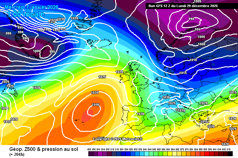
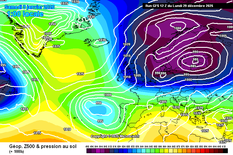
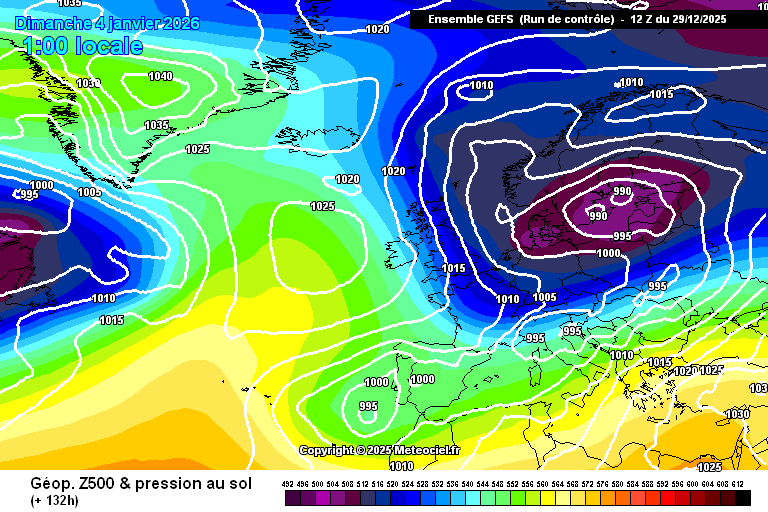
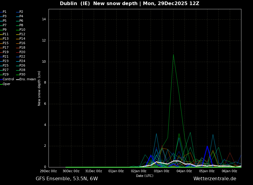
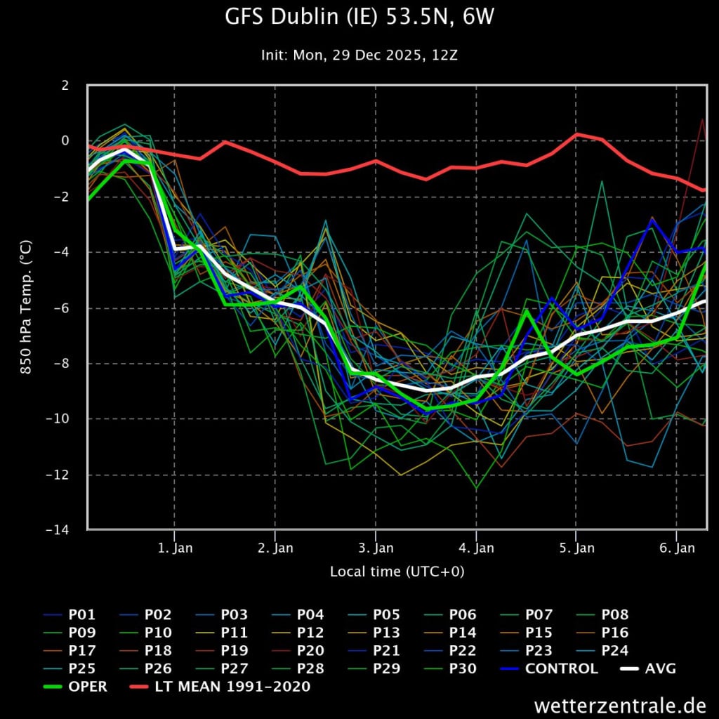
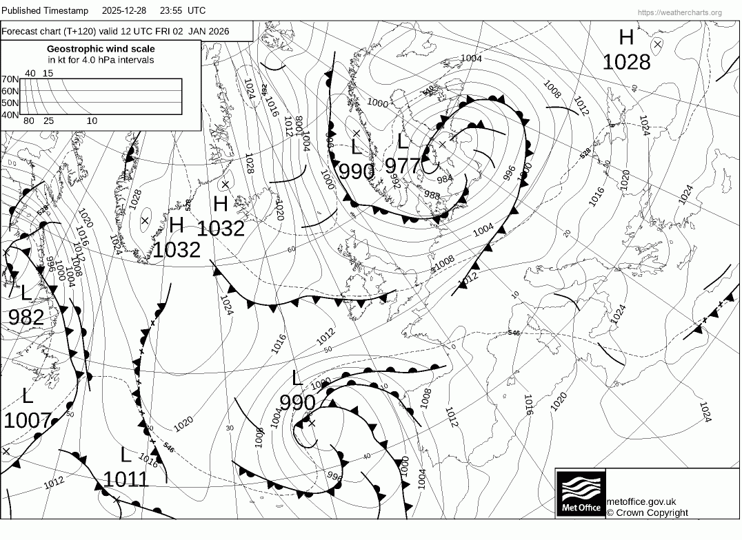
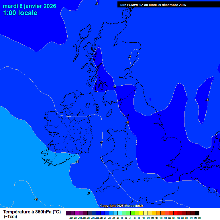
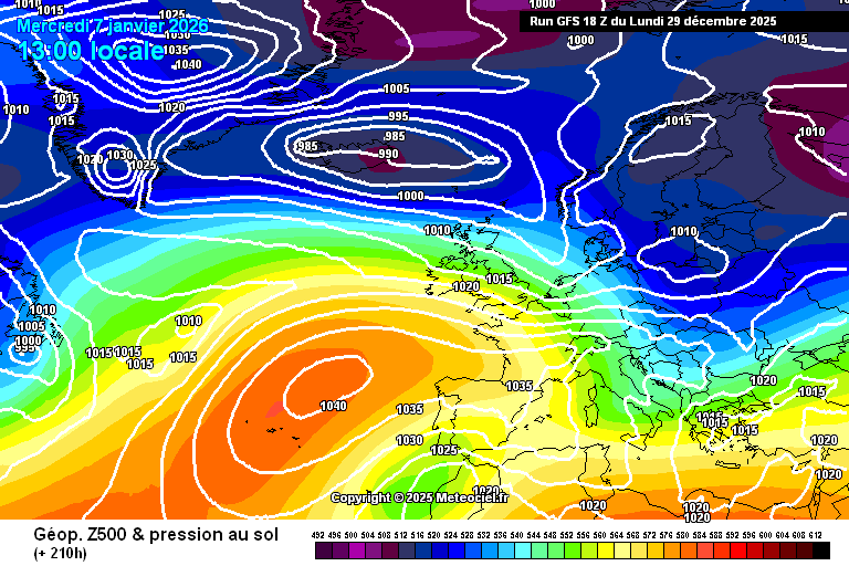
Friday Jan 2nd onward, very cold with snow potential: Event buildup/discussion

1246737

Comments

  • Registered Users, Registered Users 2 Posts: 3,823 ✭✭✭JanuarySnowstor


    Gfs follows morning run this evening. A bit more excitement in the UK, we are first to lose the cold flow

    copyImage.png


  • Moderators, Science, Health & Environment Moderators Posts: 1,916 Mod ✭✭✭✭WolfeEire
    Clare (430ft asl)


    If you are a fan of cold, wintry weather in Ireland, the key to model watching is "get the cold in first" and worry about where precipitation may fall and longevity after.

    Forecast models tend to have a built-in bias towards a return of Atlantic influence, and that signal is evident in this afternoon’s runs. However, both the UK Met Office and Met Éireann remain confident that colder conditions will persist well into next week. With access to a broader and higher-resolution dataset than the publicly available output, they are better placed to see beyond the short-term noise that often dominates the ensemble charts.

    Please keep discussion in this thread civil. General winter weather commentary should be posted in the Winter Thread so readers can more easily follow the contributions of our model watchers. Please do not be offended if your general winter commentary is moved to the aforementioned thread. Thank you.


  • Registered Users, Registered Users 2 Posts: 2,291 ✭✭✭John.Icy


    And much closer to the reliable…

    image.png

    I agree on one thing JS, unlike the UK, we quite simply can't afford corrections east. The high will collapse either way as I said earlier, as it was never going to just stay put for days on end. But if it collapses SE rather than S…then yes, we get kicked out of the unstable flow and lower thickness quicker. But we have time to play with still. Just days ago (25th) there was calamity and little hope. Now we have charts the forum dreamed of mere days away and your focus is solely on the breakdown!

    A nice ECM which avoids pulling the HP SE too close to us would be most welcome.


  • Registered Users, Registered Users 2 Posts: 6,533 ✭✭✭Elmer Blooker


    the Atlantic will encroach at some stage obviously but don’t forget even professional meteorologists cannot accurately predict nine days ahead.


  • Registered Users, Registered Users 2, Paid Member Posts: 424 ✭✭ascophyllum


    Both GFS and GEM show it as a Friday-Monday cold spell, Atlantic back by Tuesday morning.


  • Advertisement
  • Registered Users, Registered Users 2 Posts: 3,823 ✭✭✭JanuarySnowstor


    Control, very cold but high moving in by Saturday evening. No ppn with the high that close I'm afraid

    copyImage.png


  • Registered Users, Registered Users 2 Posts: 3,506 ✭✭✭Rebelbrowser


    And if any of us get snow in that three day cold spell it will be well worth it! Snow here is rare, enjoy the chase…


  • Registered Users, Registered Users 2 Posts: 419 ✭✭Condor24


    Disappointing latest GFS run to my eyes, shunts things a bit east. Still getting the -8 lines over us, so a very cold couple of days to come, perhaps three. After that it's the Atlantic show again...I'm keen to see how the ECM handles this tonight.


  • Moderators, Science, Health & Environment Moderators Posts: 1,916 Mod ✭✭✭✭WolfeEire
    Clare (430ft asl)


    Snow spikes appearing for Dublin on this afternoon's GFS. The white line represents the mean depth of all ensemble members. Looking bitterly cold, especially in a moderate northerly or north-easterly. The operational run is a little too eager to bring the Atlantic back in early next week.

    ens_image.png gfs-dublin-ie-535n-6w.jpeg


  • Registered Users, Registered Users 2 Posts: 364 ✭✭ClimateObserver


    image.png

    Nice fax chart for midday Friday. Cold front likely to bring some snow.


  • Advertisement
  • Registered Users, Registered Users 2 Posts: 3,821 ✭✭✭.Donegal.


    UK outlook but sounds decent

    Saturday 3 Jan - Monday 12 Jan

    Northerly winds will bring a spell of very cold, wintry conditions to much of if not all of the UK through at least the early part of this period. These will bring snow showers to areas that are exposed to onshore winds. Subtle day-to-day changes in wind direction will change the places most exposed to the showers, but where they occur some significant accumulations of snow are likely. There are likely to be some more coherent bands of sleet and snow working south, and these may bring a risk of more prolonged and widespread wintry precipitation affecting some inland areas. Things become less certain by the second week of January, however it's possible the cold conditions may persist with an ongoing risk of winter hazards across much of the UK.


  • Registered Users, Registered Users 2 Posts: 3,902 ✭✭✭pureza


    528 dam line is behind it so No except on or near hills maybe or in some of the usual inland spots

    Coastal areas .forget it


  • Moderators, Science, Health & Environment Moderators Posts: 1,916 Mod ✭✭✭✭WolfeEire
    Clare (430ft asl)


    ECM out to Tuesday morning

    ECU0-192.gif


  • Moderators, Science, Health & Environment Moderators Posts: 18,345 Mod ✭✭✭✭Gonzo


    my first time to talk on this thread since I've been away for quiet a while. I'm not excited for this yet, I want to see things shift west so there is more of a guarantee of precipitation around. It's too early to really talk about precipitation yet but I want to see upgrades in the unstable department before getting excited and perhaps uppers as well. Having gone so many years with cold spells that are cold enough for snow but no precipitation around and cold spells that have been too early or too late and cold rain over the years have left me very low key with this one.

    If it's an easterly and uppers are only -7 thats rain for most low lying locations in the east, it's the same deal in the west. If it's a north-westerly and uppers only -6 or -7 those populated areas in the west and north-west where most people live are going to see cold rain with bits of sleet mixed in. Different story if the rain/showers make their way well inland. I'm reserved for now until I wake up in the morning to see a solid suite of cross model upgrades in terms of upper air temperatures and more general unstable conditons.

    What I don't want is cold just for the sake of it with nothing to show, that's just a major increase in fuel bills without the actual payoff of seeing white gold fall from the sky. Tomorrow morning to the 12z last chance for upgrades.


  • Registered Users, Registered Users 2, Paid Member Posts: 424 ✭✭ascophyllum


    ECM brings back Atlantic air by Tuesday morning too now.


  • Registered Users, Registered Users 2 Posts: 419 ✭✭Condor24


    You know its over before it's even started when the tabloids are talking about possible school closures from the upcoming 'Arctic blast'....😏


  • Registered Users, Registered Users 2 Posts: 17,057 ✭✭✭✭Flinty997


    Never had a problem with Cross Climates. Had them on a number of cars.

    Love the snow speculation even if it doesn't happen.


  • Registered Users, Registered Users 2 Posts: 26,194 ✭✭✭✭Kermit.de.frog


    It's looking good for Friday to Monday/Tuesday however things will change again for next week so I wouldn't focus on that part too much for now, it's 7 days out.

    At this point most of the snow will be in the northwest and windward west coasts (still can't rule out the east coast coming in to play if we get a bit of luck with the wind direction) but there are opportunities other than that as well. Friday should bring some sleet and snow south although accumulations away from the north and high ground sparse at this point, still needs to be watched.

    Then with a very cold airmass in place frontal systems off the north Atlantic sliding up against it could bring snowfall next week but it's too early to talk specifics on that. Are we talking a big Atlantic push or a series of weaker cut off low pressures? Don't know yet. Some of the models already show some potential for that but we'll have a better clue later in the week.

    All in all not bad. I wouldn't get upset just because a series of runs one day nudges things west or east. It will be backward and forward, always is.

    Bank the weekend for now, next week will work itself out 🥶


  • Registered Users, Registered Users 2, Paid Member Posts: 7,925 ✭✭✭Calibos


    Planned to get my first set Autumn 2017. They didn't make 245/40 R18's at the time and I was getting conflicting info about being able to fit 245/45 R18's instead and then talked myself out of it and bought another set of Summer Pirellis because what where the odds we'd get more than a dusting and something decent like 2010 within the next 5 years anyway….Turns out about 4 months later in February 2018. Arrghh!!

    I do low mileage and so didn't need a Tyre replacement again till last year and this time Michelin were doing the Cross Climate 2's in 245/40 R18 so I ordered a set in January 2025. They arrived a week after the january 2025 Wicklow Mountain snow. My main reason to invest in a set was not because I need them for a commute or anything like that. I'm just sick of being deflated when no matter what the forecast, odds are Bray will miss out on snow….and yet the Wicklow mountains just up the road from me will get a few inches at some point most years. Literally right on my doorstep and I've never taken advantage of it. I want to replace that near guaranteed disappointment several times each Winter when Bray and Coastal Wicklow/Dublin is on the wrong side of the usually marginal setups, with a near guaranteed snow fix most years with a trip up to Ballinastoe Woods, or Roundwood or Glendalough with the Camera and the Dogs. Now I'm not talking about bypassing Garda road closures and driving up Sallygap to Lough Tay etc but it seems the council do a decent job of clearing the main road to Roundwood, Laragh, Glendalough etc. I'd be confident enough that the Cross Climates can deal with compacted stuff or a couple of inches that fall on the way there or back between ploughings and grittings etc. Based on some Wicklow mountains Snow video content online, most are going up on Summers and being perfectly fine on the well treated roads with the exception of the gobshites that take that right turn onto the R759 and drive around the barriers and drive up to Sally Gap in their FWD or RWD on Summer tyres. I have always been risk averse and wouldn't even risk the main road on Summers. LOL. Cross Climates are giving me that little bit of reassurance I needed.

    Sounds like barring a total lack of precipiation or wind direction not playing ball, I'm virtually guaranteed to get a snow fix next weekend, if not in Bray, then a few miles up the road in the Wicklow Mountains.


  • Registered Users, Registered Users 2 Posts: 630 ✭✭✭Ros4Sam24


    I think we’re in a bit of a waiting period now. Very cold conditions look locked in towards the weekend but we are left with 2 questions

    1. Will the pattern be sufficiently west and bring disturbances for more areas leading to more widespread snow.
    2. Will the block to our northwest be shunted quickly next week, or will reinforcements come in the sense of WAA in the Atlantic.


  • Advertisement
  • Registered Users, Registered Users 2 Posts: 7,444 ✭✭✭OldRio


    Tyre changes for this? Seriously?


  • Registered Users, Registered Users 2 Posts: 1,237 ✭✭✭compsys


    To be honest, at this stage I’d be happy with a cold, dry northerly for a few days as at least that means sun. It’s probably the one set-up that almost guarantees sunshine for Dublin. More so than any set-up in spring or summer.

    While it’s been very settled the past week, it’s been really grey and cloudy in Dublin most days. I find this type of weather really depressing. At least when it’s wet and windy there’s often plenty of sun in between the showers for Dublin at least.

    So bring on the sunshine!


  • Registered Users, Registered Users 2 Posts: 3,823 ✭✭✭JanuarySnowstor


    Just a few quick comments before the 18z Icon and Gfs roll. First of all thanks to Kermit for starting this thread, certainly justified no matter what lands!! I'm quietly confident that we might be at the back end now of negative adjustments and a few upgrades are overdue. Whatever about longevity the depth of cold has remained throughout and minus 8 uppers reaching the South Coast are not to be sneezed at! Also nearly every model shows kinks in the isobar which suggest some snow could well be around. An ice day on Sunday and Monday is very probable, again something that doesn't happen every year, indeed every 5.

    Apologies for being negative earlier guys, I've been up since 4am and it takes its toll when you get to my age 😆

    So buckle up the 18s are now rolling....


  • Registered Users, Registered Users 2 Posts: 2,364 ✭✭✭red_bairn


    So an ice rink on Monday morning? Gotcha! (Close the schools folks!) ;)


  • Registered Users, Registered Users 2, Paid Member Posts: 18,231 ✭✭✭✭Goldengirl


    Exactly.

    Good if it happens . And if not interesting to read all the interesting and informative weather posts , especially for those of us who haven't the foggiest 😁


  • Registered Users, Registered Users 2, Paid Member Posts: 7,925 ✭✭✭Calibos


    No. The potential for some snow no matter how slim simply put safety/traction measures on the mind of someone who moved to 220m ASL a few weeks ago and hadn't thought about it till reminded by this particular potential snow episode.


    I simply answered Chains (expensive and unlikely needed except in extreme Snow/Ice events), Snow Socks and if a tyre change is needed soon anyway, might as well buy some good latest gen All Seasons.


    No one is talking about tyre changes specifically for this spell but this potential spell especially for Snow bunnies that live close to mountains nevermind actual mountain dwellers is a reminder that new gen All Seasons are worth considering at their next tyre change. ie. I didn't change my tyres to Snow rated All Season Cross Climates last January for this specific spell but for any spell that happens during the lifetime of the tyres over the next few years cause I plan to drive up a bit into the Wicklow mountains for my snow fix from now on instead of moaning here that Bray hardly ever gets any (while the Wicklow mountains on my doorstep gets some snow for a few days most years.)


  • Registered Users, Registered Users 2 Posts: 4,346 ✭✭✭Dazler97


    just found this thread , buzzing for some proper winter weather


  • Registered Users, Registered Users 2 Posts: 388 ✭✭scooby77


    Just out of curiosity I asked Gemini and Chatgpt for a forecast (Location is a dropped pin within 2km of my location)...one to check back on after the event...

    https://gemini.google.com/share/25f4b12a9c5d

    https://chatgpt.com/s/t_695301cea6b08191be68ca67c0749e8e


  • Registered Users, Registered Users 2 Posts: 3,823 ✭✭✭JanuarySnowstor


    Sorry guys but this is dead in the water! It's one way traffic since this morning and not only is longevity at stake but the whole event is now under question!!!!

    17670475529705222196376368561856.png


  • Advertisement
  • Registered Users, Registered Users 2 Posts: 630 ✭✭✭Ros4Sam24


    Can you please stop thinking you have unveiled something new. Day 9 is FI and you know that, a number of options on the table. To say the whole event is under question is madness.


This discussion has been closed.
Advertisement
Advertisement