Advertisement
If you have a new account but are having problems posting or verifying your account, please email us on hello@boards.ie for help. Thanks :)
Hello all! Please ensure that you are posting a new thread or question in the appropriate forum. The Feedback forum is overwhelmed with questions that are having to be moved elsewhere. If you need help to verify your account contact hello@boards.ie
Help Keep Boards Alive. Support us by going ad free today. See here: https://subscriptions.boards.ie/.
If we do not hit our goal we will be forced to close the site.

Current status: https://keepboardsalive.com/

Annual subs are best for most impact. If you are still undecided on going Ad Free - you can also donate using the Paypal Donate option. All contribution helps. Thank you.
https://www.boards.ie/group/1878-subscribers-forum

Private Group for paid up members of Boards.ie. Join the club.

Interesting Maps

1356357358359361

Comments

  • Moderators, Social & Fun Moderators, Paid Member Posts: 13,870 Mod ✭✭✭✭JupiterKid


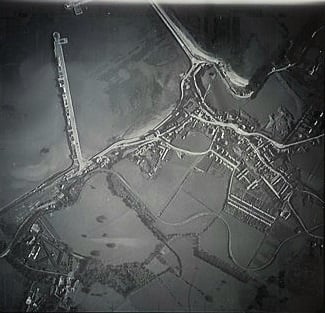
    1938 Air Corps aerial photo of Howth

    25988383567_5abfdfe6b2_w.jpg


  • Moderators, Social & Fun Moderators, Paid Member Posts: 13,870 Mod ✭✭✭✭JupiterKid


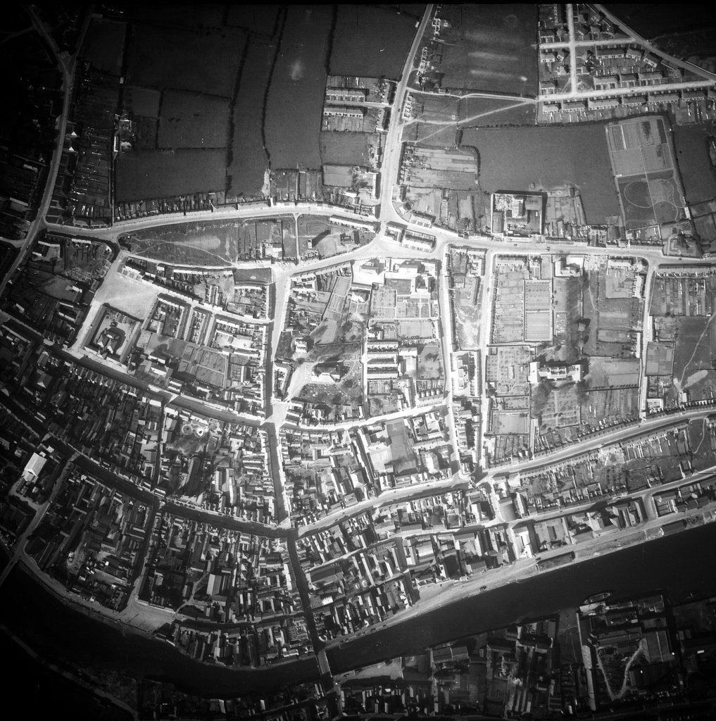
    1938 Air Corps aerial photo of Drogheda.

    40860292621_600851031c_k.jpg

    The River Boyne is in the lower part of the image.


  • Registered Users, Registered Users 2 Posts: 1,839 ✭✭✭rock22


  • Moderators, Sports Moderators Posts: 7,505 Mod ✭✭✭✭cdeb


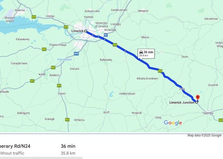
    But Limerick Junction is where you change trains to get the Limerick train. Not comparable to the Gakugei University example. The one place Limerick Junction can't be is in Limerick


  • Moderators, Category Moderators, Arts Moderators, Sports Moderators, Paid Member Posts: 53,864 CMod ✭✭✭✭magicbastarder


    Limerick junction is not 36km from Limerick, it's a couple of km from Limerick.


  • Advertisement
  • Registered Users, Registered Users 2 Posts: 7,074 ✭✭✭Badly Drunk Boy


    From Wikipedia:

    Gakugei-daigaku Station opened on 28 August 1927.
     It was named after the Tokyo Gakugei University, but the campus moved to Koganei in 1964. The Tokyo Gakugei University Senior High School opened in 1954 remains near this station.

    This explains the name, but not why they didn't rename the station to something more appropriate/helpful.


  • Moderators, Sports Moderators Posts: 7,505 Mod ✭✭✭✭cdeb


    No it's not?

    Limerick Junction is just outside Tipp Town. It's close to the border with Limerick County, but that's not why it's called Limerick Junction.


  • Moderators, Category Moderators, Arts Moderators, Sports Moderators, Paid Member Posts: 53,864 CMod ✭✭✭✭magicbastarder


    yes, it's close to the border with the county, which was my point. limerick is not just a city, it's a county.

    the poster i was responding to seemed to be suggesting that the junction should be beside limerick city to warrant being called limerick junction.


  • Moderators, Sports Moderators Posts: 7,505 Mod ✭✭✭✭cdeb


    Well the point of it is it's where you change for the train to Limerick City (which is the next stop on the line), so it does take its name from the city, not the county.


  • Registered Users, Registered Users 2 Posts: 780 ✭✭✭minggatu


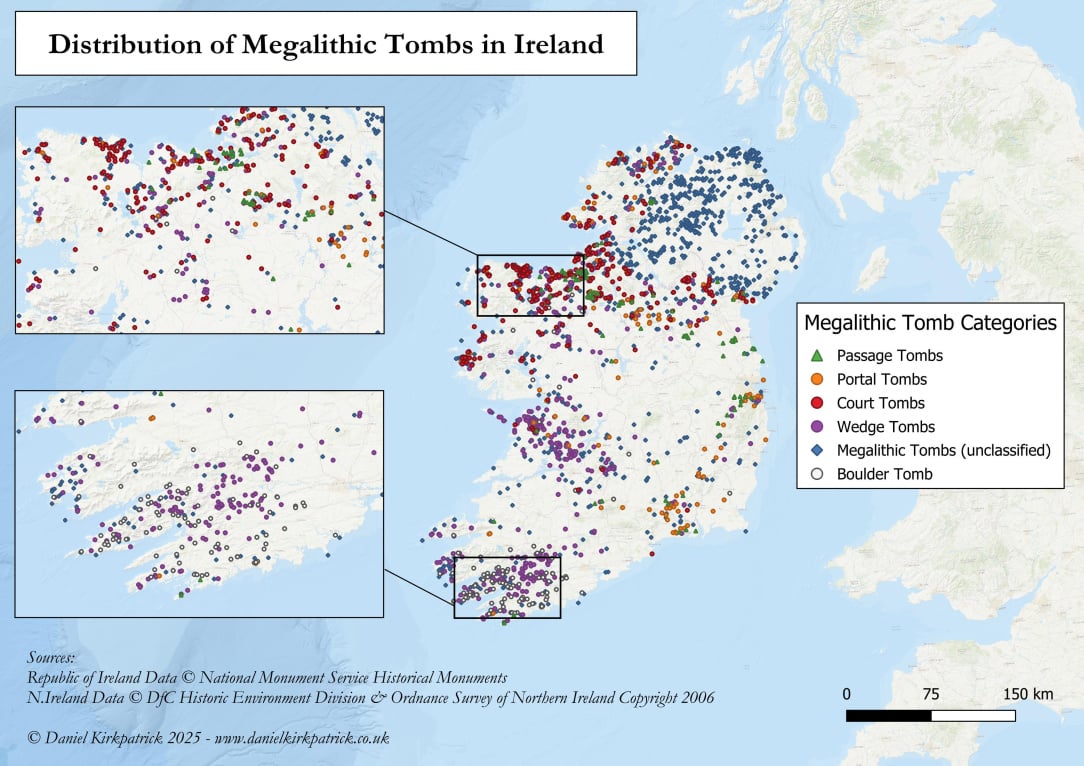
    Distribution of Megalithic Tombs in Ireland n7q2keaujxjf1.jpeg

    https://www.reddit.com/r/MapPorn/comments/1mubwd7/distribution_of_megalithic_tombs_in_ireland/


  • Advertisement
  • Registered Users, Registered Users 2 Posts: 4,214 ✭✭✭Brief_Lives


    fairly generalised classification for northern ireland.


  • Registered Users, Registered Users 2 Posts: 6,861 ✭✭✭Evade


    A bit of a trek for students enrolled at the time


  • Moderators, Category Moderators, Arts Moderators, Sports Moderators, Paid Member Posts: 53,864 CMod ✭✭✭✭magicbastarder


  • Registered Users, Registered Users 2 Posts: 8,025 ✭✭✭GerardKeating


    It was not always the next stop on the line, there used to be a few stops in between

    image.png


  • Registered Users, Registered Users 2 Posts: 73,836 ✭✭✭✭L1011


    One of which randomly got new station signage installed in the 80s despite being closed for years at the time:

    Dromkeen


  • Registered Users, Registered Users 2 Posts: 5,924 ✭✭✭silliussoddius


  • Moderators, Social & Fun Moderators, Paid Member Posts: 13,870 Mod ✭✭✭✭JupiterKid


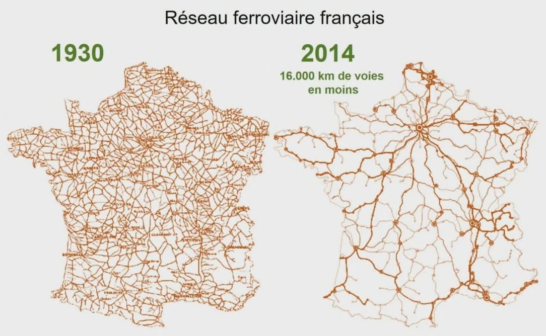
    Rail network in France, 1930 and 2014

    FB_IMG_1755668591624.jpg


  • Registered Users, Registered Users 2 Posts: 15,200 ✭✭✭✭M.T. Cranium


    You don't want to use GPS if you travel in back country areas of western North America, you are likely to get routed on forest service roads or worse that do travel in shortest distance from point A to B, but become undrivable for average cars at some point. I know of at least ten cases where people got stranded and in some cases perished because they believed GPS navigation. One recurrent problem is that some of the roads lead up into higher terrain that becomes snow covered and impassible. If a snowstorm hits just as the person realizes they are in that sort of area, they may not be able to get back out. This happened to a couple from Kelowna, BC travelling to Las Vegas by road in March of some recent year (about ten years ago) … they were routed through a mountain range on a dirt road, became stuck, and couldn''t reverse the vehicle. For some unknown reason, the man decided to try to hike the entire 35 miles they had intended to drive, and died of exposure about five miles further into the wilderness (a better idea would have been to hike back to lower elevations and nearby ranches). The woman stayed put, survived for six weeks into early May on snack food they had with them, until discovered by teenagers on all-terrain vehicles making a spring-time run up the road. She survived the experience. In another similar case, a couple froze to death after their car ran out of gas on a high altitude road between Palm Springs and coastal California in mid-winter conditions. It snows fairly heavily at altitudes above 7,000 feet in southern California when it's raining on the coast.

    And I recall several other better outcomes, but by definition an isolated back road is not a place where you're likely to be found by random travelers. One couple were very lucky in southern Utah to be discovered after two days (their car broke down after 35 miles of backroad shaking) by a rancher who just happened along to check on a herd that had been left to roam the wilderness for the season. Another guy was pulled out by helicopter after managing to connect on his cell phone and report an approximate position in snow-covered back country near Death Valley National Park (the north end of which is a lot higher than sea level). If he hadn't connected by phone, nobody would have had any clue he had taken the snowed-in back road.

    Sort of map related anyway. I have on occasion taken back roads myself but my rule is, never go to a point where a fit old man cannot walk out. Whether I am a fit old man or not has never been fully tested out.


  • Moderators, Recreation & Hobbies Moderators, Science, Health & Environment Moderators, Technology & Internet Moderators Posts: 95,805 Mod ✭✭✭✭Capt'n Midnight


    The main uses for google maps are traffic updates while driving , and to suggest alternative routes when planning.

    On a computer it's much easier to drag the start point around to see what options it gives. You have to watch like a hawk in mountainous areas as there may be another route using good roads that might take a minute longer. The last time I got sent on a gravel track to save 1 minute was today.

    Abroad incorrect entrances and marking farm paths as public roads is so common that you must use street view or satellite view to see if there's any clues.


  • Registered Users, Registered Users 2, Paid Member Posts: 2,898 ✭✭✭Hoop66


    First time I ever used sat nav, about 20 years ago in France, I put in the co-ordinates of the campsite but we were taken to an entrance to a forest track about 30 km away from the actual entrance to the camp.


  • Advertisement
  • Registered Users, Registered Users 2 Posts: 1,839 ✭✭✭rock22


    Many railway stations with junctions in their name refer to the location of the station, eg. Clapham junction, ( but many old stations in Ireland too, ) and not to one of the destinations which can be reached from that junction.

    So yes, it can be confusing because as travelers expect to find Beckenham junction in Beckanham, or Clapham junction in Clapham they might also expect to find Limerick junction in Limerick.

    Obviously, if you know this is where you get the train to limerick, then you aren't confused.


  • Moderators, Sports Moderators Posts: 7,505 Mod ✭✭✭✭cdeb


    Oh, that's interesting.

    The only other one I could think of here is Howth Junction, which isn't in Howth - it's where the line branches off for Howth.

    That said, wiki says of Clapham Junction "Despite its name, Clapham Junction is not in Clapham, a district 1 mile (1.6 km) to the south-east."


  • Registered Users, Registered Users 2 Posts: 73,836 ✭✭✭✭L1011


    Bundoran Junction station was in Irvinestown, Tyrone.


  • Registered Users, Registered Users 2 Posts: 780 ✭✭✭minggatu


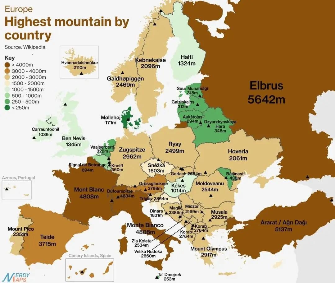
    Highest mountain by country

    699wn5liibkf1.jpeg

    https://www.reddit.com/r/MapPorn/comments/1mw3gmg/from_rportugalcykablyat/


  • Registered Users, Registered Users 2, Paid Member Posts: 36 DrivingSouth


    Manulla Junction is named after where it is and not called Ballina Junction. You could argue it depended on whether the location was a destination in itself that people would know ie Clapham. Whereas there was little in the location of howth junction or limerick junction at the time so using a townland name might not be that helpful. But Manulla doesn't fit that definition.


  • Registered Users, Registered Users 2 Posts: 537 ✭✭✭dublincc2


    Aerial photo of Kilbarrack in 1971

    IMG_3434.jpeg


  • Registered Users, Registered Users 2 Posts: 2,748 ✭✭✭Thud


    We drove from Kelowna to Whistler a few years ago, large sections of that (main) route through the mountains were rough gravel and it wasn't flagged on Google maps (possibly was damage from snow or snow melt flooding), not something you'd want to risk in any other seasonal bar summer, you'd think a fella from Kelowna should probably have expected something like that.


  • Moderators, Science, Health & Environment Moderators Posts: 5,467 Mod ✭✭✭✭spacetweek


    Everyone thinks of the Netherlands as the flattest country in Europe but I’m surprised to see that Estonia, Latvia, Malta and especially Denmark have even lower mountains.


  • Registered Users, Registered Users 2 Posts: 31,771 ✭✭✭✭zell12


    Do they feature the WWII-era Torpedo on Tory? 😝


  • Advertisement
  • Registered Users, Registered Users 2 Posts: 41,041 ✭✭✭✭ohnonotgmail


    I can't place that at all. Are there any current landmarks that i could use to anchor it? For instance where is the spot the train station is now


Advertisement