Advertisement
If you have a new account but are having problems posting or verifying your account, please email us on hello@boards.ie for help. Thanks :)
Hello all! Please ensure that you are posting a new thread or question in the appropriate forum. The Feedback forum is overwhelmed with questions that are having to be moved elsewhere. If you need help to verify your account contact hello@boards.ie
Help Keep Boards Alive. Support us by going ad free today. See here: https://subscriptions.boards.ie/.
If we do not hit our goal we will be forced to close the site.

Current status: https://keepboardsalive.com/

Annual subs are best for most impact. If you are still undecided on going Ad Free - you can also donate using the Paypal Donate option. All contribution helps. Thank you.

Interesting Maps

1356357358360362

Comments

  • Registered Users, Registered Users 2 Posts: 772 ✭✭✭minggatu


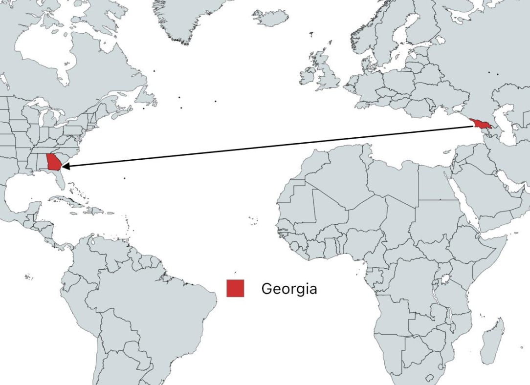
    You can sail in a straight line from Georgia to Georgia

    GyLEVsZXYAAWZ-W.jpg

    https://x.com/TerribleMaps/status/1955341067781382301/photo/1


  • Registered Users, Registered Users 2 Posts: 3,190 ✭✭✭Bogwoppit


    I should have read the website address before I got angry.


  • Registered Users, Registered Users 2 Posts: 31,719 ✭✭✭✭zell12


    Anyone want to put up a map of Boundary Road WA & 0 Avenue BC, and why the parallel roads exist..


  • Registered Users, Registered Users 2, Paid Member Posts: 23,392 ✭✭✭✭dxhound2005


    List of world map projections. The African Union has joined calls for Mercator to be abandoned in favour of something which shows Africa on a more correct scale.

    https://en.wikipedia.org/wiki/List_of_map_projections

    https://www.ecofinagency.com/news/1508-48067-africa-s-true-size-the-african-union-pushes-to-redraw-the-world-map


  • Registered Users, Registered Users 2 Posts: 772 ✭✭✭minggatu


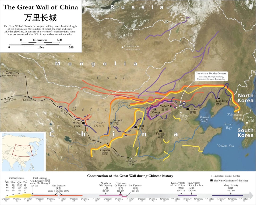
    Map of The Great Wall Of China Map_of_the_Great_Wall_of_China-2048x1647(1).jpg

    "

    The map above shows the location of the Great Wall of China. However, unlike popular imagination, the Wall is actually more complex than on simple unbroken straight stone structure."

    Here’s more about it:

    https://brilliantmaps.com/map-of-the-great-wall-of-china/


  • Advertisement
  • Registered Users, Registered Users 2 Posts: 14,243 ✭✭✭✭The Nal


    You can see the moon from the Great Wall of China


  • Moderators, Arts Moderators, Recreation & Hobbies Moderators, Social & Fun Moderators Posts: 79,081 Mod ✭✭✭✭New Home


    Post of the week! 😁😁😁

    I bet you can even tell us which month has 28 days. 😄


  • Registered Users, Registered Users 2 Posts: 6,855 ✭✭✭Evade


    Seems like a non starter if the AU's members haven't adopted an alternative yet


  • Registered Users, Registered Users 2 Posts: 772 ✭✭✭minggatu


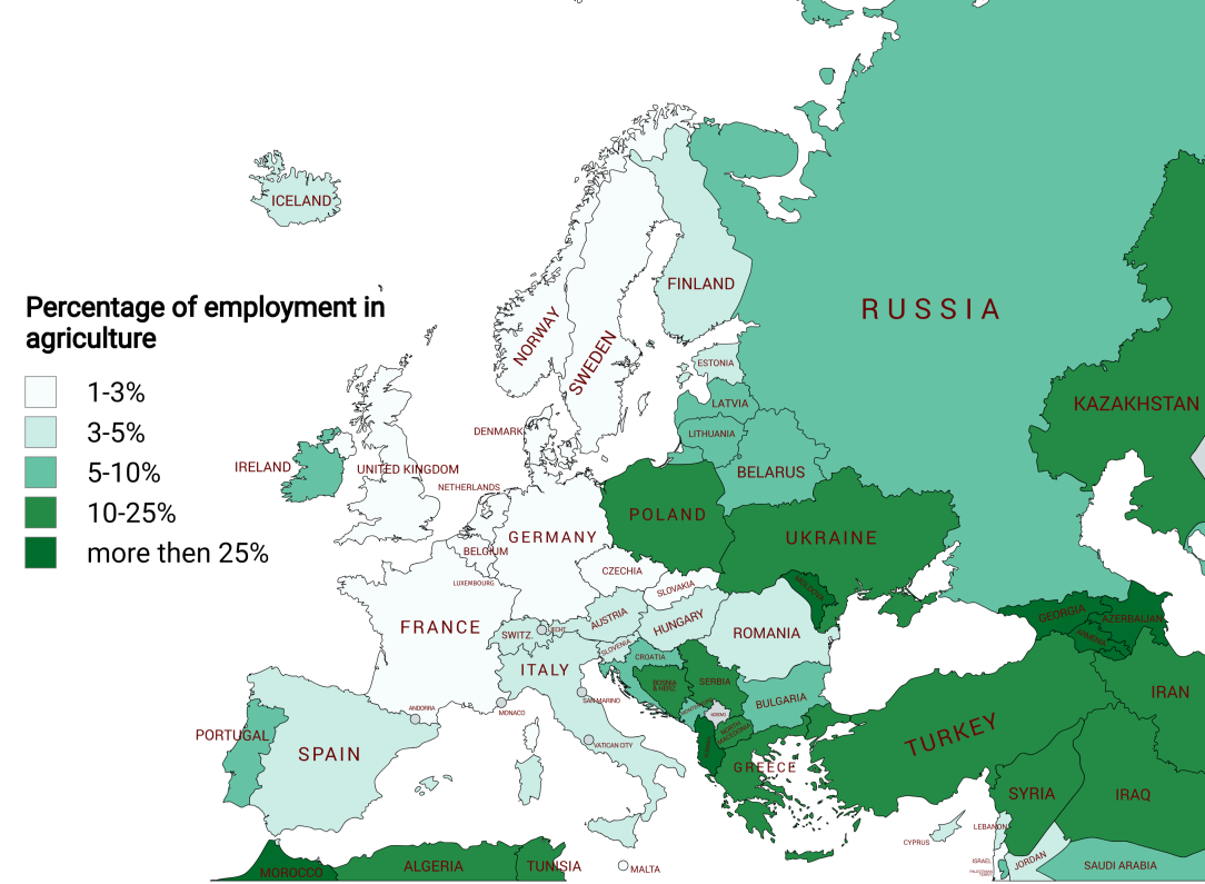
    Employment in agriculture across europe bguscnf8fdjf1.png

    https://www.reddit.com/r/MapPorn/comments/1mrt5xx/employment_in_agriculture_across_europe/


  • Registered Users, Registered Users 2 Posts: 772 ✭✭✭minggatu


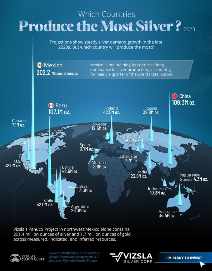
    Which countries produce the most silver? 2023 gicumgbylkjf1.jpeg


  • Advertisement
  • Moderators, Science, Health & Environment Moderators Posts: 5,461 Mod ✭✭✭✭spacetweek


    Explanation : 1 million (Troy) ounces = 31 tonnes.

    Mexico’s 202.3 M oz = 6,268 t.


  • Registered Users, Registered Users 2 Posts: 9,543 ✭✭✭Shedite27


    Sounds like they're pushing for the Equal Earth projection to be the standard

    Equal_Earth_projection_SW[1].jpg


  • Registered Users, Registered Users 2 Posts: 27 SaxySaxSolo


  • Registered Users, Registered Users 2 Posts: 6,855 ✭✭✭Evade


    Then they should probably adopt it across AU member states before trying to get the rest of thevworld to change


  • Registered Users, Registered Users 2 Posts: 772 ✭✭✭minggatu


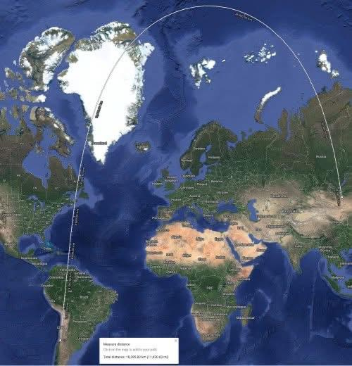
    The shortest route from Santiago, Chile to Ulaanbaatar, Mongolia x5pfg8jccsjf1.jpeg

    https://www.reddit.com/r/MapPorn/comments/1mtn2l8/the_shortest_route_from_santiago_chile_to/


  • Registered Users, Registered Users 2 Posts: 15,193 ✭✭✭✭M.T. Cranium


    Boundary Road WA and zero (0) Avenue BC exist on either side of a ditch which is the 49th parallel border between Canada and the U.S. … as there is no border crossing facility between 176 Street near White Rock BC and Aldergrove BC about 30 km east, there is no legal place to cross the international border, but both these streets run most of the way from one border crossing to the next, with houses on the far side of each street (not along the ditch).

    Zero Avenue ends a bit short of the Aldergrove crossing by making a jog north, crossing that approach road (BC Highway 13 or 264 Street) and resuming operation as Zero Avenue most of the way to the next border crossing which is Highway 11 south of Abbotsford BC (known as the Sumas crossing, Sumas WA is on the American side).

    People have occasionally tried to cross the ditch from one side to the other, but there is extensive electronic and video surveillance, and law enforcement would normally report within a few minutes from a fleet always mobile near the stretch of border. Of course, I have no data about successful evasions of this surveillance, there may be some or there may not be. But people have been apprehended and arrested. One high speed ditch-jumping exercise ended with fatalities in the vehicle involved.

    I cannot supply a map, you could consult google earth, but the schematic is as follows:

    176 … _________ ..192 St ………………………….. 264 St …………. x …

    St … Surrey BC … x…… Langley BC ……………… 264 St …………… x … Abbotsford BC

    _____________________________________ 0 Ave _____

    ============================== Ditch and electronic surveillance corridor

    ______________________________ Boundary Rd (WA state USA)

    note: 192 Street is the border between Surrey BC and Langley BC. Almost all streets in various cities around greater Vancouver are on a numerical grid system. Streets run north-south and avenues run east-west. The avenues start from the border (0 or zero Avenue) and the street system starts from around 40 Street in Delta BC and keeps going through Abbotsford where it reboots after 306 Street to a system of named streets in Abbotsford, but addresses conform to the system even beyond where the street numbers end.

    In the city of Vancouver an entirely different and unconnected system of numbered avenues exists, with the highest numbers in south Vancouver. Streets in Vancouver are not numbered but are instead named. In nearby Burnaby BC there are almost no numbered streets or avenues except for a few extensions of Vancouver main avenues here and there. As a courier I learned that addresses in Vancouver added 16 to avenue numbers, for example, 3200 Cambie Street would be found at 16 Ave. This is because the system ends before the grid ends and numbers along the north-south streets do not reverse. As to street numbers east-west, these reverse at Ontario Street which is just a few blocks east of Cambie Street, a main north-south route from downtown Vancouver towards the south end of the city. So an address of 3690 E 49 Ave would be at the Burnaby border and around the corner from 6500 Boundary Road (the name of the street on the Vancouver-Burnaby border).


  • Registered Users, Registered Users 2 Posts: 15,193 ✭✭✭✭M.T. Cranium


    Could add to the above, most western U.S. and Canadian towns and cities have a numerical grid of streets and avenues. It's a common practice (not observed in the Vancouver area systems) to name the avenues and the streets with two zeroes added, as in 100 Avenue, 200 Avenue etc, and to start from a central point and work in sets of north and south avenues, west and east streets. None of that applies to Vancouver area grids. But it is the setup for Edmonton and a number of other large cities. So the avenue and street numbers are equal to addresses, a location of 7500 12000 St SE would be located where 75 Ave south crosses 120 St E, so it would be 75 avenues and 120 streets southeast of the central point downtown. Additional minor streets and avenues can be named A and B, for example, if there were a 7500A and 7500B Avenue in an industrial park, these would be two small streets between 7500 and 7600 Avenues. Streets that are not as straight as the grid, or run diagonally, would have names and often the designator Way (as in Canada Way, Burnaby, which runs diagonally across the Burnaby grid), or Highway or Drive.

    Some western towns have no numbered streets at all. It's fairly common in numbered-street grids for 100 Ave or 100 Street to be renamed Main Street, and sometimes one or two others lose their numbers to a name. In Vancouver, 9th Avenue is called Broadway. There is no zero avenue at the north end of the Vancouver grid, it starts with 1st Avenue (but there are sixteen blocks further north so the numbers on north-south streets have already reached 1600 crossing First Avenue). In fact, zero avenues are quite rare, the one near the U.S.-Canada border is one of very few examples.

    A lot of smaller places have a few numbered streets or avenues and lots of named streets and avenues. Where I live there are First to Fourth Avenues, no numbered streets, and the address system bears no relation to the four numbered avenues, the main street here is an avenue corresponding to zero avenue but not called that, and numbers along the streets running through the grid of four avenues move up from 2000 to 2400 (all the streets in this town have extensions in a south end of town that is across a gulch so none of the streets are continuous). The numbering system acts as if they were continuous. So the lowest house numbers on streets in town are at the south end of town. It is quirky and no other place has a similar grid as far as I've observed. The avenue addresses seem to start around 1600 in the west end and run up to 3000 at the east end, possibly a decision based on anticipated but never realized urban expansion further west. Another thing about this town that is almost unique in North America is the existence of maintained city streets with no names at all, but the numbering system is attached to the streets nearby. I would imagine couriers having problems finding some of these addresses.

    The numbered street system is also used in downtown Manhattan and a few other eastern cities, but is fairly rare east of the Mississippi. It is reversed in New York City, the avenues run north-south and the streets run east-west. Fifth Avenue for example runs north-south (NNE-SSW to be more precise).


  • Registered Users, Registered Users 2 Posts: 15,193 ✭✭✭✭M.T. Cranium


    In Toronto, there are no numbered streets or avenues except in a few places that used to be smaller towns and were absorbed into greater Toronto, so there would be a few neighbourhoods with numbered streets. Unlike western Canada, in Toronto streets do not all run north-south and avenues do not all run east-west. They are scattered around at random. It seems that further north, an effort was made to name east-west roads Avenues, all of the prominent routes are avenues north of Bloor Street in midtown Toronto. But in downtown Toronto, streets cross streets, there are few avenues and those run north-south. One prominent north-south street is Avenue Road just to confuse matters. A grid system in older North American towns often breaks down into a more random European style grid, and the streets in those areas are often named Crescent or Drive or Way, indicating the numbering system will not conform to the larger regional grid.

    I am not very familiar with Washington DC but I think the grid there is NW-SE and NE-SW oriented, and there is a system of avenues named after states running NW-SE (the White House is at 1600 Pennsylvania Avenue), and streets with letter names (A Street, B Street etc) run NE-SW.

    Vancouver has groups of street names with themes. To the east of Cambie Street are streets named after Canadian provinces, then rivers and other geographical features in BC. To the west are about twenty streets named after tree species followed by a few named after historical figures of the colonial era. Without looking at a map you can tell what part of Vancouver a street address is going to be.


  • Moderators, Science, Health & Environment Moderators Posts: 5,461 Mod ✭✭✭✭spacetweek


    Meh, I prefer our system:

    Each segment of road has a different name

    Always names never numbers*

    Passing through an intersection, sometimes the name changes, sometimes not

    Building Numbering is based on buildings not distance

    If a section of street never had buildings ( e.g. it was always a park) numbers skip that section. But if there used to be separate buildings there and now there is only 1 building, or they added a park later, those numbers are skipped.

    Lol!


    *A very rare exception is Cookstown Industrial Estate in Tallaght, which has First Avenue, Second Avenue etc.


  • Registered Users, Registered Users 2 Posts: 73,772 ✭✭✭✭L1011


    There's also a First to Fourth Avenue setup off Seville Place in Dublin.


  • Advertisement
  • Registered Users, Registered Users 2 Posts: 6,855 ✭✭✭Evade


    If you want to see a bonkers address system, try Japan. It starts off normal enough, although backwards compared to here, with country (usually omitted), then prefecture, city, and ward (district). All fine so far but then comes neighbourhood which is a weird irregular shape and finally building number which is usually, but not always, in order they were built. So the lowest number should be the oldest building. I'm not sure how anyone finds anything here without Google maps.

    And then there are other oddities like Gakugei University and Gakugei University station being 24km apart, ask me how I found that out.


  • Registered Users, Registered Users 2 Posts: 772 ✭✭✭minggatu


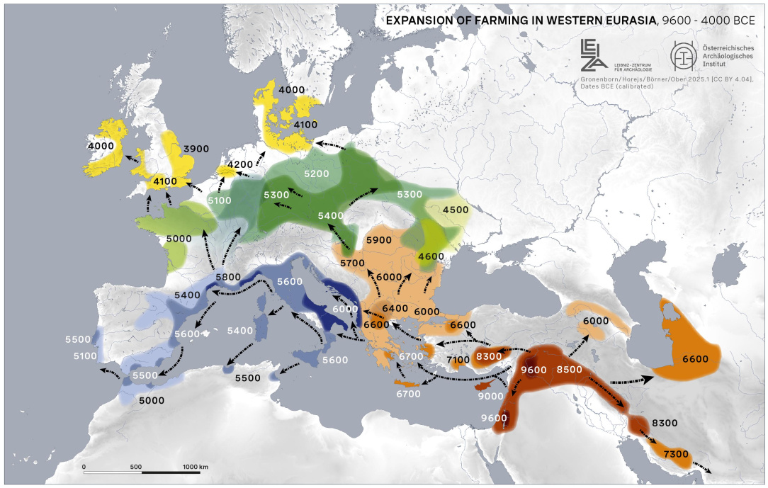
    Expansion of Farming in Western Eurasia, 9600-4000 BCE sx92rbsrfyjf1.jpeg

    https://www.reddit.com/r/MapPorn/comments/1muesic/expansion_of_farming_in_western_eurasia_96004000/


  • Registered Users, Registered Users 2, Paid Member Posts: 14,761 ✭✭✭✭josip


    Map of how to get from Gakugei Train Station to Gakugei University on foot 🙂

    image.png

    While engaged in this pedantic and somewhat pointless exercise, Google did throw some light on the situation however, by highlighting a "Gakugei University Senior High School" adjacent to the train station. Perhaps this is where it got its name from?


  • Registered Users, Registered Users 2 Posts: 228 ✭✭Irish History


    It's interesting to me that you should mention the correct scale of maps. I was once told that years ago, maps hanging on school walls left over from British rule in the south had the size of Britain upscaled to make Britain look bigger than say France or Spain on the European Continent. Does anyone know if there is any truth to this?


  • Registered Users, Registered Users 2, Paid Member Posts: 14,761 ✭✭✭✭josip


    Sounds like teachers of the day being aware of the effects of Mercator without having a proper understanding of it. Easier at the time to blame the British for it. But the British weren't the first to do this :)

    image.png


  • Moderators, Social & Fun Moderators, Paid Member Posts: 13,854 Mod ✭✭✭✭JupiterKid


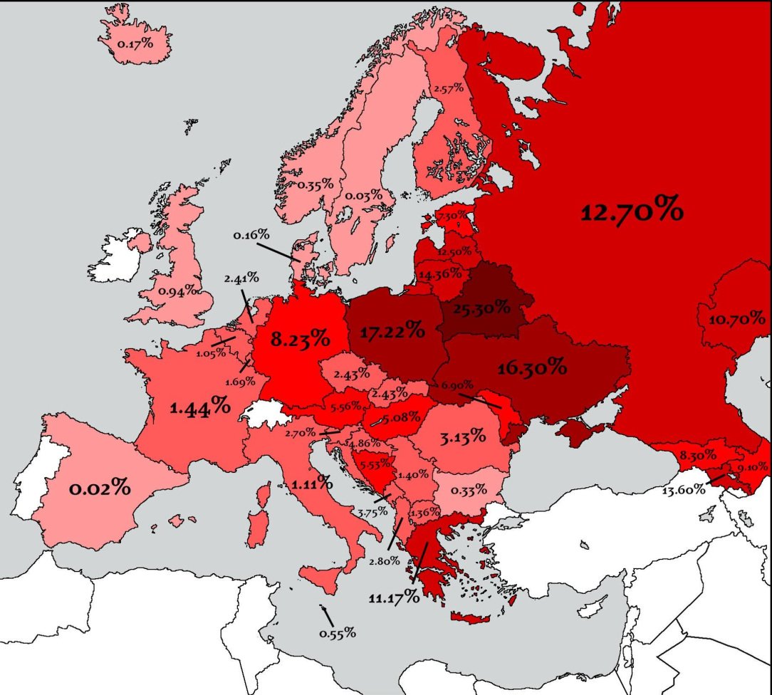
    Estimated percentage of each European country's population killed in World War 2

    Eastern European countries and Russia took very heavy losses in their populations compared to countries in the west.

    FB_IMG_1755624089663.jpg


  • Moderators, Social & Fun Moderators, Paid Member Posts: 13,854 Mod ✭✭✭✭JupiterKid


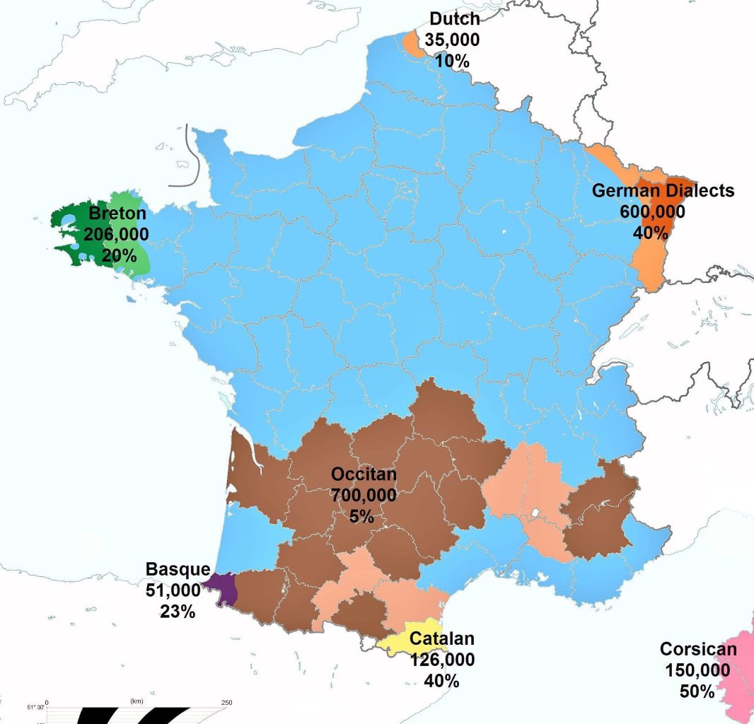
    Minority languages spoken in France by percentage in each department, 2022

    The French government does not officially recognise any of these languages/dialects apart from standard French.

    FB_IMG_1755558406283.jpg


  • Registered Users, Registered Users 2 Posts: 27 SaxySaxSolo


  • Registered Users, Registered Users 2 Posts: 6,855 ✭✭✭Evade


    They were both named after the same person so not quite the same.


  • Advertisement
  • Moderators, Social & Fun Moderators, Paid Member Posts: 13,854 Mod ✭✭✭✭JupiterKid


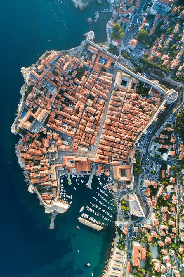
    High resolution satellite image of Dubrovnik old town, Croatia

    6shutterstock-335796056_main_1465464087492.jpeg


Advertisement