Advertisement
If you have a new account but are having problems posting or verifying your account, please email us on hello@boards.ie for help. Thanks :)
Hello all! Please ensure that you are posting a new thread or question in the appropriate forum. The Feedback forum is overwhelmed with questions that are having to be moved elsewhere. If you need help to verify your account contact hello@boards.ie

Interesting Maps

14647495152335

Comments

  • Moderators, Politics Moderators Posts: 42,866 Mod ✭✭✭✭Seth Brundle


    52e24ad76bb3f7fa7f0fd548?width=1200


  • Moderators, Politics Moderators Posts: 42,866 Mod ✭✭✭✭Seth Brundle


    zRDq4.png


  • Moderators, Politics Moderators Posts: 42,866 Mod ✭✭✭✭Seth Brundle


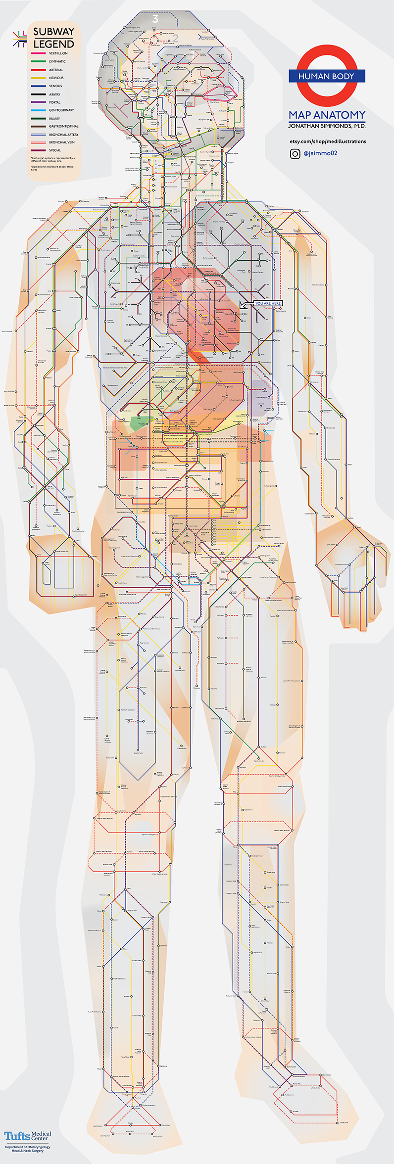
    An Illustrated Subway Map of Human Anatomy (source) - click on image for higher resolution version)

    human-anatomy-subway-map-sm.png


  • Banned (with Prison Access) Posts: 9,078 ✭✭✭IAMAMORON


    Could you post a link?

    Or repost in better definition? Apols for being needy, but I would like to have a good look.


  • Moderators, Sports Moderators Posts: 7,415 Mod ✭✭✭✭cdeb


    Double click on it for full res


  • Advertisement
  • Registered Users, Registered Users 2 Posts: 9,614 ✭✭✭Quantum Erasure


    So, around the Mediterranean, the Scandinavian peninsula, places where Europeans colonised... and Hokkaido island in Japan


  • Registered Users, Registered Users 2 Posts: 4,572 ✭✭✭KevRossi


    josip wrote: »
    Is this formulaic and consistent for every country or have countries negotiated better ratios?

    The EU uses degressive proportionality, there is a certain amount of horse trading every few years when it comes up to reallocate seats. There are currently 705 MEP's, there can be a max of 751. They could leave it at 705 and wait for the rest to be filled by future expansion, or increase the amount of seats per state.

    There's a lot more on it here, but it generally involves much negotiation/dealing/backstabbing at every expansion (or reduction thanks to Brexit).
    Representation is currently limited to a maximum of 96 seats and a minimum of 6 seats per state and the seats are distributed according to "degressive proportionality", i.e., the larger the state, the more citizens are represented per MEP. As a result, Maltese and Luxembourgish voters have roughly 10x more influence per voter than citizens of the six large countries.

    As of 2014, Germany (80.9 million inhabitants) has 96 seats (previously 99 seats), i.e. one seat for 843,000 inhabitants. Malta (0.4 million inhabitants) has 6 seats, i.e. one seat for 70,000 inhabitants.


  • Moderators, Politics Moderators Posts: 42,866 Mod ✭✭✭✭Seth Brundle


    Ryanair using maps to troll Aer Lingus...

    https://twitter.com/Ryanair/status/1310974827696713728


  • Banned (with Prison Access) Posts: 9,078 ✭✭✭IAMAMORON


    aerial-map-of-the-wicklow-mountains-foothills-flat-6048-1-p.jpg


  • Moderators, Social & Fun Moderators Posts: 13,547 Mod ✭✭✭✭JupiterKid


    My second post on this thread I originally created was a fantastic map of the river catchments of Ireland...

    ...now here is one of both Ireland and the UK. Enjoy! :cool:


    11417_ee0yfihk1boy2vlu.png


  • Advertisement
  • Registered Users, Registered Users 2 Posts: 5,057 ✭✭✭ablelocks


    Ryanair using maps to troll Aer Lingus...

    https://twitter.com/Ryanair/status/1310974827696713728

    ryanair customers use tweet to troll Ryanair into giving them updates on their refunds


  • Registered Users, Registered Users 2 Posts: 4,572 ✭✭✭KevRossi


    EjMtA81XYAIQ0uf?format=jpg&name=large


  • Registered Users, Registered Users 2 Posts: 9,140 ✭✭✭Gregor Samsa


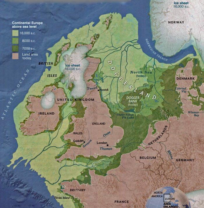
    Northwest Europe 18,000 years ago, when Ireland and Britain weren't islands, the North Sea was dry land, the River Barrow flowed into the Severn, and the Thames was a tributary of the Rhine.

    doggerland2sml-1-700x715.jpg


  • Registered Users, Registered Users 2 Posts: 5,609 ✭✭✭Padre_Pio


    I need to start printing some of these maps

    Countries that Britain has not invaded:
    the-only-countries-britain-has-not-invaded.jpg


  • Registered Users, Registered Users 2 Posts: 3,434 ✭✭✭chewed


    Padre_Pio wrote: »
    I need to start printing some of these maps

    Countries that Britain has not invaded:
    the-only-countries-britain-has-not-invaded.jpg

    So they invaded Iceland and Greece?


  • Registered Users, Registered Users 2 Posts: 3,971 ✭✭✭thomil


    chewed wrote: »
    So they invaded Iceland and Greece?

    They did indeed. Iceland was invaded during Operation Fork in 1940, to prevent its use as an air and submarine base by Nazi Germany. Officially, they went there to "protect" Ireland, but it was definitely an invasion.

    As for Greece, the british intervention in WW2 was on invitation of the Greek government, so that part is okay. However, during World War 1, the Entente powers, spearheaded by Britain, occupied Salonica, or Thessaloniki in order to pressurise the Central Powers in the Balkans. Greek Neutrality during that conflict was effectively ignored, and the intervention nearly pushed Greece into civil war.

    Good luck trying to figure me out. I haven't managed that myself yet!


  • Registered Users, Registered Users 2 Posts: 40,922 ✭✭✭✭ohnonotgmail


    chewed wrote: »
    So they invaded Iceland and Greece?

    It is more a map of places the british have conducted military operations. they fought in greece and had a base in iceland during WW2


  • Registered Users, Registered Users 2 Posts: 3,434 ✭✭✭chewed


    thomil wrote: »
    They did indeed. Iceland was invaded during Operation Fork in 1940, to prevent its use as an air and submarine base by Nazi Germany. Officially, they went there to "protect" Ireland, but it was definitely an invasion.

    As for Greece, the british intervention in WW2 was on invitation of the Greek government, so that part is okay. However, during World War 1, the Entente powers, spearheaded by Britain, occupied Salonica, or Thessaloniki in order to pressurise the Central Powers in the Balkans. Greek Neutrality during that conflict was effectively ignored, and the intervention nearly pushed Greece into civil war.

    Ah OK, wasn't thinking of WW2. That's good to know, so thanks for the info. Everyday is a school day! :)


  • Registered Users, Registered Users 2 Posts: 78,701 ✭✭✭✭Victor


    chewed wrote: »
    So they invaded Iceland and Greece?
    They occupied Iceland for most of WW2.


  • Registered Users, Registered Users 2 Posts: 14,747 ✭✭✭✭josip


    thomil wrote: »
    They did indeed. Iceland was invaded during Operation Fork in 1940, to prevent its use as an air and submarine base by Nazi Germany. Officially, they went there to "protect" Ireland, but it was definitely an invasion.

    As for Greece, the british intervention in WW2 was on invitation of the Greek government, so that part is okay. However, during World War 1, the Entente powers, spearheaded by Britain, occupied Salonica, or Thessaloniki in order to pressurise the Central Powers in the Balkans. Greek Neutrality during that conflict was effectively ignored, and the intervention nearly pushed Greece into civil war.


    And there was I thinking it was the Cod Wars and looting the Elgin Marbles :)


  • Advertisement
  • Registered Users, Registered Users 2 Posts: 6,397 ✭✭✭Charles Babbage


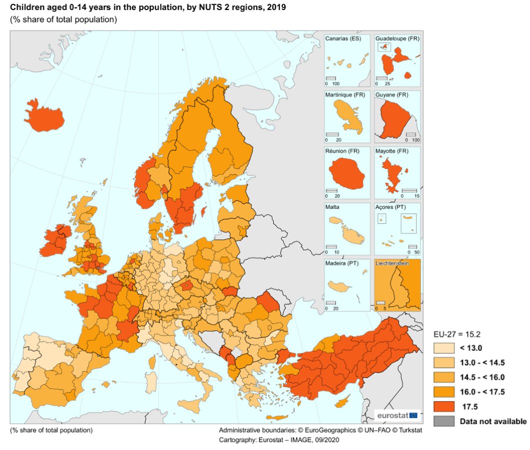
    This is interesting because it suggests that policies and cultural differences exist. For instance, you can stlll see East Germany and there is difference between eastern France and Western Germany, a difference that might not show up on other data, e.g. incomes might not be so different.

    EjJ4iKkXgAMByAJ?format=jpg


  • Registered Users, Registered Users 2 Posts: 1,749 ✭✭✭Smiles35


    This is interesting because it suggests that policies and cultural differences exist. For instance, you can stlll see East Germany and there is difference between eastern France and Western Germany, a difference that might not show up on other data, e.g. incomes might not be so different.


    13% is the base. All things being equal. 2 parents, 2 kids. Averege life expectancy 70. I'm looking at Spain and Italy. Now, Spain is known as retirement central. Not Italy though. Are Italians electing to have less children?

    Edit: Where does 2.4 children go on the percentage chart. My maths does not go that far. :)


  • Registered Users, Registered Users 2 Posts: 4,572 ✭✭✭KevRossi


    Smiles35 wrote: »
    13% is the base. All things being equal. 2 parents, 2 kids. Averege life expectancy 70. I'm looking at Spain and Italy. Now, Spain is known as retirement central. Not Italy though. Are Italians electing to have less children?

    Edit: Where does 2.4 children go on the percentage chart. My maths does not go that far. :)

    South of Spain is for retiring people. The paradox is that the south has more kids than the north of Spain.

    It doesn't even follow GDP per person in each autonomous community, so it's an interesting one.


  • Registered Users, Registered Users 2 Posts: 1,749 ✭✭✭Smiles35


    This is interesting because it suggests that policies and cultural differences exist. For instance, you can stlll see East Germany and there is difference between eastern France and Western Germany, a difference that might not show up on other data, e.g. incomes might not be so different.


    I would'nt spend too long on the France and Germany maps Charles. Sometimes the lads like that something is found that way.


  • Registered Users, Registered Users 2 Posts: 3,272 ✭✭✭Barna77


    KevRossi wrote: »
    South of Spain is for retiring people. The paradox is that the south has more kids than the north of Spain.
    More population down south. So more kids.
    Castilla y Leon in the northwest is roughly bigger than Andalucia but quite underpopulated in comparison


  • Registered Users, Registered Users 2 Posts: 23,031 ✭✭✭✭Tell me how


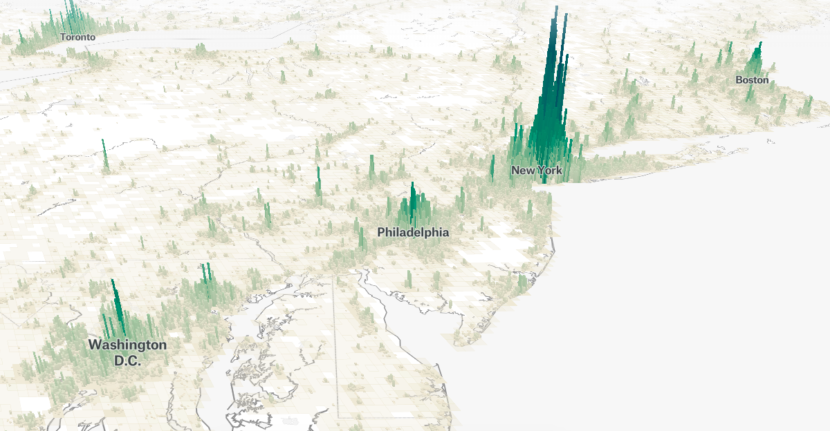
    This websites shows population density in 3D representation.

    https://pudding.cool/2018/10/city_3d/

    social_facebook.png

    Interesting concept but not sure if it is working correctly as in the few areas I checked, I didn't see significant changes in 2015 population versus 1990.


  • Registered Users, Registered Users 2 Posts: 5,182 ✭✭✭killbillvol2


    Barna77 wrote: »
    More population down south. So more kids.
    Castilla y Leon in the northwest is roughly bigger than Andalucia but quite underpopulated in comparison

    You really don't get percentages.


  • Registered Users, Registered Users 2 Posts: 1,749 ✭✭✭Smiles35


    EjJ4iKkXgAMByAJ?format=jpg


    Ireland {Leinster} has a large enough catchment of free ground around Dublin that people retiring/relocating don't go too far.


    Turkey?

    Option 1. They are micromanaging their population via industry as is Germany
    Option 2. They are doctoring their books.


  • Registered Users, Registered Users 2 Posts: 957 ✭✭✭BloodyBill


    chewed wrote: »
    So they invaded Iceland and Greece?

    Cool map. And Ireland as part of the UK until 1922 provided Generals and soldiers just Like Scotland, England and Wales. Ireland has invaded alot of places. Thats kinda cool


  • Advertisement
  • Registered Users, Registered Users 2 Posts: 3,272 ✭✭✭Barna77


    You really don't get percentages.

    Enlighten me


Advertisement