Advertisement
If you have a new account but are having problems posting or verifying your account, please email us on hello@boards.ie for help. Thanks :)
Hello all! Please ensure that you are posting a new thread or question in the appropriate forum. The Feedback forum is overwhelmed with questions that are having to be moved elsewhere. If you need help to verify your account contact hello@boards.ie

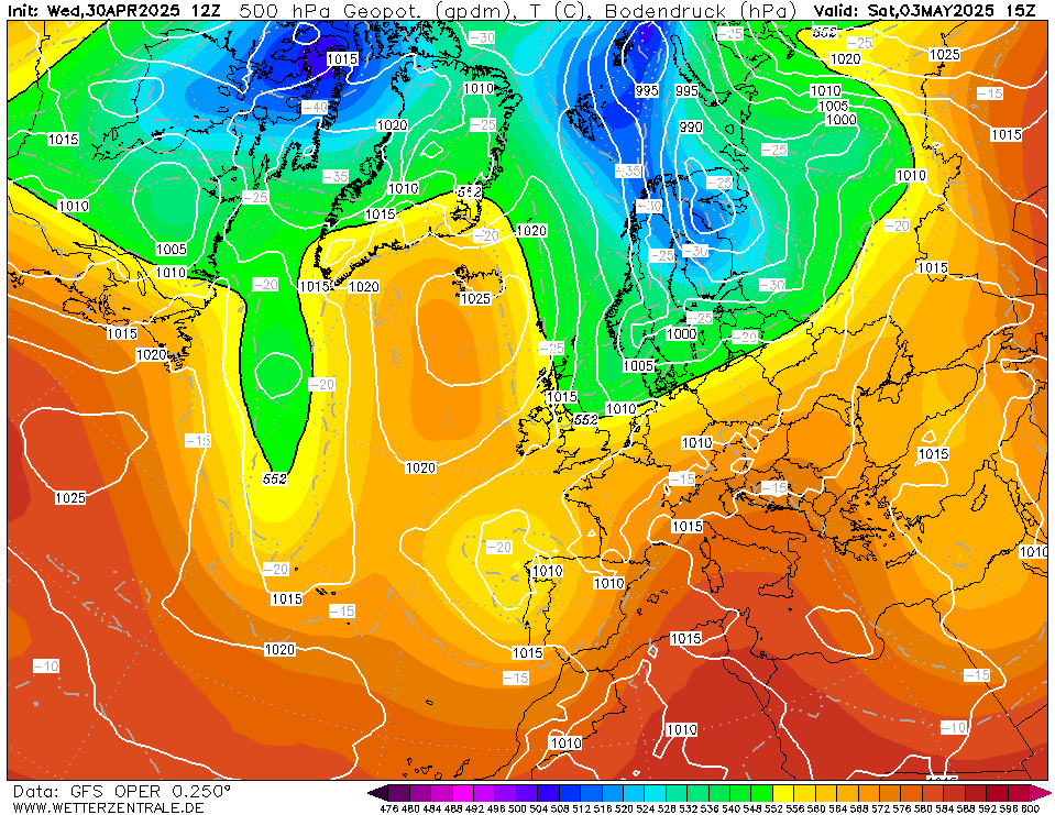
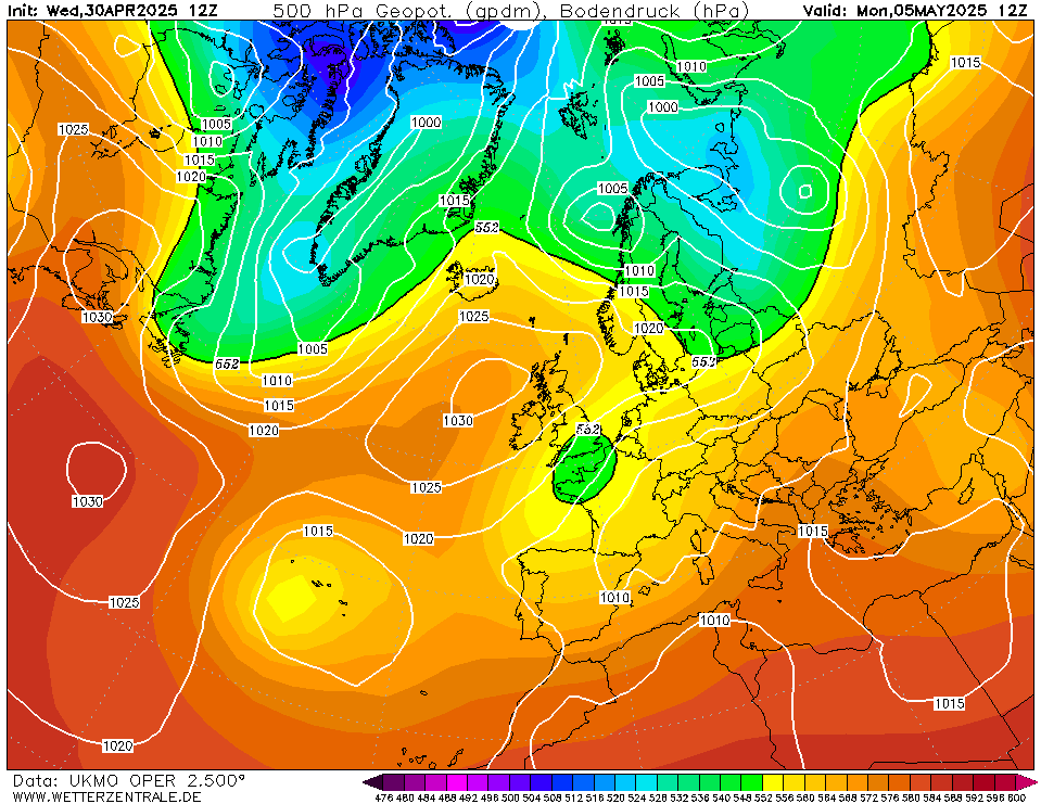
Greenland Express: Snow showers possible from Monday night

13468953

Comments

  • Registered Users, Registered Users 2 Posts: 17,604 ✭✭✭✭nacho libre


    "just get cold rain and sleet"...

    Now that seems familiar.

    I think this time we will have snow and some modest accuulations of snow will occur at lower levels. I would love if we all got 36 inches of snow that lasted for a few days. Although the mods might not as civil war might break out on here:)


  • Registered Users, Registered Users 2 Posts: 470 ✭✭catrat12


    Will the Dublin mountains see anything sorry for asking twice


  • Registered Users, Registered Users 2 Posts: 17,604 ✭✭✭✭nacho libre


    catrat12 wrote: »
    Will the Dublin mountains see anything sorry for asking twice

    There is nothing to be sorry for. I think, given the wind will be strong, the Dublin Mountains will see some snow. Errigal is the place to be though if you want to see a lot of snow on the ground. The Wicklow mountains will be good too.


  • Registered Users, Registered Users 2 Posts: 6,238 ✭✭✭Oneiric 3


    I think this time we will have snow and some modest accuulations of snow will occur at lower levels. I would love if we all got 36 inches of snow that lasted for a few days. Although the mods might not as civil war might break out on here:)

    Couldn't find a proper snow dance but here is the next best thing.


    Hopefully upon hearing the allure of this tune, that the skies will dance along accordingly.

    New Moon


  • Registered Users, Registered Users 2 Posts: 13,934 ✭✭✭✭sryanbruen


    Don't think it has gone above 10C in dublin all week!!

    I've had only one day this January so far with a maximum of 10c or more.

    Photography site - https://sryanbruenphoto.com/


  • Advertisement
  • Closed Accounts Posts: 240 ✭✭fraxinus1


    M.T. Cranium is more conservative these days because in the early days, he would talk up snow chances and often times we would just get cold rain or sleet. He tended to be influenced by the prevailing mood on here too.

    I can't fathom how someone can say winter is over already- unless you are engaging in reverse psychology?? You, as you have mentioned are longer in the tooth than i am, so you should know well that January and February is our optimum time for snow- just ask any farmer, if you don't believe me. So taking all this into consideration, i believe you are secretly doing a snow dance to the weather gods that we get snow next week.

    If a snow dance works, I would do one. I want snowfall. Even just for a day or two.


  • Closed Accounts Posts: 2,043 ✭✭✭George Sunsnow


    fraxinus1 wrote: »
    If a snow dance works, I would do one. I want snowfall. Even just for a day or two.

    But you’re in Donegal,the snowiest county in the planet :p


  • Registered Users, Registered Users 2 Posts: 25,109 ✭✭✭✭Kermit.de.frog


    Ok so where are we?

    On track.

    On Monday morning the northwest flow becomes well established quickly. Temperatures begin the day 6 - 10c country wide but will fall back through the afternoon. By early evening temperatures across the Northwest and North Midlands will be struggling to between 1 - 3c.

    Showers start early and become widespread quickly in a strengthening northwest wind. Showers will mainly be of rain through the afternoon but later (and quickly) they will start to transition to snow in the northwest and west. By nightfall settling snow is likely in the northwest and parts of the north midlands to low levels.

    GFSOPEU12_75_1.png

    GFSOPEU12_75_2.png

    Dew points by Monday evening

    78-101UK.GIF?12-12


    On Monday night snow showers are heavy and frequent in Connaught and Ulster spreading inland but lighter in the midlands and east (the flip side of this is the midlands and east will be the coldest regions with temps generally around freezing so any snow that makes it through will settle comfortably here). Munster may see more sleetiness for a while overnight. Temps slightly higher here - up to 3c.

    On Tuesday - it will be very cold with widespread heavy snow showers causing drifting and occasional blizzard like conditions in the west and north and the real possibility of some disruption in Leinster and Munster also through the day. Showers driven a long on a nigh on gale force Northwest wind. 2 - 6 cm over the east and south. 10 - 12 cm over the west and northwest.

    Temperatures 0 - 3c, warmest over Munster.

    UKMOPEU12_96_1.png

    102-574UK.GIF?12-12

    Snow and hail showers, widespread at times, continue Tuesday night. Wind will die back a little and so it will be very cold. Lows 0 - -3c (coldest in the east).

    Further widespread accumulations.

    On Wednesday morning and afternoon sleet and snow showers continue but will die out toward nightfall.

    Temperatures once more ranging 0 - 3c on Wednesday.

    Frontal system will approach from the Atlantic possibly Wednesday night and we need to watch this as it squares up to the embedded cold air over the country. Ripe conditions for snowfall particularly over the northern half of the country.

    UKMOPEU12_120_1.png

    We have to leave it here for the moment as there is uncertainty regarding the timing and extent of this incursion and it's overall effect. Key for snow is we don't want that to deepen too much, we want it just right.

    It will remain very cold.

    Wrap up!

    More later.


  • Moderators, Science, Health & Environment Moderators Posts: 4,508 Mod ✭✭✭✭mickger844posts


    I would be pleased enough with Kermits latest update. In Waterford City surprisingly we do quiet well with a NW flow. It wouldn't surprise me in the slightest to see at least a covering of some sorts IMBY. Fun times hopefully


  • Registered Users, Registered Users 2 Posts: 836 ✭✭✭derekon


    Hi Kermit, thanks for the post and the work you put in with charts etc.

    Just to check, would you agree with my view that the greater Dublin region will only get cold rain or at best, sleety showers with NO settling snow?

    D


  • Advertisement
  • Registered Users, Registered Users 2 Posts: 8,261 ✭✭✭Gaoth Laidir


    This back-trajectory plot shows the source and trajectory of the air arriving at Knock airport at midnight Tuesday night, plotted for two heights (50 (red) and 1500 (blue) metres amsl). So the airmass at Knock at midnight on Tuesday will have originated over Baffin Bay/northeastern Canada and taken a 3000-km sea track around the southern tip of Greenland towards us.

    Sea surface temperatures (click map to zoom in) between Greenland and New Foundland are around 3 °C, rising to around 9-11 °C from about 25W. This is a lot of scope for modification, so I don't think we'll see surface dewpoints much below zero by the time it arrives at our shores. Current dewpoints in the source area are around -30 °C.

    438492.gif

    Further north will always be slightly colder, further south warmer, but in such a convective setup, with the coldest uppers north of Ireland, it will be a rogue shower that produces 100% snow at lowest levels away from the far north imo.

    Now the other disturbance mentioned for Wednesday could be a different story.


  • Registered Users, Registered Users 2 Posts: 7,434 ✭✭✭pauldry


    Still looks like widespread wintry showers which at worst will bring continuous hail sleet and snow with some covering at times

    At best a blanket of snow Monday night in most parts of the North and West....n of course the rest of Ireland too


  • Moderators, Science, Health & Environment Moderators Posts: 17,403 Mod ✭✭✭✭Gonzo


    derekon wrote: »
    Hi Kermit, thanks for the post and the work you put in with charts etc.

    Just to check, would you agree with my view that the greater Dublin region will only get cold rain or at best, sleety showers with NO settling snow?

    D

    I think the main issue will be will the showers make it this far and how heavy will they be. Nighttime would be the greatest opportunity for lying snow but at night the showers tend to become more confined to the west and north. I still think it's currently too early to tell what will happen.


  • Registered Users, Registered Users 2 Posts: 25,109 ✭✭✭✭Kermit.de.frog


    derekon wrote: »
    Hi Kermit, thanks for the post and the work you put in with charts etc.

    No worries!

    Just to check, would you agree with my view that the greater Dublin region will only get cold rain or at best, sleety showers with NO settling snow?

    D

    I don't agree, I think Dublin will see snow from this and it's liable to settle in places as well particularly on Tuesday.


  • Closed Accounts Posts: 3,047 ✭✭✭Clonmel1000


    Well as someone with a daily 200km commute I really hope this doesn’t come to pass. I suspect it won’t but a couple of iffy days this week with ice frost and fog.


  • Registered Users, Registered Users 2 Posts: 17,604 ✭✭✭✭nacho libre


    fraxinus1 wrote: »
    If a snow dance works, I would do one. I want snowfall. Even just for a day or two.

    Prove it. You have turned your back on snow so many times here, i don't blame snow if it now turns its back on you:( :o

    ...but seriously you should see a bit of snow this week. I will hopefully be looking on enviously at the snow pictures on here next week.


  • Registered Users, Registered Users 2 Posts: 25,434 ✭✭✭✭Larbre34


    I'm afraid Kermits I don't agree with Kermits interpretation of the charts .

    MOD Changed the wording of your post

    In his selective chart posting, he omitted the upper level temp charts for any of the period under discussion, they never exceed -6C at 850, which would be marginal enough in an E/NE'ly situation, but in an atlantic system with a long fetch - albeit polar maritime - they are basically curtains for snow on all but high ground in the north west and north. What we are looking at is showery weather countrywide, passing hail, an irritating windchill feeling like 0-2 degrees, night frosts in sheltered parts and generally unpleasant to be outdoors in without being well wrapped up.

    In other words, don't get your kids hopes up over the weekend.


  • Registered Users, Registered Users 2 Posts: 25,109 ✭✭✭✭Kermit.de.frog


    Larbre34 wrote: »
    they never exceed -6C at 850

    Are you sure?

    I'm perfectly comfortable with the forecast and expect the warnings in due course.

    The hits are fine, makes people happier when it snows :)


  • Registered Users, Registered Users 2 Posts: 6,547 ✭✭✭munsterlegend


    It will be an interesting weeks weather anyway no matter what happens. We usually get plenty of precipitation from a north westerly here in north cork but it's usually of the very wet snow variety at best unless at high level so not expecting too much.


  • Registered Users, Registered Users 2 Posts: 17,604 ✭✭✭✭nacho libre


    Larbre34 wrote: »
    .

    In his selective chart posting, he omitted the upper level temp charts for any of the period under discussion, they never exceed -6C at 850, which would be marginal enough in an E/NE'ly situation, but in an atlantic system with a long fetch - albeit polar maritime - they are basically curtains for snow on all but high ground in the north west and north.

    In other words, don't get your kids hopes up over the weekend.

    That is not quite true in this scenario, the thickness factor and the dew points are on the right side in this situation, also while it is a long fetch, the wind could play a determining role this time in helping to both cool the water and hasten the track, which will help in reducing the modification factor. If the charts don't downgrade between now and monday, lower levels in the north and west will see snow. Philip Avery- the bbc forecaster- seems to think there will be snow next week as well. Wednesday looks interesting according to him for some northern areas.


  • Advertisement
  • Registered Users, Registered Users 2 Posts: 8,261 ✭✭✭Gaoth Laidir


    That is not quite true in this scenario, the thickness factor and the dew points are on the right side in this situation, also while it is a long fetch, the wind could play a determining role this time in helping to both cool the water and hasten the track, which will help in reducing the modification factor. If the charts don't downgrade between now and monday, lower levels in the north and west will see snow. Philip Avery- the bbc forecaster- seems to think there will be snow next week as well. Wednesday looks interesting according to him for some northern areas.

    Even the GFS has only a brief passing 520 dam thickness in the north late Tuesday, which is not quite the 516 I'd be hoping for to guarantee snow, except in the heaviest showers.

    The wind will not cool the sea by any amount, but it will hasten the track. Still, it has about 30 hours over waters from 3-11 °C. North will be best for low levels, but even then I would reckon only in the heaviest showers.

    Anyway, it is what it is. I hope to register more than I did this time last year...

    438428.jpg


  • Registered Users, Registered Users 2 Posts: 17,604 ✭✭✭✭nacho libre


    Even the GFS has only a brief passing 520 dam thickness in the north late Tuesday, which is not quite the 516 I'd be hoping for to guarantee snow, except in the heaviest showers.

    The wind will not cool the sea by any amount, but it will hasten the track. Still, it has about 30 hours over waters from 3-11 °C. North will be best for low levels, but even then I would reckon only in the heaviest showers.

    Anyway, it is what it is. I hope to register more than I did this time last year...

    438428.jpg

    You don't need 516 to get snow here, of course the lower the thickness the better, i have often seen snow in sub 528 dam thickness. As i keep saying i'm not expecting a foot of snow courtesy of a blizzard. So if that is your criteria for this then you will of course be right. I think we will get 2- 3 cms of snow at lower levels widely in the north west, i will concede that you were right in your analysis if this does not happen.


  • Banned (with Prison Access) Posts: 76 ✭✭Shedbebreezy


    You don't need 516 to get snow here, of course the lower the thickness the better, i have often seen snow in sub 528 dam thickness. As i keep saying i'm not expecting a foot of snow courtesy of a blizzard. So if that is your criteria for this then you will of course be right. I think we will get 2- 3 cms of snow at lower levels widely in the north west, i will concede that you were right in your analysis if this does not happen.

    Yes a dam line of 528 or below is required to see snow, just one of the ingredients. I won't be turning up my nose at anything below it.


  • Registered Users, Registered Users 2 Posts: 25,109 ✭✭✭✭Kermit.de.frog


    28241-giphy.gif


  • Registered Users, Registered Users 2 Posts: 8,261 ✭✭✭Gaoth Laidir


    You don't need 516 to get snow here, of course the lower the thickness the better, i have often seen snow in sub 528 dam thickness
    Yes a dam line of 528 or below is required to see snow, just one of the ingredients. I won't be turning up my nose at anything below it.

    528 will not cut it in a convective setup. 516 guarantees snow for us in such a case, 520 I would say 50:50. I wouldn't use this thickness in any other case as it becomes unreliable due to the effect of upper warm/moist layers.

    More reliable for snow is the 850-1000 thickness, which should be <1290, preferably 1280 metres for snow. The GFS has it 1300-1290 m at its lowest, which is more of a mixed precipitation scenario.


  • Banned (with Prison Access) Posts: 76 ✭✭Shedbebreezy


    528 will not cut it in a convective setup. 516 guarantees snow for us in such a case, 520 I would say 50:50. I wouldn't use this thickness in any other case as it becomes unreliable due to the effect of upper warm/moist layers.

    More reliable for snow is the 850-1000 thickness, which should be <1290, preferably 1280 metres for snow. The GFS has it 1300-1290 m at its lowest, which is more of a mixed precipitation scenario.

    I've had snow in a convective set up lots of times with that level. I must have imagined it.


  • Registered Users, Registered Users 2 Posts: 8,261 ✭✭✭Gaoth Laidir


    As i keep saying i'm not expecting a foot of snow courtesy of a blizzard. So if that is your criteria for this then you will of course be right. I think we will get 2- 3 cms of snow at lower levels widely in the north west, i will concede that you were right in your analysis if this does not happen.

    Blizzards have been mentioned, but I won't be expecting them either.

    But this is not a contest of who's right or wrong. Everyone has an opinion, and is entitled to it, but there are one or two new posters who seem to forget that. I hope the whole country gets pasted so Met Éireann can issue a nationwide RED, but I don't think that will happen either...:pac:


  • Registered Users, Registered Users 2 Posts: 8,261 ✭✭✭Gaoth Laidir


    I've had snow in a convective set up lots of times with that level. I must have imagined it.

    When was that, and where?


  • Registered Users, Registered Users 2 Posts: 17,604 ✭✭✭✭nacho libre


    528 will not cut it in a convective setup. 516 guarantees snow for us in such a case, 520 I would say 50:50. I wouldn't use this thickness in any other case as it becomes unreliable due to the effect of upper warm/moist layers.

    .

    I will respectfully have to disagree. Sub 528 thickness in past north westerly and northerly airflows has delivered snow for my area. I often recall having snow with 525- 520 dam thickness. I am not expecting powdery snow anyway. Wet snow will do fine. Given the dew points it should start accumulating monday night- the caveat being provided charts are not downgraded.


  • Advertisement
  • Registered Users, Registered Users 2 Posts: 17,604 ✭✭✭✭nacho libre


    Blizzards have been mentioned, but I won't be expecting them either.

    But this is not a contest of who's right or wrong. Everyone has an opinion, and is entitled to it, but there are one or two new posters who seem to forget that. I hope the whole country gets pasted so Met reann can issue a nationwide RED, but I don't think that will happen either...:pac:

    Well we can at least agree on that:D


This discussion has been closed.
Advertisement