Advertisement
If you have a new account but are having problems posting or verifying your account, please email us on hello@boards.ie for help. Thanks :)
Hello all! Please ensure that you are posting a new thread or question in the appropriate forum. The Feedback forum is overwhelmed with questions that are having to be moved elsewhere. If you need help to verify your account contact hello@boards.ie

Extratropical Storm Ophelia - Technical Analysis Only - MOD NOTE post #1

Options
1353638404189

Comments

  • Registered Users Posts: 23,566 ✭✭✭✭Kermit.de.frog


    I know MT has mention ICON but the GFS is not far behind in severity, track and depth.

    By any standard this is testing.

    gfs-0-48.png?12


  • Registered Users Posts: 2,777 ✭✭✭taytobreath


    Bus Eireann have cancelled their school buses Monday because of it.


  • Closed Accounts Posts: 2,988 ✭✭✭jacksie66


    This post has been deleted.


  • Registered Users Posts: 35,859 ✭✭✭✭BorneTobyWilde


    SO looks like Monday is cancelled.


  • Banned (with Prison Access) Posts: 2,986 ✭✭✭philstar


    Bus Eireann have cancelled their school buses Monday because of it.

    much to the disappointment of the drivers & pupils i bet


  • Advertisement
  • Registered Users Posts: 5,987 ✭✭✭TheMilkyPirate


    Interesting to note that Debbie in '61 had downgraded to a Cat-1 approaching the Azores, Ophelia upgraded to a Cat-3 approaching the same position.


  • Registered Users Posts: 14,388 ✭✭✭✭M.T. Cranium


    I think there's some confusion on the colour coding of gust speeds, the map shows output in knots but colour coding scale at the base of the map seems to be km/hr.

    The GFS compared to ICON shifts the maximum wind impact closer to the west coast although certainly there's a good rush of south to southwest gales into the midlands, and the portion of the west coast spared from storm force gusts is pushed back to a small part of Mayo (the ICON would say all of Mayo).

    The GEM looks about the same as previous runs, I don't think it has picked up on the more intense t=0 situation.

    Blending all this together I think it means about what the current warnings suggest with potential for pockets of severe damage in parts of west Munster. Timing the strongest winds for something like 10:00 to 13:00 on the south coast and in Kerry, to about 14:00 to 17:00 in Galway and midlands.

    Outcome for east coast still somewhat uncertain, could be anywhere from strong level one to marginal level three so level two the best bet.


  • Registered Users Posts: 2,910 ✭✭✭JanuarySnowstor


    I'd be pretty sure Met Eireann will expand the red alert shortly to cover most of South and West


  • Registered Users Posts: 15,862 ✭✭✭✭Discodog


    Looking at the track there is potential for a lot of downed trees. The winds could change by 180. So the trees get pushed all the way in one direction & then in the opposite. Perfect for snapping roots.

    I would advise people not to park near trees


  • Registered Users Posts: 6,162 ✭✭✭munsterlegend


    It will be travelling slightly slower than Debbie so I would not imagine we will see any worse winds than then.

    you are not one to hyperbole situations but if you are saying it may even come close to a once in generation event like Debbie then this is potentially a very noteeworthy event.


  • Advertisement
  • Closed Accounts Posts: 887 ✭✭✭Jobs OXO


    nagdefy wrote: »
    Holy Christ.. that's scary..really scary..

    Are there evacuation plans if required? The East seems likely to escape most of it


  • Banned (with Prison Access) Posts: 1,201 ✭✭✭Doltanian


    Discodog wrote: »
    Looking at the track there is potential for a lot of downed trees. The winds could change by 180. So the trees get pushed all the way in one direction & then in the opposite. Perfect for snapping roots.

    I would advise people not to park near trees

    Also park well away from buildings where falling slates and tiles will wreck your car.


  • Registered Users Posts: 6,162 ✭✭✭munsterlegend


    Interesting to note that Debbie in '61 had downgraded to a Cat-1 approaching the Azores, Ophelia upgraded to a Cat-3 approaching the same position.

    I think Debbie was travelling faster though. As other have said it will deintensify to a borderline Cat1 force but still interesting alright to see it's development.


  • Registered Users Posts: 23,566 ✭✭✭✭Kermit.de.frog


    I think there's some confusion on the colour coding of gust speeds, the map shows output in knots but colour coding scale at the base of the map seems to be km/hr.

    The GFS compared to ICON shifts the maximum wind impact closer to the west coast although certainly there's a good rush of south to southwest gales into the midlands, and the portion of the west coast spared from storm force gusts is pushed back to a small part of Mayo (the ICON would say all of Mayo).

    The GEM looks about the same as previous runs, I don't think it has picked up on the more intense t=0 situation.

    Blending all this together I think it means about what the current warnings suggest with potential for pockets of severe damage in parts of west Munster. Timing the strongest winds for something like 10:00 to 13:00 on the south coast and in Kerry, to about 14:00 to 17:00 in Galway and midlands.

    Outcome for east coast still somewhat uncertain, could be anywhere from strong level one to marginal level three so level two the best bet.

    +1

    Arpege out - I would class this timestamp as "dangerous" for the south west too.

    arpegeeur-0-48.png?12

    So still varying ideas on intensity to narrow down here.


  • Registered Users Posts: 9,233 ✭✭✭sdanseo


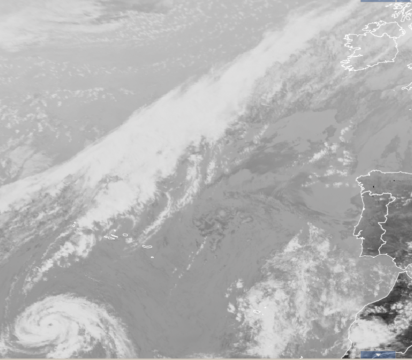
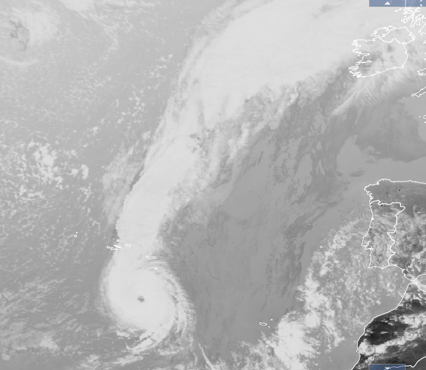
    Interesting - no, fascinating - to watch the progression of the storm on the satellite images from yesterday to today.
    http://eumetview.eumetsat.int/mapviewer/

    Yesterday 1500Z
    9b274d3af86e040e4ae800091cac0ea2.png

    Today 1500Z
    16c7848deadb41a2accc574227cac7f0.png


    Also a quote on the netweather forums that's worth a giggle:
    I always wanted to visit Ireland. Looks like I've missed my chance as it'll be gone by Tuesday morning.


  • Registered Users Posts: 9,922 ✭✭✭spookwoman


    Samaris wrote: »
    Been a bit focussed on there too - my home town. The bay opens right out into the direction of the storm, so I hope the prom is closed off - you know yourself what eejits are like for going and standing on it during storms. And I'd be a bit dubious of the amusement park as well, given its exposed position (and poor upkeep, at least when I lived there). I'd expect if there's damage it'll be places like The Atlantic, Majestic, Splashworld & whatever Celtworld/Storm is now and the apartments around there, plus Newtown and the part that dips down to the little pier near the Magic Well.

    Most of the town is well raised up anyway, so flooding is unlikely to be an issue. Not much protection from the wind though.
    I'd say the prom will be closed. Have to laugh at people driving down it during the bad storms. The amount of pebbles debris flying through the air is unreal and dangerous. Tides not too bad only a 3.8m at 3.45pm and depending on the direction of the wind it might not be the worst.
    I wonder if it could be another Christine with lumps of the road torn up around the end of the prom


  • Registered Users Posts: 23,369 ✭✭✭✭pjohnson


    As MT said, not much has changed in the forecast for Monday. People talking about evacuating the southwest need to calm down. A Cat 3 will not hit us.

    At the risk of repeating myself again, the current 100-knot intensity given by the NHC would equate to around 90 knots if this were a typical winter storm because of the difference between the windspeed classifications (1-minute Vs 10-minute). Knock around 11% off the NHC speeds to get the Beaufort speed. Now take that forward to Monday. 30-40 knots of weakening is very possible in the next 48 hours which would take it from its current 90 knots down to a more "survivable" 50-60 knots sustained winds, with of course higher gusts.

    Certainly a very notable and interesting event but please let's not lose the run of ourselves here. There is no need for evacuations.

    You seem very bloody knowledgeable so I'll stop being worried. That red warning thing was kinda scary.


  • Registered Users Posts: 96 ✭✭clawback07


    philstar wrote: »
    much to the disappointment of the drivers & pupils i bet

    I thought bus Eireann would only cancel school busses in the event of Met Eireann issuing a Status red warning . Having just checked Met Eireann fore cast they have not issued a red warning for Monday yet , or have I missed something ?


  • Registered Users Posts: 19,306 ✭✭✭✭Drumpot


    If it’s a Category 3 now, how are people certain it will be so much weaker by the time it might hit Ireland? Don’t these sort of fronts usually strengthen in sea? Or is it more related to the heat/energy they get depending on the conditions?

    I know it’s an odd event for seasoned weather followers but I’m not sure I understand if this is going to be a really bad event or just a windy day that’s because of unusual conditions?!


  • Registered Users Posts: 2,675 ✭✭✭Rougies


    But it says "noeuds" (knots)?

    The barbules(wind barbs) are in knots, the colours show km/h.


  • Advertisement
  • Registered Users Posts: 39,686 ✭✭✭✭Itssoeasy


    Jobs OXO wrote: »
    Are there evacuation plans if required? The East seems likely to escape most of it

    Why exactly would there need to be evacuation plans ? I've not read the whole thread but have I missed something ?


  • Registered Users Posts: 39,686 ✭✭✭✭Itssoeasy


    clawback07 wrote: »
    I thought bus Eireann would only cancel school busses in the event of Met Eireann issuing a Status red warning . Having just checked Met Eireann fore cast they have not issued a red warning for Monday yet , or have I missed something ?

    Met Eireann have issued a red warning

    http://www.met.ie/nationalwarnings/default.asp


  • Registered Users Posts: 9,233 ✭✭✭sdanseo


    Itssoeasy wrote: »
    Why exactly would there need to be evacuation plans ? I've not read the whole thread but have I missed something ?

    There was confusion over a chart that showed windspeed in knots but with a colour chart in km/h, leading a few of us to believe we were looking at ~280km/h gusts. Not the case.


  • Registered Users Posts: 23,566 ✭✭✭✭Kermit.de.frog


    https://www.cbsnews.com/news/hurricane-ophelia-track-path-latest-updates-uk-ireland/

    *rings*

    "Hi, hello, can you help me? I think I have woken up in a universe I don't recognise"


  • Registered Users Posts: 39,686 ✭✭✭✭Itssoeasy


    sdanseo wrote: »
    There was confusion over a chart that showed windspeed in knots but with a colour chart in km/h, leading a few of us to believe we were looking at ~280km/h gusts. Not the case.

    Thanks. I was looking at the word evacuations and saying had I missed a big warning.


  • Registered Users Posts: 1,351 ✭✭✭Cloudio9


    I'm assuming that's the eye of the storm you see along the west coast on the gust charts above. So will people along the west coast experience a short period of calm as the eye passes over them before it kicks off again?


  • Registered Users Posts: 8,219 ✭✭✭Gaoth Laidir


    15Z wind analysis, showing 89 knots 38 NM east of centre. The 64+ knot radius has further expanded to 80 NM to the southeast.

    2017AL17_MPSATWND_201710141500_SWHR.GIF


  • Registered Users Posts: 39,686 ✭✭✭✭Itssoeasy


    https://www.cbsnews.com/news/hurricane-ophelia-track-path-latest-updates-uk-ireland/

    *rings*

    "Hi, hello, can you help me? I think I have woken up in a universe I don't recognise"

    Well there you go lads. NBC and now CBS fecking news have used the words Hurricane and Ireland in the same sentence and it's not the 1st of April. This whole thing feels strange to me, but for the knowledgeable posters here this must be mental altogether.


  • Registered Users Posts: 160 ✭✭stevenup7002


    https://www.cbsnews.com/news/hurricane-ophelia-track-path-latest-updates-uk-ireland/

    *rings*

    "Hi, hello, can you help me? I think I have woken up in a universe I don't recognise"

    American headlines: CATEGORY 3 HURRICANE BARRELING TOWARDS IRELAND
    Irish headlines: Some buses might be canceled on Monday


  • Advertisement
  • Registered Users Posts: 9,233 ✭✭✭sdanseo


    15Z wind analysis, showing 89 knots 38 NM east of centre. The 64+ knot radius has further expanded to 80 NM to the southeast.

    Why is it that these analyses seem to be consistently less intense than the NHC's definition of maximum winds? Is it measured a different way or are they using different models?


Advertisement