Advertisement
If you have a new account but are having problems posting or verifying your account, please email us on hello@boards.ie for help. Thanks :)
Hello all! Please ensure that you are posting a new thread or question in the appropriate forum. The Feedback forum is overwhelmed with questions that are having to be moved elsewhere. If you need help to verify your account contact hello@boards.ie

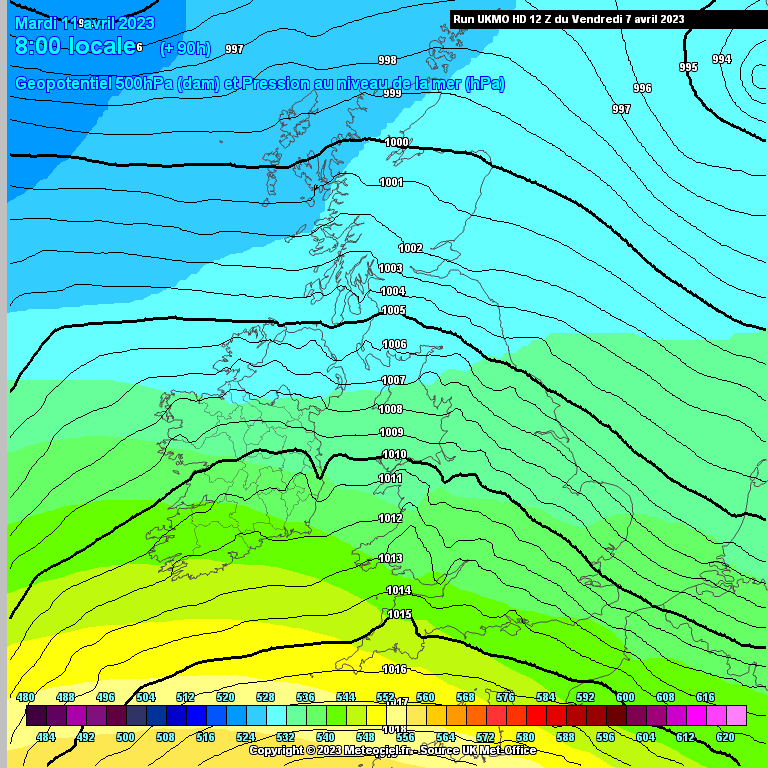
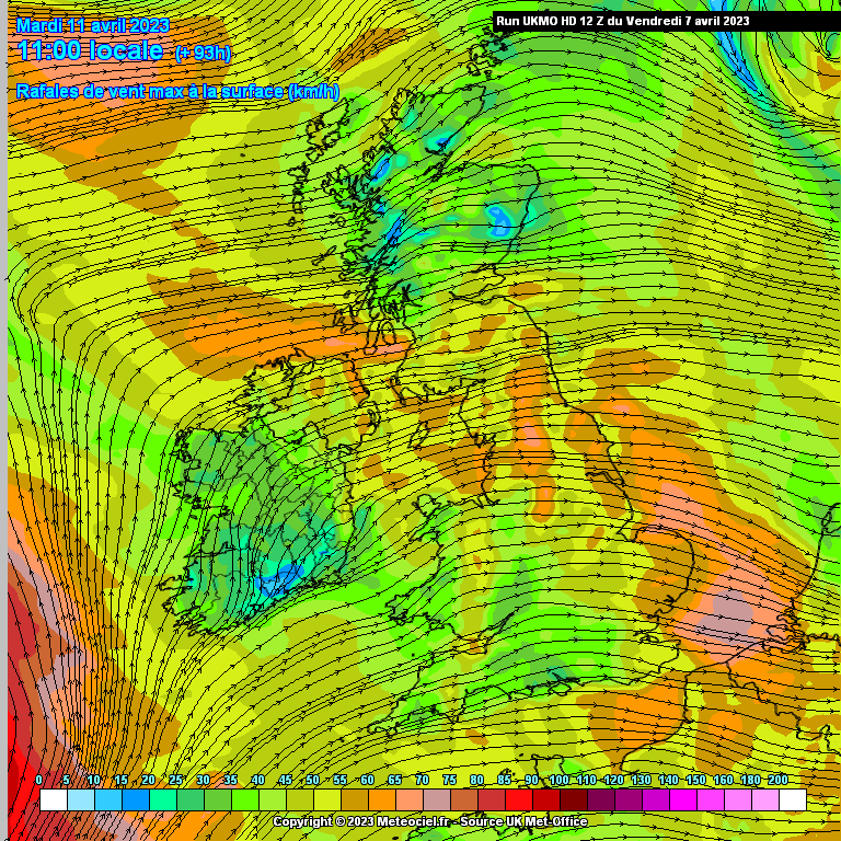
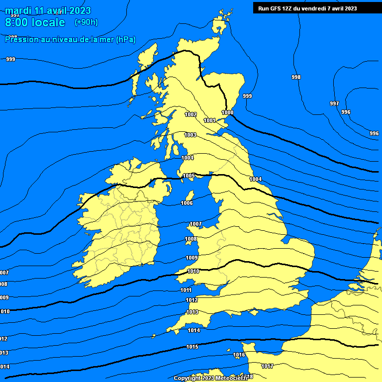
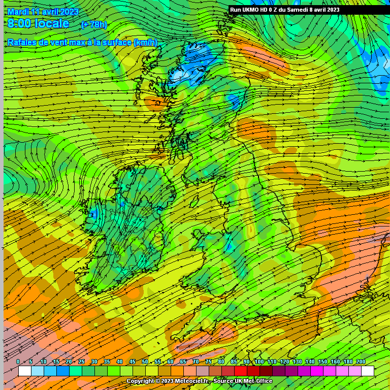
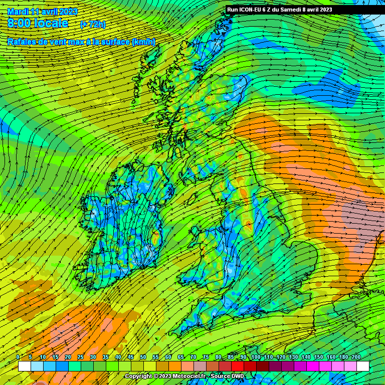
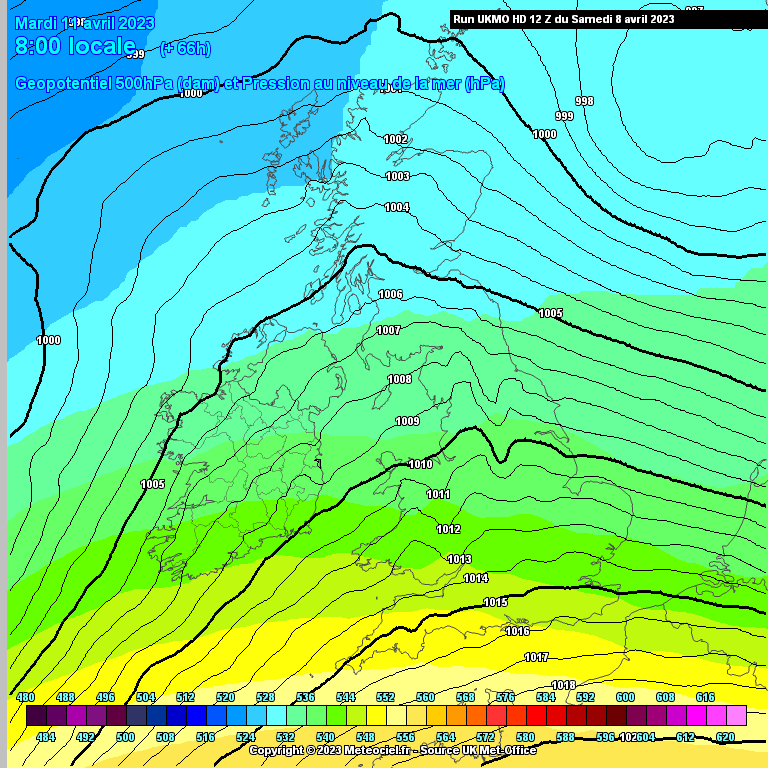
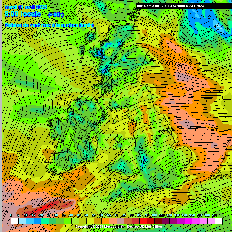
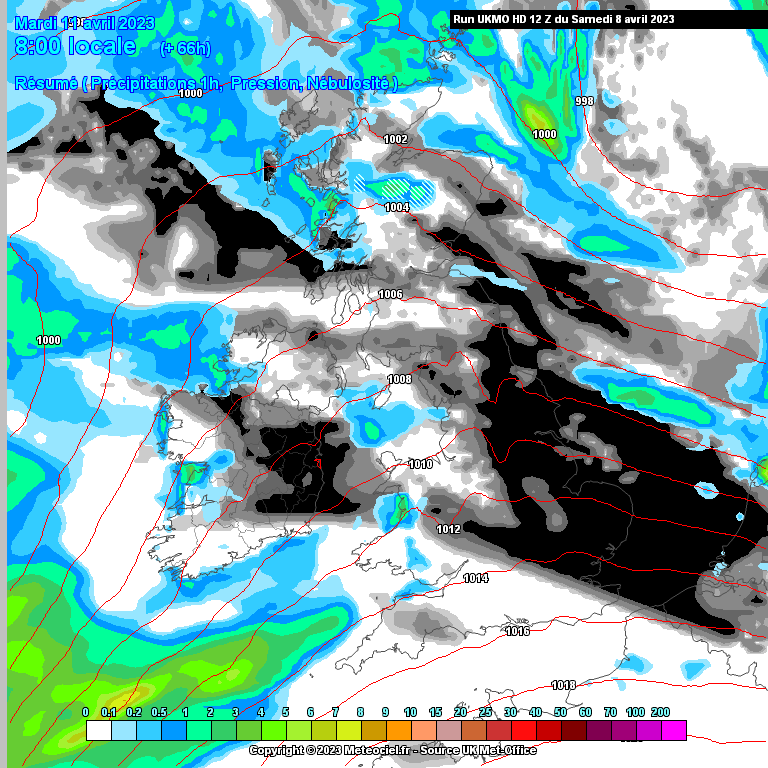
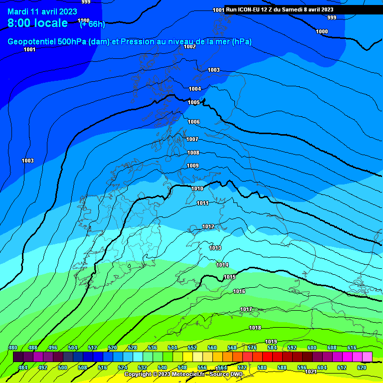
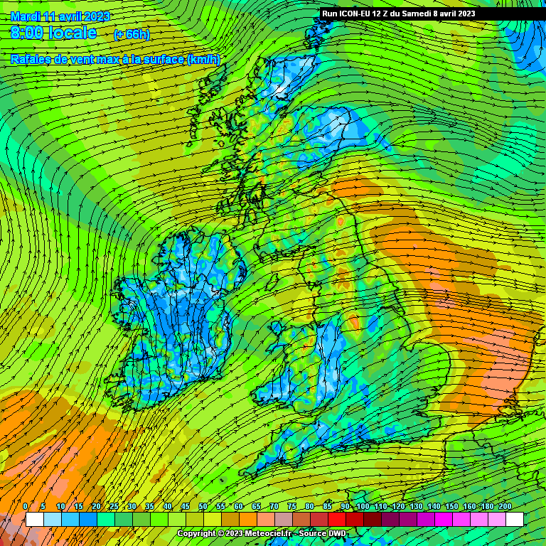
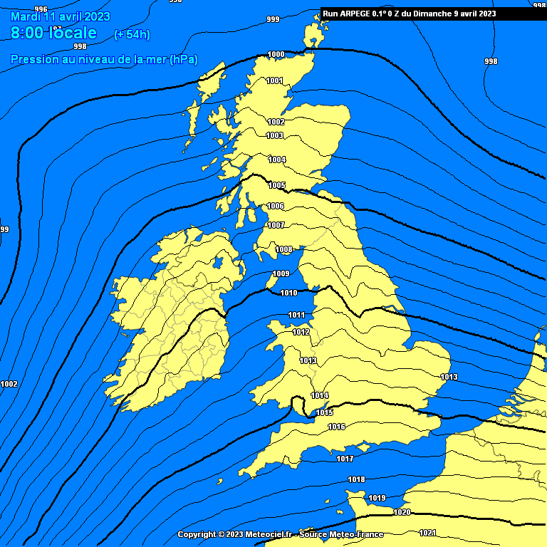
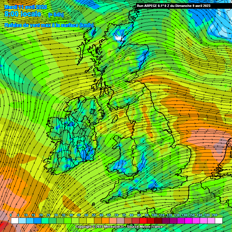
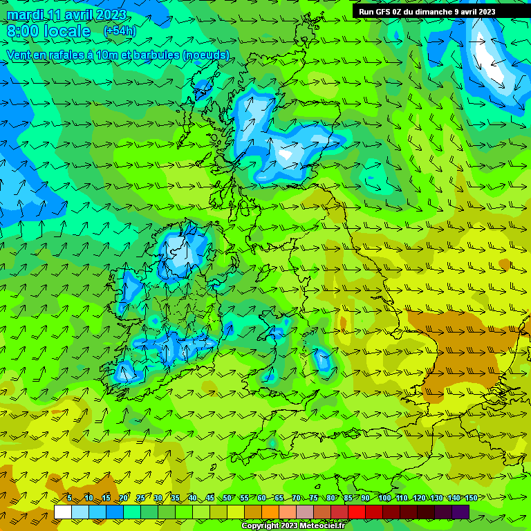
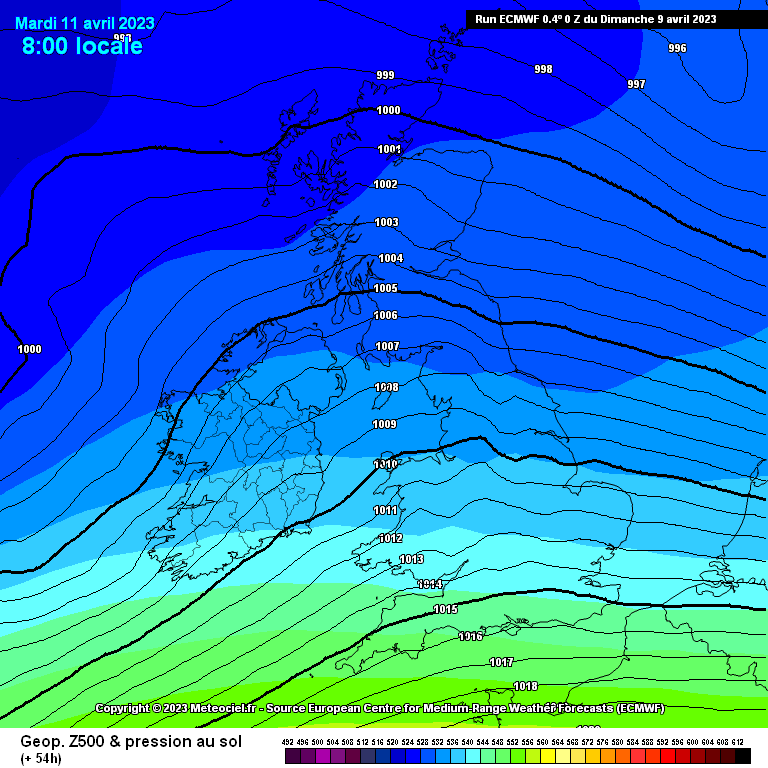
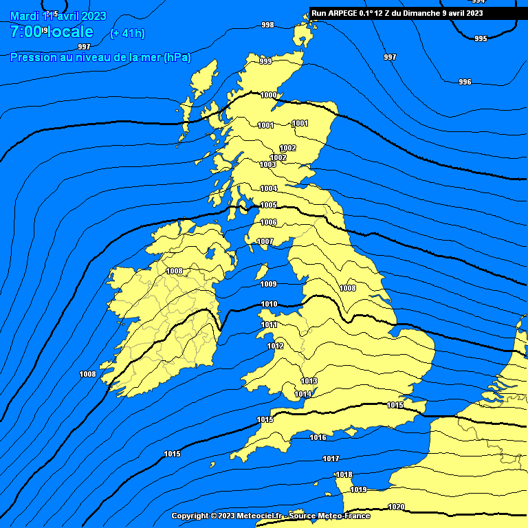
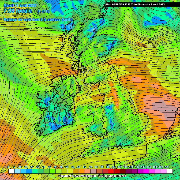
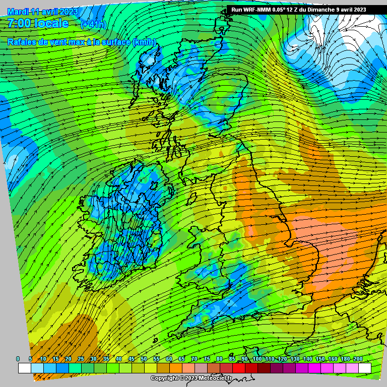
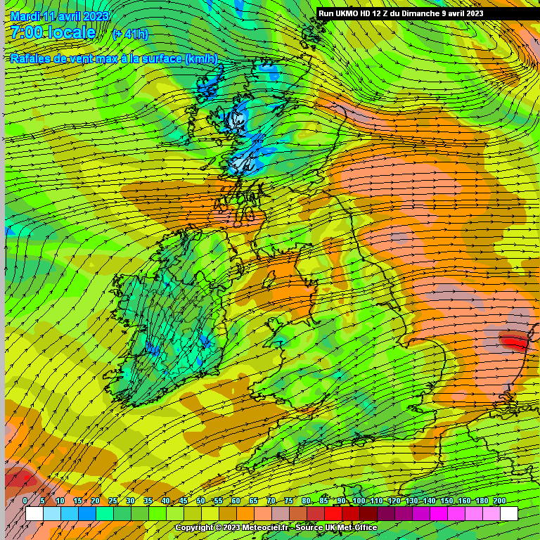
Tues 11th/ Weds 12th April 2023 strong winds, warnings likely.

Options
  • 07-04-2023 12:49pm
    #1
    Moderators, Science, Health & Environment Moderators Posts: 11,822 Mod ✭✭✭✭


    ECM about the most consistent I would think with track and wind speeds, GFS has eased off again on the 06Z, had been showing very strong winds on previous run- lot of chopping and changing, UKMO very strong and stormy overland but cant take it too literally this far out as prone to very much overdoing it in the early runs. ICON was consistent in its approach similar to the ECM if a lot stronger but has eased off on strength this morning and giving it a more ragged look with winds at different intervals. GEM a bit out on its own with a different look all together on latest run. Australian model showing a very strong wind event also.


    Can see that the storm deepens very rapidly and is still deepening at landfall. Taking a reading of probably about 1000 mb at 99hrs and 961hPa at 120hrs giving a drop of about 40mb in less than 24hrs. Formed along and exiting the left side of a very fast jet positioned to bring it close or over us. Fairly strong thermal gradient also brining in cold airs with it giving the chance of some wintry showers plus convective heavy showers with hail and will see if thunderstorms possible.

    Would think at this stage a fair chance of strong winds. Will see how the models progress with this.


    Just seen this on Met Eireanns site:

    TUESDAY: Wet and windy on Tuesday with wind warnings likely to be issued. There is potential for impactful conditions so stay up to date with the forecast for your local area.


    Post edited by Meteorite58 on


«1345

Comments

  • Registered Users Posts: 23,814 ✭✭✭✭Larbre34


    Well, it wouldn't be a US Presidential visit without a storm coming.

    Now all we need is an Icelandic Volcano ash plume and it'll be Obama 2011 all over again.


  • Registered Users Posts: 1,744 ✭✭✭.Donegal.


    Looking at the ecm ensemble for Malin beg right on the coast in west Donegal. One run had a gust of 164kmh but the main run was above the mean.

    For Belmullet main run has a gust of 132kmh which is also above the mean. One has 150kmh.

    For Dublin main run 84kmh above the mean of 71kmh. Max is 110kmh.

    Some stormy potential at long last.


  • Registered Users Posts: 6,458 ✭✭✭SouthWesterly


    Would you all go away with your warnings. Please.🫣😁

    Was in the garden today planting spuds and off all next week with a heap to do outside.


  • Registered Users Posts: 295 ✭✭Robwindstorm


    Amazing if it were to materialize. Not sure of the April windspeed record but as someone said Obama came during a May storm but I don't think it was too bad. I think met eireann are being careful with this one and rightly so because there's still Easter holidays with kids play dates etc. This set up usually doesn't come to pass as severe as forecast particularly given the time of year but the ingredients are certainly there. Well done meteorite for seeing this potential a couple of days back when everyone is slacking of chart watching until summer heat or thunderstorms come back in to play. Interesting to watch this play out.


  • Moderators, Science, Health & Environment Moderators Posts: 11,822 Mod ✭✭✭✭Meteorite58


    UKMO is unrelenting in its depiction of what this might look like although could easily be still overdoing it at this stage, ICON back looking like ECM and UKMO, will see what the ECM looks like shortly. Still too soon to know exactly how strong or exact tract.


  • Advertisement
  • Moderators, Science, Health & Environment Moderators Posts: 11,822 Mod ✭✭✭✭Meteorite58


    ECM just rolling out and has a different look and shape and not as strong on this run, maybe an outlier compared to the previous runs. Looks like forming that bit later and deepening as it has moved pass Ireland so to speak. Less deep also. Will just have to wait and see. GFS still keeping a smaller version to the South of us keeping the strongest winds offshore. So a big spread again.

    ARPGE 12Z Just getting there and showing a deepening storm moving into the SW with strong winds but too early for this model just yet.


  • Registered Users Posts: 1,490 ✭✭✭typhoony


    Very much doubt we'll get a storm mid-week this time of year, could get a bit squally on Monday though in the showers


  • Moderators, Home & Garden Moderators, Science, Health & Environment Moderators Posts: 17,710 Mod ✭✭✭✭DOCARCH


    Met Eireann' current thoughts:

    There is a low probability of a high impact event on Tuesday and into Wednesday. While there is still a high degree of uncertainty in the details it is quite likely that Tuesday will be a wet and windy day with the possibility of wind warnings being issued in due course.

    ** There is potential for impactful conditions, so stay up to date with the forecast and warnings for your local area **.


  • Registered Users Posts: 1,831 ✭✭✭adocholiday


    ECM has backed off the stronger winds now in the last 2 runs, still windy but nothing major. GFS has the system well to our South heading towards Cornwall so a non-event, and the UKMO doing similar also downgrading the wind strength. Still a lot of uncertainty in the models but all trending away from the strong winds showing in earlier runs.


  • Registered Users Posts: 6,880 ✭✭✭pauldry


    Ya it looks like deepening over Britain. Nothing much here but it may be a named storm because its impacting Britain.

    Our media will blow it out of all proportion probably and people will say "that's not a storm".


  • Advertisement
  • Registered Users Posts: 33,005 ✭✭✭✭NIMAN


    Looks like we took a bad time to do a family visit to Dublin Tuesday to Thursday!


  • Registered Users Posts: 606 ✭✭✭RedPeppers


    With the help of God it stays well away. Its bloody spring time and the weather has been deplorable up to now.


  • Moderators, Science, Health & Environment Moderators Posts: 16,716 Mod ✭✭✭✭Gonzo


    Hopefully this storm doesn't amount to anything here. This Spring has been awful with the exception of 2 or 3 days where it hasn't been raining and we're nearly half way through Spring.


  • Moderators, Science, Health & Environment Moderators Posts: 11,822 Mod ✭✭✭✭Meteorite58


    It turns out the GFS has been the most consistent of the models this far bringing the system mainly into the UK. ECM has lost all its shape and consistency with this and is undergoing new processing of the data. UKMO changing the look of it, still showing quite windy weather at times, ICON had totally eased off but back showing something stronger this morning. ARPEGE ( on the 06Z brushing off the S , SE of Ireland ) more like the GFS.

    The Jet looks to be taking a more Southerly direction so the energy/ system seems to be following a similar route. We haven't seen how this will finally look but for now anyway the threat of a severe storm is greatly diminished, still a chance of strong winds for a time and also it is possible that there will be heavy rain for a time, but even now hard to know how this will pan out .


  • Registered Users Posts: 6,458 ✭✭✭SouthWesterly


    So that means the sun will be shining and I can get some gardening done....right ?🫣


  • Registered Users Posts: 1,985 ✭✭✭Artane2002


    Sunshine and showers possibly turning wintry in heavier bursts, especially on higher ground


  • Registered Users Posts: 895 ✭✭✭KanyeSouthEast


    I’d say you’ll be fine somehow. This is probably being blown out of all proportion again. I wouldn’t be cancelling or changing plans if I was you


  • Moderators, Science, Health & Environment Moderators Posts: 11,822 Mod ✭✭✭✭Meteorite58


    It isn't over yet according to the latest UKMO, deepening system crossing Ireland brining very strong winds and some heavy falls of rain. Still not seeing the finished article though, chopping and changing to come . ICON showing stronger winds now also but not as strong as the UKMO, will see what the ECM offers later. GFS 12Z still more or less the same track but possibly not as strong

    Met Office still mentioning the potential and the uncertainty.


  • Moderators, Science, Health & Environment Moderators Posts: 11,822 Mod ✭✭✭✭Meteorite58


    Actually the ICON 12Z much stronger than the 06Z and taking a similar route as the UKMO, different shape to it but the potential there for something quite windy now .

    The GFS ARPEGE not showing it to such extent.

    ECM back looking a bit more organised with two areas of Lp deepening/ merging but in a different place again , stronger winds but nothing extreme on this run.

    Plenty of changeable charts to come, probably the hardest to model when formed of the Jet like that.


  • Registered Users Posts: 1,831 ✭✭✭adocholiday


    The one thing about Icon, in my experience, is it always overcooks the winds. In my last 3 years following weather closely I don't remember it ever being right with strong wind events.


  • Advertisement
  • Moderators, Science, Health & Environment Moderators Posts: 11,822 Mod ✭✭✭✭Meteorite58


    There is no doubt it over does the wind speeds some bit as does the UKMO. Lower again on the 18Z run from ICON.


  • Registered Users Posts: 6,880 ✭✭✭pauldry


    Even if the midweek storm misses us there are many near misses throughout April as the jet livens.

    Could be an unsettled Summer with El Nino returning.


  • Moderators, Science, Health & Environment Moderators Posts: 11,822 Mod ✭✭✭✭Meteorite58


    More changes in the model output this morning. ARPEGE, GFS looking very windy at times Tues and Weds, UKMO's track takes the strongest winds offshore but windy also at times in places Weds, ICON windy Weds, ECM windy Weds but not extreme.

    So GFS and ARPEGE have shifted the track of the system, which they are showing to be a complex arrangement of two areas of LP deepening over Ireland, ARPEGE at this stage keeping two center's whereas the GFS shows them to merge but both showing similar winds up there in the high Yellow and into Orange warning level but all subject to change.

    Certainly no cross model agreement ,ECM , ICON and UKMO would have to come more inline to have any certainty but I would think that they are heading towards some spells of windy if not very windy weather.


  • Registered Users Posts: 24,281 ✭✭✭✭lawred2


    Flying Edinburgh Dublin on Tuesday afternoon. This doesn't sound great for that.


  • Registered Users Posts: 1,744 ✭✭✭.Donegal.


    Wind warning issued for Antrim and Down for Tuesday. In the notes it mentions gusts of up to 60mph so nothing too bad. With the uncertainty, that warning will probably be modified in some way by tomorrow.


  • Registered Users Posts: 16,639 ✭✭✭✭nacho libre


    It depends what type of El Nino it is. If it's a strong one that's usually bad news if you want good weather. However a moderate to weak one can lead to settled conditions. Back to the present, I would like a storm, it has been too long since we've had a proper storm, but it looks like we will miss out again


  • Registered Users Posts: 12,778 ✭✭✭✭ninebeanrows


    A lot unresolved on this system


    12zs be interesting


  • Registered Users Posts: 1,981 ✭✭✭squarecircles


    Yes for a moment there it looked like we might have had a weather event...must be the most protracted blandest period of non weather in some time.


  • Moderators, Science, Health & Environment Moderators Posts: 11,822 Mod ✭✭✭✭Meteorite58


    Cant ignore how strong some of the models look on the latest runs but still not resolved, ECM will tell a lot soon. Probably one of the hardest things to model when an area of LP drops like a stone coming off the Jet . It would seem there is an area of LP forming rapidly with a wave off it forming rapidly also into another area of LP which in turn deepens rapidly. The two areas of LP more or less tied together and pirouetting around each other and possibly/ probably merging into a larger area of Lp in the end. So the timing strength, track is changing quite a bit but perhaps starting to see what this might resemble Tue /Weds.

    ARPEGE, UKMO are showing storm force winds along coastal counties and overland. WRF- NMM very strong winds overland, GFS strong winds overland, ICON down on Tues but strong on Weds overland. ECM out shortly , earlier was showing bouts of windy conditions in the Yellow range.

    So potential for a wind event with warnings of at least in the Orange level at times, widespread yellow. Hard one to forecast as there will be periods of strong winds, cyclonic in nature so coming from different directions.

    Some heavy rain at times also and wind driven to boot. Very cold uppers so convective showers with hail and thunderstorms possible and maybe a bit wintry on high ground / Mountains.


  • Advertisement
  • Moderators, Recreation & Hobbies Moderators Posts: 11,088 Mod ✭✭✭✭igCorcaigh


    Ooh... I'm no expert but that convergence of LPs and the twisty winds might produce localised surprises? More mini tornados or stingjets possible perhaps?😮


Advertisement