Advertisement
If you have a new account but are having problems posting or verifying your account, please email us on hello@boards.ie for help. Thanks :)
Hello all! Please ensure that you are posting a new thread or question in the appropriate forum. The Feedback forum is overwhelmed with questions that are having to be moved elsewhere. If you need help to verify your account contact hello@boards.ie

Interesting Maps

Options
19192949697236

Comments

  • Registered Users Posts: 413 ✭✭chosen1


    Brian? wrote: »
    Can you navigate the Royal canal in to the Royal Canal basin? I thought some parts around Cabra were filled in.

    I cycled much of the Royal Canal a couple of years ago and it wasn't navigatable at all in my opinion. This was September after a fairly dry summer and there was very little water in it in many parts. They were pumping water from rivers into it in places.

    Might be different now or during winter when there's plenty of rain.


  • Registered Users Posts: 14,022 ✭✭✭✭retalivity


    Brian? wrote: »
    Can you navigate the Royal canal in to the Royal Canal basin? I thought some parts around Cabra were filled in.

    There's none filled in afaik, but you never see any boats on it within Dublin city, compared to the grand canal. Maybe the locks are locked or something


  • Moderators, Recreation & Hobbies Moderators, Science, Health & Environment Moderators, Technology & Internet Moderators Posts: 90,760 Mod ✭✭✭✭Capt'n Midnight


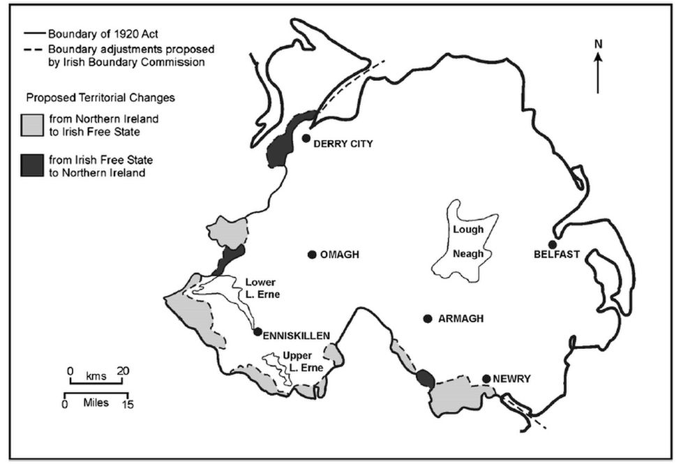
    _118158953_bcproposalmap.png

    one suggested border alignment
    The commission considered Newry's port revenues, coal supply infrastructure, and decided the town was too important to Northern Ireland's linen industry to transfer south.

    "This was the archetypal case study of economic and geographic conditions overriding the wishes of the inhabitants,"


  • Moderators, Category Moderators, Arts Moderators, Sports Moderators Posts: 48,446 CMod ✭✭✭✭magicbastarder


    i had never noticed before that google maps doesn't show county borders in northern ireland. it does for the rest of the island.


  • Registered Users Posts: 413 ✭✭chosen1


    i had never noticed before that google maps doesn't show county borders in northern ireland. it does for the rest of the island.

    They are only ceremonial up there nowadays and have no official use since the 70s.

    They were replaced by councils centred around the bigger towns and Fermanagh Council was the only one to be left in it's traditional entirety. Even that is gone now since they streamlined them again into larger "super councils" and parts of Tyrone were emalgamated with it.

    Only real place they use the traditional 6 counties is for GAA purposes these days so that's why you won't see them on official maps.


  • Advertisement
  • Registered Users Posts: 5,660 ✭✭✭The J Stands for Jay


    chosen1 wrote: »
    Also half of the towns of Athlone and Ballinasloe are in Co. Roscommon in that map.

    They changed county boundaries when urban district councils were established in the 1890s and parts of towns were transferred to the county of the bigger part of the town.

    Similar thing happened with parts of Drogheda previously in Meath and are other examples around Ireland too.

    A friend of mine has his postal address as Drogheda, Co Meath.


  • Registered Users Posts: 413 ✭✭chosen1


    McGaggs wrote: »
    A friend of mine has his postal address as Drogheda, Co Meath.

    There are newer estates to the south of Drogheda who are in Co. Meath today, outside of the 1890s border.

    However previous to that, the Boyne was the county boundary so there were several town centre streets that would have been in Meath also.


  • Registered Users Posts: 78,267 ✭✭✭✭Victor


    Brian? wrote: »
    Can you navigate the Royal canal in to the Royal Canal basin? I thought some parts around Cabra were filled in.
    You can navigate all the way from the Shannon to the Liffey.

    However, the lifting bridge at Newcomen Bridge is only open to canal traffic on a few days per year. https://www.bing.com/maps?osid=03bddaa8-56f5-498c-bfc2-a1f688ca0c8f&cp=53.356415~-6.243403&lvl=21&dir=90&style=g&v=2&sV=2&form=S00027

    The original line to Broadstone, except for Blessington Street Basin, was filled in and is now a park. https://www.bing.com/maps?osid=a58dfe81-7c51-4a34-8907-0c765348347b&cp=53.357573~-6.271755&lvl=18&style=h&v=2&sV=2&form=S00027


  • Registered Users Posts: 13,645 ✭✭✭✭josip


    Brian? wrote: »
    All of the Dutch people I know say Holland when speaking English, that was my point. I don't have conversations in Dutch.

    Is that the same as people who translate the names of their cities into English if speaking to an Anglophone?
    eg. Swedish who would use Gothenberg instead of Goteborg.


  • Registered Users Posts: 8,513 ✭✭✭blackwhite


    Brian? wrote: »
    Can you navigate the Royal canal in to the Royal Canal basin? I thought some parts around Cabra were filled in.

    A spur that went down towards Broadstone was filled in. Still very visible on google maps as a green strip running from behind Mountjoy Prison down to Broadstone.
    Blessington St Basin is the only undrained part of that spur remaining.

    Royal Canal Bank is the street that runs most of the length of it


  • Advertisement
  • Moderators, Recreation & Hobbies Moderators Posts: 20,825 Mod ✭✭✭✭Brian?


    Victor wrote: »
    You can navigate all the way from the Shannon to the Liffey.

    However, the lifting bridge at Newcomen Bridge is only open to canal traffic on a few days per year. https://www.bing.com/maps?osid=03bddaa8-56f5-498c-bfc2-a1f688ca0c8f&cp=53.356415~-6.243403&lvl=21&dir=90&style=g&v=2&sV=2&form=S00027

    The original line to Broadstone, except for Blessington Street Basin, was filled in and is now a park. https://www.bing.com/maps?osid=a58dfe81-7c51-4a34-8907-0c765348347b&cp=53.357573~-6.271755&lvl=18&style=h&v=2&sV=2&form=S00027

    I've done the Shannon a couple of times and the Shannon-Erne once. Parts of the Grand Canal and parts of the Barrow.

    A dream of mine is to sail up the Grand Canal and back the Royal Canal. Or vice versa.

    they/them/theirs


    And so on, and so on …. - Slavoj Žižek


  • Registered Users Posts: 40,165 ✭✭✭✭ohnonotgmail


    McGaggs wrote: »
    A friend of mine has his postal address as Drogheda, Co Meath.

    my sister lives in drogheda and her address is co. meath.


  • Registered Users Posts: 2,979 ✭✭✭Stovepipe


    Brian? wrote: »
    I've done the Shannon a couple of times and the Shannon-Erne once. Parts of the Grand Canal and parts of the Barrow.

    A dream of mine is to sail up the Grand Canal and back the Royal Canal. Or vice versa.

    A lot of the locks in the Dublin area are not usable by deliberate or accidental neglect. Compared to the locks further out, they are effectively not included in the system and passage is not encouraged.


  • Registered Users Posts: 13,852 ✭✭✭✭Zebra3


    chosen1 wrote: »
    They are only ceremonial up there nowadays and have no official use since the 70s.

    They were replaced by councils centred around the bigger towns and Fermanagh Council was the only one to be left in it's traditional entirety. Even that is gone now since they streamlined them again into larger "super councils" and parts of Tyrone were emalgamated with it.

    Only real place they use the traditional 6 counties is for GAA purposes these days so that's why you won't see them on official maps.

    Same with Co. Dublin. Doesn't exist any more in the state.


  • Registered Users Posts: 10,150 ✭✭✭✭Hurrache


    Every recorded battle in history apparently based on those referenced in Wikipedia

    E0gYrJSXEAIaNqf?format=jpg&name=large


    https://twitter.com/SonerCagaptay/status/1389387850551005192


  • Registered Users Posts: 13,645 ✭✭✭✭josip


    First of hundreds of questions.
    What happened in Perth/Freemantle apart from a prison riot?


  • Registered Users Posts: 40,165 ✭✭✭✭ohnonotgmail


    2nd of hundreds of questions: are we really expected to believe there were so few battles recorded in china and india?


  • Posts: 18,749 ✭✭✭✭ [Deleted User]


    That battle map is excellent, very interesting to see the different countries taking over.....


  • Registered Users Posts: 2,895 ✭✭✭Brief_Lives


    wow... that youtube vid is unreal....
    the coments underneath are hilarious too....

    "every country in Europe: War War War !!!!!!
    Switzerland: Ah tea time, right"

    "1790’s to 1810’s:
    Napoleon: allow me to introduce myself"


  • Advertisement
  • Registered Users Posts: 2,895 ✭✭✭Brief_Lives


    josip wrote: »
    First of hundreds of questions.
    What happened in Perth/Freemantle apart from a prison riot?

    https://en.wikipedia.org/wiki/Emu_War

    mentioned in the comments underneath...


  • Moderators, Recreation & Hobbies Moderators, Science, Health & Environment Moderators, Technology & Internet Moderators Posts: 90,760 Mod ✭✭✭✭Capt'n Midnight


    2nd of hundreds of questions: are we really expected to believe there were so few battles recorded in china and india?

    Wikipedia is very US centric. Every incident in War of Independence and action during Korean war would rate as highly as Stalingrad or Kursk.


  • Registered Users Posts: 14,359 ✭✭✭✭Professor Moriarty


    https://en.wikipedia.org/wiki/Emu_War

    mentioned in the comments underneath...

    Wonder what kind of weapons the emus used.


  • Registered Users Posts: 40,165 ✭✭✭✭ohnonotgmail


    Wonder what kind of weapons the emus used.

    they only had their cunning and wit which is why they won. The aussies were no match for them.


  • Posts: 0 [Deleted User]


    they only had their cunning and wit which is why they won. The aussies were no match for them.

    If the EMU were willing to stoop to use their cunning and wit against them you can see how the aussies were going to fail. Their Vietnam.


  • Registered Users Posts: 40,165 ✭✭✭✭ohnonotgmail


    Wikipedia is very US centric. Every incident in War of Independence and action during Korean war would rate as highly as Stalingrad or Kursk.

    while using wikipedia as a source is problematic they didn't even do that right. There are 2 dots in New Zealand when there were at least 8 separate wars between the british and the maori over a period of more than 25 years. the map is nonsense and the guy who tweeted it teaches history. He should be embarrassed.


  • Registered Users Posts: 40,165 ✭✭✭✭ohnonotgmail


    If the EMU were willing to stoop to use their cunning and wit against them you can see how the aussies were going to fail. Their Vietnam.

    the aussies struggled against amphibians, they had no chance against mammals.


  • Registered Users Posts: 14,359 ✭✭✭✭Professor Moriarty


    the aussies struggled against amphibians, they had no chance against mammals.

    Actually, if they put a couple of emus out on the wings they might do a lot better against the All Blacks.


  • Registered Users Posts: 40,165 ✭✭✭✭ohnonotgmail


    Actually, if they put a couple of emus out on the wings they might do a lot better against the All Blacks.

    Ouch.


  • Advertisement
  • Registered Users Posts: 14,359 ✭✭✭✭Professor Moriarty


    Ouch.

    The truth always hurts.


Advertisement