Advertisement
If you have a new account but are having problems posting or verifying your account, please email us on hello@boards.ie for help. Thanks :)
Hello all! Please ensure that you are posting a new thread or question in the appropriate forum. The Feedback forum is overwhelmed with questions that are having to be moved elsewhere. If you need help to verify your account contact hello@boards.ie

Interesting Maps

Options
16667697172238

Comments

  • Registered Users Posts: 3,872 ✭✭✭Dickie10


    Hello all, I was just wondering would anyone have or have ever seen a map showing the population decline of Potestants in Ireland Free State from around 1920-40? cant find much anywhere on a map


  • Registered Users Posts: 5,669 ✭✭✭The J Stands for Jay


    mikhail wrote: »
    Dublin kind of does. It's called the rest of Leinster. There isn't the same population density here. Interesting to read your post though the same day I heard a discussion on the radio about some new plans for several new high-rise 'villages' within the M50. Planning here is going up. I believe the quote (from the relevant minister? EDIT: twas the senior city planner, see link below) was something like, "The day of 3-bed semis is over".

    A quick google throws up this:
    https://www.irishtimes.com/news/environment/days-of-three-bed-semis-in-dublin-are-over-as-high-density-housing-plans-take-hold-1.4460746

    And the strategic issues paper:
    https://www.dublincity.ie/sites/default/files/2021-01/full-document-pre-draft-consultation-strategic-issues-paper.pdf

    More background:
    https://www.dublincity.ie/sites/default/files/2021-01/pre-draft-plan-background-paper-on-building-height-and-density.pdf

    Not a map among them. :)

    4 bed semis for all!


  • Registered Users Posts: 14,066 ✭✭✭✭retalivity


    Dickie10 wrote: »
    Hello all, I was just wondering would anyone have or have ever seen a map showing the population decline of Potestants in Ireland Free State from around 1920-40? cant find much anywhere on a map

    Not 1920/40, but this was posted in this thread before, its a religious breakdown in Ireland from 1901 and 1911

    https://barrygriffin.com/surname-maps/index.php/sample-page/religion-maps/

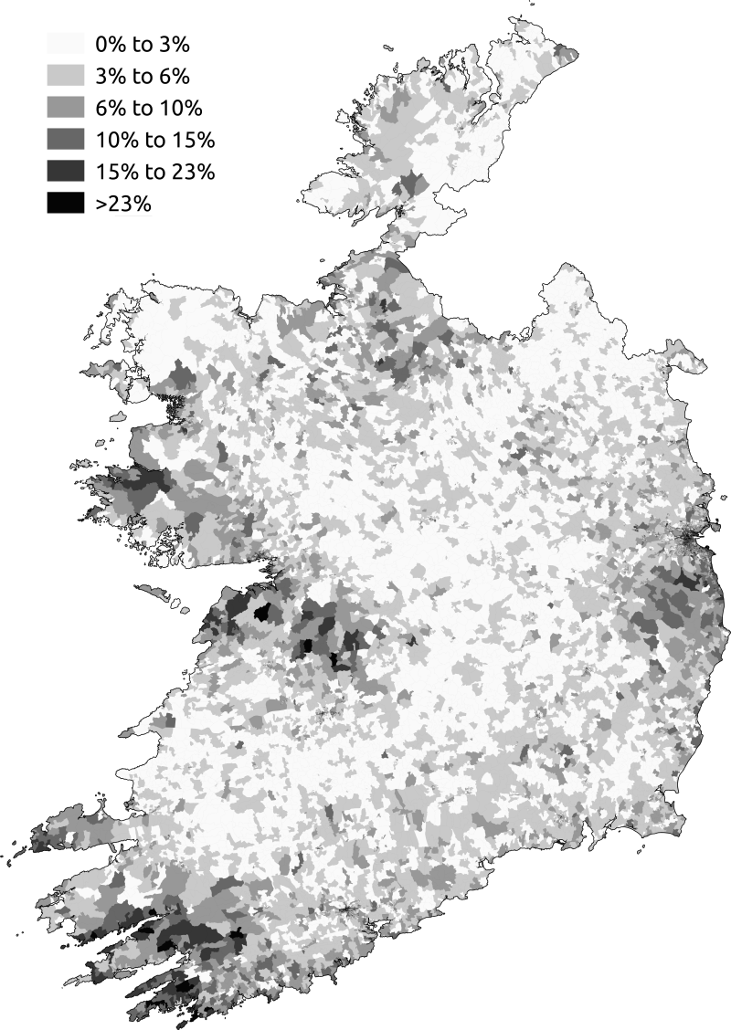
    Also, found this - percentage of respondents who said they had no religion in 2011 census.

    800px-No_religion_in_Ireland_census_2011.png

    Can kinda explain the West Cork devil-worshipping hippies and heathen West brits in the Pale, but whats going on in West/North Clare and around Clifden?


  • Registered Users Posts: 13,673 ✭✭✭✭josip


    Would a reluctance to state a religion on the census form count as "no religion"?
    Clifden would have a lot of holiday homes, but I don't think they would in any way contribute to a statistical anomaly.


  • Registered Users Posts: 715 ✭✭✭Stihl waters


    retalivity wrote: »
    Not 1920/40, but this was posted in this thread before, its a religious breakdown in Ireland from 1901 and 1911

    https://barrygriffin.com/surname-maps/index.php/sample-page/religion-maps/

    Also, found this - percentage of respondents who said they had no religion in 2011 census.

    800px-No_religion_in_Ireland_census_2011.png

    Can kinda explain the West Cork devil-worshipping hippies and heathen West brits in the Pale, but whats going on in West/North Clare and around Clifden?

    I suppose it shows what I've always thought, north clare inhabitants are a smarter higher intelligent science based breed than most of the backward bible bashing rednecks around the country :pac:


  • Advertisement
  • Registered Users Posts: 1,002 ✭✭✭Dufflecoat Fanny


    I suppose it shows what I've always thought, north clare inhabitants are a smarter higher intelligent science based breed than most of the backward bible bashing rednecks around the country :pac:

    Biddy Early country in east clare. They were always a bit wild in those parts.


  • Registered Users Posts: 3,872 ✭✭✭Dickie10


    i have heard north clare has a lot woodland is it natural or coillte planted? i have heard its very desolate and strange place is this myth from imelda riney murder/brendan odonnell or was this case before this? have read somewhere it had that reputation before the murders. it has a really low population in think for some reason, i think its because its actually a good bit of miles from any big town


  • Registered Users Posts: 14,066 ✭✭✭✭retalivity


    I suppose its also Father Ted country, that funeral Dougal did must have turned loads off.


  • Moderators, Sports Moderators Posts: 7,160 Mod ✭✭✭✭cdeb


    That was in Athlone wasn't it?

    (Someone must have done a map of the Father Ted locations!)


  • Registered Users Posts: 715 ✭✭✭Stihl waters


    Dickie10 wrote: »
    i have heard north clare has a lot woodland is it natural or coillte planted? i have heard its very desolate and strange place is this myth from imelda riney murder/brendan odonnell or was this case before this? have read somewhere it had that reputation before the murders. it has a really low population in think for some reason, i think its because its actually a good bit of miles from any big town

    The Brendan O Donnell case is the opposite side of the county to north clare, but you're right where I am is all forestry and bog, as is scarriff/whitegate area where O Donnell was from, not sure of population density but I remember reading one time it was one of the lowest in the country iirc

    Anyone a map of population density of Ireland for my curiosity, many thanks


  • Advertisement
  • Registered Users Posts: 1,002 ✭✭✭Dufflecoat Fanny


    The Brendan O Donnell case is the opposite side of the county to north clare, but you're right where I am is all forestry and bog, as is scarriff/whitegate area where O Donnell was from, not sure of population density but I remember reading one time it was one of the lowest in the country iirc

    Anyone a map of population density of Ireland for my curiosity, many thanks

    It used to be highly populated until the famine struck.


  • Registered Users Posts: 8,939 ✭✭✭Gregor Samsa


    Dickie10 wrote: »
    i have heard north clare has a lot woodland is it natural or coillte planted? i have heard its very desolate and strange place is this myth from imelda riney murder/brendan odonnell or was this case before this? have read somewhere it had that reputation before the murders. it has a really low population in think for some reason, i think its because its actually a good bit of miles from any big town

    North Clare is rural, but it's not the dark side of the moon!
    Most of it is within 40 minute drive from Ennis. A lot if it is very close to Galway city. With places like Lahinch and the Cliffs of Moher, it has a massive influx of visitors and tourists, so it's not exactly isolated.

    It has a bit of forestry, but it's mostly famous the Burren, a massive expanse of bare limestone.

    6e8827f6bad11dd44bd8cd708ba7928d.jpg

    Also, the Brendan O'Donnell case was East Clare, not North Clare. To quote a famous North Clare atheist philosopher "It's a different film! It's a very different film! It's a different shark!"


  • Registered Users Posts: 14,066 ✭✭✭✭retalivity


    Also, rural areas would tend to have a more church-going population, so seems weird why that region is an outlier.


  • Registered Users Posts: 715 ✭✭✭Stihl waters


    It used to be highly populated until the famine struck.

    True, theres an old village ruins near me that has ongoing archeological exploration as far as I'm aware, they think the population of it would have been over a thousand inhabitants at one time which would be more than villages like ballyvaughan or lisdoonvarna are now, hard to believe it


  • Registered Users Posts: 1,566 ✭✭✭atilladehun


    .


  • Moderators, Social & Fun Moderators Posts: 12,620 Mod ✭✭✭✭JupiterKid


    IAMAMORON wrote: »
    There is plenty of green areas in Dublin - it is hardly Hong Kong or Singapore.

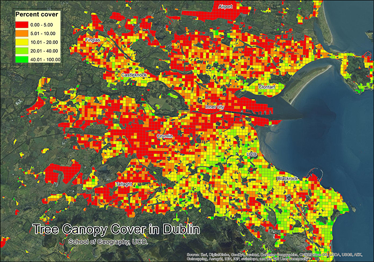
    290216-tree-urban-map-top-image.jpg


    Note how there seems to be a pretty good correlation between the areas of lower socio-economic status and diminished tree cover.


  • Registered Users Posts: 1,566 ✭✭✭atilladehun


    JupiterKid wrote: »
    Note how there seems to be a pretty good correlation between the areas of lower socio-economic status and diminished tree cover.

    Yeah it's an interesting map alright. I like it.


    A little pedantic but finglas is in the wrong spot. That's clonee and west blanchardstown.


  • Banned (with Prison Access) Posts: 9,078 ✭✭✭IAMAMORON


    JupiterKid wrote: »
    Note how there seems to be a pretty good correlation between the areas of lower socio-economic status and diminished tree cover.

    They aren't called " leafy suburbs " for nothing.

    In fairness that is as much a poor indictment of Dublin City Council as it is anything.

    The reality is that West Dublin is far newer than both the South and North side of Dublin. Hence less growth in trees and more urbanisation. The natural urban sprawl in the 40's, 50's and 60's was out to the coast and the mountains. i remember when Tallaght, Blanch and Finglas were fields littered with cows and sheep.


  • Registered Users Posts: 3,872 ✭✭✭Dickie10


    i will have to see more of clare i was only in it once 2 years ago at a match in ennis on paddys day, great day out.


  • Moderators, Politics Moderators Posts: 38,982 Mod ✭✭✭✭Seth Brundle


  • Advertisement
  • Registered Users Posts: 4,707 ✭✭✭Bobblehats


    IAMAMORON wrote: »
    remember when Tallaght, Blanch and Finglas were fields littered with cows and sheep.

    Remember when tallaght was nothing much beyond H Williams? Look at it now woooo, boomtown.


  • Registered Users Posts: 78,290 ✭✭✭✭Victor


    Bobblehats wrote: »
    Remember when tallaght was nothing much beyond H Williams? Look at it now woooo, boomtown.

    What is a shop?

    Map from 1918.

    540283.JPG


  • Moderators, Business & Finance Moderators, Motoring & Transport Moderators, Society & Culture Moderators Posts: 67,859 Mod ✭✭✭✭L1011


    retalivity wrote: »
    Can kinda explain the West Cork devil-worshipping hippies and heathen West brits in the Pale, but whats going on in West/North Clare and around Clifden?

    Distortion factor of exceptionally lightly populated areas I'd expect.

    The whole thing of a rural area going from 1 break-in to 2 break-ins having a 100% jump in break-in rates; but an urban area going from 5,000 to 6,000 only has a 20% rise and so on.


  • Registered Users Posts: 21,520 ✭✭✭✭Tell me how


    L1011 wrote: »
    Distortion factor of exceptionally lightly populated areas I'd expect.

    The whole thing of a rural area going from 1 break-in to 2 break-ins having a 100% jump in break-in rates; but an urban area going from 5,000 to 6,000 only has a 20% rise and so on.

    Think you misinterpreted or misunderstood what that map was depicting.

    The symbolism of confusing religious breakdown with break ins has not gone unnoticed mind.


  • Moderators, Recreation & Hobbies Moderators, Science, Health & Environment Moderators, Technology & Internet Moderators Posts: 90,843 Mod ✭✭✭✭Capt'n Midnight


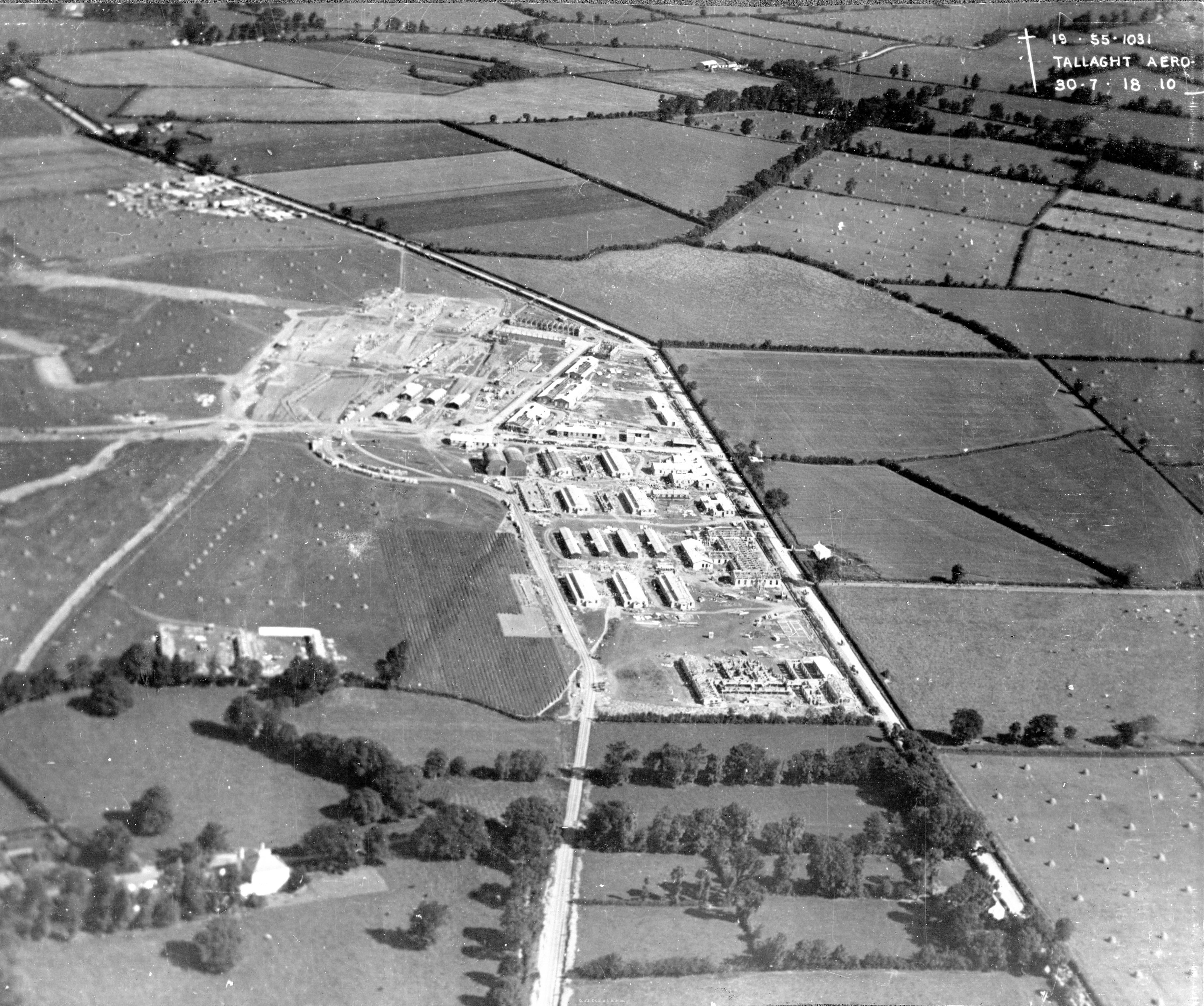
    Views of Tallaght Aerodrome 1918 - can't find the map
    AKA Cookstown / RAF Tallaght / Tallaght Aerodrome

    wm_1727-p54-01.jpg
    http://source.southdublinlibraries.ie/handle/10599/11268

    wm_TallaghtAerodromeFromHangar.jpghttp:
    http://source.southdublinlibraries.ie/handle/10599/12124


  • Moderators, Business & Finance Moderators, Motoring & Transport Moderators, Society & Culture Moderators Posts: 67,859 Mod ✭✭✭✭L1011


    Think you misinterpreted or misunderstood what that map was depicting.

    The symbolism of confusing religious breakdown with break ins has not gone unnoticed mind.

    Erm, no. Not all.

    You appear to have completely misunderstood my post and replied with something incomprehensible, though.


  • Moderators, Business & Finance Moderators, Motoring & Transport Moderators, Society & Culture Moderators Posts: 67,859 Mod ✭✭✭✭L1011


    Views of Tallaght Aerodrome 1918 - can't find the map
    AKA Cookstown / RAF Tallaght / Tallaght Aerodrome

    wm_1727-p54-01.jpg
    http://source.southdublinlibraries.ie/handle/10599/11268

    wm_TallaghtAerodromeFromHangar.jpghttp:
    http://source.southdublinlibraries.ie/handle/10599/12124

    Amazon AWS site (old Jacob/Urney factory) + much of the Airton/Broomhill industrial estates now


  • Registered Users Posts: 40,210 ✭✭✭✭ohnonotgmail


    L1011 wrote: »
    Erm, no. Not all.

    You appear to have completely misunderstood my post and replied with something incomprehensible, though.

    To be fair commenting on a map that depicts religious breakdown and mentioning break-ins could confuse the best of us. It certainly confused me.


  • Registered Users Posts: 78,290 ✭✭✭✭Victor


    Views of Tallaght Aerodrome 1918 - can't find the map
    AKA Cookstown / RAF Tallaght / Tallaght Aerodrome

    wm_1727-p54-01.jpg
    http://source.southdublinlibraries.ie/handle/10599/11268

    wm_TallaghtAerodromeFromHangar.jpghttp:
    http://source.southdublinlibraries.ie/handle/10599/12124
    Note that it was west of the (old) Belgard Road.

    The second photo shows the temporary railway that was built for the construction of the aerodrome.

    Another view http://source.southdublinlibraries.ie/handle/10599/11938 Ont he left are some of hte cottages at Colbert's Fort (street). https://www.bing.com/maps?osid=bb07152e-16bb-437e-b91a-6156310bc7c9&cp=53.295048~-6.371365&lvl=20&style=g&v=2&sV=2&form=S00027


  • Advertisement
  • Registered Users Posts: 6,475 ✭✭✭Badly Drunk Boy


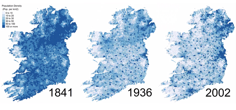
    Anyone a map of population density of Ireland for my curiosity, many thanks
    After a quick Google, I found this:

    Pop-copy.-1841-1936-2002.jpg


Advertisement