Advertisement
If you have a new account but are having problems posting or verifying your account, please email us on hello@boards.ie for help. Thanks :)
Hello all! Please ensure that you are posting a new thread or question in the appropriate forum. The Feedback forum is overwhelmed with questions that are having to be moved elsewhere. If you need help to verify your account contact hello@boards.ie

Atlantic Hurricane Season 2015

Options
123457

Comments

  • Registered Users Posts: 8,798 ✭✭✭MiskyBoyy


    Trogdor wrote: »

    Now this video's been removed. Weird :confused:


  • Closed Accounts Posts: 1,003 ✭✭✭B17G


    Update from the NHC:
    000 WTPZ65 KNHC 232328 TCUEP5

    HURRICANE PATRICIA TROPICAL CYCLONE UPDATE NWS NATIONAL HURRICANE CENTER MIAMI FL

    EP202015 625 PM CDT FRI OCT 23 2015 ...

    CATEGORY 5 HURRICANE PATRICIA MAKES LANDFALL ALONG THE COAST OF MEXICO WITH 165-MPH WINDS...

    Satellite images indicate that the center of the eye of Patricia made landfall at approximately 615 PM CDT...2315 UTC...along the coast of southwestern Mexico near Cuixmala.

    This position is also about 55 miles...85 km...west-northwest of Manzanillo, Mexico. The maximum winds were estimated to be 165 mph...270 km/h.

    SUMMARY OF 615 PM...2315 UTC...INFORMATION

    LOCATION...19.4N 105.0W ABOUT 55 MI...85 KM WNW OF MANZANILLO MEXICO MAXIMUM SUSTAINED WINDS...165 MPH...270 KM/H
    PRESENT MOVEMENT...NNE OR 15 DEGREES AT 14 MPH...22 KM/H
    MINIMUM CENTRAL PRESSURE...920 MB...27.17 INCHES

    $$ Forecaster Blake/Stewart


  • Registered Users Posts: 1,619 ✭✭✭LaVail


  • Registered Users Posts: 1 Supercatdog


    Some incredible vidoes showing up on YouTube.

    Can't post link for some reason
    http ://youtu. be/43Q0AarEBIA


  • Registered Users Posts: 8,798 ✭✭✭MiskyBoyy


    Some incredible vidoes showing up on YouTube.

    Can't post link for some reason
    http ://youtu. be/43Q0AarEBIA

    It's because you're a new user, you need to have 50 posts before you can post URL's or embed videos.

    That video's been removed by user already btw :/


  • Advertisement
  • Closed Accounts Posts: 3,766 ✭✭✭Bongalongherb


  • Banned (with Prison Access) Posts: 3,288 ✭✭✭mickmackey1


    Message from Webcams de Mexico: 'We are experiencing difficulties due to increased traffic on the site...'


  • Registered Users Posts: 883 ✭✭✭Keplar240B


    880 mBars 3rd lowest EVER recorded,


  • Registered Users Posts: 33,730 ✭✭✭✭RobertKK


    https://twitter.com/weatherchannel/status/657725822430789632

    A station near Cuixmala, Mexico (landfall point) reported 185 mph winds, gusts to 211 mph before losing data. (Estación de Biología Chamela)


  • Closed Accounts Posts: 922 ✭✭✭FWVT


    RobertKK wrote: »
    https://twitter.com/weatherchannel/status/657725822430789632

    A station near Cuixmala, Mexico (landfall point) reported 185 mph winds, gusts to 211 mph before losing data. (Estación de Biología Chamela)

    It is...or was!... an elevated station at 295 ft, according to the NHC, so not quite representative of the normal 33 ft.
    An unconfirmed sustained wind report of 185 mph and a gust to 211 mph was received from a NOAA/NWS Hydrometeorological Automated Data System (HADS) elevated station (295 ft) at Chamela-Cuixmala, Mexico near the time of landfall. This observation should be considered unofficial until it has been quality controlled.


  • Advertisement
  • Registered Users Posts: 14,360 ✭✭✭✭M.T. Cranium


    I was following this closely all day, probably the general assessment would be a very powerful storm offshore that just began to fragment a bit near landfall, no doubt there have been some localized streaks of wind damage but the worst of the surge likely hit along a nearly unpopulated 20-30 miles of coastline, fortunately. As expected, nothing very dramatic happened at Puerto Vallarta, the major tourist destination west of the landfall zone. I may have some specific details to report, there's a thread on another forum in contact with a storm chaser in the landfall area. A couple of rather run-down fishing villages and minor resorts were in the path of the eye. You can see the site where the reported 180 mph winds on land occurred by checking google earth, go to 19deg 30min N and 105deg 03min W, nearby is a biological research station near Cayeres, elevation about 90 metres, and this is the location in question. We have no reports yet from Punta Perula to Cayeres where any significant damage is likely to be. Inland flooding and mudslides may prove to be the biggest problem in the hilly region north of landfall.

    Guadalajara, Mexico's second largest city, will be treated to a rare wind and rain storm today, peak gusts likely to be around 100 km/hr there.


  • Moderators, Science, Health & Environment Moderators Posts: 11,848 Mod ✭✭✭✭Meteorite58


    Seems they have dodged a bullet as regards major structural damage so far from the initiall landfall, now attention being put on the potential from flooding and landslides especially from volcanic ash.

    NHC


    Hurricane PATRICIA Public Advisory

    Home Public Adv Fcst Adv Discussion Wind Probs Graphics Archive

    000
    WTPZ35 KNHC 240832
    TCPEP5

    BULLETIN
    HURRICANE PATRICIA ADVISORY NUMBER 18
    NWS NATIONAL HURRICANE CENTER MIAMI FL EP202015
    400 AM CDT SAT OCT 24 2015

    ...PATRICIA RAPIDLY WEAKENING OVER MEXICO...
    ...HEAVY RAINS CONTINUE...


    SUMMARY OF 400 AM CDT...0900 UTC...INFORMATION

    LOCATION...22.3N 103.1W
    ABOUT 50 MI...80 KM...SSW OF ZACATECAS MEXICO
    ABOUT 130 MI...205 KM ENE OF TEPIC MEXICO
    MAXIMUM SUSTAINED WINDS...75 MPH...120 KM/H
    PRESENT MOVEMENT...NNE OR 25 DEGREES AT 21 MPH...33 KM/H
    MINIMUM CENTRAL PRESSURE...986 MB...29.12 INCHES


    WATCHES AND WARNINGS
    CHANGES WITH THIS ADVISORY:

    The government of Mexico has discontinued the Tropical Storm
    Warning west of Manzanillo.

    SUMMARY OF WATCHES AND WARNINGS IN EFFECT:

    A Tropical Storm Warning is in effect for...
    * Manzanillo to Lazaro Cardenas

    A Tropical Storm Warning means that tropical storm conditions are
    likely occurring within the warning area.

    For storm information specific to your area, please monitor
    products issued by your national meteorological service.


    DISCUSSION AND 48-HOUR OUTLOOK
    At 400 AM CDT (0900 UTC), the center of Hurricane Patricia was
    located near latitude 22.3 North, longitude 103.1 West. Patricia is
    moving toward the north-northeast near 21 mph (33 km/h). Patricia is
    forecast to move quickly north-northeastward farther inland over
    northern and northeastern Mexico today.

    Maximum sustained winds have decreased to near 75 mph (120 km/h)
    with higher gusts. Rapid weakening is expected to continue, and
    Patricia is forecast to become a tropical storm later this morning,
    and dissipate tonight.

    Hurricane-force winds extend outward up to 25 miles (35 km) from the
    center and tropical-storm-force winds extend outward up to 290 miles
    (465 km).

    The estimated minimum central pressure is 986 mb (29.12 inches).


    HAZARDS AFFECTING LAND
    WIND: Tropical storm conditions are expected to continue across
    portions of the warning area and over inland areas, especially in
    higher elevations, near the center through this morning.

    RAINFALL: Patricia is expected to produce total rainfall
    accumulations of 8 to 12 inches, with isolated maximum amounts of
    20 inches, over the Mexican states of Nayarit, Jalisco, Colima,
    Michoacan, and Guerrero through Saturday. These rains are likely
    to produce life-threatening flash floods and mudslides. During the
    past 24 hours, a rainfall total of 10.25 inches (260 mm) has been
    reported at Nevado De Colima in Jalisco state.

    STORM SURGE: Water levels are expected to gradually subside but
    will remain above normal through late today.


    NEXT ADVISORY
    Next intermediate advisory at 700 AM CDT.
    Next complete advisory at 1000 AM CDT.

    $$
    Forecaster Cangialosi/Stewart


  • Closed Accounts Posts: 922 ✭✭✭FWVT


    It's remarkable how little shear and warm waters Patricia had to play with, yet the forecasts woefully underplayed its potential. It is a textbook hurricane, yet the models still couldn't handle it.

    Here's a full detailed analysis https://irishweatheronline.wordpress.com/2015/10/24/an-analysis-of-record-hurricane-patricia/


  • Closed Accounts Posts: 922 ✭✭✭FWVT


    Tropical Cyclone Chapala in the Arabian Sea will hit Yemen as a Cat 3/4 on Saturday. It's become a hurricane in less than 24 hours, way faster than Patricia.

    https://irishweatheronline.wordpress.com/2015/10/29/tropical-cyclone-chapala-intensifying-and-heading-for-arabian-peninsula/


  • Registered Users Posts: 20,342 ✭✭✭✭Rikand


    FWVT wrote: »
    Tropical Cyclone Chapala in the Arabian Sea will hit Yemen as a Cat 3/4 on Saturday. It's become a hurricane in less than 24 hours, way faster than Patricia.

    https://irishweatheronline.wordpress.com/2015/10/29/tropical-cyclone-chapala-intensifying-and-heading-for-arabian-peninsula/

    Very cool image of it forming from iwo with the eye and defined rain bands

    chapala-gif.gif?w=611&h=460


  • Closed Accounts Posts: 1,003 ✭✭✭B17G


    JTWC advisory has it weakening to 80 kts before landfall.

    http://www.usno.navy.mil/NOOC/nmfc-ph/RSS/jtwc/warnings/io0415.gif


  • Closed Accounts Posts: 922 ✭✭✭FWVT


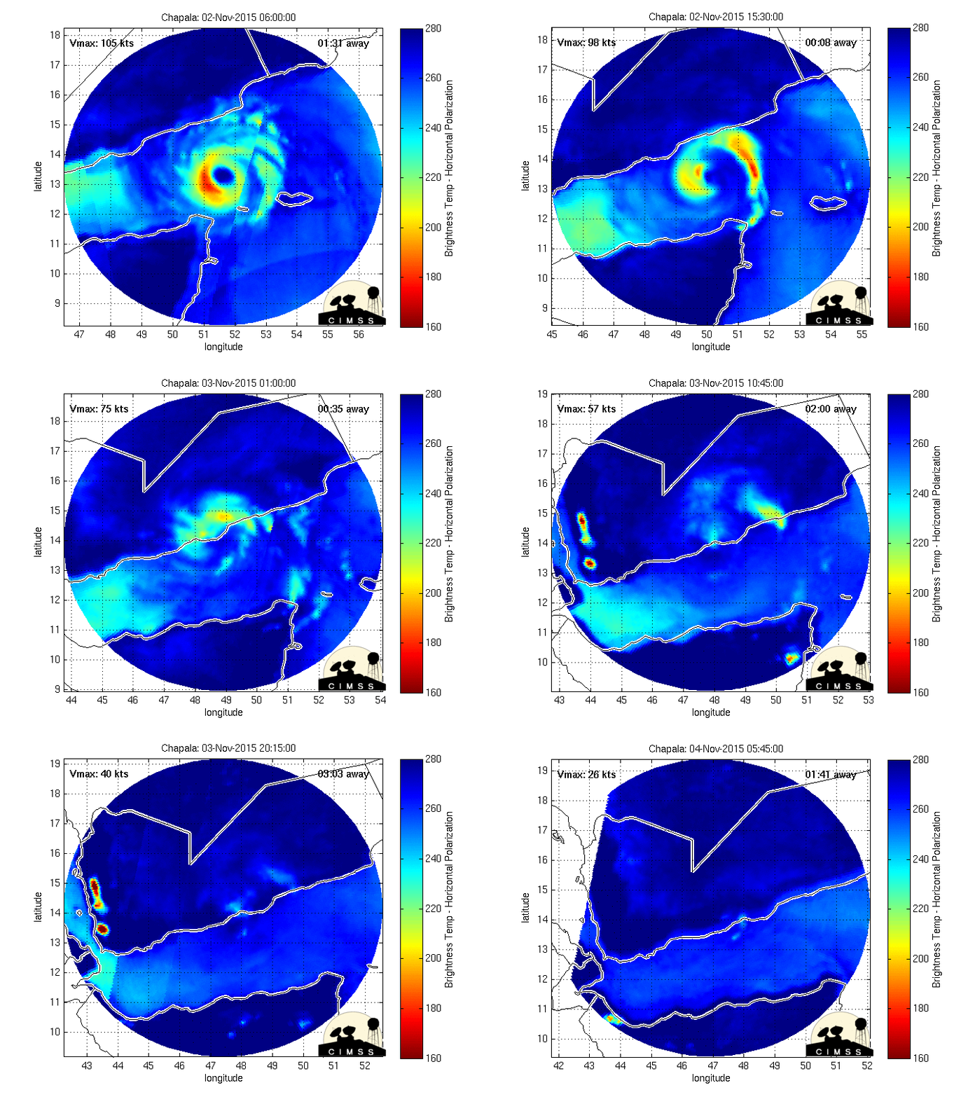
    Tropical Cyclone Chapala has killed 1 and injured 9 in Socotra today and is still a Cat 2/3 as it heads towards the Yemen coast.


  • Closed Accounts Posts: 1,003 ✭✭✭B17G


    Has a good looking structure with a distinctive eye. Currently 110 kts. Due to weaken to 75 kts at landfall.

    367356.jpg


  • Registered Users Posts: 1,315 ✭✭✭snowstreams


    I wonder what affect that will have on desert lands when they suddenly get ten years worth of rainfall in a few days?


  • Closed Accounts Posts: 922 ✭✭✭FWVT


    Pretty devastating if you're in the path of it. I've been in a wadi and the force of erosion of the rocks is something else. Yemen is a country with no natural streams or rivers, just wadis.

    Amazing how this storm has threaded the eye of a needle to make it right up the centre of the Gulf of Aden. I mean what are the chances?

    last48hrs.gif


  • Advertisement
  • Closed Accounts Posts: 922 ✭✭✭FWVT


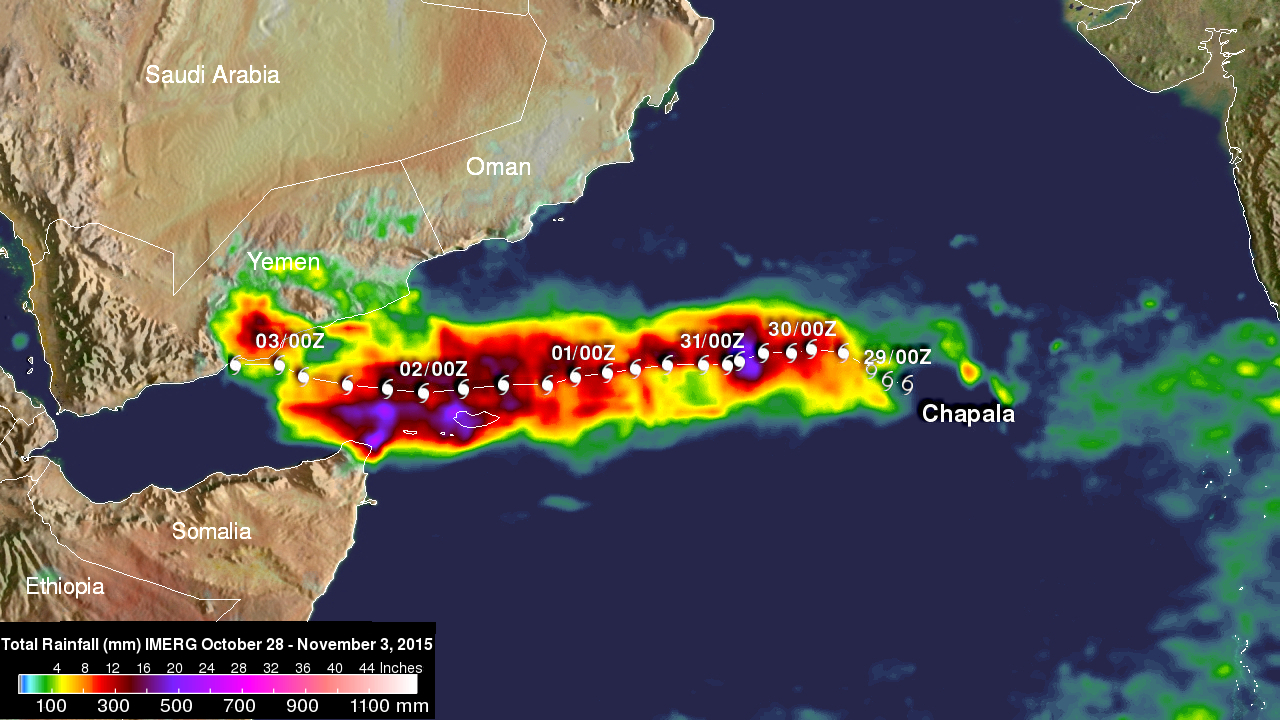
    Great GPM IMERG image of rainfall totals of Chapala, showing 500 mm over Socotra.

    chapala_rain_28_october-3_november_2015.jpg


  • Closed Accounts Posts: 1,003 ✭✭✭B17G


    Another storm in the same region. This one will pass nearer to the island of Socotra than the last one did it seems.

    http://www.usno.navy.mil/NOOC/nmfc-ph/RSS/jtwc/warnings/io0515.gif

    367873.png


  • Closed Accounts Posts: 922 ✭✭✭FWVT


    The combination of record warm ocean heat content in the Indian Ocean and a phase-3 MJO has led to interesting times in the Indian Ocean of late. It's remarkable, though, how Megh is following an identical track to Chapala. There is also another Invest area east of southern India which looks set to make it across the Indian landmass and come out the other side as another possible cyclone in the Arabian Sea next week.

    These are two charts of Tropical Cyclone Heat Potential (in kJ/cm²) from both yesterday and before Chapala last week. Note how Chapala has churned up colder waters from below, and Megh is currently along the 50 kJ/cm² threshold just west of 60E. TCHP values of over 50 jK/cm² are required for rapid intensification, which is why Megh has been only intensifying slowly and will not reach the heights of Chapala.

    Yesterday
    2015310ni.jpg

    Before Chapala
    2015301ni.jpg


  • Closed Accounts Posts: 922 ✭✭✭FWVT


    It has managed to intensify rapidly overnight and is now 110 knots as it hits Socotra directly.


  • Closed Accounts Posts: 1,003 ✭✭✭B17G


    FWVT wrote: »
    It has managed to intensify rapidly overnight and is now 110 knots as it hits Socotra directly.

    367906.jpg


  • Closed Accounts Posts: 922 ✭✭✭FWVT


    It has just crossed Socotra. Thankfully the strongest winds will have been out to sea.

    85 GHz at 1039Z

    20151108.1039.noaa19.x.89_1deg.05AMEGH.110kts-941mb-126N-549E.100pc.jpg

    Earlier rain-rates were around 1 - 1.2 inches per hour.

    20151108-0313-f18-x-rain-05amegh-90kts-956mb-127n-561e-60pc.jpg?w=500&h=500


  • Registered Users Posts: 11,134 ✭✭✭✭maquiladora


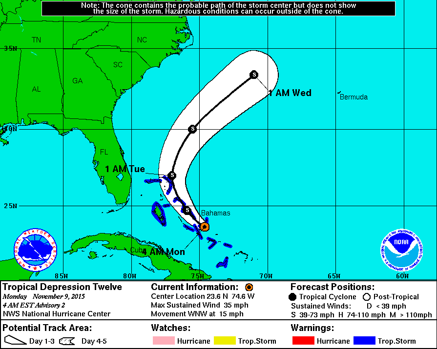
    A late season one. TD 12, soon to be upgrade to a TS.

    AL122015_5W_002_0.GIF


  • Registered Users Posts: 17,797 ✭✭✭✭hatrickpatrick


    What's going on here? We're supposed to be in an almost record breaking El Nino year and yet this season has now had an average number of named storms and a cat 4 (in the West Atlantic no less!) which is the strongest Atlantic system in four years.

    Has El Nino been weaker than expected so far, or has the Atlantic surprisingly managed to fight it off?


  • Registered Users Posts: 11,134 ✭✭✭✭maquiladora


    What's going on here? We're supposed to be in an almost record breaking El Nino year and yet this season has now had an average number of named storms and a cat 4 (in the West Atlantic no less!) which is the strongest Atlantic system in four years.

    Has El Nino been weaker than expected so far, or has the Atlantic surprisingly managed to fight it off?

    The majority of the storms have been weak though and most of them had their development limited by adverse conditions, so El Nino has definitely had a significant impact. The number of storms that reached hurricane strength is half of what would be expected in an average season.


  • Advertisement
  • Registered Users Posts: 17,797 ✭✭✭✭hatrickpatrick


    The majority of the storms have been weak though and most of them had their development limited by adverse conditions, so El Nino has definitely had a significant impact. The number of storms that reached hurricane strength is half of what would be expected in an average season.

    True, but the fact that so many have managed to develop at all - more than the previous two years which weren't El Nino years - still strikes me as surprising.

    I guess this means that dry air invasion of the Atlantic actually has a bigger impact on storm development than wind shear. That's the notable difference this year compared with previous years, apart from El Nino - the Sahara has been much quieter than in '13 or '14.


Advertisement