Advertisement
If you have a new account but are having problems posting or verifying your account, please email us on hello@boards.ie for help. Thanks :)
Hello all! Please ensure that you are posting a new thread or question in the appropriate forum. The Feedback forum is overwhelmed with questions that are having to be moved elsewhere. If you need help to verify your account contact hello@boards.ie
Hi there,
There is an issue with role permissions that is being worked on at the moment.
If you are having trouble with access or permissions on regional forums please post here to get access: https://www.boards.ie/discussion/2058365403/you-do-not-have-permission-for-that#latest

Very Warm, Thunderstorms, Flash flooding - Friday through weekend

  • 15-07-2014 4:10am
    #1
    Registered Users, Registered Users 2 Posts: 24,411 ✭✭✭✭


    On Thursday an area of instability will approach the country from the south after some very warm and humid air embeds itself over the country. Incidentally this brings nice beach and garden weather at times with temperatures in to the mid twenties but also the real threat of some potentially severe storms.

    The main focus of concern is Thursday night and Friday morning. This is the period that we could see some severe weather originating in the Bay of Biscay and driving north toward Ireland with focus of attention the south coast but even more so the southeast and east though in reality all areas are at risk.

    This will probably materialise and at this point flash flooding is likely so it's something to be aware of. Frequent lightning and some hail is also possible but the hail is more likely during the weekend in western and midland areas. Rainfall totals could mount quickly in downpours.

    Having seen the main action through on Thursday night and Friday the focus turns inland for the weekend were thunderstorms should develop when convection gets going during daylight. Though different in origin and homegrown so to speak these could conceivably be unusually large and intense storms for Ireland. All the ingredients are there for intense weather. The midlands, west and north are most at risk over the weekend.

    It will be very warm and humid throughout the weekend.

    Thunderstorms by their nature are hit and miss. Just make sure you don't caught out! I'm sure the mods will change it as best fits the risk because the models can change suddenly. I'm happy enough with this forecast.


«13456717

Comments

  • Closed Accounts Posts: 1,745 ✭✭✭whitebriar


    In theory,if I liked lightning and for that initial biscay push wexfords the place to be.
    The fly in the ointment from the thunderstorm point of view is a gale off the Irish Sea.
    That could scupper and often does scupper the thunder.
    A lot of rain though.


  • Closed Accounts Posts: 3,548 ✭✭✭Harps


    BBC forecast this morning warned of 'potent and disruptive thunderstorms' for Friday and Saturday with some very bright colours across Ireland and the UK on the rainfall chart. Temperatures will get above 30C over here with high humidity so it's definitely going to be an interesting spell of weather if all goes to plan

    Needless to say though the forecast will change over the next 48 hours so it's still too early to get our hopes up


  • Registered Users, Registered Users 2 Posts: 474 ✭✭KingdomRushed


    England looks set for the really severe weather, more particularly the south and east of England. There will probably be a few thunderstorms here, but I don't think it will be explosive enough for anything truly memorable.


  • Moderators, Science, Health & Environment Moderators Posts: 17,068 Mod ✭✭✭✭Gonzo


    temperatures here also will be alot lower than England, particularly eastern Ireland may only see 17-20C over next few days, with higher temperatures of 18-23C in the midlands and west. That's still warm enough for most people.


  • Registered Users, Registered Users 2 Posts: 5,068 ✭✭✭Iancar29


    Not be best to keep everything in the Convective thread no? :/


  • Advertisement
  • Registered Users, Registered Users 2 Posts: 24,411 ✭✭✭✭Kermit.de.frog


    At the moment this looks like a potential "event" (that could change) rather than the usual inland convective storms with warnings possible nearer the time from the met agencies so I think it deserves a separate build up and discussion thread. And lets be honest - it's been a pretty straight forward summer so far - so lets hope this sparks some interest.

    I see mentioned above the possibility of some high rainfall totals, rates too but I disagree a little about the winds off the Irish sea. I don't think it will be that brisk and in any case on Thursday night it's not the usual inland convective based storms but something more organised from the south that we have to watch. These sort of setups tend to deliver. I have memories of good storms from identical synoptic situations in previous summers.

    Will post a more comprehensive update after the 12pm model runs.


  • Registered Users, Registered Users 2 Posts: 24,717 ✭✭✭✭Larbre34


    Iancar29 wrote: »
    Not be best to keep everything in the Convective thread no? :/

    More for modelling, this is no harm for a "golfball hail in my back garden" or "why is it only drizzling" thread, specific to this progged event


  • Registered Users, Registered Users 2 Posts: 4,939 ✭✭✭goat2


    mt cranium made a long term forecast and so far his predictions are right,


  • Registered Users, Registered Users 2 Posts: 24,411 ✭✭✭✭Kermit.de.frog


    whitebriar wrote: »
    In theory,if I liked lightning and for that initial biscay push wexfords the place to be.

    Some of the higher resolution models certainly giving signals that way and some decent rain rates too.


    314648.png

    12 pm GFS delays by 6 hours the advance of the shower troughs on Thursday night and continues it's random precipitation generator. A bit of intuition is needed. We know broadly what the situation will be with pulses of rain and embedded thunderstorms moving north but we'll have to wait another 24 hrs to get a more accurate picture. Be interesting to see the ECM charts later on.


  • Closed Accounts Posts: 1,745 ✭✭✭whitebriar


    Some of the higher resolution models certainly giving signals that way and some decent rain rates too.


    12 pm GFS delays by 6 hours the advance of the shower troughs on Thursday night and continues it's random precipitation generator. A bit of intuition is needed. We know broadly what the situation will be with pulses of rain and embedded thunderstorms moving north but we'll have to wait another 24 hrs to get a more accurate picture. Be interesting to see the ECM charts later on.
    yup
    Isn't it funny how nature repeats itself.
    Some of the most fantastic biscay events in my lifetime followed that same pattern with massive storms with mad lightning importing themselves into Wexford.They usually eventually impact the Arklow area but whilst still potent and bloody good near Dublin they lose some ooumph heading north.
    Hence they are worth a chase the hour or so down the M11 if they are Biscay/welsh stuff and position yourself on higher ground near the sea (plenty east of Enniscorthy or just north of courtown harbour)
    The night Michael Jackson died (google the date,lightning strike records,charts etc) was a classic example of wexfords fortune though I think it was a welsh import that night.
    We were teased listening to the long rumbles and all the forks for a good hour non stop in Arklow that night from the storm which at that point was south of Gorey.
    2hrs into that and it came overhead.Thunder shaking the house like mortar bombs and continuous non stop forks.
    There are in my opinion no storms quite as potent and long lasting as a biscay or welsh import source.

    Regarding what I said earlier on the Irish Sea,I just don't want to see a returning lower RH feed entering the mix.

    On a related note,serious drought in the Wexford/South Wicklow area (we got none of the recent rain ye got in Dublin) so we could do with these downpours!!


  • Advertisement
  • Registered Users, Registered Users 2 Posts: 6,238 ✭✭✭Oneiric 3


    whitebriar wrote: »
    yup

    The night Michael Jackson died (google the date,lightning strike records,charts etc) was a classic example of wexfords fortune though I think it was a welsh import that night.
    We were teased listening to the long rumbles and all the forks for a good hour non stop in Arklow that night from the storm which at that point was south of Gorey.
    2hrs into that and it came overhead.Thunder shaking the house like mortar bombs and continuous non stop forks.
    There are in my opinion no storms quite as potent and long lasting as a biscay or welsh import source.

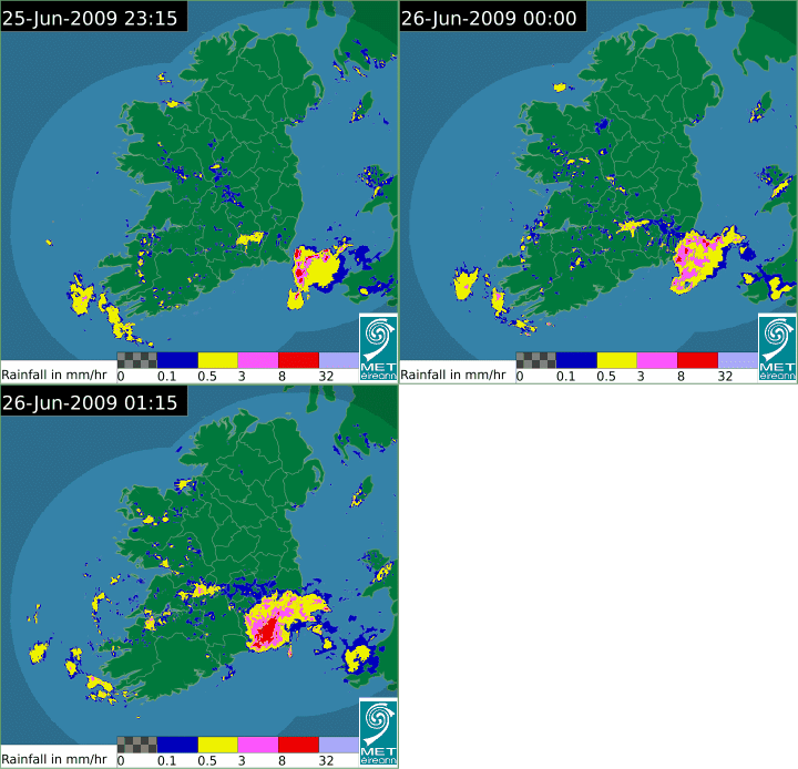
    I was in full storm mode that night so got a chance to cache a couple of radar images as the storm/s moved in. I do recall a lot of sferics being picked up that night along southeast coastal regions.

    4ZaJrc.gif
    C/O Met.ie

    Chart for 00z that night, thundery trough lines slicing up towards SE coast:

    314701.png
    C/O UK Met

    We got the remains of those showers (minus the thunder) the next morning; they were monsoonal. Both sky and atmosphere a thick, soupy dark grey as the rain poured, yet everyone was out in their teeshirts. Classic Summer weather. If it rained like that 365/24/7, I'd not mind in the least.

    New Moon


  • Closed Accounts Posts: 1,745 ✭✭✭whitebriar


    Cheers big ears.I'd forgotten the full specifics and how big that storm system/shower was-basically covering all of co wexford as it hit shore.
    I think it may have been born around the bristol channel south wales area?


  • Registered Users, Registered Users 2 Posts: 3,750 ✭✭✭fleet_admiral


    Im going to take a spin down to the Hook on thursday night to (hopefully) see the storm


  • Registered Users, Registered Users 2 Posts: 6,194 ✭✭✭Elmer Blooker


    The talk here of Wexford thunderstorms reminds me of a big one on this night which was the beginning of the big August heat wave in 2003. I was on me holliers down there and it was absolutely glorious, who needs the Mediterranean when we can get weather like that!
    bracka20030805.gif


  • Registered Users, Registered Users 2 Posts: 1,785 ✭✭✭piuswal


    Have a look at www.yr.no for places like Rosslare Harbour (you can in fact enter most places and they'll produce values) for forecasted hourly rainfall values for later Thursday into Friday.


  • Registered Users, Registered Users 2 Posts: 24,411 ✭✭✭✭Kermit.de.frog


    Tomorrow night is coming in to the 48 hr range. Euro4 has the focus of the action in the southwest but this will certainly change over the next few outputs.

    14071800_1600.gif

    GFS shows less intense but more widespread pulses of rain with the southeast the main focus.

    ukprec.png

    Very warm tomorrow btw - temperatures in to the mid 20's inland.

    The south and midlands of the UK could be in for a hammering during Friday night. They will be getting nice imports from France.


  • Registered Users, Registered Users 2 Posts: 7,248 ✭✭✭pad199207


    I predict Heavy Rain pushing up from the South with a few scattered sferics along the Waterford Coastline.


  • Registered Users, Registered Users 2 Posts: 24,411 ✭✭✭✭Kermit.de.frog


    pad199207 wrote: »
    I predict Heavy Rain pushing up from the South with a few scattered sferics along the Waterford Coastline.

    Let's not get ahead of ourselves with the old optimism.;)


  • Closed Accounts Posts: 1,745 ✭✭✭whitebriar


    pad199207 wrote: »
    I predict Heavy Rain pushing up from the South with a few scattered sferics along the Waterford Coastline.
    Yeah that is a probability given the perfect storm making conditions are way east of us to the south so you might be looking for imports that just dont make it.


  • Registered Users, Registered Users 2 Posts: 24,717 ✭✭✭✭Larbre34


    Meanwhile, in the alternative reality that is the Irish Indo -

    "While the projected rainfall – about 10mm – is usually not enough to fall within warning criteria, the short bursts of rain are a cause of concern for forecasters.

    These heavy downpours may be as intense as those seen in Dublin in October 2011 when a number of rivers burst their banks, resulting in widespread infrastructural damage in the city."


    Take your pick from lazy, careless, scaremongering.


  • Advertisement
  • Registered Users, Registered Users 2 Posts: 1,628 ✭✭✭Billcarson


    Hope i get some thunderstorms over the coming days,but overall im not really looking forward to the coming weather,warm,humid,sticky,sweaty stuff. Cant stand humidity especially at night when you are trying to get to sleep.


  • Registered Users, Registered Users 2 Posts: 1,478 ✭✭✭vickers209


    Feeling very warm in wicklow at the minute, 25c according to the car while driving


  • Closed Accounts Posts: 1,745 ✭✭✭whitebriar


    Got a peak of 24.4c today and currently 22.1c here in costa del Arklow.
    Utterly Balmy.
    Lots of penting up energy and we haven't even got high 850s yet.


  • Registered Users, Registered Users 2 Posts: 18,061 ✭✭✭✭Thargor


    Do you think this Sunday will be a hot one in Galway? I mean heatwave temps not just pleasant...


  • Registered Users, Registered Users 2 Posts: 24,411 ✭✭✭✭Kermit.de.frog


    GFS a bit of an upgrade for tomorrow night. We are on track and things are bubbling nicely.

    Thargor - perhaps not heatwave temps on Sunday but still very warm, low- mid 20's. However next week could be a hot one but we will have to wait a little longer to see how that develops.


  • Registered Users, Registered Users 2 Posts: 7,816 ✭✭✭Calibos


    Hopefully MT's forecast for Sunday is accurate. ie. Reasonably Sunny, Reasonably calm, Reasonably Warm. Bray Airshow is on that day as well as Man U playing Bray Wanderers.


  • Registered Users, Registered Users 2 Posts: 33,761 ✭✭✭✭RobertKK


    The UK met office do seem confident we will get thunderstorms here tomorrow evening/night.


  • Registered Users, Registered Users 2 Posts: 2,412 ✭✭✭lolie


    Bbc weather giving heavy possibly thundery showers moving up late tomorrow night.
    Any on Saturday in England it's forecasting intense possibly violent thunderstorms and disruption on Saturday.


  • Registered Users, Registered Users 2 Posts: 24,717 ✭✭✭✭Larbre34


    The Open golf in Merseyside could be rightly messed up.


  • Advertisement
  • Registered Users, Registered Users 2 Posts: 14,741 ✭✭✭✭M.T. Cranium


    Watching this closely, still think that the zone most at risk of heavy or severe storms would be something like Wexford-Carlow northwest through Laois, Offaly, west Kildare into east Galway, possibly in tandem with a second impulse moving north through Cork, Clare and western Galway, and later these might then reduce below heavy or severe limits moving further north, but Donegal Bay region still in the mix by Friday afternoon. That scenario would be from Thursday late evening to Friday mid-day or afternoon. Having said that, I think it will have the potential to create one or two areas of torrential rainfall resulting in localized flood concerns, so would advise keeping close to the forum (and of course your news media) and/or the radar if you're experienced and know how to use it. Expect cells of concern to your local area to come at you from the SSE.

    Saturday's activity is somewhat more of an afterthought but could be significant in parts of north Leinster and east Ulster. That activity would be drifting more from west to east again. Britain appears likely to get a pounding from a frontal zone that develops there Friday night into Saturday, extending from about Newcastle south to London. To the west of this, some long-duration thunderstorm cells could give local rainfalls of 100-150 mm in parts of the east Midlands and regions near London. Back further west for the Open it's more likely to be 25-30 mm. Delays are only likely from lightning dangers as the sandy soil should be able to cope with that fairly easily.

    Sunday (back to Ireland) at the present time looks a bit more widely scattered so that most but not all places should have a reasonably fair weather day. This could change closer to the time, however.

    I won't be all over this thread given that I am almost on holiday except for an hour or two a day of weather watching, so any further thoughts from me would be over in the forecast thread from time to time.


  • Moderators, Science, Health & Environment Moderators Posts: 17,068 Mod ✭✭✭✭Gonzo


    next monday and tuesday look like we could see 25/26C in parts of Ireland, cooler after that but still warm around 21/22C. The next 10 days look great for those who like 21C+ by day and 15C+ by night!

    Today was nice at 21/22C but from here on in most days will be warmer and more muggy than today.


  • Registered Users, Registered Users 2 Posts: 12,780 ✭✭✭✭ninebeanrows


    UK Meso has that band really pepping up as it moves northwards across Ireland Friday morning..

    At first heavy pulses into the southwest but it is expected to quickly extend east with some white returns in the predicted precipitation radar as it approaches Dublin near 5am.


  • Registered Users, Registered Users 2 Posts: 17,797 ✭✭✭✭hatrickpatrick


    Heading to a boat party for the weekend in Killaloe (Clare), this likely to have an impact?


  • Registered Users, Registered Users 2 Posts: 7,296 ✭✭✭pauldry


    North and west are looking at 25mm

    southeast and south 50mm

    so here goes

    Thurs Fri sat guesses

    oak park 48mm
    cork 45mm
    Casement 30mm
    Johnstone 35mm
    mullingar 28mm
    claremorris 25mm
    finner 22mm


  • Registered Users, Registered Users 2 Posts: 3,165 ✭✭✭JanuarySnowstor


    Bay of biscay thundery low where have you been ????
    Such a classic 80s summer event has been lacking over the last decade.

    Tomorrow nights low looks up there with the best with widespread thunder and lightning a possibility. Could be hit and miss aswell though such is the nature of the beast.

    Tomorrow afternoon will tell a lot as we see storms develop to our south


  • Advertisement
  • Registered Users, Registered Users 2 Posts: 6,333 ✭✭✭sunbabe08


    i'll believe it when i see it and hear it.


  • Registered Users, Registered Users 2 Posts: 7,296 ✭✭✭pauldry


    Slightly worried looking at satellite that atlantic is trying to take some of the heat potential away from these storms.

    However hopefully the drizzle and rain in the Northwest gets pushed away and Biscay Irelands yours.


  • Registered Users, Registered Users 2 Posts: 24,411 ✭✭✭✭Kermit.de.frog


    Real heatwave risk next week. But for tomorrow's potential - we are on track. :) Thunderstorms moving north at a brisk pace could deliver severe downpours locally and some decent lightning. Not everywhere will see lightning or heavy rain. These pulses can be very localised. Some will see just rain, others just lightning, some will get both and some will get nothing at all. It's just the nature of this setup.


  • Registered Users, Registered Users 2 Posts: 7,248 ✭✭✭pad199207


    Downgrade for the east and SE tonight according to the BBC Graphics


  • Closed Accounts Posts: 4,434 ✭✭✭northgirl


    pad199207 wrote: »
    Downgrade for the east and SE tonight according to the BBC Graphics

    :(


  • Advertisement
  • Registered Users, Registered Users 2 Posts: 1,478 ✭✭✭vickers209


    Met.ie issued warning
    National Weather Warnings

    STATUS YELLOW

    Weather Advisory for Ireland

    Warm and very humid weather with possible heavy showers, thunderstorms with hail which may lead to local flooding, disruption or possible damage tonight, Friday and Saturday.
    Issued:
    Thursday 17 July 2014 07:00
    Valid:
    Thursday 17 July 2014 21:00 to Saturday 19 July 2014 21:00


  • Registered Users, Registered Users 2 Posts: 24,717 ✭✭✭✭Larbre34


    pad199207 wrote: »
    Downgrade for the east and SE tonight according to the BBC Graphics

    I wouldn't pay much attention to that, stick to the MetÉ forecasts and local updates.


  • Closed Accounts Posts: 3,548 ✭✭✭Harps


    The hot humid air has really arrived here in London now, had a 'low' of 19C last night and were expecting up to 32C by the weekend! The severe storms forecast has been pushed a bit west this morning but still looks good for much of England

    Tonight/tomorrow looks like a narrow and fast moving band of rain so I doubt flooding will be an issue, still potential for some severe weather though if it manages to hold it's strength as it moves up through the country. Wexford & Waterford look like the place to be to start with but it'll be a nowcast as to what happens next, Dublin and the east coast still in the firing line as well.


  • Registered Users, Registered Users 2 Posts: 14,357 ✭✭✭✭leahyl


    From met.ie:

    Tonight

    The heavy, thundery rain will extend northwards Thursday night to affect most if not all parts of the country with locally heavy falls and poor visibility.
    A warm and humid night with temperatures not falling below 13 to 17 degrees in fresh easterly winds.


    Tomorrow

    Friday: Warm and humid with hazy sunny spells and heavy, thundery showers with a risk of hail and lightning. Temperatures of 18 to 22 degrees.
    A windy morning with fresh and gusty easterly winds but easing down during the day and veering southerly.

    Outlook

    Warm and muggy Friday night with some heavy showers in places and a further risk of isolated thunderstorms. Temperatures not falling below 14 to 17 degrees and there will be fog patches also as the winds ease down.

    Saturday: A very warm, muggy day with fog patches. Highest temperatures 18to 24 degrees in almost calm conditions.
    Hazy sunshine will occur but there will be heavy downpours with hail and lightning and a risk of damage and disruption.


    :eek::eek:


  • Registered Users, Registered Users 2 Posts: 24,717 ✭✭✭✭Larbre34


    Really nailing their colours to the mast with that. The charts if anything do look more likely to impact Irish Sea regions of Britain and the south of Ireland


  • Registered Users, Registered Users 2 Posts: 1,523 ✭✭✭Reckless Abandonment


    Larbre34 wrote: »
    Really nailing their colours to the mast with that. The charts if anything do look more likely to impact Irish Sea regions of Britain and the south of Ireland
    Probably a fair warning. Could be a regular wet night/day or you get one of the downpours that wrecks a very local area.


  • Registered Users, Registered Users 2 Posts: 52 ✭✭irishharper


    Hi guys,
    Family wedding Saturday in Tipperary, forecast sounds very bad??
    Will be keeping a close eye on this thread


  • Registered Users, Registered Users 2 Posts: 24,717 ✭✭✭✭Larbre34


    Hi guys,
    Family wedding Saturday in Tipperary, forecast sounds very bad??
    Will be keeping a close eye on this thread

    All you need to monitor are the radar animations on MetÉ or raintoday.co.uk and they will show best what is bubbling up in your vicinity. Although there will be torrential showers around, your wedding party would be very unlucky not to get decent dry spells for transport and photos etc. Fingers crossed they might even escape the showers completely if local conditions are favourable.


  • Registered Users, Registered Users 2 Posts: 12,780 ✭✭✭✭ninebeanrows


    Saturday's big convective system over the UK still has a chance of impacting eastern parts of Ireland so we must also keep an eye on that potentially disruptive feature considering Longitude etc..


  • Registered Users, Registered Users 2 Posts: 9,732 ✭✭✭weisses


    Looks like the West is getting the rain and the east all the lightning then ??

    fukcin typical :(


  • Advertisement
This discussion has been closed.
Advertisement