Advertisement
If you have a new account but are having problems posting or verifying your account, please email us on hello@boards.ie for help. Thanks :)
Hello all! Please ensure that you are posting a new thread or question in the appropriate forum. The Feedback forum is overwhelmed with questions that are having to be moved elsewhere. If you need help to verify your account contact hello@boards.ie

The great big "ask an airline pilot" thread!

Options
13132343637116

Comments

  • Moderators, Category Moderators, Arts Moderators, Entertainment Moderators, Social & Fun Moderators Posts: 16,587 CMod ✭✭✭✭faceman


    2 Questions about the A330-300 and turbulence. I'm flying transatlantic in a few days and upto all my long haul travel has been either on a 777 or the rare use of an A380

    As I'm flying over the Atlantic in December I'd imagine it could be bumpier than a summer trip so I was wondering about the A330 and turbulence. I've heard that the 330 isn't the most comfortable flight in turbulence compared to the 777. Then again turbulence isn't comfortable full stop!

    So question 1 is the turbulence matter an urban myth?

    Question 2, from a pilot's perspective is the B777 or A330 the more preferable choice and why? (Purely from a pilot's perspective)


  • Registered Users Posts: 10,059 ✭✭✭✭smurfjed


    We started operating the B777-200 in 1997 and the A330-300 last year, the general consensus is that the A330 isn't as smooth in turbulence.

    I have friends who have flown both, both are excellent aircraft, but at least for us, the B777 is the preferred fleet due to the size of the fleet, the route structure and the earning potential (more flying = higher productivity payments).

    smurfjed


  • Closed Accounts Posts: 1,326 ✭✭✭Bearcat


    Turbulence is no fable but reality...google inter tropical convergence zones. Winter months can see strong jet streams and associated turb on the polar side of these jets.

    Managing routes through these areas is critical.

    A330 I don't have issues with in Turb.

    If your in moderate Turb be it in a 330/777 your still going to get chucked about.


  • Registered Users Posts: 1,729 ✭✭✭martinsvi


    correct me if I'm wrong but inter tropical convergence zones has very little to do with a trip from Europe to North America (I assume that that's the route in question) as these zones are close to equator

    as far as I know - colder air means less energy for storms etc. but at the same time in winter jet stream lies at lower altitudes and latitudes meaning that "hitting the edge" of the stream is more likely where strong wind shears can cause a very rough ride..

    from meteorology point of view my understanding is that winter flights should encounter less turbulence... question to pilots and frequent transatlantic travelers - which season has more turbulence from your experience?


  • Closed Accounts Posts: 1,326 ✭✭✭Bearcat


    Sorry Martin....knackered today, so post re ITCZ's maybe a bit off....polar air in the winter months moves south clashing with the warmer air from the south which increases the intensity of jet streams in the winter months and associated turbulence .

    http://www.ehow.com/about_5103731_jet-stream-information.html

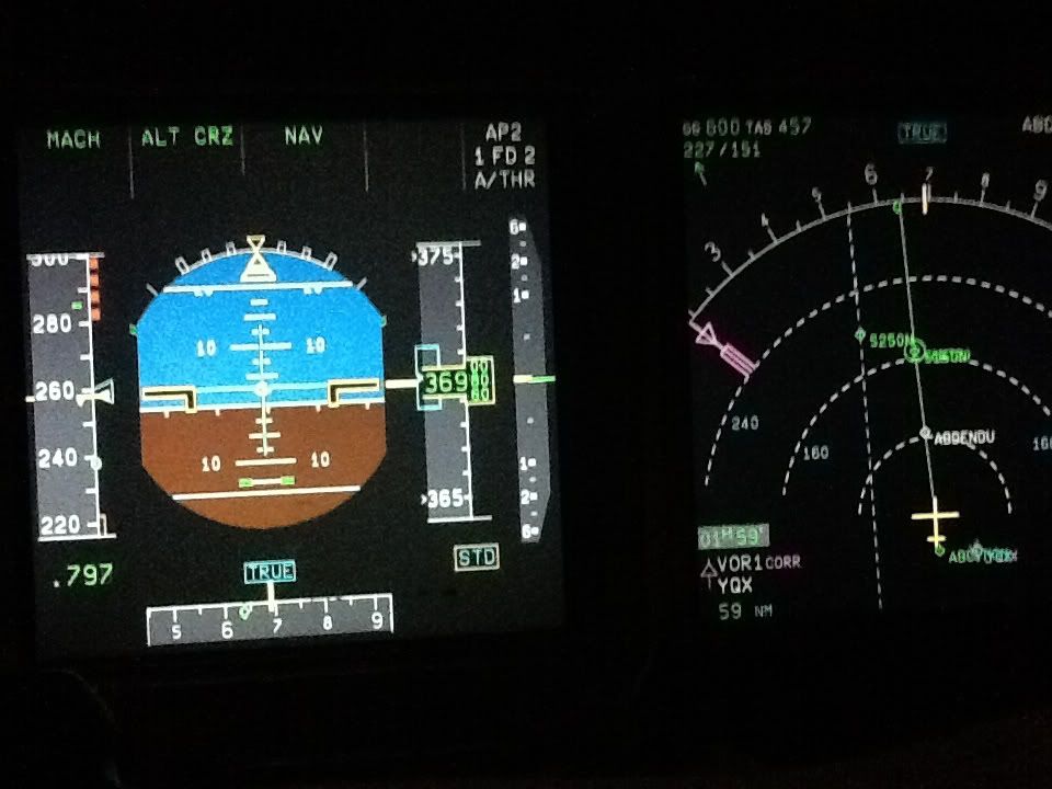
    Here's us sitting in a winter jet stream as we set sail across the pond. The greater intensity of the turbulence will be experienced on the polar side of the jet, which we try and avoid yet getting the benefits of the jet stream.
    991b37bb45128ced76f29c0522f54c23.jpg


  • Advertisement
  • Registered Users Posts: 1,729 ✭✭✭martinsvi


    do I read this right? GS 600kt?


  • Closed Accounts Posts: 1,326 ✭✭✭Bearcat


    fastest ive seen is 650Kts at .81mach ground speed one dark winters night....777/747/380 guys up at .84/.85 will see these speeds a lot with big jets up their chuff.

    at 600kts, you know you are motoring and takes away from the flight the day before when you battled these winds as head winds and saw mid 300kts ground speed and wondered will we ever get there!!


  • Registered Users Posts: 2,712 ✭✭✭roundymac


    Bearcat wrote: »

    http://www.ehow.com/about_5103731_jet-stream-information.html

    Here's us sitting in a winter jet stream as we set sail across the pond. The greater intensity of the turbulence will be experienced on the polar side of the jet, which we try and avoid yet getting the benefits of the jet stream.
    991b37bb45128ced76f29c0522f54c23.jpg
    Bearcat, for those of us who drive HGV's instead of A330/B777's could you explain what is on the screen.


  • Registered Users Posts: 3,939 ✭✭✭pclancy


    Its also true that if you sit in the middle of the aircraft you'll feel less of the movement or flexing of the aircraft. Try book seats over the wings.

    I have to say there doesnt feel much difference to me between any large aircraft, 747s and 777s get bumped around just as much as A330s in my own experience. You just have to either try and sleep or lose yourself in a movie/game. Imagine its just like driving over a bumpy road.

    I've been on lots of very long transpacific flights and the turbulence down there is much worse then any Atlantic flight I've been on. Also over Australia it can be very bad or crossing the Tasman to New Zealand. The little Qantas 737-400 I was on got knocked around so bad the pilot changed altitude and we spent the flight with the seat belt signs on. You should always keep them on anyway when sitting :)


  • Registered Users Posts: 10,059 ✭✭✭✭smurfjed


    Bearcat, are you using SLOP?

    smurfjed


  • Advertisement
  • Closed Accounts Posts: 1,326 ✭✭✭Bearcat


    smurfjed wrote: »
    Bearcat, are you using SLOP?

    smurfjed

    Smurf, we are just over gander ....as such 50w is the entry point which is a few miles ahead. If the there's no traffic around I stay on the centre line. A lot of folk have it in their heads they must go with 1R or 2R irrespective of the traffic. What p!sses me off sometimes is when you strategically offset and some knuckle head offsets exactly as you and goes right under you....

    For all non aviation buffs...google SLOPs (strategic lateral offset positioning.) Navigation is so highly accurate now that we offset 1mile or 2 miles right of our track centre line to avoid going over/under aircraft on a similar routing with just a 1000ft separation. Worlds worst nightmare if you need to descend quickly in an emergency and someone directly below you.


  • Registered Users Posts: 6,746 ✭✭✭knucklehead6


    Bearcat wrote: »
    Smurf, we are just over gander ....as such 50w is the entry point which is a few miles ahead. If the there's no traffic around I stay on the centre line. A lot of folk have it in their heads they must go with 1R or 2R irrespective of the traffic. What p!sses me off sometimes is when you strategically offset and some knuckle head offsets exactly as you and goes right under you....

    For all non aviation buffs...google SLOPs (strategic lateral offset positioning.) Navigation is so highly accurate now that we offset 1mile or 2 miles right of our track centre line to avoid going over/under aircraft on a similar routing with just a 1000ft separation. Worlds worst nightmare if you need to descend quickly in an emergency and someone directly below you.

    #

    HEY!"!!! I resent that comment! :)


  • Registered Users Posts: 10,059 ✭✭✭✭smurfjed


    747s and 777s get bumped around just as much as A330s in my own experience.

    Asked a colleague who previously flew the B747 Classic and now flies the A330 what he thought about them in turbulence.. As a native Spanish speaker, his English responses are always short :)

    a330 scary,747 the best of the best

    Now i have a nice 8:30 hour flight on an Air Asia X A330, followed tomorrow by a 9:00 flight on a B777-300. Should be fun.

    smurfjed


  • Moderators, Category Moderators, Arts Moderators, Entertainment Moderators, Social & Fun Moderators Posts: 16,587 CMod ✭✭✭✭faceman


    smurfjed wrote: »

    Now i have a nice 8:30 hour flight on an Air Asia X A330, followed tomorrow by a 9:00 flight on a B777-300. Should be fun.

    smurfjed

    Without any aviation knowledge to my name (bar a few hours in X-Plane!), avoid sitting at rear of the plane in the 777!


  • Closed Accounts Posts: 1,326 ✭✭✭Bearcat


    faceman wrote: »
    Without any aviation knowledge to my name (bar a few hours in X-Plane!), avoid sitting at rear of the plane in the 777!

    it applies to all long aircraft....the greater the pendulum effect, the bigger the barf!:eek:


  • Registered Users Posts: 1,348 ✭✭✭basill


    Bearcat, for those of us who drive HGV's instead of A330/B777's could you explain what is on the screen.

    The piccie is of the two primary flight instruments of an A330/340 or A320 series for that matter. On the left is the PFD - primary flight display. On the right is the ND - navigation display.

    Starting from the top of the PFD.....Across the top it shows the FMA - flight mode annunciator. In other words what the aircraft is doing, what modes are engaged and who is flying it. So reading across the crew are flying at a constant Mach No (this technique is required for crossing MNPS airspace), they are in the cruise at 37,000ft, and the AP2 is engaged (copilot flying), with both flight directors on and the auto thrust engaged with the aircraft navigating from waypoint to waypoint - as opposed to flying a specific heading from ATC.

    The LHS of the PFD shows a speed tape, the "green dot" highlights the minimum clean speed they could fly without having to throw out flaps, the red barbers pole at the top is the no go area. Along the bottom is a compass rose which as the crew are entering the oceanic area are flying with reference to true track as opposed to magnetic. STD means that their altitude or FL as they are above the transition level is reference to standard pressure or 1013mb.

    The blue denotes sky and the brown obviously ground. The aircraft is flying at a pitch of roughly 2.5 degrees which gives level flight. They are flying straight and level. If they were in the turn then the sky pointer at the top would be out to the left or right and the sky/ground would be banked.

    Over to the right is the navigation display. Think of it as a top down view of the progress of the flight. The yellow figure depicts the aircraft in a top down view and it always "flys up" the screen. It is flying a ground speed of 600kts, with a true airspeed of 457kts. There is a massive tailwind and the spot wind that the aircraft sensors are deriving is behind them from 227 degrees at 151kts. The solid white line in the picture shows the track across the surface of the earth the numbers forming a half circle are a compass rose which again is referenced to true north. Gander (YQX VOR) is some 59nm behind them with the magenta VOR needles pointing back and down to the bottom right towards the VOR. The dashed white lines are entered by the crew and more than likely show a parallel track on the Atlantic for situational awareness should they or another aircraft need to follow any contingency procedures.

    Clear as mud?


  • Registered Users Posts: 2,712 ✭✭✭roundymac


    basill wrote: »
    The piccie is of the two primary flight instruments of an A330/340 or A320 series for that matter. On the left is the PFD - primary flight display. On the right is the ND - navigation display.

    Starting from the top of the PFD.....Across the top it shows the FMA - flight mode annunciator. In other words what the aircraft is doing, what modes are engaged and who is flying it. So reading across the crew are flying at a constant Mach No (this technique is required for crossing MNPS airspace), they are in the cruise at 37,000ft, and the AP2 is engaged (copilot flying), with both flight directors on and the auto thrust engaged with the aircraft navigating from waypoint to waypoint - as opposed to flying a specific heading from ATC.

    The LHS of the PFD shows a speed tape, the "green dot" highlights the minimum clean speed they could fly without having to throw out flaps, the red barbers pole at the top is the no go area. Along the bottom is a compass rose which as the crew are entering the oceanic area are flying with reference to true track as opposed to magnetic. STD means that their altitude or FL as they are above the transition level is reference to standard pressure or 1013mb.

    The blue denotes sky and the brown obviously ground. The aircraft is flying at a pitch of roughly 2.5 degrees which gives level flight. They are flying straight and level. If they were in the turn then the sky pointer at the top would be out to the left or right and the sky/ground would be banked.

    Over to the right is the navigation display. Think of it as a top down view of the progress of the flight. The yellow figure depicts the aircraft in a top down view and it always "flys up" the screen. It is flying a ground speed of 600kts, with a true airspeed of 457kts. There is a massive tailwind and the spot wind that the aircraft sensors are deriving is behind them from 227 degrees at 151kts. The solid white line in the picture shows the track across the surface of the earth the numbers forming a half circle are a compass rose which again is referenced to true north. Gander (YQX VOR) is some 59nm behind them with the magenta VOR needles pointing back and down to the bottom right towards the VOR. The dashed white lines are entered by the crew and more than likely show a parallel track on the Atlantic for situational awareness should they or another aircraft need to follow any contingency procedures.

    Clear as mud?
    I'll let you know once the mud clears but that could take a while. Thanks all the same.;)


  • Registered Users Posts: 3,939 ✭✭✭pclancy


    Great post Basill.

    So how do transatlantic pilots deal with the contingency of a rapid descent with limited knowledge of the traffic around them apart from TCAS? Something I'd never really thought about before.


  • Registered Users Posts: 714 ✭✭✭islanderre


    Excellent Basill..... Huge thanks for going to the trouble of explaining the flight displays...


  • Registered Users Posts: 1,348 ✭✭✭basill


    Everything you ever wanted to know about the Atlantic (and other MNPS airspace for that matter) in just a short 153 pages!

    http://www.paris.icao.int/documents_open/files.php?subcategory_id=108


  • Advertisement
  • Registered Users Posts: 10,059 ✭✭✭✭smurfjed


    Most flights operate on an organised track optimised for eastbound or westbound traffic, such as this LOGSU..4950N..
    5040N..5030N..5020N..RODEL. So if in the event that you are unable to maintain altitude then you offset from the track by 15 nms and descend.

    smurfjed


  • Registered Users Posts: 3,820 ✭✭✭FanadMan


    basill wrote: »
    The piccie is of the two primary flight instruments of an A330/340 or A320 series for that matter. On the left is the PFD - primary flight display. On the right is the ND - navigation display.

    Starting from the top of the PFD.....Across the top it shows the FMA - flight mode annunciator. In other words what the aircraft is doing, what modes are engaged and who is flying it. So reading across the crew are flying at a constant Mach No (this technique is required for crossing MNPS airspace), they are in the cruise at 37,000ft, and the AP2 is engaged (copilot flying), with both flight directors on and the auto thrust engaged with the aircraft navigating from waypoint to waypoint - as opposed to flying a specific heading from ATC.

    The LHS of the PFD shows a speed tape, the "green dot" highlights the minimum clean speed they could fly without having to throw out flaps, the red barbers pole at the top is the no go area. Along the bottom is a compass rose which as the crew are entering the oceanic area are flying with reference to true track as opposed to magnetic. STD means that their altitude or FL as they are above the transition level is reference to standard pressure or 1013mb.

    The blue denotes sky and the brown obviously ground. The aircraft is flying at a pitch of roughly 2.5 degrees which gives level flight. They are flying straight and level. If they were in the turn then the sky pointer at the top would be out to the left or right and the sky/ground would be banked.

    Over to the right is the navigation display. Think of it as a top down view of the progress of the flight. The yellow figure depicts the aircraft in a top down view and it always "flys up" the screen. It is flying a ground speed of 600kts, with a true airspeed of 457kts. There is a massive tailwind and the spot wind that the aircraft sensors are deriving is behind them from 227 degrees at 151kts. The solid white line in the picture shows the track across the surface of the earth the numbers forming a half circle are a compass rose which again is referenced to true north. Gander (YQX VOR) is some 59nm behind them with the magenta VOR needles pointing back and down to the bottom right towards the VOR. The dashed white lines are entered by the crew and more than likely show a parallel track on the Atlantic for situational awareness should they or another aircraft need to follow any contingency procedures.

    Clear as mud?

    Been reading this thread for ages and have loved it. But this has to be the best post so far! Thanks basill :)


  • Closed Accounts Posts: 1,326 ✭✭✭Bearcat


    pclancy wrote: »
    Great post Basill.

    So how do transatlantic pilots deal with the contingency of a rapid descent with limited knowledge of the traffic around them apart from TCAS? Something I'd never really thought about before.

    You have a fairly good idea who is below especially when you leave the TCAS in below mode. Likewise as mentioned SLOPs is critical.

    Great post Basill.....


  • Closed Accounts Posts: 345 ✭✭Flier


    Waay too much time on your hands Basill - must be a great job that you have :)


  • Registered Users Posts: 56 ✭✭lazywhole


    When EI are crossing the atlantic,they seem to climb to 40,000ft just east of prince edward island.Why do they leave it so late
    in the flight to climb from 38,000 to 40,000 ? Great forum,Some really interesting information


  • Registered Users Posts: 743 ✭✭✭LeftBase


    lazywhole wrote: »
    When EI are crossing the atlantic,they seem to climb to 40,000ft just east of prince edward island.Why do they leave it so late
    in the flight to climb from 38,000 to 40,000 ? Great forum,Some really interesting information

    I'm not sure if it is a company SOP or if it is to do with weather. I remember before I was a pilot wondering why we were climbing once when I was flying to JFK with EI. However when I looked out below there were some massive towering CBs and we seemed to be climbing over them.

    It may be a regular operation for other reasons like optimum altitude when they leave the MNPS Airspace and can get a climb above their NAT clearance altitude.


  • Registered Users Posts: 2,790 ✭✭✭John_Mc


    It's all about the aircraft weight, the temp at altitude and the winds. If you have a tailwind then you'll obviously want to fly at the altitude where the winds are greatest. The opposite is true when flying into a headwind.

    However, the weight of the aircraft (with passengers, cargo & fuel) might restrict you from flying at the altitude you want. The flight management computer will tell the pilots what the optimum cruise altitude is. They might fly at a lower altitude until they've burned off enough fuel to climb to a higher altitude.

    It's called a step climb.


  • Registered Users Posts: 10,059 ✭✭✭✭smurfjed


    When flying a constant speed the Optimum Altitude is the altitude where you achieve the greatest nautical air miles per unit of fuel, it doesn't account for winds, therefore the altitude changes as the aircraft gets lighter. If an airline is capable of flying ECON speed based on a Cost Index value, then the system will compare the time and fuel required to fly a specific distance based on the available wind information, if the aircraft direct costs are high and fuel is cheap, then it will tell the crew to fly faster, if the fuel cost is higher than the aircraft direct costs, then it will tell the crew to fly slower. The difference in fuel/cost savings for each flight are generally small, but for a whole fleet over a long period of time, the savings can be substantial.

    As for the Atlantic, it doesn't have radar coverage, therefore its flown with procedural separation based on time/speed. Shanwick control will schedule aircraft to enter each track at a certain time, depending on the speed, the next aircraft will be given an entry time, then each aircraft gives position reports at define LAT/LONG points. When an aircraft is communicating with Shanwick, they are actually talking to a radio operator who then communicates with the controller, receives the instructions from the controller and passes it back to the aircraft. (I dont know if CPDLC communication works the same way or is it direct to the controller?) So generally the Flight Level that you enter the Ocean at, is maintained the whole way across. That's one of the reasons why you will hear early morning Shannon traffic asking for higher levels as soon as they leave the Atlantic, the same applies to the Gander side.

    smurfjed


  • Registered Users Posts: 10,059 ✭✭✭✭smurfjed


    However when I looked out below there were some massive towering CBs and we seemed to be climbing over them

    8257213211_8d29a0b416_c.jpg

    You can see green shapes showing ISOL CBs 480, over Africa they climb to way over 50,000 feet. These are amazing things to watch as they build, but are best avoided.

    smurfjed


  • Advertisement
  • Closed Accounts Posts: 345 ✭✭Flier


    Just to add to the above, of course arriving in Canadian Airspace, westbound levels are even, and aircraft arriving at an odd level have to change (although ATC may be able to facilitate the even level for a time) and all things being equal, crew will usually elect to climb if able.
    Also, it's not unusual to be able to get a step climb in the OCA, but with HF it can be a hassle. As more aircraft are CPDLC equipped you'll see more steps on the Atlantic. There's a reduced separation trial ongoing, so if that should improve the availability on the higher levels.


Advertisement