Advertisement
If you have a new account but are having problems posting or verifying your account, please email us on hello@boards.ie for help. Thanks :)
Hello all! Please ensure that you are posting a new thread or question in the appropriate forum. The Feedback forum is overwhelmed with questions that are having to be moved elsewhere. If you need help to verify your account contact hello@boards.ie
Hi there,
There is an issue with role permissions that is being worked on at the moment.
If you are having trouble with access or permissions on regional forums please post here to get access: https://www.boards.ie/discussion/2058365403/you-do-not-have-permission-for-that#latest

Dublin Mountains Way Route

«1

Comments

  • Registered Users, Registered Users 2 Posts: 507 ✭✭✭Judge


    Take a look at this flickr post from Mountain Meitheal:

    http://www.flickr.com/photos/mountainmeitheal/4695165761/

    If you look at the large size, you can see from the map board that the Dublin Mountains Way doubles back behind the Hell Fire Club, across Piperstown Gap and into the Featherbed forest.

    Speculating here but I'm guessing the plan is to build a path down the side of Piperstown Hill to get to the Glenasmole Reservoir via the ruins of St Ann's Chapel.

    It also says that the Way will be finished by Autumn.


  • Registered Users, Registered Users 2 Posts: 507 ✭✭✭Judge


    Picked up the new edition of OSI Discovery #50 today and discovered that the Dublin Mountains Way is marked on it. Well sort of - the route from The Scalp to Glencullen is not mapped.

    Worryingly, the route from Glencullen to Three Rock runs along the Ballyedmonduff Road for over 2km before entering the forest at approx grid ref O 188 231. This is a pretty busy road, especially at the weekends with all the cars heading for Johnny Fox's. If this is the case it's a real shame an off road alternative couldn't be found - say a path along the side of the golf course there.

    The section from Hell Fire Club to Tallaght involves a lot of road walking as well.

    I suspect when this finally opens that most people will walk the Three Rock to Hell Fire Club section and eschew the other bits.


  • Subscribers Posts: 16,614 ✭✭✭✭copacetic


    Judge wrote: »
    Picked up the new edition of OSI Discovery #50 today and discovered that the Dublin Mountains Way is marked on it. Well sort of - the route from The Scalp to Glencullen is not mapped.

    Worryingly, the route from Glencullen to Three Rock runs along the Ballyedmonduff Road for over 2km before entering the forest at approx grid ref O 188 231. This is a pretty busy road, especially at the weekends with all the cars heading for Johnny Fox's. If this is the case it's a real shame an off road alternative couldn't be found - say a path along the side of the golf course there.

    The section from Hell Fire Club to Tallaght involves a lot of road walking as well.

    I suspect when this finally opens that most people will walk the Three Rock to Hell Fire Club section and eschew the other bits.

    I just watched tracks and trails tonight to see how they linked scalp to glencullen as it's not on any of the maps and they were shown walking past Johnny Foxes then a minute later they are on the far side of the enniskerry road at the top of Scalp!

    So you couldn't tell did they walk all the way down the road to kilternan and then down enniskerry road and into Barnislangan at the small garage or did the cut south after Johnny Foxes and come down the steep west side of the forest to the road and then cross over. The first way is a long walk along roads.

    So none the wiser, the mountains way sounds a fantastic idea but with a half an hour programme on it tonight it would be better if there was a way for people to actually find out where it all links up!


  • Registered Users, Registered Users 2 Posts: 5,441 ✭✭✭Slogger Jogger


    The Tracks and Trails program tonight was quite disjointed IMO. Didn't show the intended path. One minute they are on 3 Rock. The next they are at Johnny Foxes? Then Barnasligan. Its almost guess the route. It was contrived to show them doing the route as a single day's walk when in reality a 40k mountain walk probably wouldn't be done by novice walkers all in one day. :confused:


  • Subscribers Posts: 16,614 ✭✭✭✭copacetic


    The Tracks and Trails program tonight was quite disjointed IMO. Didn't show the intended path. One minute they are on 3 Rock. The next they are at Johnny Foxes? Then Barnasligan. Its almost guess the route. It was contrived to show them doing the route as a single day's walk when in reality a 40k mountain walk probably wouldn't be done by novice walkers all in one day. :confused:

    I didn't mind this bit cos I know the route quite well to get down to the road about a mile short of Foxes from 3 rock, however the walk/run from there to scalp is 4 miles or so of road unless they have a better way. I don't see one, that doesn't involve a lot of road and it's what I've been most keen on since hearing about the link up. It's possible to get from Masseys/Hellfire all the way to Foxes with only a very small bit of road, I'd hoped they'd found a magical way to end it.

    Possibly they are still working on land agreements? Otherwise it doesn't make sense that after a couple of years talking about it there is still no overall route available.


  • Advertisement
  • Registered Users, Registered Users 2 Posts: 412 ✭✭IrlJidel


    Looks like they have updated their page with some more details of the route:

    http://www.dublinmountains.ie/index.php?id=151


    "The Scalp - Fairy Castle

    The next section from the Scalp to Glencullen is still under discussion"


    "Cruagh - Massy's - Hell Fire

    Entering Massy’s Estate the Dublin Mountains Way follows the Owendoher river down through the estate passing wonderful stone bridges"

    Shouldn't that be Glendoo Brook?


    Guess I can start filling in more of the route on openstreetmap http://www.openstreetmap.org/?relation=286707


  • Subscribers Posts: 16,614 ✭✭✭✭copacetic


    sounds hopeful that maybe there is a better route planned. The current walk from glencullen to scalp via kilternan and enniskerry road is not particularly pleasant, especially from glencullen to kilternan with no footpath most of the way.


  • Registered Users, Registered Users 2 Posts: 507 ✭✭✭Judge


    Rather strange that parts of the route are still under discussion given that, according to Mountain Meitheal, the route will be finished by Autumn. :confused:

    Was in Shankill recently: the trailhead for the way has been erected and stands in front of Brady's pub. Would have thought the DART station would have been a more logical location.

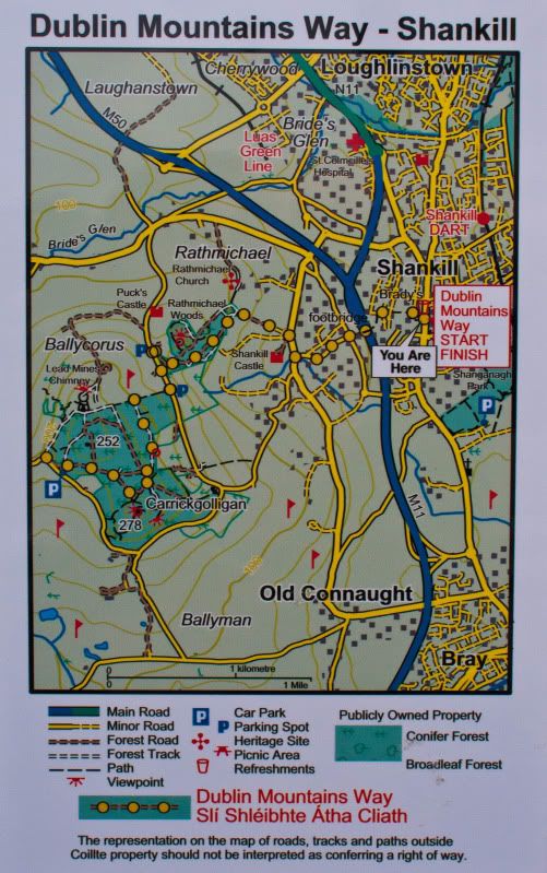
    Here is a photograph of the map board showing the way from Shankill to The Scalp.

    DMW-ShankilltoTheScalp.jpg


  • Registered Users, Registered Users 2 Posts: 1,404 ✭✭✭dogmatix


    According to some maps I viewed from the DLRCC, there is supposed to be a right of way through Ballybetagh wood that puts the walker just a short
    distance from the scalp. If you are coming from glencullen you hook a right at a T-junction instead of heading left down towards Kilternan. This takes you up a narrow (and quiet) country road.

    http://www.kilternan.info/History/fromlibrary.asp
    There is an old and delightful right of way from Ballybetagh House, through Ballybetagh Wood and along the edge of two fields to where
    it joins the main road at the bottom of the Novice’s Hill.


    See also page four of the following -
    http://www.dlrcoco.ie/planning/DevPlan2010_2016/Draft/Appendices/AppendixG.pdf

    I've not yet tried this route so I can't say what it is like or anything.


  • Subscribers Posts: 16,614 ✭✭✭✭copacetic


    thats what i'd assume is the planned route, there is still a fair bit of road walking though. I wonder are they trying to come up with more across land access to avoid the road bits as much as possible, hence the delay? Something like this would be good:

    38cca.jpg


  • Advertisement
  • Registered Users, Registered Users 2 Posts: 507 ✭✭✭Judge


    copacetic wrote: »
    thats what i'd assume is the planned route, there is still a fair bit of road walking though. I wonder are they trying to come up with more across land access to avoid the road bits as much as possible, hence the delay? Something like this would be good:

    Isn't that wood on the bottom right used by paintballers? Could be hazardous!:eek:

    Tried to find the link to no avail but I'm sure a while back there was a motion at a meeting of the Dun Laoghaire Rathdown County Council to secure a right of way for the Dublin Mountains Way through the lands of the Kilternan Sports Hotel. Don't know if it came to anything although as far as I know the hotel is now part of NAMA-land so maybe they are exploring the possibility of getting some public use out of that area but can't announce anything yet.

    Finally caught up on the Tracks and Trails. They must have closed the Ballyedmonduff Road to film that scene of Ken Doherty and Fair City Girl walking down the road saying hello to a local. Never seen it so quiet. I think this episode exposed just how limiting this whole "we won't commission anything without a celebrity in it" mentality that had gripped TV in recent years. With all the prehistoric monuments, the ecclesiastical ruins at St Anns and Rathmichael and the Hell Fire Club, not to mention the geology of Glenasmole and The Scalp, this installment really needed to presented by a historian or a geographer.


  • Closed Accounts Posts: 64 ✭✭trentv


    Just ran the first part as far as the enniskerry road from shankill and i must say i love it. I never knew the trails were so close to where i live. I cant wait to see where the link up will be on the other side of the road and i hope they can keep offroad at any cost. I'd say for the whole time there and back i only passed about 6 people out and its a beautiful day, there must be a way of letting people know that this is right on their doorstep.
    I think it could be improved by taking the "Way" up to the tops of the hills, especially at Scalp, the views from there are amazing and if you dont know that you have to turn off the path to get to it you'll walk straight past it. Its these views and viewing points punctuating a walk that encourage you to walk to the next one so I think if its not on the "Way" there should be a good visible sign to take people up there and back if they want to.
    Still I think the partnership are doing a super job at the moment and its great to see plans like these and the new inter city cycle ways in development to get the nation healthy again, it certainly has started to turn that way and long may it last!


  • Registered Users, Registered Users 2 Posts: 43 campbellu


    Just walked the first "half" of the Wicklow Way Fri/Sat (to Glenmalure) and am resting today, I caught up on Tracks and trails tonight. I think the programme concept is great and interesting but agree the presenters could be the local people with the knowledge, yet if you compare BBC's trails programmes they also use "celebrities" and have added to the viewing figures ?. I think the thread here is really useful and will keep in touch as I plan to do the Dublin Way soon, I will walk the roads and do the 40km in one go. Is there a link where users can comment on the way trails ? do anyone know if comments are acted on ? The Wicklow Way route through the Glendalough National Park is a disgrace, they would be better routing walkers up the spink to get full value from the day rather than the mindlessly? boring uphill forest track with no view and perhaps designed by someone who has "sadistic" tendencies.


  • Registered Users, Registered Users 2 Posts: 507 ✭✭✭Judge


    trentv wrote: »
    Just ran the first part as far as the enniskerry road from shankill and i must say i love it. I never knew the trails were so close to where i live. I cant wait to see where the link up will be on the other side of the road and i hope they can keep offroad at any cost. I'd say for the whole time there and back i only passed about 6 people out and its a beautiful day, there must be a way of letting people know that this is right on their doorstep.
    I think it could be improved by taking the "Way" up to the tops of the hills, especially at Scalp, the views from there are amazing and if you dont know that you have to turn off the path to get to it you'll walk straight past it. Its these views and viewing points punctuating a walk that encourage you to walk to the next one so I think if its not on the "Way" there should be a good visible sign to take people up there and back if they want to.
    Still I think the partnership are doing a super job at the moment and its great to see plans like these and the new inter city cycle ways in development to get the nation healthy again, it certainly has started to turn that way and long may it last!

    Went for a stroll in Barnaslingan this weekend and, to my surprise, found that the route of the Dublin Mountains Way through the woods has been changed. Some of you may be aware that the DMW waymarkers originally took a linear route through the forest along the northern side of the hill before emerging onto the Enniskerry Road in front of The Scalp service station. Now the DMW follows half of the Red Trail through the woods up to the summit overlooking The Scalp before descending steeply down the hill to the north where it joins up with where the old route brought you out onto the road. This is a significant improvement on the old route: the trail now passes through some lovely mature forest before emerging at The Scalp lookout point. The view is tremendous: the cars on the road below look tiny while the Great Sugar Loaf does its usual job of dominating the skyline. A pat on the back is due to all involved in making this alteration.

    I wonder if they might also make a minor change at Carrickgollogan and bring the Way up onto the summit there? The Tracks and Trails programme made a big deal of the view which was strange given it's not on the route as it stands.

    Even before this change was made I would say that the DMW has tried to bag most of the summits on the route with the tops of Three Rock, Two Rock, Tibradden and Montpelier all on the trail. It's not like Wicklow Way which I think I'm right in saying only bags one summit (White Hill) along the entire route?


  • Closed Accounts Posts: 64 ✭✭trentv


    Thats great news that they go up to the top of scalp now, i was only up there again yesterday and by semi-accident ended up at the viewing point looking out on the enniskerry road and sugarloaf etc. what a great view. However i found the trail a little hard to follow, the path disappeared on me a couple of times and i had to track back and try other paths at junctions. Its all part of the fun for me but i'm sure that would discourage some others who aren't used to the ramble.

    Is there any progress where the trail ends at the enniskerry road, or is it still just along the road does anyone know?


  • Registered Users, Registered Users 2 Posts: 507 ✭✭✭Judge


    trentv wrote: »
    Thats great news that they go up to the top of scalp now, i was only up there again yesterday and by semi-accident ended up at the viewing point looking out on the enniskerry road and sugarloaf etc. what a great view. However i found the trail a little hard to follow, the path disappeared on me a couple of times and i had to track back and try other paths at junctions. Its all part of the fun for me but i'm sure that would discourage some others who aren't used to the ramble.

    It's interesting you bring this up as I was considering saying something similar in my last post. The route from the entrance to Barnaslingan to the top of The Scalp is well marked (if anything I think they've overdone it slightly). From the lookout point, however, there are a couple of issues with the waymarking.

    First of all, when I turned round at the lookout point to continue the trail it took me a couple of minutes to figure out which waymarkers were pointing the direction I was to go to next and which were pointing along the route I'd just taken. Having figured it out, it'll be easy the next time but it is a bit confusing. Not really sure how they can fix this though.

    Secondly, the descent from the top of The Scalp is through some dense forest with no well-defined path. There are waymarkers but they are spaced too far apart so you do need to scan the ground to see where the trail is. As one who is well used to hiking unmarked trails, I was able to pick out the route without much difficulty but the more casual walkers may find this problematic. It's not helped by the fact that the trail is on the side of a steep hill at this point. There is maybe a minor risk that someone who loses the way could take a bit of a tumble. In a situation like this where the path is not well defined I would think that best practice should dictate that once you reach a waymarker, the next waymarker should be within line of sight. This is not the case at present.
    Is there any progress where the trail ends at the enniskerry road, or is it still just along the road does anyone know?
    Was curious about that myself so popped my head out onto the road to see if there were any new waymarkers or signs. Nothing to report and the mapboard at the entrance there remains blank.

    Am wondering how realistic this "autumn" opening date for the Way is? I had assumed when I first heard about it that it would be on National Trails Day (Oct 3), especially since that's the last day of operation for the Dublin Mountaineer. But I would have thought there would be an announcement by now and there are still areas of trail to be marked (and built? has SDCC built the new path through Kiltipper yet?).

    I was considering making an attempt to through-walk the entire route in one day either on or close to opening day but the later we get into the year the less feasible this becomes as the daylight hours grow shorter.


  • Registered Users, Registered Users 2 Posts: 1,404 ✭✭✭dogmatix


    Was wandering around Kilternan today and i'm a bit surprised to note that the walking man signs here for the route would seem to have the walker entirely on tarmac from Glencullen to Kilternan. Anyone who knows this road, knows it is narrow, no footpaths and can be very busy at times - and on certain stretches not the safest. I presume the walker is then expected to walk up the main road to Enniskerry before heading up over the scalp.

    I headed up the narrow road towards Killegar to try and find the ballybetagh woods right of way but no luck - the path appears to be blocked by a house and gates at this end. The exit point on the kilternan-enniskerry road (supposed to be roughly opposite the nursery and garden centre) I could not find either.

    I've asked the DLR for information on this and other rights of way nearby (supposed to be another path that goes up behind the "Dublin sports hotel") -
    it would be a pity if the mountain way ended up choosing the easy tarmac option rather then investigate other more scenic and quieter options.


  • Registered Users, Registered Users 2 Posts: 507 ✭✭✭Judge


    This is depressing news. This would suggest it's all road from The Scalp to Three Rock.:mad:

    Is it now waymarked all the way from The Scalp to Glencullen? The new OSI Discovery #50 map shows the route from Glencullen as being:

    Picture1.png

    The final stretch to The Scalp is not shown but it would suggest some sort of routing via the Kilternan Sports and Country Club.

    I note that the article on the DMP website now states the DMW will be 47km in length. When first announced it was supposed to be 38km in length. This suggests that there has been some considerable deviation from the original plan, presumably for the all too familiar reasons.

    I wonder is this in any way connected with the news that the DMP is establishing a consultative forum to engage with local people living and working in the Dublin Mountains?

    Since I've got the crayons out, this would be my preferred route from The Scalp to Three Rock and on to Fairy Castle. Most of it is through forest and also takes in the wedge tomb at Ballyedmonduff:
    Picture2.png


  • Registered Users, Registered Users 2 Posts: 1,877 ✭✭✭liamo333


    If anyone (really) wants to know where the trail goes between The Scalp and Glencullen PM me... Long story:-)


  • Registered Users, Registered Users 2 Posts: 1,404 ✭✭✭dogmatix


    Aye - that would be the preferred route for me also. Note that there has been a mass tree felling at the "Newtown" woods near Glencullen so that wooded stretch is now a WW1 battlefield site. I think this wooded area might be private lands as well, that is outside of Coillte - but I could be wrong here.

    I note that your route tries to follow the ballybetagh woods right of way onto to the kilternan-enniskerry road. This is the very same right of way I was unable to get onto on sunday.

    The walking man sign I noticed is at the junction of the main glencullen-kilternan road and the road up towards Kilegar and directs the walker to the left towards kilternan. I can't say I noticed any other waymark signs. So it would appear it is tarmac all the way from the three rock to the scalp.

    If I get any feed-back from the DLR I will add it to this thread.


  • Advertisement
  • Registered Users, Registered Users 2 Posts: 412 ✭✭IrlJidel


    I've updated the DMW on openstreetmap to include the road sections between Glencullen and Scalp.

    http://osm.org/go/es@F7Wf?relation=286707

    http://osm.lonvia.de/world_hiking.html?zoom=13&lat=53.24832&lon=-6.24762layers=FFBT
    (Dublin Mountains Way is labelled as DMW, The Wicklow Way is labelled as TWW)

    I guessed most of the route between Two Rock and Shankill without actually walking the route so let me know if I've got it wrong. I still need to add the changes in Barnaslingan but I'm missing lots of trails there so if someboby want to go for a jog around the woods and collect a trace let me know ;-)

    In fact if anyone is able to get a trace from Shankill to Two Rock that would be great too.


  • Registered Users, Registered Users 2 Posts: 412 ✭✭IrlJidel


    Look route will be officially launced on Oct 31

    "The Dublin Mountains Way will be officially opened from Shankill to Tallaght on Sunday 31st October. The DMP public lands access map will also be published. "

    http://www.dublinmountains.ie/index.php?id=151

    Looks like Cruagh - Masseys - Hellfire is optional. You walk from Cruagh to what I call 'Conception Corner' ie the viewing point at Killakee then goes though the featherbed forest,

    "Cruagh - Glenasmole
    Leaving Cruagh wood the DMW heads up to the wonderful viewpoint at Killakee and on into Featherbed forest. Leaving the forests there are fantastic views of the Wicklow Uplands, and the route travels down the road to Piperstown over to Glenasmole. "


  • Registered Users, Registered Users 2 Posts: 1,404 ✭✭✭dogmatix


    Clicked on that link and it mentions that the section from Glencullen to Kilternan is not yet waymarked but there are clear walking man posts at one of the junctions at least. I also noticed a blank wooden post further down the Killegar road so I assume they had been planning to route the way down there at some point. The website does mention that this section of the way is still under consultation so hopefully there is still scope to route the way via rights-of-way if they can be clarified.

    I was up around that area again yesterday - this time trying to find the right of way that goes from the small country road over and behind the sports hotel (and supposed to exit at the scalp service station). I don't know what it is like at the scalp end, but the "Killegar" end is blocked with a four foot high substantial iron gate festoned with barbed wire. Not a hopeful sign.

    I got a response to my query from the DLR county council - their response was to point me to the relevent sections of the current county development plan. In other words replying to my query by quoting my own info back at me - not very helpfull. Next step is to e-mail specific councillors I think.


  • Registered Users, Registered Users 2 Posts: 507 ✭✭✭Judge


    IrlJidel wrote: »
    Look route will be officially launced on Oct 31

    "The Dublin Mountains Way will be officially opened from Shankill to Tallaght on Sunday 31st October. The DMP public lands access map will also be published. "

    http://www.dublinmountains.ie/index.php?id=151

    Looks like Cruagh - Masseys - Hellfire is optional. You walk from Cruagh to what I call 'Conception Corner' ie the viewing point at Killakee then goes though the featherbed forest,

    "Cruagh - Glenasmole
    Leaving Cruagh wood the DMW heads up to the wonderful viewpoint at Killakee and on into Featherbed forest. Leaving the forests there are fantastic views of the Wicklow Uplands, and the route travels down the road to Piperstown over to Glenasmole. "

    This is very confusing - is there a path from Hell Fire to Glenasmole as well? :confused:

    Looks to me like they've made an unholy mess of it. :(


  • Registered Users, Registered Users 2 Posts: 412 ✭✭IrlJidel


    Judge wrote: »
    This is very confusing - is there a path from Hell Fire to Glenasmole as well? :confused:

    From what I can gather the Cruagh-Massey-Hellfire is a spur route so it doesn't connect up with the rest of way.
    Looks to me like they've made an unholy mess of it. :(

    Well land-owners and blocked public rights of way have resulted in the mess. Guess they've had to make the best of a bad situation wrt access.

    The whole DMP should be lauded for this great initiative. In particular, I'm very greatful to Mountain Meitheal for all the selfless work they have done on the trails.

    Also, I've noticed a wikipedia entry for the DMW:
    http://en.wikipedia.org/wiki/Dublin_Mountains_Way


  • Registered Users, Registered Users 2 Posts: 1,404 ✭✭✭dogmatix


    Well land-owners and blocked public rights of way have resulted in the mess. Guess they've had to make the best of a bad situation wrt access.
    http://en.wikipedia.org/wiki/Dublin_Mountains_Way[/QUOTE]

    I got news that at least one of the "rights of way" from the ballybetagh road to the enniskerry road is being disputed by a landowner. I suspect the other right of way is also in dispute. Legal action may be pending but given the outcome of a DLR vrs's local landowner action in 2004 and various rights of way actions in wicklow, I would be very pessimistic on a positive outcome from the courts.

    So it is pretty much tarmac + a busy (and unsafe) road all the way from the three rock to the Scalp, at least for now.


  • Registered Users, Registered Users 2 Posts: 19,550 ✭✭✭✭Krusty_Clown


    IrlJidel wrote: »
    I guessed most of the route between Two Rock and Shankill without actually walking the route so let me know if I've got it wrong. I still need to add the changes in Barnaslingan but I'm missing lots of trails there so if someboby want to go for a jog around the woods and collect a trace let me know ;-)

    In fact if anyone is able to get a trace from Shankill to Two Rock that would be great too.
    Hi IrlJidel, I've uploaded a trace of the route from Shankill as far as the R117 (Monastery Road/Kilternan). I ran the route this morning (trace is actually from a Garmin Zumo 550 with Navteq mapping turned off). I have a second trace from my Forerunner if that would be useful?

    I ran the route from Shankill to the Scalp and back again, but only managed to negotiate the route correctly on the way back. It's a lovely route but a few observations for anyone heading that way:
    When leaving Carrigologan there are no sign-posts to point you in the direction of Barnaslingan
    In Barnaslingan as you approach the Scalp viewing point, it's very easy to miss the waypoint directing you away from the viewing point down towards Monastery Road, in which case (like me) you could spend a while wandering and wondering!
    Even when you find the tree-bound waymarker, it's very hard to tell which way to go in the forest, but isn't that all part of the adventure?!
    When you exit onto Monastery Road there are no further signposts at all.

    The crew (DMP? Mountain Meitheal?) have done a wonderful job on the trail into Rathmichael Wood, where they have directed the river bed down the side of the trail, which will make for significantly drier walking in Winter. Also the path up to the smelting tower has been very well managed, with steps, erosion gulleys etc. Big applause.


  • Registered Users, Registered Users 2 Posts: 412 ✭✭IrlJidel


    Hi IrlJidel, I've uploaded a trace of the route from Shankill as far as the R117 (Monastery Road/Kilternan). I ran the route this morning (trace is actually from a Garmin Zumo 550 with Navteq mapping turned off). I have a second trace from my Forerunner if that would be useful?

    Wow thanks for that. Looks like I got the route mostly right from Shankill->Scalp accept for the recent changes in Barnaslingan. I'll adjust that shortly. Thanks again!


  • Registered Users, Registered Users 2 Posts: 19,550 ✭✭✭✭Krusty_Clown


    IrlJidel wrote: »
    Wow thanks for that. Looks like I got the route mostly right from Shankill->Scalp accept for the recent changes in Barnaslingan. I'll adjust that shortly. Thanks again!
    No worries. I'll get to the rest of it at some stage soon. Any guesses as to the entire length? The section I uploaded was just shy of 4 miles.


  • Advertisement
  • Registered Users, Registered Users 2 Posts: 412 ✭✭IrlJidel


    No worries. I'll get to the rest of it at some stage soon. Any guesses as to the entire length? The section I uploaded was just shy of 4 miles.

    The tool here shows I've got 38.6k of trail covered so far.
    http://osm.lonvia.de/world_hiking.html?zoom=13&lat=53.24832&lon=-6.24762&layers=FFB

    I'll need to change it to account for the optional Cruagh->Hellfire spur and include the new path from Featherbed Forest->Piperstown->Glenasmole and the bits I missed in Kiltipper Park.

    Think I'll wait till Oct 31st to see what final route looks like.


  • Registered Users, Registered Users 2 Posts: 412 ✭✭IrlJidel


    Just noticed. Looks like they have the route on site now:

    http://www.dublinmountains.ie/dublin_mountains_way/dublin_mountains_way/


  • Closed Accounts Posts: 1,827 ✭✭✭Donny5


    IrlJidel wrote: »
    Just noticed. Looks like they have the route on site now:

    http://www.dublinmountains.ie/dublin_mountains_way/dublin_mountains_way/

    Why the hell would they distribute it as an image embedded in a PDF?


  • Registered Users, Registered Users 2 Posts: 21,499 ✭✭✭✭Alun


    Donny5 wrote: »
    Why the hell would they distribute it as an image embedded in a PDF?
    Don't know but they're easy to extract. I used PDF-Viewer's export function to convert them to PNG's. If I have time I may stitch them together, calibrate them for Ozi and make a KMZ out of them of anyone's interested? The problem will be generating the calibration points as there's no grid lines on them but I'll probably be able to spot sufficient number of points with known coords to get it done.


  • Registered Users, Registered Users 2 Posts: 1,404 ✭✭✭dogmatix


    I wonder why they have the walker coming down off the three rock near Barnacullia, when they could put the walker down at Newtown? That would save 2km of tarmac walking on a road that can be busy at times.


  • Registered Users, Registered Users 2 Posts: 507 ✭✭✭Judge


    dogmatix wrote: »
    I wonder why they have the walker coming down off the three rock near Barnacullia, when they could put the walker down at Newtown? That would save 2km of tarmac walking on a road that can be busy at times.

    Do you mean via the section of forestry near the pitch 'n' putt course where the wedge tomb is? I wondered about that myself: it is private forestry but the landowner doesn't seem to object to walkers in my experience. It is very mature forest though: perhaps it's due for the chop soon?

    I wonder what the story at Piperstown Gap was that prevented them linking Featherbed Forest into the Hell Fire Wood? The map board at the junction between Cruagh and Massy's clearly shows the Way crossing the Gap into Featherbed Forest which would suggest that plan was well advanced. Objections from landowner or lack of funds to build a path?


  • Advertisement
  • Registered Users, Registered Users 2 Posts: 5,441 ✭✭✭Slogger Jogger


    Its a shame the amount of road walking on the Shankil to 3 Rock stretch. If the roads were quiet then fine but some of these stretches are busy and cars fly around some of those bends...:(


  • Registered Users, Registered Users 2 Posts: 507 ✭✭✭Judge


    Its a shame the amount of road walking on the Shankil to 3 Rock stretch. If the roads were quiet then fine but some of these stretches are busy and cars fly around some of those bends...:(

    Aye. I stand by my earlier assertion that most people will walk Three Rock to Tallaght. The Shankill to Scalp bit will probably make for an entertaining afternoon stroll on occasion though.

    Incidentally, I meant to ask in my earlier post: is the Fort Bridge to Tallaght section now open? Has the Tallaght trailhead been erected? Does anyone know?


  • Subscribers Posts: 16,614 ✭✭✭✭copacetic


    Its a shame the amount of road walking on the Shankil to 3 Rock stretch. If the roads were quiet then fine but some of these stretches are busy and cars fly around some of those bends...:(

    I think they would have been better not opening that section of the 'way' at all. Having a large section of it on narrow busy roads is crazy, I wouldn't advise anyone to walk the roads from kilternan to johnny foxes and on to trail. You'll find yourself having to flatten in against the bushes/walls a fair bit as cars zoom past, especially if cars pass each other near you. Tourist are unlikely to be expecting that on a waymarked route..


  • Registered Users, Registered Users 2 Posts: 5,441 ✭✭✭Slogger Jogger


    Its an accident waiting to happen I'm afraid along some of those sections of road. I only drove some of them a few weeks ago and I didn't see any traffic calming measures which would be necessary if you add walkers to it :(


  • Registered Users, Registered Users 2 Posts: 2,061 ✭✭✭nomdeboardie


    dogmatix wrote: »
    I wonder why they have the walker coming down off the three rock near Barnacullia, when they could put the walker down at Newtown? That would save 2km of tarmac walking on a road that can be busy at times.

    Yes. Or if they do descend to Barnaculla, why not use the paths/lanes going SSE from Taylor's Folley to cut out the Glencullen "L" (I think this was mentioned before) - anyone know if those paths are private?


  • Advertisement
  • Registered Users, Registered Users 2 Posts: 412 ✭✭IrlJidel


    Judge wrote: »
    Aye. I stand by my earlier assertion that most people will walk Three Rock to Tallaght. The Shankill to Scalp bit will probably make for an entertaining afternoon stroll on occasion though.

    Incidentally, I meant to ask in my earlier post: is the Fort Bridge to Tallaght section now open? Has the Tallaght trailhead been erected? Does anyone know?

    I'm not sure, but I remember seeing something on sdcc site for National Trails Day involving Kiltipper Park. Cant find it on sdcc site but did find this:

    http://www.nationaltrailsday.ie/events/dublin/event-details/article/-38d944e49e/


  • Registered Users, Registered Users 2 Posts: 1,404 ✭✭✭dogmatix


    Judge wrote: »
    Do you mean via the section of forestry near the pitch 'n' putt course where the wedge tomb is? I wondered about that myself: it is private forestry but the landowner doesn't seem to object to walkers in my experience. It is very mature forest though: perhaps it's due for the chop soon?

    Aye – that’s the one. I was not aware it was a private forest – that might explain why they did not route that way so. It seems that if there is the slightest possibility of hassle over access they simply route it onto tarmac roads. It would be ideal, especially if they could get access to the Newtown woods, as the road through those woods is nearly opposite the exit off the three rock.

    It’s a nice way down into Glencullen, although I have nearly been brained by wayward golf balls on a few occasions.
    Yes. Or if they do descend to Barnaculla, why not use the paths/lanes going SSE from Taylor's Folley to cut out the Glencullen "L" (I think this was mentioned before) - anyone know if those paths are private?

    I think they are all private access unfortunately .
    copacetic wrote: »
    I think they would have been better not opening that section of the 'way' at all. Having a large section of it on narrow busy roads is crazy, I wouldn't advise anyone to walk the roads from kilternan to johnny foxes and on to trail. You'll find yourself having to flatten in against the bushes/walls a fair bit as cars zoom past, especially if cars pass each other near you. Tourist are unlikely to be expecting that on a waymarked route.

    True – the road from Barnacullia to Glencullen is okay but can be busy and the cars a bit fast. But the stretch from glencullen to Kilternan is very unpleasant with a few narrow and blind sharp bends. And a lot of idiots in expensive fast cars.

    If only they could apply the concept of “compulsory purchase orders” to waymarked trails in the same way they do for roads and motorways.


  • Registered Users, Registered Users 2 Posts: 423 ✭✭foolelle


    dogmatix wrote: »
    If only they could apply the concept of “compulsory purchase orders” to waymarked trails in the same way they do for roads and motorways.

    FACT!!


  • Registered Users, Registered Users 2 Posts: 412 ✭✭IrlJidel


    I noticed they haven't included the Dublin Mountaineer stops in their maps.

    Would make sense to add them even though the bus is seasonal.


  • Registered Users, Registered Users 2 Posts: 507 ✭✭✭Judge


    IrlJidel wrote: »
    I noticed they haven't included the Dublin Mountaineer stops in their maps.

    Would make sense to add them even though the bus is seasonal.

    The route changed in 2010 compared with 2009 though so I suppose they want flexibility in this regard. This also assumes there will be a Mountaineer running next year: the website says they "hope" to be running it again next year. Last year they were much more definite it would run again in 2010. The DMP were only guaranteed funding for 2008 to 2010; it may be their budget will be much more restricted from 2011 given the national finances are banjaxed.

    I notice the DMW page has been updated with links to the maps and estimated timings of the walk: here

    There will also be a published EastWest map, cost €9. A link is provided to the EastWest website but no mention of the map.


  • Closed Accounts Posts: 13,992 ✭✭✭✭recedite


    dogmatix wrote: »
    If only they could apply the concept of “compulsory purchase orders” to waymarked trails in the same way they do for roads and motorways.
    Well, "they" could if "the people" demanded it. Look what the Ramblers in UK have achieved since the 1950's, whereas we have less public access since then.
    dogmatix wrote: »
    According to some maps I viewed from the DLRCC, there is supposed to be a right of way through Ballybetagh wood that puts the walker just a short
    distance from the scalp. If you are coming from glencullen you hook a right at a T-junction instead of heading left down towards Kilternan. This takes you up a narrow (and quiet) country road.

    http://www.kilternan.info/History/fromlibrary.asp
    There is an old and delightful right of way from Ballybetagh House, through Ballybetagh Wood and along the edge of two fields to where
    it joins the main road at the bottom of the Novice’s Hill.

    See also page four of the following -
    http://www.dlrcoco.ie/planning/DevPlan2010_2016/Draft/Appendices/AppendixG.pdf

    I've not yet tried this route so I can't say what it is like or anything.
    I walked it regularly in early1990's; there is an old granite stile (nice testament to the local stonemason's skill) near where it emerges from the forest to skirt along the edge of the golf course. It was commonly used by Glencullen locals wanting to get the bus on the Kilternan road. I see it has been "edited" off the DMW route map, but it is still on the original eastwest mapping "Dublin Mt's." map. Probably now disputed because one or two Celtic Tiger houses have sprung up in the Ballybetagh Woods. You could still walk it discreetly, but much easier to find going from west to east downhill.

    BTW any forestry shown transparent on those DMW maps are privately owned. Darker green is Coillte.
    Judge wrote: »
    I wonder what the story at Piperstown Gap was that prevented them linking Featherbed Forest into the Hell Fire Wood? The map board at the junction between Cruagh and Massy's clearly shows the Way crossing the Gap into Featherbed Forest which would suggest that plan was well advanced. Objections from landowner or lack of funds to build a path?
    Another wasted opportunity and convoluted detour here. Piperstown Gap is used as a route for driving cattle and sheep, and has been since ancient times. In some countries this would make it a right of way. But the logic here seems to be that it is too useful to let walkers on; they should stay on the mountain tops where they won't be in the way.


  • Registered Users, Registered Users 2 Posts: 21,499 ✭✭✭✭Alun


    recedite wrote: »
    Well, "they" could if "the people" demanded it. Look what the Ramblers in UK have achieved since the 1950's, whereas we have less public access since then.
    Maybe we need to organize something like this ...

    http://en.wikipedia.org/wiki/Mass_trespass_of_Kinder_Scout


  • Registered Users, Registered Users 2 Posts: 1,404 ✭✭✭dogmatix


    recedite wrote: »
    Probably now disputed because one or two Celtic Tiger houses have sprung up in the Ballybetagh Woods.

    True - this is currently in dispute between the co.council and the local landowner. Case currently on hold I believe. I don't hold out much hope of a positive result given previous precidents regarding access and rights of way.

    All in all, the stretch from the three rock to the scalp is very disappointing and in some places dangerous.


  • Registered Users, Registered Users 2 Posts: 6,047 ✭✭✭trellheim


    I'd like to add my own, current, impressions of this entire route, having walked most of it for the last few weeks Shankill-Tallaght.

    1. From the pub in shankill you are immediately lost ( there is no marker that should take you out of the pub car park that you are directed to ) but a few minutes of casting around, gettting frustrated in the surrounding lanes sets you right.

    From there on its road till Rathmichael, a nice path through forest, then up into Carrickgollogan, more lovely forest then up Barnaslingan. Now the real negatives start

    Very hard to find the waypoints after the viewpoint on top of the scalp. If it was nighttime you'd miss them, not everyone knows the forest.

    Then its down to the road for walking along a frankly boring pavement, until Kilternan X. Now you take your life in your hands with the walk up to Glencullen as the path vanishes and you are left walking along a narrow road with several blind corners and very high speed traffic.

    DO NOT BRING CHILDREN ON THIS SECTION it's a tragedy waiting to happen. ( there must be a better answer than this route )

    so its on to jonny foxes hang a right then road walking (bore) brings you up the back of three rock on up behind the masts to Fairy Castle, lovely views as always.

    then down to join the wicklow way ( bit confusing as both use the same markings but its only for a mile or so ) , then on over Tibradden, marvellous walking.

    Now down into the valley to the carpark, cross the road, and then high up into Cruagh, all well still, then down off Cruagh and just below Kilakee trouble strikes. the waymarks take you off down to the Hellfire Club and Masseys but you don't want that ...

    so bend back up over the carpark at Kilakee ( no waypoints now which is poo ), back up to the Kilakee forest. There is felling going on here, and a windblown notice saying "the DMW trail is rerouted back around a mile south", so its more road walking.

    So we hoped to pick it up where it came out of the forest ( Kilakee/Piperstown) but there are no markings at all, so rather than get caught faffing around trying to find the Glenasmole entry ( no confidence left in the waymarks now ) we skipped it and just followed the road down to Bohernabreena and thence to the northern carpark of the reservoirs - where the path magically reappears.

    summary : nice walk, interspersed with some really boring road walks. Kilternan to Foxes section should be immediately removed, as it will lead to a needless accident

    Poor signposting led to much less enjoyment as well.

    My 0.02c.


  • Closed Accounts Posts: 2,917 ✭✭✭BarryD


    There are serious deficiencies as regards safety, never mind quality of experience in parts of the route as it stands. You must realise though, that there are powerful interests at play here - there has been significant opposition to the route. The concept has been knocked about since the early 1990's if not before. The fact that the route opened, is significant in it's own way and hopefully can be built upon and improved as a result of public pressure.....

    So write to your newly elected politicians - make it clear that you value public access to the countryside, that you already pay for it in many ways through your taxes, that you will not tolerate the sale of Coillte (who currently provide the better parts of the DMW) to private speculators and that you insist on private landowners allowing a reasonable level of access to the countryside for the greater public good.

    Then things will change and there would be no need for the situation you aptly describe above.

    As far as I know, only the Labour Party has some policy on public access to the countryside but I wouldn't hold out too much hope of any substantial change as FG is historically wedded the other way.


  • Advertisement
Advertisement