Advertisement
If you have a new account but are having problems posting or verifying your account, please email us on hello@boards.ie for help. Thanks :)
Hello all! Please ensure that you are posting a new thread or question in the appropriate forum. The Feedback forum is overwhelmed with questions that are having to be moved elsewhere. If you need help to verify your account contact hello@boards.ie
Help Keep Boards Alive. Support us by going ad free today. See here: https://subscriptions.boards.ie/.
If we do not hit our goal we will be forced to close the site.

Current status: https://keepboardsalive.com/

Annual subs are best for most impact. If you are still undecided on going Ad Free - you can also donate using the Paypal Donate option. All contribution helps. Thank you.

M20 - Cork to Limerick [preferred route chosen; in design - phase 3]

1285286288290291

Comments

  • Moderators, Sports Moderators Posts: 13,034 Mod ✭✭✭✭Cookiemunster


    Am I missing it or is there no drawing or map of the tie in at Patrickswell in todays update?


  • Registered Users, Registered Users 2 Posts: 922 ✭✭✭pajoguy


    Sheet 50 & 51 of 68.

    Tie in to the old N20 looks still up for decision. Note on drawing.


  • Registered Users, Registered Users 2 Posts: 521 ✭✭✭Limerick74


    Looks like interactive mapping starting to work now after struggling with traffic earlier. You need to turn on the layers manually at the moment.


  • Registered Users, Registered Users 2 Posts: 804 ✭✭✭Jayuu


    Can you post a link?
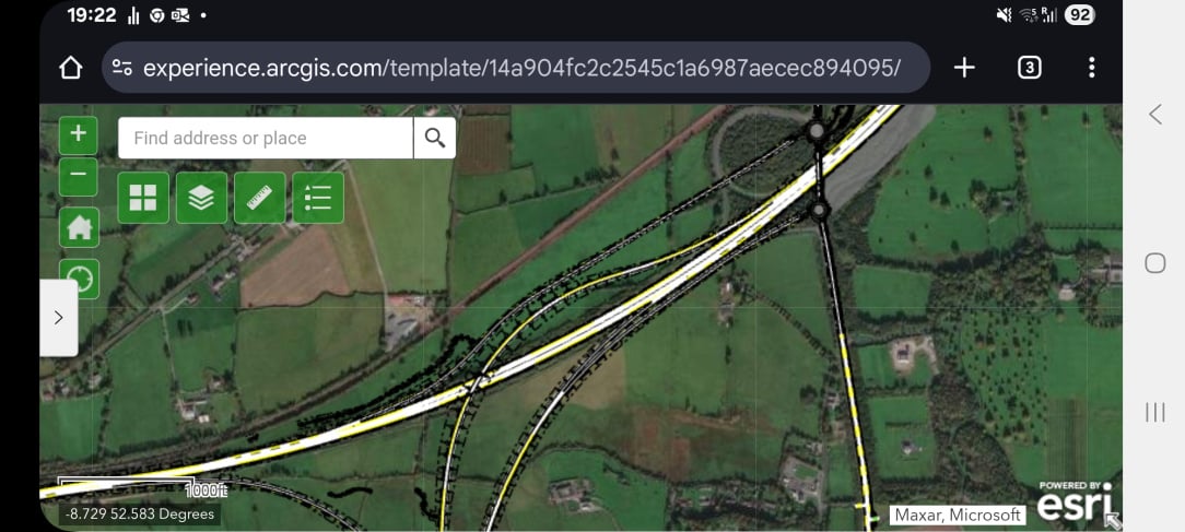
    Also, am I missing something in the layout or is there no N21E > M20S connection? I've looked at the large map and can't seem to see one.


  • Registered Users, Registered Users 2 Posts: 922 ✭✭✭pajoguy


    1000192699.jpg

    This is from the interactive map.

    No Direct M21E to M20S connection.

    Exit M21 to attyflin use flyover and access M20 from slip off southern roundabout.


  • Advertisement
  • Registered Users, Registered Users 2 Posts: 922 ✭✭✭pajoguy


  • Registered Users, Registered Users 2 Posts: 103 ✭✭gooseman12


    Tolls debate kicking off already, and by debate I mean uproar from local TDs over the idea of tolling even being considered

    https://www.echolive.ie/corknews/arid-41652488.html


  • Registered Users, Registered Users 2 Posts: 103 ✭✭gooseman12


    I think the only odd one for me going back over the map is the location of what they are calling the Rathduff exit.

    Down below the Stag statue connecting to a L Road that brings people back up towards Bweeng with a new connector back up to what will be the old road.

    It just seems a strange spot to choose and compared to all the other exits which link to major towns and other national / important routes along the way, a back road to Bweeng just doesn't seem like that necessary a connection.

    But i'm assuming the traffic surveys led the way and can only assume they know what they are about. Possibly the fact that all this is an overlay is also part of it.

    I'm also still not clear what the alternative route for users not allowed on the motorway (L drivers, 50cc mopeds etc) between mourneabbey and blarney is going to be


  • Registered Users, Registered Users 2 Posts: 1,641 ✭✭✭cjpm


    I’m guessing it’s approximately half way between Blarney and Mourneabbey Junctions and it’s also actually a very busy spot


  • Moderators, Science, Health & Environment Moderators Posts: 5,445 Mod ✭✭✭✭spacetweek


    Not sure about the rest of you but this Drawings link leads to a "This item was deleted" page.

    https://www.dropbox.com/scl/fi/bdxfzsbapethz41c7m7pc/June-2025-Drawings.pdf?rlkey=wb1utvcu3t0v3jcd26nizjos5&st=16be1ljd&dl=0

    From the announcement page https://corklimerick.ie/n-m20-cork-to-limerick-project-update-16-06-2025/ :

    "…with traffic flow gains being achieved through the construction of by-passes of Charleville, Buttevant and Mallow initially."

    Since segments will have to open from junction to junction, the sections bypassing those 3 towns will have to be one continuous 36 km section from southeast Mallow to west of Bruree. https://www.google.com/maps/dir/52.1140205%2C-8.6590031/52.4262643%2C-8.6906564/%4052.3983415%2C-8.710407%2C10708m/data%3D%213m1%211e3%214m2%214m1%213e0?entry=ttu&g_ep=EgoyMDI1MDYxMS4wIKXMDSoASAFQAw%3D%3D That's unless they do a Macroom on it and have temporary roundabouts.


  • Advertisement
  • Registered Users, Registered Users 2 Posts: 521 ✭✭✭Limerick74


  • Registered Users, Registered Users 2 Posts: 356 ✭✭rounders


    That junction is actually crazy busy every morning that a lot of traffic goes along the glen road and into Blarney because they can't cross. It's also a common way to get to Grenagh instead of Rathduff so it's kinda killing two birds situation.

    Between here and rathduff the topography gets tricky, rail line is too close and there are more houses to content with near the road


  • Registered Users, Registered Users 2 Posts: 16,633 ✭✭✭✭markodaly


    So, are we looking at 6 months of more talking before the final design is sent to ABP to get approval?


  • Registered Users, Registered Users 2 Posts: 25,424 ✭✭✭✭Kermit.de.frog


    This is a motorway to motorway interchange. Why don't they just put a freeflow link for M21E - M20S? This is what every single continental European country would do.


  • Registered Users, Registered Users 2 Posts: 25,424 ✭✭✭✭Kermit.de.frog


    There should not be any toll on this road. It's a money grab, plain and simple.


  • Registered Users, Registered Users 2, Paid Member Posts: 2,120 ✭✭✭Hibernicis


    I've wondered about the option to commence this project by building the three bypasses ever since Ryan first voiced it. I think your suggestion of one long stretch is the only viable option (three small individual bypasses makes no sense - Ryan's point of reference was the Cashel bypass which was later integrated into the M8 but that was a unique set of circumstances which doesn't translate to the M20). I think the logical starting point is further South than you have it, at the Mourneabbey Junction. This would link it to the existing N20 using a partial construction of the new Mourneabbey junction. Your Northern interlink at O'Rourke's cross makes perfect sense, other than it requires construction of the proposed roundabout which has proven elusive. This would suggest three contracts:

    1 Mourneabbey Junction to Bruree Junction (with a tie in to O'Rourkes Cross) bypassing Mallow, New Twopothouse, the Ballybeg Bends, Buttevant and Charleville. This would reduce the awfulness of the existing Cork-Limerick drive by about 66%, though if completed first would result in the de facto speed limit on the remaining sections being 120kmh (170 if you hurl for Limerick) with a significant increase in RTAs.

    2 Blarney to Mourneabbey Junction

    3 Bruree Junction to Patrickswell

    If they really wanted to split it in four, the first of these (Mourneabbey Junction to Bruree Junction) could be split in two, Mourneabbey Junction to a point North of Buttevant where the M20 crosses the N20, and a second contract from this point to Bruree junction. The only advantage of this is to reduce the size of the contracts, bearing in mind that the Southern section includes the new Mallow East bridge, probably the largest structure on the entire route. The other piece that could be carved out to create a fourth contract is the Attyflyin to Patrickswell area, though I can't see the benefit. The three contract model appears to make more sense.

    At the last webinar, Jari Howard seemed minded to recommend a two contract approach, and a few knowledgable posters here supported this on the basis that two contracts of roughly 40/50 km each was optimal. It will be interesting to see what response is given if the three/four contract approach is questioned at the forthcoming webinar.


  • Registered Users, Registered Users 2, Paid Member Posts: 2,120 ✭✭✭Hibernicis


    From the brochure provided, quite a bit to be done prior to submission to ABP. Could well take 12 months.

    Next Steps

    Following this project update the Project Team will facilitate extensive consultation with property, land owners and other key stakeholders. The business case will undergo Departmental and external review and subject to its approval, a planning application for the project will be submitted to An Bord Pleanála in 2026. In accordance with the Government’s Infrastructure Guidelines (previously known as the Public Spending Code), the preliminary business case is reviewed through an External Assurance Process (EAP) prior to submission to the Major Projects Advisory Group (MPAG) to consider the major public investment proposal. The Department of Transport would then seek Government consent through Cabinet approval. Subject to this Government Approval, the statutory documents including the Environmental Impact Assessment Report (EIAR), Natura Impact Statement (NIS) and the Motorway Order (MO) would then be submitted to An Bord Pleanála by Limerick City and County Council as the lead authority. This would commence the formal statutory planning process (Phase 4)


  • Moderators, Science, Health & Environment Moderators Posts: 14,739 Mod ✭✭✭✭marno21


    “We plan to begin enabling works in 2028, things like service diversions, and then construction takes seven years, so that gives us a completion date of 2035, but we will have the bypasses of Mallow, Buttevant and Charleville done first – so they could be done by 2031 or 2032.

    Quote from @Hibernicis Irish Times link.

    Looks like the central section will be delivered first and the other elements thereafter.

    A reasonable compromise I think. If the whole lot were under construction in one go, there would be significant impacts to journey times along the route with intense online roadworks between Croom and Patrickswell, Mourneabbey and Blarney and at the centre point near Velvetstown that @Hibernicis pointed out. Doing it in phases as what's proposed isn't the end of the world.

    Given how slow things can move around here, having a motorway from O'Rourke's Cross to Mourneabbey bypassing Charleville, Ballyhea, Buttevant, the Ballybeg bends, Newtwopothouse, the accident prone area from Mallow Hospital to Dairygold, Mallow in 2032 would be a great deal. And not only all that bypassed, but no longer having to transit the dross between all those points.


  • Registered Users, Registered Users 2 Posts: 2,713 ✭✭✭KrisW1001


    It would be a complete waste of money. Look at a map of the wider area. N21 runs northeast, M20 runs south. There's effectively no demand for a what would be a near U-turn movement on a longer journey. Anyone wanting to head for Cork will have left M21 long before Attyfin.

    The original M21 design tried to address this by planning to bypass Adare to the south, so that M21E-M20S traffic never reached the start of M20S at Attyfin l. However, that design didn't help people in Adare very much, and it still couldn't fix the basic problem that this is such a huge dogleg that diverting onto a local road to cut the corner will always be quicker.

    Improving/widening R520 and R518 from Newcastlewest to M20 Bruree would be a far better use of money than building a lane over M21 that nobody would ever use.


  • Advertisement
  • Registered Users, Registered Users 2 Posts: 104 ✭✭Pale Red


    The O'Rourke's Cross to NCW is a reasonable secondary road. Very comfortable doing 80 kph (and tempted to do more) for most of its length. There are about four x 100m stretches that you need to dramatically reduce speed and there is no hard shoulder. Lightly trafficked and long straight stretches to overtake if needed. I use most of it to avoid tailbacks in Adare.


  • Registered Users, Registered Users 2 Posts: 1,641 ✭✭✭cjpm


    I would be thinking that the most logical way to stage it would be start at the southern end and work northwards. So you’d start with the highest traffic volumes and move towards decreasing volume areas

    There’s already a massive AADT on the 2+1 section, it’ll be pandemonium if additional traffic is funnelled onto it, albeit temporarily.


  • Registered Users, Registered Users 2, Paid Member Posts: 2,120 ✭✭✭Hibernicis


    Be thankful that the movement is actually catered for at all. If you look at other fork junctions on the network, branch to branch movements are not possible, e.g. M7E to M8S, M7E to M9S. In the case of the M4E to M6W the movement is possible but it also involves leaving the motorway and navigating three roundabouts.


  • Registered Users, Registered Users 2 Posts: 12,826 ✭✭✭✭Red Silurian


    From the Echo live article above

    It is envisaged that the project could be ready for submission to An Bord Pleanála by summer 2026, with a projected building time of approximately seven years.

    So it will be submitted for planning permission in 12 months time and will be built by 2033 + any "delays" of course. My theory is never, but I'll happily be proven wrong


  • Registered Users, Registered Users 2 Posts: 12,826 ✭✭✭✭Red Silurian


    Ireland isn't a continental European country, we have never done things the same and are unlikely to start anytime soon


  • Registered Users, Registered Users 2 Posts: 2,713 ✭✭✭KrisW1001


    It's not like there's no link, it's just that you've got to drive a little out of the way to make the movement.

    And I sometimes wonder what "continental countries" people have driven in. Limited access juctions are everywhere on European motorways, especially where a route forks. M20/M21 is a very clear fork in the road network.


  • Registered Users, Registered Users 2 Posts: 3,693 ✭✭✭hans aus dtschl


    Very little comment here. I'm taking it as a sign the project team is doing a fairly good job: there's very little about this one that's contentious.


  • Registered Users, Registered Users 2 Posts: 922 ✭✭✭pajoguy


    The main bone of contention at the northern end seems to be the removal or not of the off slip at Attyflin southbound.

    When you look at the level of detail in this update you can see why it took so long to get it published. The project team have done a really good job so far


  • Registered Users, Registered Users 2, Paid Member Posts: 1,308 ✭✭✭riddlinrussell


    Anyone know why the active travel route seems to be split in two? Southern section just ends at New Twopothouse and the Northern Section just ends randomly at a Junction?

    Just a quirk on the interactive map? Running on up the old road to Buttevant and connecting in there looks like it would be the most sensible option.

    Boards is in danger of closing very soon, if it's yer thing, go here (use your boards.ie email!)

    👇️ 👇️


  • Advertisement
  • Registered Users, Registered Users 2 Posts: 521 ✭✭✭Limerick74


    Ballybeg Bends would be a challenge with active travel along the N20.


Advertisement