Advertisement
If you have a new account but are having problems posting or verifying your account, please email us on [email protected] for help. Thanks :)
Hello all! Please ensure that you are posting a new thread or question in the appropriate forum. The Feedback forum is overwhelmed with questions that are having to be moved elsewhere. If you need help to verify your account contact [email protected]

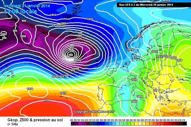
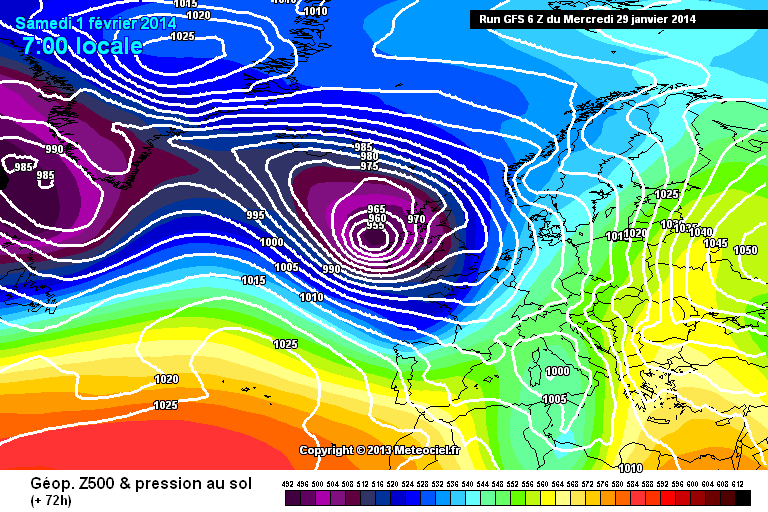
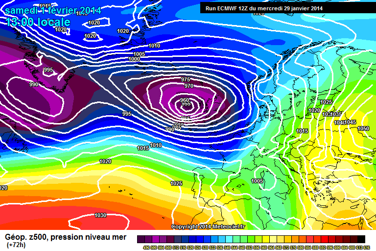
Very strong winds developing south, east; storm watch late Tuesday

  • 29-01-2014 3:20am
    #1
    Registered Users Posts: 14,267 ✭✭✭✭M.T. Cranium


    There was a thread open until a day ago, extending the discussion of the Monday storm into the prospects for a severe storm late Friday 31st into Saturday 1st February.

    This new thread will continue that discussion on the basis of model data this morning, showing the potential for wind gusts reaching 130 km/hr on the west coast, and a very high potential for coastal flooding especially around Galway Bay but more generally on the west and even south coasts, due to the strongest winds overlapping some of the month's highest astronomical tides due to the new moon (30th) at perigee. Rainfalls of 15-30 mm appear likely with some risk of thunder and hail, from mid-day Friday to late Saturday.

    At this early stage, I have selected level 2 although conditions look fairly close to level 1 for the inland and eastern thirds of the country, and could reach level 3 locally on the west coast. Level 2 will apply to counties from Waterford around the west coast to north Ulster.

    This post will be edited after all model runs are completed, but the earlier guidance was quite consistent with a storm maximum around 0600h Saturday with the low centre approaching from the west then moving more northeast after reaching Donegal Bay. Some ensemble members of the GFS model were showing extreme conditions and the general consensus of all models would suggest maximum gusts of 130 km/hr in exposed locations and 110 km/hr fairly widespread. The only updated guidance so far (0320h) is the 48h RGEM which shows a 960 mb low approaching Ireland on Friday at 00z. Further updates will come in soon from the GFS, GME and UK models, and around 0615h from the ECM. This post will be edited from the data shown in those model runs.

    UPDATE 1 _ The 00z GME shows an extreme storm event with a 940 mb low approaching coastal Donegal Bay by late Friday. If this model has support from the bigger models after two consecutive runs I would upgrade the warning to Level 3. It would warrant a high state of alert for the west coast Friday night.

    UPDATE 2 _ The 00z GFS is only slightly less extreme with the low at about 940 mb mid-day Friday filling to 950 mb before landfall (the track is across north-central Ireland then into the Irish Sea). This model would suggest peak gusts of about 115 km/hr but very similar impacts from high tides and waves/swells. Maximum level 2 status is more appropriate to this model. Some perturbations are bound to be stronger.

    UPDATE 3 _ The 00z UKMO appears a touch further north but is about the same intensity as the GFS. Timing on all three models is very similar for maximum gusts to hit around 0300-0900h Saturday.

    UPDATE 4 _ The 00z GEM is fairly similar to the GFS and holds back the full power of the storm until after midnight Friday then unleashes it just as central pressures are filling. It would only require a slight tweak in this model to get to the GME more intense solution.

    FINAL UPDATE _ The 00z ECM follows the same general scenario and now we await more reliable guidance from model runs later today realizing that the system will not actually be forming (out of remnants of a storm system off the southeast coast of the U.S.) until some time later tonight or Thursday morning.


«13456725

Comments

  • Registered Users Posts: 12,778 ✭✭✭✭ninebeanrows


    Trend this morning is to slide this low further south than in recent runs.

    And it is likely the storm will have past peak intensity when it hits.

    Interesting few days ahead.


  • Closed Accounts Posts: 2,693 ✭✭✭Redsunset


    Post deleted.
    If you have nothing of value to add to the thread then don't bother posting.
    It can be deemed as trolling and action will be taken against you.


  • Registered Users Posts: 11,134 ✭✭✭✭maquiladora


    The current primary swell forecast for Inch Co. Kerry for 6am Saturday is 53ft. :eek:


  • Registered Users Posts: 2,342 ✭✭✭red_bairn


    The current primary swell forecast for Inch Co. Kerry for 6am Saturday is 53ft. :eek:

    Time to surf? :D


  • Registered Users Posts: 290 ✭✭Longboard


    The current primary swell forecast for Inch Co. Kerry for 6am Saturday is 53ft. :eek:

    auy9xkv.jpg


  • Advertisement
  • Registered Users Posts: 11,134 ✭✭✭✭maquiladora


    06Z GFS shows the storm at peak strength out at sea on Friday with very strong winds.

    gfs-0-54.png?6

    But weakening by the time it reaches the west coast.

    gfs-0-72.png?6

    We are probably not looking at winds as severe as what we've seen several times already this winter. The most significant aspect will probably be the risk of coastal flooding due to the combination of factors.


  • Registered Users Posts: 145 ✭✭crx===


    The current primary swell forecast for Inch Co. Kerry for 6am Saturday is 53ft. :eek:

    Yeah that's my bigest fear with this particular storm even though peak intensity may be reached at sea the worst swell coincides with peak spring tide which is predicted to be 5.4m at 6.10am at Ballybunion and 5.7m at 5.50am at Galway bay.... looks like costal flooding is almost certain on Saturday morning on low costal areas of the west coast. :(


  • Closed Accounts Posts: 3,548 ✭✭✭Harps


    A constant barrage of storms on the 6z GFS for the next 10 days, the Friday/Saturday one doesn't look too severe though as mentioned coastal flooding looks to be an issue, I don't know much about how those wave height charts work but it looks worrying again along the west coast. After that there's a storm every 24 hours so enjoy the relative calm of the next few days!


  • Closed Accounts Posts: 1,070 ✭✭✭Birroc


    crx=== wrote: »
    Yeah that's my bigest fear with this particular storm even though peak intensity may be reached at sea the worst swell coincides with peak spring tide which is predicted to be 5.4m at 6.10am at Ballybunion and 5.7m at 5.50am at Galway bay.... looks like costal flooding is almost certain on Saturday morning on low costal areas of the west coast. :(

    why is the exciting high tide always at dawn these days! I'll try and get up for it...


  • Closed Accounts Posts: 572 ✭✭✭relaxed


    Birroc wrote: »
    why is the exciting high tide always at dawn these days! I'll try and get up for it...

    was just about to post something similar!

    Why can't it be sunday afternoon so we can all go storm watching with the kids:D


  • Advertisement
  • Closed Accounts Posts: 6,543 ✭✭✭Conmaicne Mara


    The current primary swell forecast for Inch Co. Kerry for 6am Saturday is 53ft. :eek:

    Where does one find this type of information? There was significant damage incurred by the last two tidal events here in Connemara. The sea took a lighthouse, septic tank, fishing gear, roads, cars, flooded houses, much damage and debris on farmland etc.


  • Registered Users Posts: 12,778 ✭✭✭✭ninebeanrows


    Coming right bang on high tide peaks, it does look worrying.

    But yet again this season, it appears it could have been worse, if the intensity occurred just 12 hours later in this system life, we would be in big trouble.


  • Registered Users Posts: 11,134 ✭✭✭✭maquiladora


    Where does one find this type of information? There was significant damage incurred by the last two tidal events here in Connemara. The sea took a lighthouse, septic tank, fishing gear, roads, cars, flooded houses, much damage and debris on farmland etc.

    http://magicseaweed.com/Inch-Reefs-Surf-Report/53/

    Click on Satuday. Highest is 50.5ft now for 9am. It changes a few hours after each GFS run.


  • Registered Users Posts: 1,479 ✭✭✭Hooter23


    Not even a mention on the rte weather there......


  • Registered Users Posts: 5,849 ✭✭✭Storm 10


    Hooter23 wrote: »
    Not even a mention on the rte weather there......

    To early for them to respond yet, they said this morning that we would get severe wind gusts in the West on Friday/Saturday with high seas and coastal flooding.


  • Registered Users Posts: 7,935 ✭✭✭_Whimsical_


    RTE weather forecast have been warning of potentially very stormy condition for friday for a few days now.


  • Moderators, Recreation & Hobbies Moderators Posts: 3,895 Mod ✭✭✭✭Planet X


    Flood alert issued for Cork city by Cork Council.
    CORK CITY TIDAL FLOOD ALERT
    The following flood alert has been issued by Cork City Council on 29th January, 2014

    CORK CITY TIDAL FLOOD ALERT

    The natural cycle of High Tides for the following days is predicted for the times given below:

    Friday 31/01/14 05:37 hours and 17:59 hours

    Saturday 01/02/14 06:24 hours and 18:44 hours

    Sunday 02/02/14 07:09 hours and 19:28 hours


  • Registered Users Posts: 11,134 ✭✭✭✭maquiladora


    Fairly windy for the west/southwest coast on the 12Z GFS. Storm force 90-100 km/h sustained winds shown reaching the coast in places for Saturday morning. Dropping off very quickly as you go inland (also known as the "What storm?/Is this it?" zone)

    69-602UK.GIF?29-12

    Later in the early afternoon, gales for western, southern and eastern coastal areas with windy/blustery conditions inland.

    72-602UK.GIF?29-12

    12Z UKMO seems to have a slower/weaker evolution. So nothing nailed down just yet.


  • Registered Users Posts: 5,068 ✭✭✭Iancar29


    90-100 km/h sustained winds shown reaching the coast in places for Saturday morning. Dropping off very quickly as you go inland (also known as the "What storm?/Is this it?" zone)

    Quote of the DAY!:pac::D


  • Registered Users Posts: 2,342 ✭✭✭red_bairn


    Iancar29 wrote: »
    Quote of the DAY!:pac::D

    Yeah. I'll go for a walk and be like skippin' down the road and suddenly whooooooosh! :D Blown down by the back hand of mother nature =(


  • Advertisement
  • Registered Users Posts: 40,055 ✭✭✭✭Sparks


  • Registered Users Posts: 12,778 ✭✭✭✭ninebeanrows


    I think UKM looks quite strong when it hits land.

    Not a great chart coupled with the high tides and storm surge.

    Few more changes to come though in the next 48 hours.

    UW72-21.GIF?29-17


  • Closed Accounts Posts: 6,466 ✭✭✭Lumi


    Galway City Council have also issued and advisory regarding potential flooding along quays and shorelines in the city over the next number of days
    "Based on current weather forecasts, the highest risk is at high tide on Saturday at 5.47am."


  • Registered Users Posts: 6,315 ✭✭✭sunbabe08


    CORK CITY TIDAL FLOOD ALERT
    The following flood alert has been issued by Cork City Council on 29th January, 2014

    CORK CITY TIDAL FLOOD ALERT

    The natural cycle of High Tides for the following days is predicted for the times given below:

    Friday 31/01/14 05:37 hours and 17:59 hours

    Saturday 01/02/14 06:24 hours and 18:44 hours

    Sunday 02/02/14 07:09 hours and 19:28 hours


    here we go again


  • Registered Users Posts: 261 ✭✭aboyro


    Just noticed this yesterday

    http://www.met.ie/news/display.asp?ID=237

    but also the M6 bouy is now drifting out there somewhere


  • Registered Users Posts: 12,778 ✭✭✭✭ninebeanrows


    ECMWF has it weakening as it approaches but still a fair gradient is likely across the country.

    Big waves powering into the west coast.

    ECM1-72.GIF


  • Registered Users Posts: 14,267 ✭✭✭✭M.T. Cranium


    Holding steady would be my overall assessment of the 12z model runs, landfall appears to be most likely over Mayo around 0700h but possibly delayed to 0900h by looks of ECM. Slight southerly trend to this track but not enough to suggest any diminished concerns from about Westport south. Donegal not in the strong winds at all, Sligo, north Mayo and Leitrim might have a gradient situation at landfall, so we'll get some interesting contrasts in observations it would seem. Glad to read that Galway, Cork and other local authorities are preparing well in advance and think they are correct to assume Saturday morning would be the high tide of most concern. In theory this one could be worse than anything seen in January for coastal flooding, it is more aligned with the highest astronomical tides as well as presenting a nasty sea state. Would suggest also that the Kerry coasts might see very severe conditions and perhaps the strongest winds this time.

    Comes a few hours late to impact on our January contest where max wind gusts were sought, but onset may be early enough to threaten the current value of 72 knots, eventually would think 75-80 knot gusts might be seen on Saturday morning from this one at either Mace Head or Valentia, Sherkin Island. Belmullet might be challenged to reach 60 on the suggested track, possibly well in advance of landfall. Very squally potential ahead of this low as coldest air rotates well to south of centre and thus atmosphere very unstable over south coast Friday afternoon and evening.


  • Closed Accounts Posts: 1,463 ✭✭✭Mr Cumulonimbus


    Holding steady would be my overall assessment of the 12z model runs, landfall appears to be most likely over Mayo around 0700h but possibly delayed to 0900h by looks of ECM. Slight southerly trend to this track but not enough to suggest any diminished concerns from about Westport south...........

    Hmmm, worrying again for Westport. Bertra beach (arrowed) took a right smashing in the storms earlier this month. Acts as a barrier for locations further east. Tides were meant to have been 2 metres over the predicted levels in the area, hence all the damage done. There's a 5.0m tide predicted for Westport at 6.17am on the morning of the 1st.

    291359.jpg


  • Registered Users Posts: 11,134 ✭✭✭✭maquiladora


    hs.nwe.69.png


  • Advertisement
  • Closed Accounts Posts: 1,087 ✭✭✭Spring Onion


    There seems to be a fair few posters in the weather forum from Galway. I think we should all meet up at 6am on Saturday morning (Feb 1) at Blackrock diving board to watch the storm surges in the high tide. I cannot think of a better way to start the Spring.
    Heck while we're at it, we might as well strip off all our clothes, rub our bodies with goose fat and frolic in the surf while screaming like little girls...

    Who is with me?!?


This discussion has been closed.
Advertisement