Advertisement
If you have a new account but are having problems posting or verifying your account, please email us on hello@boards.ie for help. Thanks :)
Hello all! Please ensure that you are posting a new thread or question in the appropriate forum. The Feedback forum is overwhelmed with questions that are having to be moved elsewhere. If you need help to verify your account contact hello@boards.ie
Hi all! We have been experiencing an issue on site where threads have been missing the latest postings. The platform host Vanilla are working on this issue. A workaround that has been used by some is to navigate back from 1 to 10+ pages to re-sync the thread and this will then show the latest posts. Thanks, Mike.
Hi there,
There is an issue with role permissions that is being worked on at the moment.
If you are having trouble with access or permissions on regional forums please post here to get access: https://www.boards.ie/discussion/2058365403/you-do-not-have-permission-for-that#latest

Tom Tom Map Corrections

13

Comments

  • Moderators, Home & Garden Moderators, Technology & Internet Moderators Posts: 24,789 Mod ✭✭✭✭KoolKid


    ultwen wrote: »
    Hi koolkid

    Where you have the red mark is correct.
    If your driving on Chapel farm wood and you come to the junction you can go left on c.f. avenue or straight on c.f. park , but you can no longer go right on to c.f .avenue

    If you look on google street view you will be able to see the bollards,
    hope this makes sense

    Thanks.
    Report sent.


  • Moderators, Home & Garden Moderators, Technology & Internet Moderators Posts: 24,789 Mod ✭✭✭✭KoolKid


    Correction Type : Turn restriction
    City : Dublin city
    Road Name: James Joyce Bridge
    Co Ordinates: [FONT=Calibri, Verdana, Helvetica, Arial]53.346882,-6.282506[/FONT]
    Description: There is no right turn onto Ellis Quay from the James Joyce Bridge as you drive northwards towards Blackhall Place
    Corrected via MapShare. Please do likewise.


  • Closed Accounts Posts: 6,824 ✭✭✭Qualitymark


    koolkid wrote: »
    Corrected via MapShare. Please do likewise.

    koolkid, I've given up on MapShare, since the corrections don't seem to be changed by TomTom. Maybe they wait for a significant number of people to make the correction or something, but the corrections I've put in haven't been used.


  • Moderators, Home & Garden Moderators, Technology & Internet Moderators Posts: 24,789 Mod ✭✭✭✭KoolKid


    Mapshare is based on volume. That's one of the reasons I started this thread.
    I have also changed it as a trusted source.If it doesn't appear as a patch I will chase it up.


  • Closed Accounts Posts: 6,824 ✭✭✭Qualitymark


    koolkid wrote: »
    Mapshare is based on volume. That's one of the reasons I started this thread.
    I have also changed it as a trusted source.If it doesn't appear as a patch I will chase it up.

    Okeydoke, I'll add both the northwards right-hand turn from James Joyce Bridge and the wrongly-named Harold's Cross Road tomorrow so.


  • Closed Accounts Posts: 6,824 ✭✭✭Qualitymark


    Right, have done that.

    Incidentally, it would be a good idea to change the wording of "Is the highlighted section correct" in the dialogue used for changing street names to "Is the highlighted section the one you wish to change". As it is, it leads to a confusing loop: "Is it correct? No! That's why I want to change it!"


  • Registered Users, Registered Users 2 Posts: 1,354 ✭✭✭gebbel


    There are 2 new stretches of road on this route that are not updated on the latest maps. How can I can report them on mapshare?


  • Moderators, Home & Garden Moderators, Technology & Internet Moderators Posts: 24,789 Mod ✭✭✭✭KoolKid


    Not easily done via Mapshare.
    If you post some detail here with some map shots I will send a detailed report to TomTom .


  • Registered Users, Registered Users 2 Posts: 4,780 ✭✭✭JohnK


    Hi Koolkid, was out in Crosshaven in Cork yesterday and when I wanted to plot a route from there to Kinsale it started by taking me up Haye's Hill and then telling me to take a left at the top of the hill on Middle Road however arrows painted on the road seem to indicate this would be going the wrong way on a one way street. There were no signposts that I saw saying you could or couldnt go left only the arrow painted on the road.

    If you look below on google maps, and just go forward one step then pan to the left you should be able to see the road markings. Seems to be a bit of an odd road in that it does appear to be a two way road a bit further back the road on the left. Also, if you follow Middle Road in the direction of the arrows you'll see at the end where it meets Lower Road there is "No Entry" markings for people trying to get on at that point which would seem to also indicate its a one way road.

    http://maps.google.com/maps?f=q&source=s_q&hl=en&geocode=&q=crosshaven,+ireland&sll=37.0625,-95.677068&sspn=33.489543,72.421875&ie=UTF8&hq=&hnear=Crosshaven,+County+Cork,+Ireland&ll=51.802813,-8.297336&spn=0,0.00221&t=h&z=19&layer=c&cbll=51.802718,-8.297228&panoid=bc8RClGZtVWA9YcfhV1wRQ&cbp=12,314.7,,0,31.64

    Hope thats somewhat clear :D


  • Moderators, Home & Garden Moderators, Technology & Internet Moderators Posts: 24,789 Mod ✭✭✭✭KoolKid


    Looking at map v860
    middleroaddv.png
    it appears
    Middle Road from Church Road to Haye's Hill is 2 way & Middle Road from Haye's Hill to Lower Road is one way Northbound.
    Are you saying all Middle Road should be one way Northbound


  • Advertisement
  • Registered Users, Registered Users 2 Posts: 4,780 ✭✭✭JohnK


    No, not the entire road but the one-way starts slightly before the junction with Haye's Hill so crucially it means you cant make a left when you come up the hill. I tried to mark it on the attached image but basically it seems the tt maps see the oneway starting at the green line but in reality it starts closer to the red line.

    143836.png


  • Moderators, Home & Garden Moderators, Technology & Internet Moderators Posts: 24,789 Mod ✭✭✭✭KoolKid


    OK I gothcha now.
    Ill get a report done up for this..


  • Registered Users Posts: 9 helvete


    anyone notice that there is no J12 on the M50, has this been reported too? also i think it was mentioned here in regards to the speed limit on the M50 in sections is 120 on the maps but 100 on the road and there looks to be in the future a speedtrap near J12 northbound


  • Moderators, Home & Garden Moderators, Technology & Internet Moderators Posts: 24,789 Mod ✭✭✭✭KoolKid


    M50 J12 Is Ballycullen Road
    It is showing here on map v860
    m50j12dv.png


  • Registered Users Posts: 9 helvete


    ok so on my unit, it does not show M50 J12, like it does for others, and doesn't show the connecting roads to it, unless i zoom right in, so maybe thats why i'm missing it, cheers koolkid!!

    also one correction to report:

    Correction Type : Roundabout Missing
    City : West County Dublin
    Road Name: Ballycoolin Road
    Co Ordinates: 53.403993,-6.358767
    Description: Roundabout is missing, is a permanent change


  • Registered Users, Registered Users 2 Posts: 246 ✭✭jammer84


    Hi Koolkid,

    Not sure if these are any use... I don't have a gps device yet so these may be inaccurate, however going by the routeplanner online (not sure if it is exact match to the GPS software) I have noticed some fixes for Ballina, Co. Mayo. Please see attachments.

    From red squares to red squares I have identified the new one way system in place in town the last few months.

    Bridges.jpeg
    • On the bridges, they reversed the one way system so you will see the route is now going clockwise.
    • On Pearse street, from the middle of town until nearly down to Walsh street, this is made one way from the entrance to the car park beside Penny's to the middle of town.
    • From the middle of the town, to Barrett Street is now one way going towards the bridges.
    • On hill street you go up the hill now instead of down the hill, casement street you can only go towards bury street and O'Rahilly street you go down to the middle of the town instead of up.
    Molloy Terrace.jpeg
    • There is a crossroads at the top of water lane
    • There is a road that goes from here up to the Foxford road (left at crossroads if coming up from Barrett Street) which has always been there. They have reversed the one way now so you go from the cross roads up to the Foxford road. (not on maps)
    • The new road that goes from crossroads as above, straight through the junction though to the Foxford road is a two way road (not on map either)
    • Water lane is a one way from Barrett street up to the cross road
    • Molloy Terrace is now a one way from the junction after you turn off the Foxford road down to Water lane.

    If you need more detail, let me know and I'll see if I can improve screenshots, etc. This was very quickly put together so may not make too much sense and may be quite messy :-)


    EDIT:The have just made the section between the green squares on bridges.jpg two way again...


  • Registered Users, Registered Users 2 Posts: 4,780 ✭✭✭JohnK


    Not so much a correction as an addition but theres a carpark by Grand Canal Square that doesnt seem to be in the TomTom database. Was looking for parking for a nearby hotel and it wasnt listing this carpark at all.

    http://www.q-park.ie/tabid/425/qparkParkingLocatorvw3443/parkingDetail/ParkingID/1880/language/en-US/Default.aspx


  • Registered Users, Registered Users 2 Posts: 452 ✭✭Mandzhalas


    Housing estate where i live is missing.Loads of people complained to me that they can't find estate simply because it is not on the map.Estate was build 7 years ago,never been put on satnav maps.and its rather big.About 60 houses.Its located in Bunclody,Co.Wexford

    http://i1138.photobucket.com/albums/n527/mandzhalas/oldforest1.png


    http://i1138.photobucket.com/albums/n527/mandzhalas/oldforest2.jpg

    oldforest1.png


    oldforest2.jpg


  • Registered Users, Registered Users 2 Posts: 815 ✭✭✭mickeyboymel


    gebbel wrote: »
    There are 2 new stretches of road on this route that are not updated on the latest maps. How can I can report them on mapshare?


    Ok I might be able to help here, there are three sections of road between Mullingar and Delvin on the N52 which I have tried to report several times, but in all three cases it is new road with new junctions so I cannot seem to do it from my device.

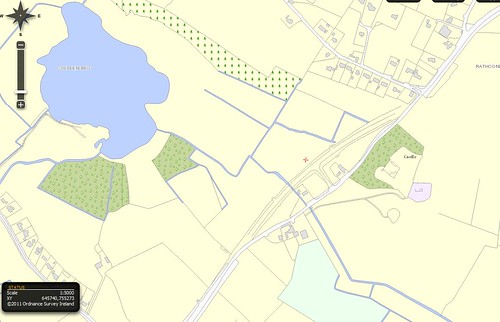
    1: Rathconnell Area: The first of a two phase realignment which was opened last year and can be seen clearly on the OS map as proposed. There is a new T junction and link road to the old section.

    5466534305_f90ea966dc.jpg
    Rathconnell by mickeyboymel, on Flickr
    TOMTOM Route Start Finish Here


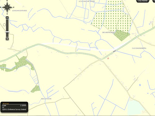
    2. Cloughan Macetown Realignment opened 4 years ago and again shown in white on the OS Map, together with new T Junction and link road onto old section.

    5467130100_cf705bac88.jpg
    Cloughan by mickeyboymel, on Flickr

    TomTom Route Start Finish HERE

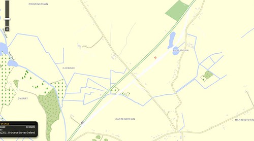
    3. Billistown Realignment opened at least 8 to 9 years ago and never updated on any map, again shown in white and displaying the complete redesign of the crossroads (Caddagh).

    5466530189_34031dba59.jpg
    Billistown by mickeyboymel, on Flickr

    TOMTOM Route Start Finish Points HERE


  • Advertisement
  • Registered Users, Registered Users 2 Posts: 815 ✭✭✭mickeyboymel


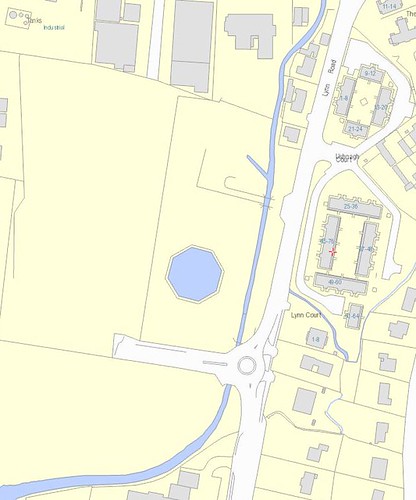
    R400 Lynn Road Mullingar - New Offset Roundabout: It goes nowhere but is considerably offset from the line of the road especially when approaching from the south.

    Also in the image the area marked Ushnagh Court appears on the maps as Lynn Road even though it is a gated community and also, and the internal roadway is not complete as it only shows the upper loop on the map.

    5467260892_544c1323b2.jpg
    Lynn Road by mickeyboymel, on Flickr

    TOMTOM Approx Location Here


  • Registered Users, Registered Users 2 Posts: 1,354 ✭✭✭gebbel


    N52 from Mullingar to Delvin. 3 new sections of road not included in the latest map. 1st new section is on the Mullingar side of Rathconnell, 2nd section is 3km further on towards Delvin, and the final section is just west of Delvin itself.


  • Moderators, Home & Garden Moderators, Technology & Internet Moderators Posts: 24,789 Mod ✭✭✭✭KoolKid


    I'm not familiar with this area. To get this reported I need you post a screen shot showning new road on existing layout.


  • Registered Users, Registered Users 2 Posts: 815 ✭✭✭mickeyboymel


    He is talking about the three sections of road which I reported in post #120


  • Moderators, Home & Garden Moderators, Technology & Internet Moderators Posts: 24,789 Mod ✭✭✭✭KoolKid


    In that case a report has already been sent to TT/TA.


  • Closed Accounts Posts: 6,824 ✭✭✭Qualitymark


    A business at the postcode BT33 0LU in Dundrum, Co Down, Northern Ireland has told me that they're constantly getting calls from lost TomTom users who have been wrongly navigated to an address in Newcastle. They warned me not to enter the postcode in the TomTom, but said it works ok in Garmins, etc.

    I don't know how to correct this, and am logging it here.


  • Advertisement
  • Moderators, Home & Garden Moderators, Technology & Internet Moderators Posts: 24,789 Mod ✭✭✭✭KoolKid


    That's one for TA directly.


  • Closed Accounts Posts: 6,824 ✭✭✭Qualitymark


    KoolKid wrote: »
    That's one for TA directly.

    TA?


  • Moderators, Home & Garden Moderators, Technology & Internet Moderators Posts: 24,789 Mod ✭✭✭✭KoolKid


    Tele Atlas.
    Ill pass it on, but POIs wouldn't be high priority ..


  • Closed Accounts Posts: 6,824 ✭✭✭Qualitymark


    KoolKid wrote: »
    Tele Atlas.
    Ill pass it on, but POIs wouldn't be high priority ..

    KoolKid, this isn't a question of POIs, it's a question of an incorrect address.

    Warned by the proprietor, I didn't enter the shop's post code, but instead entered its actual street address - correctly, of course, 8 Main Street, Dundrum, Co Down, but in the fantasy world of Thatcherite geographers where the counties no longer exist, this is given as Main Street, Dundrum, Newcastle.

    The TomTom map first brought me to Newcastle, Co Down, where it trapped me for some 30 minutes in a continuing circle as it tried to force me through a non-existent right turn. Finally I defied it and took a straight road. It then brought me to Main Street all right - but Main Street, Newcastle.

    I reset it for the 'city' of Dundrum, and it brought me to Dundrum, where it led me up into a council estate in the back of the village, apparently under the impression that this was the city centre.

    I turned around and went down, and found my own way to Main Street, and found the place I was going to.

    Not one of TomTom's more stratospheric performances.


  • Moderators, Home & Garden Moderators, Technology & Internet Moderators Posts: 24,789 Mod ✭✭✭✭KoolKid


    Ahh.. sorry got it now.
    Can you tell me what map version your using?
    Trying this on v865 the post code brings me to Newcastle .
    If I search Dundrum I get 2 (Tassagh) and ( Killard)
    If I search Main Street it Brings me to Main Street between Railway Street & Donard Place. Is this the correct location?


  • Advertisement
  • Moderators, Home & Garden Moderators, Technology & Internet Moderators Posts: 24,789 Mod ✭✭✭✭KoolKid


    Thanks. Ill get something together & over to them tomorrow.


  • Closed Accounts Posts: 6,824 ✭✭✭Qualitymark


    Thanks, KoolKid - maybe ask them to check the no-right-turn in Newcastle too?


  • Moderators, Home & Garden Moderators, Technology & Internet Moderators Posts: 24,789 Mod ✭✭✭✭KoolKid


    I will put it down. Make that correction on your device as well,and select share.


  • Closed Accounts Posts: 6,824 ✭✭✭Qualitymark


    My TomTom Go 520T seemed to have been re-educated to stop its habit of trying to make me turn right through a row of bollards between Stephen's Green and Merrion Row, but last week it did it again.


  • Moderators, Home & Garden Moderators, Technology & Internet Moderators Posts: 24,789 Mod ✭✭✭✭KoolKid


    I'm still pursuing that one.:D;)


  • Closed Accounts Posts: 6,824 ✭✭✭Qualitymark


    I've corrected it for MapShare, but this time when updating didn't get any message saying "You have MapShare corrections, do you wish to share them", or whatever.


  • Registered Users, Registered Users 2 Posts: 304 ✭✭daphil


    KoolKid wrote: »
    I'm still pursuing that one.:D;)

    Hi KK,
    how do you get TT/TA to listen when you supply corrections ? I have submitted an error on a couple of occasions in the past and I see from my map download today that the problem is still there.
    The "hopefully" attached screen shot shows where Dublin St passes under the overpass in Blackpool Cork. The map shows Dublin Street coming to a sudden stop, where in reality it runs into Thomas Davis St. Many,many years ago, the road was closed for work on the overpass, but it has been open FOR YEARS.
    How can I get this corrected ?. It is one of the routes from Limerick to Cork and a quite important route.
    Thanks,
    Dave
    Cork.


  • Moderators, Home & Garden Moderators, Technology & Internet Moderators Posts: 24,789 Mod ✭✭✭✭KoolKid


    Getting map corrections propagated is quite a chore at time, even for me ,being a tester.
    Can you provide me with co ordinates & map version for that.


  • Registered Users, Registered Users 2 Posts: 304 ✭✭daphil


    Sorry, how do I get the co-ordinates. The map vers is V 870.3406, new out today.
    Dave


  • Advertisement
  • Moderators, Home & Garden Moderators, Technology & Internet Moderators Posts: 24,789 Mod ✭✭✭✭KoolKid


    Its ok I got them.
    Ill send in a report on it.


  • Registered Users, Registered Users 2 Posts: 304 ✭✭daphil


    Thanks


  • Closed Accounts Posts: 6,824 ✭✭✭Qualitymark


    Drove to Tara yesterday, and the TomTom still doesn't have the POI correct; rather than the Hill of Tara (centre of Ireland, major tourist destination), the satnav brings you to a little shop called Tara na Rí a couple of kilometres away. You have to retrace your drive and go through a couple of roundabouts signposted for Tara to get to the hill of the High Kings.


  • Closed Accounts Posts: 6,824 ✭✭✭Qualitymark


    The TomTom map for Dublin Port hasn't included major changes, and attempts to drive you through closed-off roads as you search for Terminal 1 and the ferry.

    And by the way, it's also still trying to get drivers to turn right through a line of bollards from Richmond Street into Lennox Street in Rathmines. (This permanent barrier is visible on Google Maps.)


  • Moderators, Home & Garden Moderators, Technology & Internet Moderators Posts: 24,789 Mod ✭✭✭✭KoolKid


    Map v870 Quality mark?


  • Registered Users Posts: 12 Track42


    KoolKid wrote: »
    Map v870 Quality mark?

    Map v870 provides the same two routes described by “Qualitymark”.

    If you take the “official” route to the ferry terminals in Dublin Port (from the direction of the East Link Bridge), by following the road signs on East Wall Road, you will be directed to bear left shortly before the road reaches the M50 tunnel and on to Tolka Quay Road and the terminals via Promenade Road .
    The TomTom route takes you off the East Wall Road much earlier, taking a right turn into Alexandra Road (this seemed to be unobstructed when I drove past it in May), then on to Tolka Quay Road. It seems to be a more direct route, but perhaps access to the ferry terminals is blocked somewhere along the way.

    With regard to the route that includes a right turn from Lennox Street to Richmond Street, this can be corrected by using Mapshare (though I think that it requires reports from four or five devices before an error is eventually corrected on a new version of a map). However, Mapshare isn’t available to users of any of the new devices that use the My TomTom utility.


  • Closed Accounts Posts: 6,824 ✭✭✭Qualitymark


    I've reported it a bunch of times on Mapshare. Bored with doing it now.


  • Closed Accounts Posts: 6,824 ✭✭✭Qualitymark


    It seems really strange that TomTom Points of Interest don't include the NCT centres. Every driver is going to visit these once a year once their car is a few years old. And heaven knows the online maps on the NCT site aren't helpful.


  • Registered Users Posts: 9 helvete


    any idea on how long it will take to have the new N2-N3 link road near ballycoolin included on new maps?


  • Advertisement
  • Moderators, Home & Garden Moderators, Technology & Internet Moderators Posts: 24,789 Mod ✭✭✭✭KoolKid


    Can you send me any more detail on that . Location and what it should be like etc....


Advertisement