Advertisement
Help Keep Boards Alive. Support us by going ad free today. See here: https://subscriptions.boards.ie/.
If we do not hit our goal we will be forced to close the site.

Current status: https://keepboardsalive.com/

Annual subs are best for most impact. If you are still undecided on going Ad Free - you can also donate using the Paypal Donate option. All contribution helps. Thank you.
https://www.boards.ie/group/1878-subscribers-forum

Private Group for paid up members of Boards.ie. Join the club.
Hi all, please see this major site announcement: https://www.boards.ie/discussion/2058427594/boards-ie-2026

Oddities of Irish Infrastructure

12357

Comments

  • Registered Users, Registered Users 2 Posts: 83 ✭✭Enbee


    Colmgogan wrote: »
    Here's one!

    Spending 2-5 (Nobody really knows) Billion euro on a tunnel to join
    Connolly and Heuston station when there is already a perfectly good existing tunnel doing exactly the same thing for free!!! Then IE's blatant avoiding of the question....
    Mind Boggling...

    You can read several critiques of this well-intentioned (but ultimately short-termist) proposal here:

    http://www.boards.ie/vbulletin/showthread.php?t=2055663565


  • Registered Users, Registered Users 2 Posts: 267 ✭✭Lifelike


    Enbee wrote: »
    You can read several critiques of this well-intentioned (but ultimately short-termist) proposal here:

    http://www.boards.ie/vbulletin/showthread.php?t=2055663565

    They should open the Phoenix Park tunnel, but not as a replacement for the Interconnector. The main reason for that tunnel is to relieve congestion on the Loop Line Bridge.


  • Registered Users, Registered Users 2 Posts: 1,321 ✭✭✭Trick of the Tail


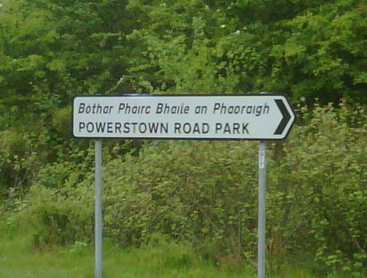
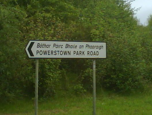
    Clonmel, Co. Tipp, these signs are facing each other and point to the same road:

    roadpark.jpg

    ParkRoad.jpg

    Spot the 'deliberate' mistake?

    :)

    Andy.


  • Registered Users, Registered Users 2 Posts: 1,321 ✭✭✭Trick of the Tail


    murphaph wrote: »
    Abandoned motorways are almost unheard of in Ireland.

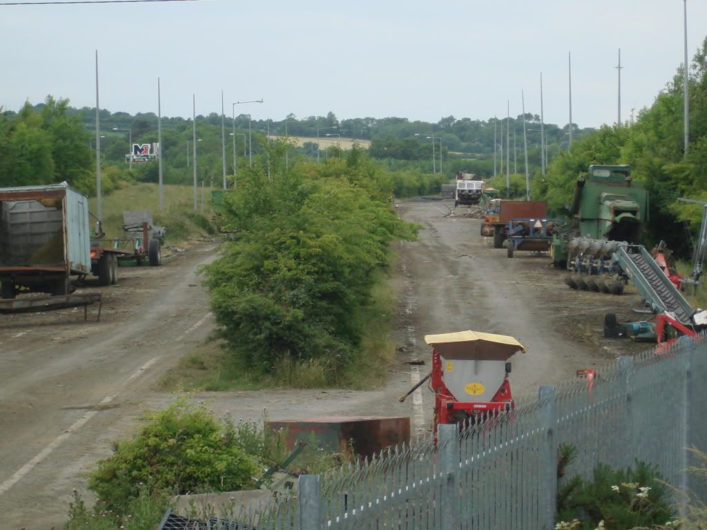
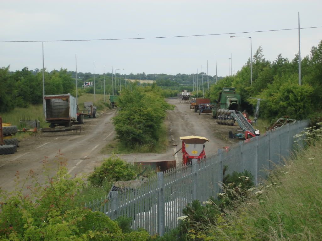
    Here's one:

    DSC00152.jpg

    DSC00154.jpg

    Guess where!

    A.


  • Registered Users, Registered Users 2 Posts: 820 ✭✭✭Jayuu


    Is this part of the Balbriggan by-pass? I can see a sign for the M1 business park in the background.


  • Advertisement
  • Registered Users, Registered Users 2 Posts: 1,321 ✭✭✭Trick of the Tail


    Yep, thats a good clue. Thats the bit referred to in the post I quoted; Runs from the R132 towards the present site of J5, on the eastern side of the M1.

    Seems to have been taken over by the farmer to store/dump his old machinery! Looks a bit eerie though when you look along it.

    A.


  • Registered Users, Registered Users 2 Posts: 577 ✭✭✭Typewriter


    EDIT: Yeah what he said. :o


  • Registered Users, Registered Users 2 Posts: 955 ✭✭✭Pot Noodle =


    6993930.jpgThere is half of a railway bridge over the strawberry beds what happened to the rest of it


  • Registered Users, Registered Users 2 Posts: 7,588 ✭✭✭Bluetonic


    alinton wrote: »

    Guess where!

    A.
    Same place as described in post #33 not to mention the post you were quoting was a link to a map of the road!!


  • Registered Users, Registered Users 2 Posts: 74,390 ✭✭✭✭L1011


    Pot wrote:
    6993930.jpgThere is half of a railway bridge over the strawberry beds what happened to the rest of it

    Not railway.

    Was used to carry power cables from a hydro station and for staff access to Farmleigh.


  • Advertisement
  • Registered Users, Registered Users 2 Posts: 955 ✭✭✭Pot Noodle =


    MYOB wrote: »
    Not railway.

    Was used to carry power cables from a hydro station and for staff access to Farmleigh.

    Farmliegh is miles away and where was the hydro station


  • Registered Users, Registered Users 2 Posts: 1,321 ✭✭✭Trick of the Tail


    alinton wrote: »
    Clonmel, Co. Tipp, these signs are facing each other and point to the same road:

    roadpark.jpg

    ParkRoad.jpg

    Spot the 'deliberate' mistake?

    :)

    Andy.


    Did no-one get this?

    Powerstown ROAD Park / Powerstown PARK Road !

    A.


  • Closed Accounts Posts: 17,730 ✭✭✭✭corktina


    alinton wrote: »
    Did no-one get this?

    Powerstown ROAD Park / Powerstown PARK Road !

    A.

    TWO deliberate mistakes surely....an extra H (or one missing...)


  • Registered Users, Registered Users 2 Posts: 1,321 ✭✭✭Trick of the Tail


    Ha oh yea! Didn't notice that! :)

    A.


  • Closed Accounts Posts: 17,730 ✭✭✭✭corktina


    alinton wrote: »
    Ha oh yea! Didn't notice that! :)

    A.

    s'ok I didn't notice the parkroadpark bit at first...


  • Registered Users, Registered Users 2 Posts: 74,390 ✭✭✭✭L1011


    Pot wrote:
    Farmliegh is miles away and where was the hydro station


    On the Liffey.

    And while Farmleigh is miles away, people used to walk very long distances to work in those days, and it was a shorter way across the river than going to Chapeliziod.


  • Registered Users, Registered Users 2 Posts: 955 ✭✭✭Pot Noodle =


    was it nothing to do with Guinness castle near by


  • Registered Users, Registered Users 2 Posts: 524 ✭✭✭richardjjd


    MYOB wrote: »
    On the Liffey.

    And while Farmleigh is miles away, people used to walk very long distances to work in those days, and it was a shorter way across the river than going to Chapeliziod.

    As the crow flies, Farmleigh Bridge is just 0.5km from Farmleigh House.


  • Registered Users, Registered Users 2 Posts: 678 ✭✭✭jmkennedyie


    (As richardjjd has just posted) Farmleigh is not miles away.

    Footpaths from Palmersto(w)n Mills over this bridge to Farmleigh can be seen in historic 25 inch map - tick the bottom right box:

    http://maps.osi.ie/publicviewer/#V1,709000,735971,6


  • Advertisement
  • Registered Users, Registered Users 2 Posts: 74,390 ✭✭✭✭L1011


    Pot wrote:
    was it nothing to do with Guinness castle near by

    The 'Guinness castle near by' IS Farmleigh.


  • Registered Users, Registered Users 2 Posts: 955 ✭✭✭Pot Noodle =


    No there is a tiny castle opposite Mount Sackville was owned by a Guinness up for sale a couple of years ago


  • Registered Users, Registered Users 2 Posts: 5,913 ✭✭✭The J Stands for Jay


    salonfire wrote: »
    The N13 in Donegal...its the only National Primary route that has to stop/give way to a Regional road.

    Whereabouts is that?


  • Registered Users, Registered Users 2 Posts: 74,390 ✭✭✭✭L1011


    McGaggs wrote: »
    Whereabouts is that?

    Couple of KM north of Stranorlar, the regional road to Raphoe takes priority at a T junction.


  • Registered Users, Registered Users 2 Posts: 326 ✭✭John C


    MYOB wrote: »
    Couple of KM north of Stranorlar, the regional road to Raphoe takes priority at a T junction.

    Would this regional road be the R236?


  • Registered Users, Registered Users 2 Posts: 74,390 ✭✭✭✭L1011


    Yes. Wasn't bothered to check a map originally.


  • Registered Users, Registered Users 2 Posts: 8,912 ✭✭✭Danno


    salonfire wrote: »
    The N13 in Donegal...its the only National Primary route that has to stop/give way to a Regional road.

    The old N8 has now become the N77 between Durrow and Portlaoise, and the R639 between Durrow and Cork. In Durrow, to stay on the N77 southbound one has to leave the mainline or else it becomes the R639 at the square. Northbound on the N77 you have to stop at the square, join the R639 which becomes the N77 once more a few metres along the road!


  • Registered Users, Registered Users 2 Posts: 74,390 ✭✭✭✭L1011


    Plenty of national secondaries yield to R roads, think we actually went over this before - although before the N77 got extended!


  • Registered Users, Registered Users 2 Posts: 326 ✭✭John C


    MYOB wrote: »
    Plenty of national secondaries yield to R roads, think we actually went over this before - although before the N77 got extended!

    From N51 is a national secondary road, thus N77 is a national secondary.

    N Road number < 50 is a national primary road. Currently the highest is N33
    from Ardee, County Louth to M1 motorway.
    Thus N13 is national primary road.

    Yes there were posts about national secondary roads yielding to regional roads.


  • Advertisement
  • Registered Users, Registered Users 2 Posts: 1,112 ✭✭✭nordydan


    Danno wrote: »
    The old N8 has now become the N77 between Durrow and Portlaoise, and the R639 between Durrow and Cork. In Durrow, to stay on the N77 southbound one has to leave the mainline or else it becomes the R639 at the square. Northbound on the N77 you have to stop at the square, join the R639 which becomes the N77 once more a few metres along the road!

    There were plans for a N77 Durrow bypass:

    http://www.boards.ie/vbulletin/showthread.php?t=2055015844

    No idea where they are now!


Advertisement