Advertisement
Help Keep Boards Alive. Support us by going ad free today. See here: https://subscriptions.boards.ie/.
If we do not hit our goal we will be forced to close the site.

Current status: https://keepboardsalive.com/

Annual subs are best for most impact. If you are still undecided on going Ad Free - you can also donate using the Paypal Donate option. All contribution helps. Thank you.
https://www.boards.ie/group/1878-subscribers-forum

Private Group for paid up members of Boards.ie. Join the club.

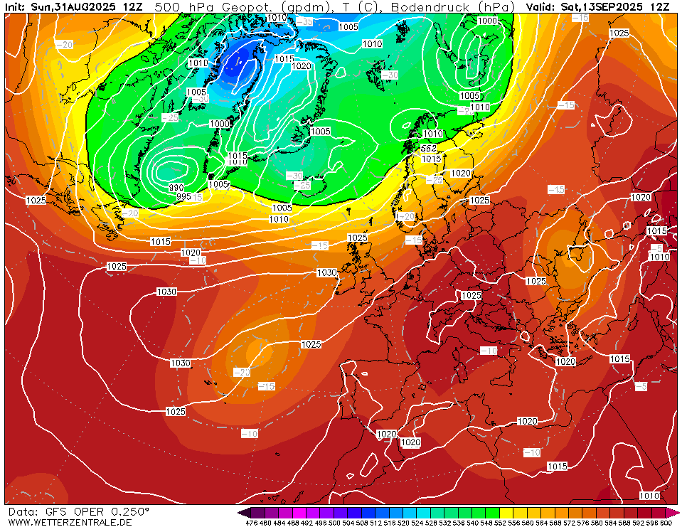
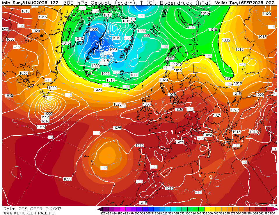
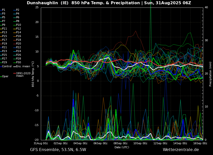
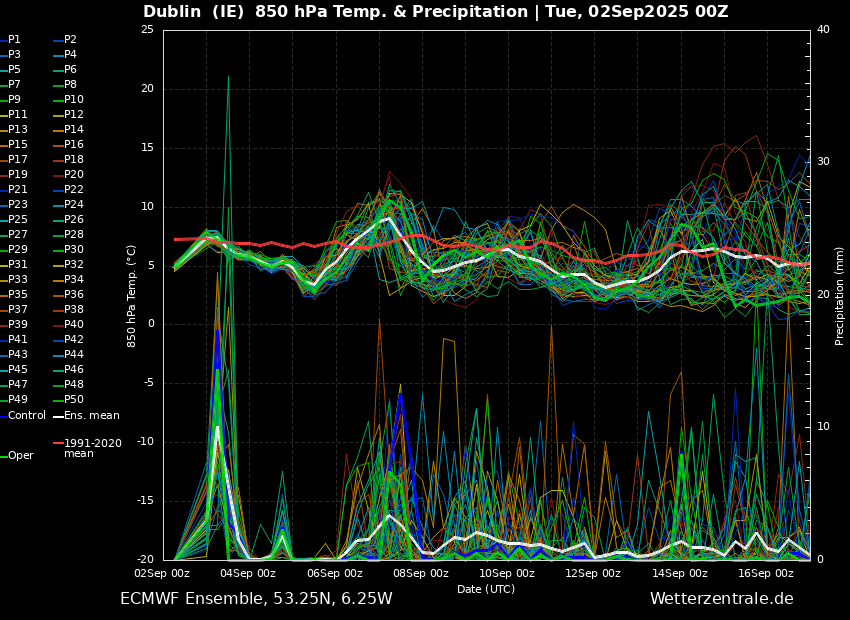
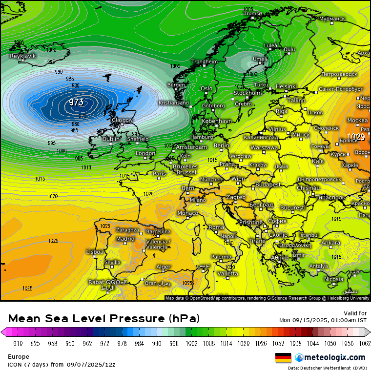
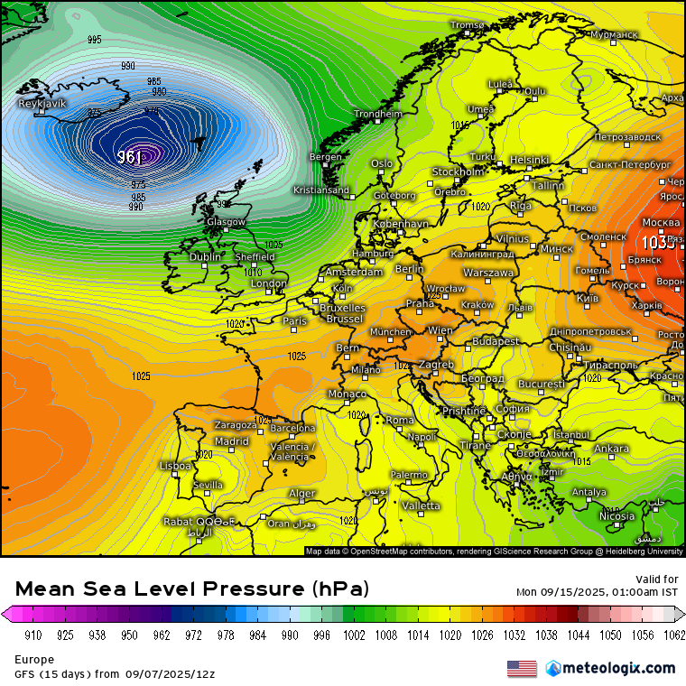
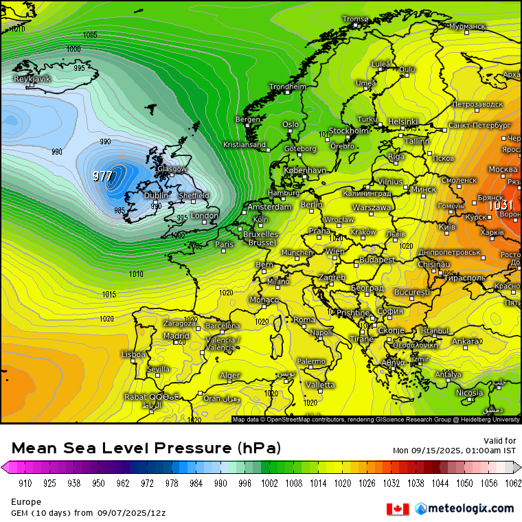
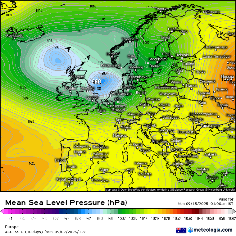
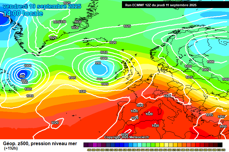
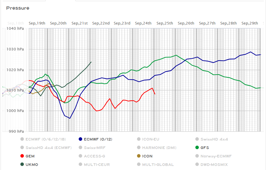
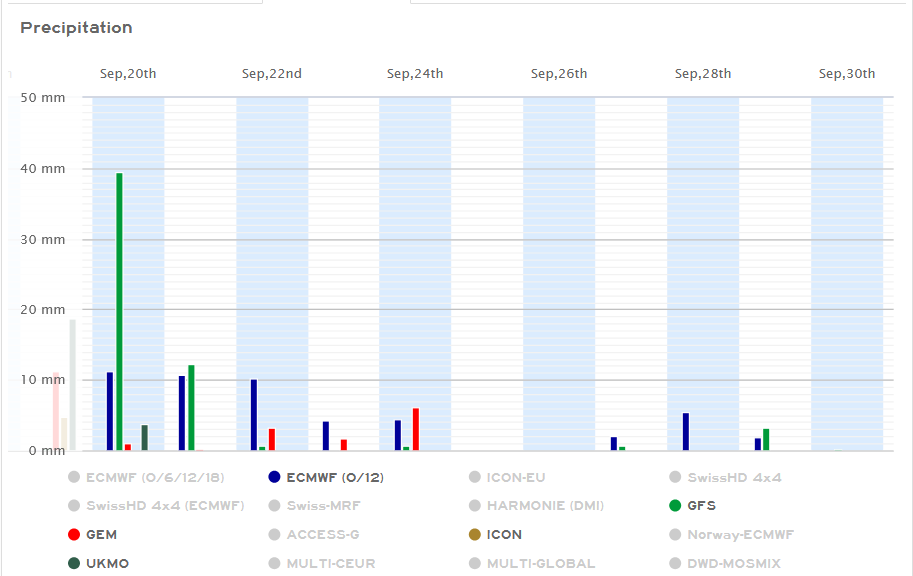
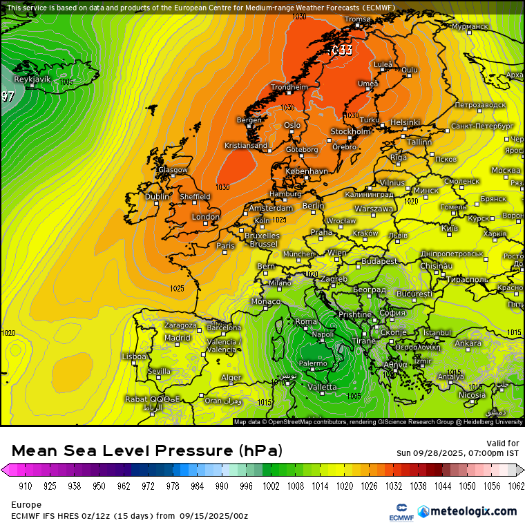
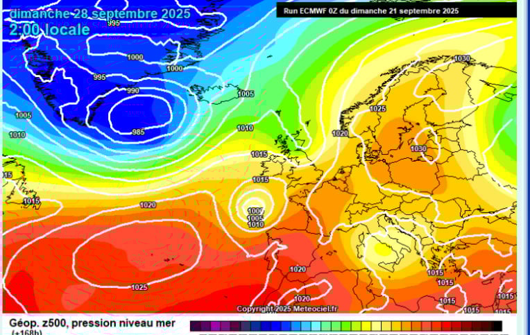
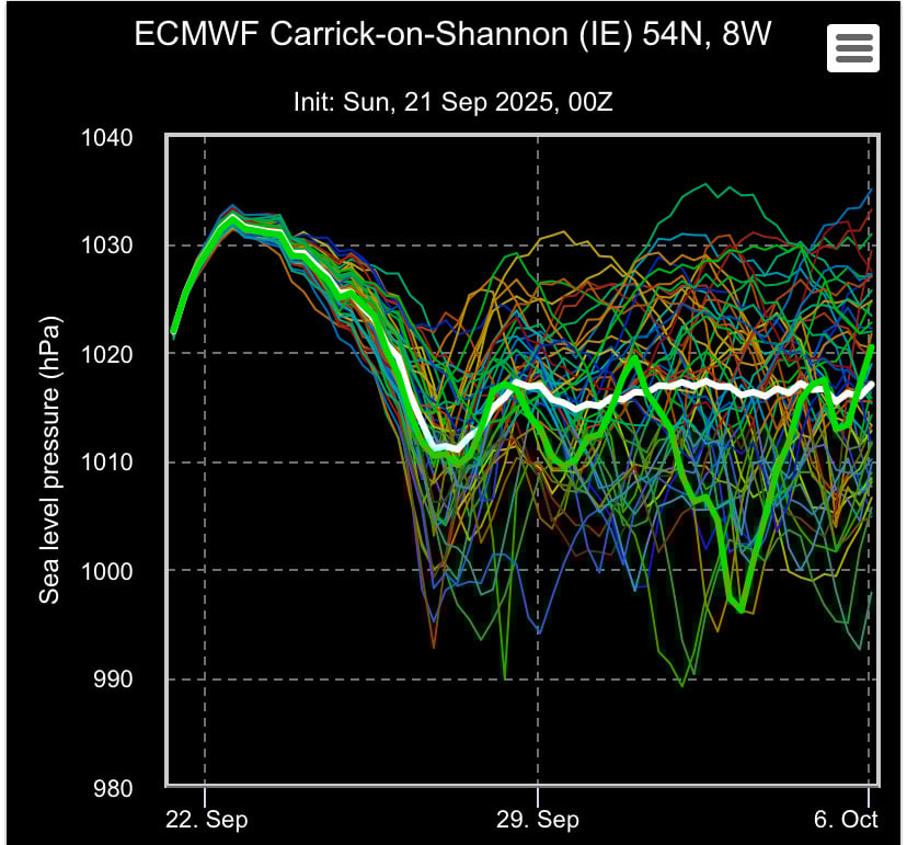
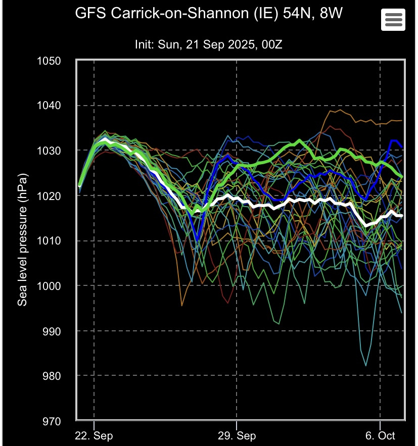
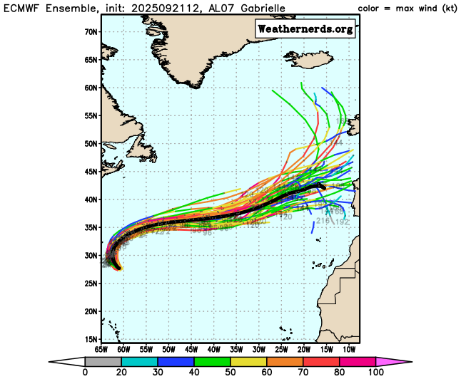
FI Charts ( T120+ onwards) Autumn 2025 **READ MOD NOTE IN FIRST

  • 31-08-2025 06:38PM
    #1
    Moderators, Science, Health & Environment Moderators Posts: 17,850 Mod ✭✭✭✭


    Mod Note:

    This thread is for posting/discussing/analyzing FI CHARTS ONLY i.e. Charts in the unreliable time frame, generally +T120 onward for Autumn 2025.

    If your post does not specifically relate to an FI chart then it doesn't belong here - Off topic posts will be moved

    Thanks

    ----------------------------------------------------------------------------------------------------------------------

    ----------------------------------------------------------------------------------------------------------------------

    I hope this is not my final time to open a new season thread here on boards as the cutoff date ends before we step into Winter. Summer 2025 was generally warm to very warm, however as we all know this warmth ended a week ago with a significant pattern change back to the form horse with a very unsettled Atlantic setup. The next 7 to 10 days looks unsettled to say the least with low pressure either over us or close by most days with showers or longer outbreaks of rain.

    Looking into FI the GFS 12z shows a nice ridge developing around mid month but a big dumpload of salt with this as it is very far away and an unsettled September from start to finish could easily happen this year.

    Unsettled all the way to September 12th, then on the 13th we see a ridge building from the Azores.

    image.png

    By the 16th this ridge firmly over Ireland which could deliver finally some settled conditions after a very unsettled couple of weeks but do we believe it!.

    image.png

    The GFS 6z ensemble run paints a very unsettled and cool period coming up with not much support for September warmth or settled conditions. This is the most unsettled ensemble run I've seen since Winter 2024/2025, not what we want to see.

    image.png

    My main wish is not weather related but for Boards to survive and make it past the autumn into the Winter season of 2025/2026 and well beyond.


«1

Comments

  • Moderators, Science, Health & Environment Moderators Posts: 17,850 Mod ✭✭✭✭Gonzo


    No change in the current modeling for first half of September, big rainfall spikes for tomorrow so a very wet day tomorrow followed a pet day on Thursday and after that looks wet with plenty of rain or showers around most days, also looks fairly cool with temperatures generally below average over the coming 2 weeks. Not seeing much wiggle room here for high pressure and one last blast of summer warmth.

    Untitled Image

    Maybe hints of a dryer trend from mid month.

    ECM no different either, perhaps even wetter than the GFS with no drying trend mid month.

    image.png

    An Atlantic dominated September looks very likely this year. Anyone looking for late summer warmth is better off booking a holiday to the Mediterranean than waiting and hoping for charts to flip to a settled outlook over Ireland.


  • Registered Users, Registered Users 2 Posts: 6,389 ✭✭✭Elmer Blooker


    September is generally a fine month and often better than August but not this year, it’s not a month that’s normally dominated by low pressure. We seem to be stuck in this pattern and I doubt if there’s any way out for the foreseeable … autumn here we come!
    I normally give summer a chance up to the equinox but …..

    68BA2B5C-0F7C-46AE-BF60-D859827E1F35.gif


  • Registered Users, Registered Users 2, Paid Member Posts: 14,257 ✭✭✭✭sryanbruen


    I wonder if we'll get some kind of settled period, brief or not, later. There's very few Septembers I can think of without one. Even September 2008 which was one of the more poor this century had a predominantly settled second half.

    image.png

    This doesn't look that different to the above.

    image.png

    Photography site - https://sryanbruenphoto.com/


  • Registered Users, Registered Users 2 Posts: 18 dairyedge2


    I’m going to Spain on September 6th but this is purely about the outlook weather period forecast, and that outlook is shite, unless your in Spain when I’m there.


  • Registered Users, Registered Users 2 Posts: 2,928 ✭✭✭sparrowcar


    Looking very stormy next Mon 8th, wind gusts of 90kph in Dublin region possible.


  • Advertisement
  • Registered Users, Registered Users 2 Posts: 3,864 ✭✭✭Dazler97


    Possible storm on Monday going by models but still a few days out yet to change , yellow and Possible orange warnings at a guess but we'll see anyway


  • Registered Users, Registered Users 2 Posts: 435 ✭✭Ros4Sam24


    Haven’t looked at the models in a while but my god what a load of 💩. Anyone jetting off this month has played a blinder…

    IMG_0872.jpeg


  • Moderators, Science, Health & Environment Moderators Posts: 17,850 Mod ✭✭✭✭Gonzo


    September 2025 shaping up to be quite the turd although we are only 4 days into the month, I don't think it's as overly wet as September 2022 was when the summer flushed on September 2nd 2022. This time around we've had it poor since about August 25th and it feels like it's been poor for a couple of weeks already.


  • Registered Users, Registered Users 2 Posts: 71 ✭✭westeast


    Sorry for hijack thead what middle to end of next week like going cutting silage in south east you can move or delete thread sorry for inconvenience


  • Moderators, Science, Health & Environment Moderators Posts: 17,850 Mod ✭✭✭✭Gonzo


    All next week is looking low pressure dominated, rain every single day and potentially stormy at times as well and temperatures generally several degrees below average. This very unsettled pattern goes right out to the end of FI at +384 hours. We're now paying the price for Spring and much of summer.


  • Advertisement
  • Registered Users, Registered Users 2 Posts: 71 ✭✭westeast


  • Registered Users, Registered Users 2 Posts: 205 ✭✭ClimateObserver


    The GFS 06Z output shows things improving from Monday September 15th.

    The problem at the moment is the Scandi High is anchored just too far east, on the Finland-Russia border and is orientated more north-south than east-west. This effectively means we've a washing machine low to the west of Ireland for the next seven days.

    The high very slowly retreats southeastwards as we head to the end of the coming week allowing lows to finally move on towards northern Norway. This movement allows a ridge of high pressure from the Azores to come in over Ireland settling things down a bit.

    The GFS then suggests an ex-hurricane west of the Azores to help shift the Azores high closer to Ireland and the UK. This seems like a reasonable evolution - however, as always - FI is just that, FI!


  • Moderators, Science, Health & Environment Moderators Posts: 13,084 Mod ✭✭✭✭Meteorite58


    All the models showing some form of disturbed weather over Ireland / UK around Sun/ Mon next. Early days but the key component is a wave forming along a very fast jet moving from Canada across to these Islands, showing a deep low /storm deepening on approach, some models showing it deepen more in to the UK and on in to Europe. Looks very wet for a time . Will see if it keeps its general track.

    Maybe the first storm of the season ?

    xx_model-en-324-0_moddeu_2025090712_180_1642_149.png xx_model-en-324-0_modusa_2025090712_180_1642_149.png

    xx_model-en-324-0_modcan_2025090712_180_1642_149.png

    xx_model-en-324-0_modaus_2025090712_180_1642_149.png

    xx_model-en-324-0_modez_2025090712_162_1642_449.png

    modez_20250915_0000_animation.gif


  • Registered Users, Registered Users 2 Posts: 6,389 ✭✭✭Elmer Blooker


    ’a very fast jet from Canada’ above says.

    I wonder what’s the cause of this when N America hasn’t even cooled down yet?
    Is the Arctic getting cold unusually early this year?

    edit: nothing unusual in the Arctic on this chart, the only storms I’ve ever seen in Sept have been ex tropical so whatever is firing up the jet is a mystery to me? Sryan said something recently about SSTs rapidly cooling in the N Atlantic so I guess that’s the explanation.

    D5288ACC-BC2D-4B9A-8C9D-80B39486CE85.png


  • Registered Users, Registered Users 2 Posts: 435 ✭✭Ros4Sam24


    Big differences between gfs and Ecmwf regarding a possible storm Sunday/ Monday.
    Ecmwf showing a stormy night on the West coast, but not as bad as recent op runs.

    IMG_0873.jpeg

    Gfs has the a weaker low well out to the Northwest, just a windy night no storm whatsoever.

    IMG_0874.jpeg

    Ecmwf and Gfs op runs are low pressure dominated with Ecm throwing out a barnstormer at day11 into the Irish Sea.

    IMG_0875.jpeg

    This chart obviously should be taken with a large pinch of salt but shows there could be a fair bit of wet and windy weather to come in the next while with any sign of high pressure getting pushed further back into September.

    IMG_0876.jpeg


  • Registered Users, Registered Users 2 Posts: 2,240 ✭✭✭adocholiday


    Juat looking at the precipitation forecast for the next week and I've never seen this before. 454mm for Mullaghmore in 7 days! But even seeing much of the westernmost fringes of the coast of Donegal getting 250-300 is very unusual. Other models are also showing a very wet 7 days for the immediate West coast but ECM is an outlier with these numbers. For reference, Markree Castle and Finner Camp are the two closest stations to here and this is 4 to 5 times their average monthly rainfall. Interesting to see if this comes to pass.

    xx_model-en-324-0_modez_2025091000_168_4863_157.png


  • Registered Users, Registered Users 2 Posts: 7,643 ✭✭✭pauldry


    Almost certain it wont come to pass. The rainfall frequency plays havoc on the models. Id say 100 to 120mm tops for these areas if even that.

    A scenario like this was shown late August early September and although it rained all of those days there was only about 7 or 8mm on average each day but the models had it at 44mm a day


  • Registered Users, Registered Users 2 Posts: 6,389 ✭✭✭Elmer Blooker


    endless! this descent into an early autumn probably caused by the ‘blob’ ?

    B049C372-24E7-4CE9-BFDF-A1AFFF18C04F.gif


  • Registered Users, Registered Users 2 Posts: 2,240 ✭✭✭adocholiday


    Some indications of things settling down a little for the end of the month? The main models all going for a rise in pressure and very little precipitation for the last week of September, although GFS and ECM diverging around the 26th. Both are showing some flimsy ridging from the Azores to Scandinavia but there's an Atlantic barrage of lows trying their best to break it down. ECM has a more entrenched high up to the end of its run but GFS has it weaker so the low pressure wins through with a sizable low pressure system off to our west on October 1st. IF ECM's modeling comes to pass we may be in with a shout of a week or two of something more settled.

    image.png image.png xx_model-en-324-0_modez_2025091500_330_1642_149.png xx_model-en-324-0_modusa_2025091500_330_1642_149.png


  • Registered Users, Registered Users 2 Posts: 2,240 ✭✭✭adocholiday


    Before we get to the end of the month we better get the boats out for this coming week and weekend. A really wet few days ahead for all areas south of what's basically a line from Dublin to Limerick, with the weekend looking particularly bad which is why I've put this in the FI thread. The American models not going for anywhere near these totals but this is fairly strong model consensus for the next 7 days. We really need a bit of a dry spell before mid-October because after that there will be little drying and it will be a long stretch until March.

    xx_model-en-324-0_modez_2025091600_144_949_157.png xx_model-en-324-0_modgbr_2025091600_144_949_157.png xx_model-en-324-0_modcan_2025091600_144_949_157.png


  • Advertisement
  • Registered Users, Registered Users 2 Posts: 435 ✭✭Ros4Sam24


    After Saturday high pressure will start to build nearby, with the models now favouring a high pretty much smack down on us. By no means a warmer high which some may be looking for still, but very useable weather with sunshine and light winds as the isobars are well spread! ☀️ ☀️

    IMG_0891.jpeg IMG_0892.jpeg

    Latest Ecmwf and Gfs runs at day7


  • Registered Users, Registered Users 2 Posts: 868 ✭✭✭Robwindstorm


    Tropical storm Gabrielle has developed and may become a hurricane by Saturday. This is the first storm in weeks due to very dry settled air and wind shear off the African coast. But athmospheric conditions look to change and the ocean is still very warm to aid storm development. The T120 + charts will be very unpredictable and the models are already showing huge variations. Hopefully this disturbed pattern in the tropics reboots our high pressure. The last thing we want is remnant storms mixing with the Jet and coming our way. It's the flip of a coin but here's hoping it falls in our favour.


  • Registered Users, Registered Users 2 Posts: 435 ✭✭Ros4Sam24


    This week still looking quite nice considering we are now 3 weeks into Autumn, with very little rain expected out till Friday

    IMG_0899.jpeg IMG_0904.jpeg

    Uncertainty creeps in around next weekend when some model runs show Tropical storm Gabrielle’s remnants approaching us, like on 0z Ecm

    IMG_0903.jpeg

    As Robwindstorm mentioned, model volatility is high when these storms form out in the Atlantic so it’s tough to give any certainty after day 5 or 6. At the moment Gfs is favouring the block over Europe to win out with Ecm slightly more inclined to favour the Atlantic winning out.

    IMG_0902.jpeg IMG_0901.jpeg

    With the sun losing strength quickly through September, most high pressure as the year progresses could be more in the way of the dreaded anticyclonic gloom like we seen so much of last winter. For this reason I would love to see the high stick around and try and salvage what is left of this soaking September so far. ☀️


  • Moderators, Science, Health & Environment Moderators Posts: 13,084 Mod ✭✭✭✭Meteorite58


    Huge uncertainty after Thurs with the remnants of Gabrielle being projected in vastly different positions in the Atlantic heading in our general direction around the weekend, although could dissipate after the Azores, even without it ECM showing a different weather system brining wet and windy weather on Fri/ Sat. UKMO tamer this evening after originally showing stormy, Can expect huge model variation with models grappling with an ex hurricane /extra tropical storm in the mix.

    AL07_2025092112_ECENS.png

    AL07_2025092112_GEFS.png image.png

    ecmwf_z500_mslp_atl_fh24-144.gif gfs_z500_mslp_atl_fh24-246.gif
    Post edited by Meteorite58 on


  • Registered Users, Registered Users 2 Posts: 1,820 ✭✭✭typhoony


    Gabrielle is still a tropical storm when it's only a couple of hundred south of Ireland this weekend


  • Registered Users, Registered Users 2 Posts: 6,389 ✭✭✭Elmer Blooker


    T shirt weather in October …. If only

    81B13D4B-0D2C-49F8-8EFA-B20E3D24493B.gif


  • Registered Users, Registered Users 2 Posts: 435 ✭✭Ros4Sam24


    Atlantic hurricane season is starting to get its act together and wreaking havoc with the weather models.

    Humberto is likely to become a hurricane overnight tonight and is the one we need to keep an eye on. Latest modelling shows Humberto missing the Us coast, and heading across the Atlantic

    IMG_0916.jpeg

    Some models show it being picked up by the jet and have some Nw Europe in the firing line

    Icon and Gfs

    IMG_0919.jpeg IMG_0920.jpeg

    With all that is happening in the North Atlantic, FI is as early as ever. Gfs and Ecmwf ensembles reflect this

    IMG_0917.jpeg IMG_0918.jpeg

    With the recent northerly spell our waters to our west have cooled. This would make it tough for weather systems to be at full force once they reach us.

    IMG_0921.jpeg

    Will be interesting to see what Humberto does over the next week but I’d imagine models will continue to struggle..


  • Registered Users, Registered Users 2 Posts: 2,240 ✭✭✭adocholiday


    ECM showing the remnants of Humberto passing relatively close to our NW next Saturday now, although GFS has nudged it further north and it's much less intense. Fairly deep low getting as low as 948hPa with a very tight gradient, but the worst of the winds staying well out to see for now. A slight southerly nudge in the direction of the jet though could bring this one to our shores. Definitely one to keep an eye on.

    xx_model-en-324-0_modez_2025092700_186_1642_149.png xx_model-en-324-0_modez_2025092700_186_4857_93.png


  • Moderators, Science, Health & Environment Moderators Posts: 13,084 Mod ✭✭✭✭Meteorite58


    Starting to feature all right adocholiday, GFS was stronger last couple of runs for Ireland but as you say tracking further away on latest run, ECM the reverse, tracking closer on latest run giving stronger winds but nothing too strong at this stage. GEM showing similar track .Interesting to see it develop, some very wet charts also out to +240hrs.

    AL08_2025092700_ECENS.png

    AL08_2025092700_GEFS.png


  • Advertisement
  • Registered Users, Registered Users 2 Posts: 6,389 ✭✭✭Elmer Blooker


    39A974D2-15F6-4A1A-8C3A-544BADC6EA3C.gif

    too good to be true so very unlikely just like those annoying day ten charts in winter


Advertisement