Advertisement
If you have a new account but are having problems posting or verifying your account, please email us on hello@boards.ie for help. Thanks :)
Hello all! Please ensure that you are posting a new thread or question in the appropriate forum. The Feedback forum is overwhelmed with questions that are having to be moved elsewhere. If you need help to verify your account contact hello@boards.ie

Interesting Maps

1324325327329330341

Comments

  • Registered Users, Registered Users 2 Posts: 4,703 Rawr
    ✭✭✭


    And to complement the name «Saltholm», the newer artificial island is called «Pepperholm» :P


  • Registered Users, Registered Users 2 Posts: 3,970 Brief_Lives
    ✭✭✭


    this is theoretically brilliant… and unappreciated…


  • Moderators, Politics Moderators Posts: 43,102 Seth Brundle
    Mod ✭✭✭✭


    Point Nemo, the most remote location on Earth, lies deep in the Pacific Ocean, 2,687 km from Antarctica. Discovered in 1992, it is so isolated that astronauts aboard the International Space Station, orbiting 417 km above Earth, are often its closest human neighbors. 🛰️🌊
    Nicknamed the "spacecraft cemetery," this desolate point serves as the final resting place for decommissioned satellites and space debris, ensuring they crash safely into the ocean. It also gained intrigue in 1997 when the enigmatic “Bloop” sound was detected—an immense, deep noise later linked to shifting icebergs beneath the sea. 🌐🧊
    A testament to Earth’s vastness and enduring mysteries, Point Nemo remains one of the most fascinating and isolated places on the planet.

    [facebook link]

    image.png


  • Moderators, Category Moderators, Arts Moderators, Sports Moderators Posts: 52,762 magicbastarder
    CMod ✭✭✭✭


    'deep in' an ocean is used in an odd way there!

    Why the pic of the island?


  • Moderators, Politics Moderators Posts: 43,102 Seth Brundle
    Mod ✭✭✭✭


    Why the pic of the island?

    It's all the one image from the link


  • Advertisement
  • Registered Users, Registered Users 2 Posts: 660 minggatu
    ✭✭✭


    Centuripe is a small town in Sicily, Italy, perched on a hilltop with views of Mount Etna. salvo-russo-600x416-1-300x300.jpg

    https://www.go-etna.de/centuripe/


  • Registered Users, Registered Users 2 Posts: 2,829 Hoop66
    ✭✭✭


    And it's a bugger to get to on an underpowered vespa. Herself had to get off and walk alongside me.


  • Registered Users, Registered Users 2 Posts: 660 minggatu
    ✭✭✭


    Decolonization in Africa - 1950 vs 1960 (Time Magazine map) two-africas-time-us-1960-v0-gird4jfgmhte1.jpg


  • Moderators, Category Moderators, Arts Moderators, Sports Moderators Posts: 52,762 magicbastarder
    CMod ✭✭✭✭


    do bluesky links work here? i can confidently say that this information did not rewrite my knowledge of the history of GIS mapping; not because i already knew but because all information contained in here is new:

    https://bsky.app/profile/pokateo.bsky.social/post/3lmbanl4ivc2d


  • Registered Users, Registered Users 2 Posts: 30,605 zell12
    ✭✭✭✭


    Former Soviet bases being modernised. Russia views this as its backyard, militarily and economically important https://www.americansecurityproject.org/russian-arctic-military-bases/

    image.png image.png


  • Advertisement
  • Registered Users, Registered Users 2 Posts: 660 minggatu
    ✭✭✭


    Names of European Languages In Their Own Language languages-europe-autonyms.jpg

    https://brilliantmaps.com/european-languages-in-their-own-language/


  • Moderators, Recreation & Hobbies Moderators, Science, Health & Environment Moderators, Technology & Internet Moderators Posts: 95,241 Capt'n Midnight
    Mod ✭✭✭✭


    image.png

    ..


  • Moderators, Politics Moderators Posts: 43,102 Seth Brundle
    Mod ✭✭✭✭


    FB_IMG_1744195767051.jpg

    (Although they're now up by a third in Ireland)


  • Registered Users, Registered Users 2 Posts: 660 minggatu
    ✭✭✭


  • Registered Users, Registered Users 2 Posts: 660 minggatu
    ✭✭✭


    Big-Mac Index 2022

    This is the price of a Big Mag in a country’s capital in November 2022.

    big-mac-index-2022-v0-5goajs3c3ste1.jpg


  • Registered Users, Registered Users 2 Posts: 40,941 ohnonotgmail
    ✭✭✭✭


    The methodology for the population stats is differs depending on the country. it is only using the city population for Ireland (hence the 0) but includes the urban population for China cities.


  • Registered Users, Registered Users 2 Posts: 660 minggatu
    ✭✭✭


    1,000 Years Of National Borders In Europe On One Map

    1000-years-europe-map.jpg

    Map created by reddit user desfirsitThe map above shows the cumulative border changes in Europe over 1,000 years in 100 year increments from 1,000 AD – 2,000 AD.

    Here’s desfirsit explaining what he did:

    https://brilliantmaps.com/1000-years-of-national-borders-europe/#more-19567


  • Moderators, Recreation & Hobbies Moderators, Science, Health & Environment Moderators, Technology & Internet Moderators Posts: 95,241 Capt'n Midnight
    Mod ✭✭✭✭


  • Moderators, Recreation & Hobbies Moderators, Science, Health & Environment Moderators, Technology & Internet Moderators Posts: 95,241 Capt'n Midnight
    Mod ✭✭✭✭


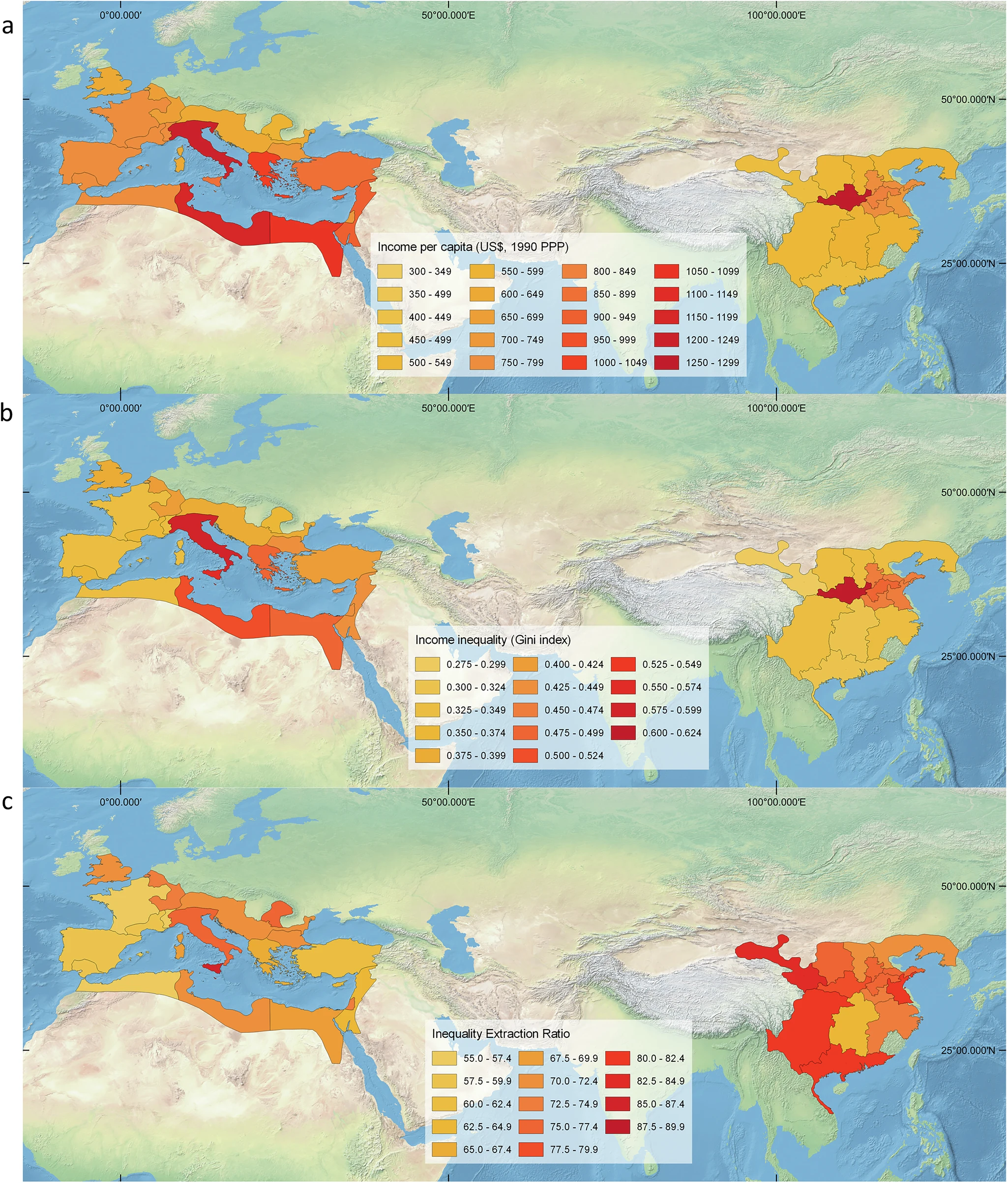
    https://www.nature.com/articles/s41467-025-58581-0

    The three maps are

    a Income per capita.

    b Income inequality (Gini index).

    c Inequality extraction.

    Untitled Image

    The emergence of vast territorial empires is a recurring development in the history of human civilization. Their ability to extract resources from their subjects, and to redistribute them, also increases the potential of higher levels of economic inequality. Here we explore how imperial structures contributed to set the level of inequality in two ancient empires, the Roman Empire ca. 165 CE and the Chinese Han Empire ca. 2 CE. We estimate the overall levels of imperial inequality as the combination of inequality between and within regions. We find that the Han Empire was, overall, more unequal and extractive than the Roman Empire. Other empires, however, were even more extractive, as shown by a comparison with the Aztec Empire ca. 1492. We argue that higher inequality increased the potential for political instability and the collapse of empires.

    image.png


  • Registered Users, Registered Users 2 Posts: 30,605 zell12
    ✭✭✭✭


    Here it is €13.50/$14.85 - so tell your J1ers to go to D.C.

    image.png


  • Advertisement
  • Registered Users, Registered Users 2 Posts: 660 minggatu
    ✭✭✭


    Why did *country* ... (Google Searches) 1brbjt9wette1.jpeg


  • Registered Users, Registered Users 2 Posts: 660 minggatu
    ✭✭✭


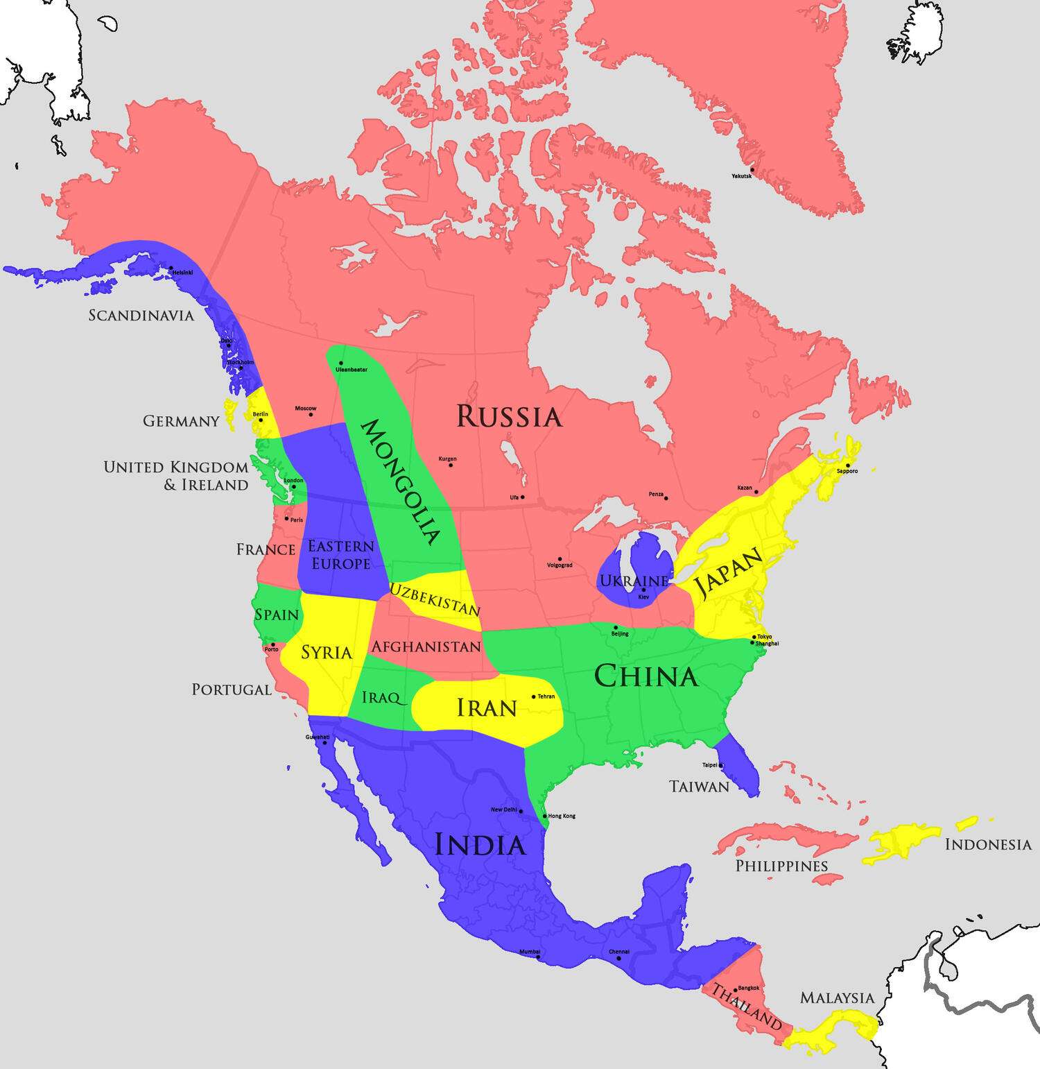
    Comparing North American climate zones to Eurasian Regions

    Comparing North American climate zones to Eurasian Regions

    https://mapsontheweb.zoom-maps.com/posts/similar-climate/comparing-us-climatic-zones-to-eurasian-regions


  • Registered Users, Registered Users 2 Posts: 660 minggatu
    ✭✭✭


    Where Nuclear Weapons Are Stored In Europe Are-there-nuclear-weapons-in-your-country.jpg


  • Registered Users, Registered Users 2 Posts: 660 minggatu
    ✭✭✭


    Left-Hand Vs. Right-Hand Traffic On Railway Lines In Eu Rail_left_right_side_Map_of_Europe.svg_.jpg

    https://brilliantmaps.com/left-hand-vs-right-hand-traffic-raillways/


  • Registered Users, Registered Users 2 Posts: 660 minggatu
    ✭✭✭


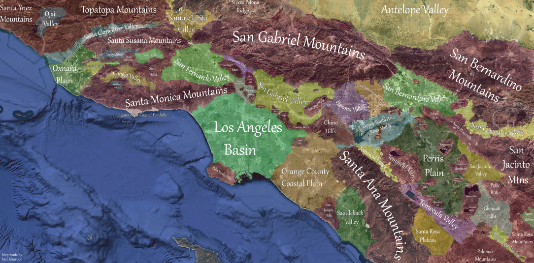
    Topographic areas of Greater Los Angeles hbxx36wqs6ue1.png

    https://www.reddit.com/r/Maps/comments/1jwn1j2/topographic_areas_of_greater_los_angeles/


  • Registered Users, Registered Users 2 Posts: 660 minggatu
    ✭✭✭


    Reported Ancestry of "Scotch-Irish" Per 1,000 People reported-ancestry-of-scotch-irish-per-1-000-people-v0-b21aztj1ohse1.jpg


  • Registered Users, Registered Users 2 Posts: 660 minggatu
    ✭✭✭


    The Length of The Great Wall Of China vs Europe great-wall-of-china-vs-europe.jpg

    more

    https://brilliantmaps.com/great-wall-of-china-vs-europe/


  • Moderators, Social & Fun Moderators Posts: 13,611 JupiterKid
    Mod ✭✭✭✭


    The highest countries in the world.

    FB_IMG_1743989084431.jpg


  • Moderators, Social & Fun Moderators Posts: 13,611 JupiterKid
    Mod ✭✭✭✭


    Population density of France & Germany compared directly, 2011

    FB_IMG_1743810123828.jpg


  • Advertisement
  • Moderators, Social & Fun Moderators Posts: 13,611 JupiterKid
    Mod ✭✭✭✭


    Plan for Amsterdam in the year 2000 by an American urban planner, 1962

    Thankfully, it was rejected at the time and never implemented.

    FB_IMG_1744055926369.jpg


Welcome!

It looks like you're new here. Sign in or register to get started.
Advertisement