Advertisement
If you have a new account but are having problems posting or verifying your account, please email us on hello@boards.ie for help. Thanks :)
Hello all! Please ensure that you are posting a new thread or question in the appropriate forum. The Feedback forum is overwhelmed with questions that are having to be moved elsewhere. If you need help to verify your account contact hello@boards.ie

Interesting Maps

1323324326328329335

Comments

  • Registered Users, Registered Users 2 Posts: 613 ✭✭✭minggatu


    Barley Produced For Beer In Europe (2022)

    author: vinemapper/instagram, added on: 2025-03-30

    Barley Produced For Beer In Europe (2022)


  • Moderators, Recreation & Hobbies Moderators, Science, Health & Environment Moderators, Technology & Internet Moderators Posts: 94,849 Mod ✭✭✭✭Capt'n Midnight


    image.png

    ..


  • Registered Users, Registered Users 2 Posts: 472 ✭✭Mullinabreena


    img_1_1743750717676.jpg

    Social and Genetic Relations in Neolithic Ireland: Re-evaluating Kinship

    This paper re-evaluates recent kinship studies in Neolithic Ireland through a close analysis of biomolecular and fine-grained archaeological data. It outlines the rich possibilities these datasets offer when interwoven to enhance our understanding of diverse webs of social relationships. We synthesize a range of archaeological and scientific data to form a new model of kinship and its relationship to shifting traditions of megalith building and funerary and cosmological practices. This model is put in dialogue with recently published genetic data and used to test a variety of explanations for the patterns of biological relatedness revealed using these methods. We argue that the detected genetic patterning is best interpreted as reflecting a reconfiguration of social relations after 3600 bc linked to the consolidation of emergent social and religious communities

    https://www.cambridge.org/core/journals/cambridge-archaeological-journal/article/social-and-genetic-relations-in-neolithic-ireland-reevaluating-kinship/C86248EEF39CA9887FE2BE9C88E62B23?fbclid=IwY2xjawJcZZxleHRuA2FlbQIxMQABHRWB49UkoavPNNvFBa744Znzgz7J69WTwBGZMOSgcc8y-2OpjYZRp0WA1g_aem_D1pIylfa9w4XfIYTWWPefA


  • Registered Users, Registered Users 2 Posts: 613 ✭✭✭minggatu


    THE TRUE SIZE of AFRICA the-true-size-of-africa-v0-fw7uhf670jse1(1).jpg

    https://www.reddit.com/r/MapPorn/comments/1jq68b3/the_true_size_of_africa/


  • Registered Users, Registered Users 2 Posts: 613 ✭✭✭minggatu


    Newborn circumcision rates by US state in 2022 newborn-circumcision-rates-by-us-state-in-2022-v0-9ekuskt849se1.jpg

    https://www.reddit.com/r/MapPorn/comments/1jp04nj/newborn_circumcision_rates_by_us_state_in_2022/


  • Advertisement
  • Moderators, Politics Moderators Posts: 42,867 Mod ✭✭✭✭Seth Brundle


    image.png

    /\


  • Moderators, Recreation & Hobbies Moderators, Science, Health & Environment Moderators, Technology & Internet Moderators Posts: 94,849 Mod ✭✭✭✭Capt'n Midnight


    image.png

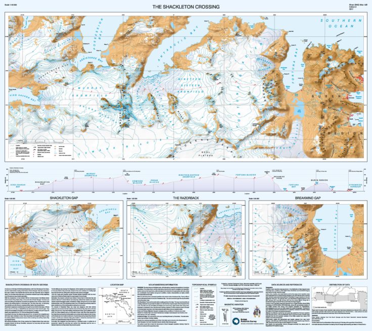
    https://www.bas.ac.uk/media-post/new-map-of-south-georgia-unveiled/

    Untitled Image

    The Shackleton Crossing (1:40 000) includes three higher resolution maps, including the more dangerous parts of the crossing, including The Razorback and Breakwind Gap, which have near-vertical descents, which the Shackleton trio Shackleton, Tom Crean and Frank Worsley slid down by tobogganing on their coiled ropes.

    image.png

    And all because the highest mountain in the UK is Mount Paget 2,934m which is more than twice the height of Ben Nevis, the highest mountain on the island of Great Britain


  • Registered Users, Registered Users 2 Posts: 423 ✭✭chosen1


    Interesting to see that Longford in the form of Annaly is the only county that largely kept its county boundary from this map to this day.


  • Moderators, Category Moderators, Arts Moderators, Sports Moderators Posts: 52,323 CMod ✭✭✭✭magicbastarder


    According to Wikipedia, south Georgia is not in the UK, but 'part of its sovereign territory'.

    https://en.m.wikipedia.org/wiki/British_Overseas_Territories

    You say tomayto?

    But if you were to claim mount Paget is validly in the UK, there's an argument you'd have to accept mount hope in the British Antarctic territory which is taller at 3,239m.


  • Registered Users, Registered Users 2 Posts: 30,278 ✭✭✭✭zell12


    Alaska is 18% of US landmass but not on image, go figure


  • Advertisement
  • Registered Users, Registered Users 2 Posts: 613 ✭✭✭minggatu


    Population density of Germany (as of 2022) population-density-of-germany-as-of-2022-v0-iex6mk6wj0te1.jpg

    https://www.reddit.com/r/MapPorn/comments/1js2ro7/population_density_of_germany_as_of_2022/


  • Moderators, Recreation & Hobbies Moderators, Science, Health & Environment Moderators, Technology & Internet Moderators Posts: 94,849 Mod ✭✭✭✭Capt'n Midnight


    image.png

    https://lordslibrary.parliament.uk/uks-relationship-with-its-overseas-territories/

    Technically there's an even higher mountain in the Antarctic , but …


  • Moderators, Recreation & Hobbies Moderators, Science, Health & Environment Moderators, Technology & Internet Moderators Posts: 94,849 Mod ✭✭✭✭Capt'n Midnight


    image.png

    ..

    Untitled Image


  • Registered Users, Registered Users 2 Posts: 4,633 ✭✭✭Rawr


    The thing about the British Antarctic Territory is that the UK have a claim on it…..but they don’t….but someday maybe they do:

    IMG_0790.jpeg

    None of the signatories of the Antarctic Treaty actively claim their slice of the continent….but they can one day, and several nations already have their slice marked out. (Marie Byrd Land is potentially the US Claim. They never followed through to discourage the USSR trying the same)

    Just to make things even more complex, the British claim is disputed with Argentina (because of course) and also Chile.


  • Registered Users, Registered Users 2 Posts: 472 ✭✭Mullinabreena


    If you look at Connacht, you'll see the counties were beginning to form around this time tpo. After the Tudor conquest, the English amalgamated the various Tuatha or Lordships. But don't forget this was only one moment in time, these borders and boundaries did change over time as Gealic chieftains were constantly raiding neighbours, switching alliances, interfighting over claims to each Rí, and so on.

    Here is a map of the Christian Diocese from the middle ages. These boundaries would largely follow boundaries of each kingdom, there was probably smaller or vasel kingdoms inside each Diocese too.

    Dioceses_of_Medieval_Ireland.jpg


  • Registered Users, Registered Users 2 Posts: 613 ✭✭✭minggatu


    The 17 Oddest Shaped Countries In The World & How They Came To Be Flag-map_of_Italy.svg_.png

    What’s Odd About Italy’s Shape?

    • Italy is unusually long and narrow, extending prominently into the Mediterranean Sea.
    • It curves sharply south-eastward, giving it a distinctive boot-like appearance.
    • It includes well-defined features:
      • The “heel” (Apulia)
      • The “toe” (Calabria)
      • The island of Sicily at its tip.

    More

    https://brilliantmaps.com/weird-country-shapes/


  • Registered Users, Registered Users 2 Posts: 6,956 ✭✭✭Badly Drunk Boy


    I like the detailed treatment given to No. 10 out of the 17 countries in that list.

    "10. Israel/Palestine

    I’m not going to touch the history of these two. Moving on…."

    Why was it even included? 😄


  • Moderators, Recreation & Hobbies Moderators, Science, Health & Environment Moderators, Technology & Internet Moderators Posts: 94,849 Mod ✭✭✭✭Capt'n Midnight


    image.png

    Chart A: Distribution of the sperm whale based on logbook records dating from 1761 to 1920. April – September, inclusive.

    image.png

    Chart B: Distribution of the sperm whale based on logbook records dating from 1761 – 1920 October—March, inclusive

    image.png

    Chart C: Distribution of northern and southern right whales based on logbook records dating from 1785 to 1913.

    image.png

    Chart D: Distribution of bowhead and humpback whales based on logbook records – mostly Nineteenth Century.

    From https://whalinghistory.org/townsends-whaling-charts/


  • Registered Users, Registered Users 2 Posts: 613 ✭✭✭minggatu


    Median wealth per Adult nwch8cnvu0te1.png


  • Registered Users, Registered Users 2 Posts: 613 ✭✭✭minggatu


    Marco Polo’s Travels, 1271 - 1295.

    marco-polos-travels-1271---1295.jpg

    https://mapsontheweb.zoom-maps.com/posts/world-history/marco-polos-travels-1271---1295


  • Advertisement
  • Registered Users, Registered Users 2 Posts: 613 ✭✭✭minggatu


    Home Price-to-Income Ratio’s Change u6mv8yx0mete1.jpeg

    https://www.reddit.com/r/MapPorn/comments/1jtjot3/home_pricetoincome_ratios_change/


  • Registered Users, Registered Users 2 Posts: 613 ✭✭✭minggatu


    Traditional dishes all across South America [ z2rujnr9lcte1.jpeg

    https://www.reddit.com/r/MapPorn/comments/1jtdtk8/traditional_dishes_all_across_south_america/


  • Moderators, Social & Fun Moderators Posts: 13,549 Mod ✭✭✭✭JupiterKid


    Satellite image of Copenhagen from space, 2024

    Copenhagen_Denmark.jpg

    The Oresund link connecting Denmark to Sweden (which I crossed at the weekend) is visible on the RHS just below the uninhabited island of Saltholm.


  • Moderators, Social & Fun Moderators Posts: 13,549 Mod ✭✭✭✭JupiterKid


    Metro system of Copenhagen, 2024

    copenhagen-metro-map.jpg


  • Registered Users, Registered Users 2 Posts: 7,145 ✭✭✭Damien360


    Why didn't they use the uninhabited landmass ? Surely it would have been cheaper to build part of it there instead of over water. There is an airport at that location to the west. Did they come inland very close to that ?


  • Moderators, Social & Fun Moderators Posts: 13,549 Mod ✭✭✭✭JupiterKid


    European countries smaller than the total estimated area devoted to car parks and roads in the USA.

    FB_IMG_1743989468449.jpg


  • Moderators, Social & Fun Moderators Posts: 13,549 Mod ✭✭✭✭JupiterKid


    Probably because Saltholm island is an important nature reserve, especially for migratory birds, thus the reason it is uninhabited.

    The Danish and the Swedes, being among the most environmentally and socially progressive peoples in the world, would have made many efforts to ensure that Saltholm was protected during the construction phase - and thus it was not used as part of the Oresund link.


  • Moderators, Social & Fun Moderators Posts: 13,549 Mod ✭✭✭✭JupiterKid


    Satellite image of O'Hare Airport in Chicago, 2024

    received_713371994347168.jpeg


  • Moderators, Social & Fun Moderators Posts: 13,549 Mod ✭✭✭✭JupiterKid


    Catchment of the Amazon River system, largest in the world

    received_1182038403644699.jpeg


  • Advertisement
  • Moderators, Recreation & Hobbies Moderators, Science, Health & Environment Moderators, Technology & Internet Moderators Posts: 94,849 Mod ✭✭✭✭Capt'n Midnight


    The Congo used to flow in to the Amazon and then into the Pacific. Back before the Andes and the Atlantic.


Advertisement