Advertisement
If you have a new account but are having problems posting or verifying your account, please email us on hello@boards.ie for help. Thanks :)
Hello all! Please ensure that you are posting a new thread or question in the appropriate forum. The Feedback forum is overwhelmed with questions that are having to be moved elsewhere. If you need help to verify your account contact hello@boards.ie

Infrastructure that never happened

1456810

Comments

  • Moderators, Sports Moderators Posts: 29,510 Mod ✭✭✭✭Podge_irl


    So yes and no. It is indeed common to have multiple routes available at single stops, however what you don't generally get is interlining in the sense of trains going from e.g. The Point to Phibsboro let's say. If you want to get from the end of one tram line to the end of another you invariably have to change tram.


  • Registered Users, Registered Users 2 Posts: 2,985 ✭✭✭mikemac2


    Ballina & Killaloe bridge between Tipperary and Clare (though Ballina likes to imagine they are in the more wealthy town of Killaloe, looking at you fake address Lakeside Hotel 🙄)

    So many years ago and maybe longer there was a plan for a new road bridge and the existing bridge would become a cyclist / pedestrian bridge. A super idea which should have happened 30 years ago but in 2023 we have no progress.

    Even local Minister Alan Kelly could not push this through.

    A bridge, hell get some students from Univerity of Limerick and it will be superb training for them and have someone experienced oversee it. One bridge is hardly the most difficult project ever

    When Ireland had no money and Minister Balfour was handing out money for uneconomical infrastructure there was a railway built between Birdhill and Killaloe. But in 2023 we cannot build a road bridge


  • Registered Users, Registered Users 2 Posts: 1,396 ✭✭✭gjim


    Construction of this new bridge (about 1km south of the existing one) and bypass - https://www.clarecoco.ie/services/capital-projects/roads-and-bridges/killaloe-bypass-shannon-bridge-crossing/ - is well underway.


  • Registered Users, Registered Users 2 Posts: 270 ✭✭Ronald Binge Redux


    And that would have increased capacity, how? Garret didn't want DART, he tried to scupper Luas. How he is thought of as 'rail enthusiast' in any way beats me. A more personable Sean Barrett.


  • Registered Users, Registered Users 2 Posts: 4,366 ✭✭✭goingnowhere


    Putting the Luas underground would have got us a German style Stadtbahn system (see Dusseldorf in particular for a city where this is really well done).

    Being able to whip along at 70kph underground with no junctions or pedestrians to dodge it would have cut a huge chunk of time off journeys and massively improved reliability


  • Advertisement
  • Moderators, Motoring & Transport Moderators, Technology & Internet Moderators Posts: 23,614 Mod ✭✭✭✭bk


    In fairness if they had cut and covered the Luas red line under abbey street, it would have solved a variety of problems with the line and other infrastructure.

    The maximum capacity of the red line is seriously constrained to the max 40meter long trams due to the distance between road junctions on Abbey Street.

    Had they made it a tunnel, they could easily have had 55m trams like the Green line or even longer Metro type vehicles.

    Also it would have avoided the issues with the junction at O’Connell St and have had a much faster journey time.

    You could then use Abbey Street as Reuther a cycling route or bus only route.

    It's common on tram networks in my experience (Dublin doesn't really have a "network" - just two lines that intersect), much less so on metro systems. Recently I used trams (and buses) in Amsterdam and Zurich which both have dense tram networks and most stops seemed to offer you the choice of more than one route.

    I know what you mean, I’ve been in plenty of cities like that, in particular all over Eastern Europe. The difference however is that in general they are using much smaller trams. Often the trams aren’t much larger than a bus, so it is more like a bus network with trams going here there and everywhere.

    The green line trams are some of the longest and highest capacity trams in the world. The green line is more approaching Metro like operation than these sort of tram networks.

    Even in those cities, when they start putting really long modern trams on, they tend to have far less interlining on those routes and run those as more like core fixed routes.

    Don’t get me wrong, I’d love for us to have an extensive tram network like these cities. Basically they have trams instead of buses. But I don’t think the interlining model is suitable for how our Luas system is designed.


  • Moderators, Science, Health & Environment Moderators Posts: 20,358 Mod ✭✭✭✭Sam Russell


    Not necessarily so.

    If the traffic warrants it, the trams would be distributed accordingly. So SSG to Heuston might be every 15 mins, while SSG to the point might be every half hour. All other trams to Parnell/Broadstone - for example. At busy mornings, Heuston to SSG might be more frequent that at say midday,

    The benefit of a network is it makes routine adjustments possible by reacting to traffic.


  • Moderators, Sports Moderators Posts: 29,510 Mod ✭✭✭✭Podge_irl


    Or just get people to change trams. Which is how most (almost all?) networks work in reality. It's easier for planning and frankly easier for the user.


  • Moderators, Sports Moderators Posts: 29,510 Mod ✭✭✭✭Podge_irl


    They also don't do interlining in the way being suggested. They also have end-to-end routes, they just share track for portions of the route. You invariably still need to change trams, you can just do so on the same platform.


  • Registered Users, Registered Users 2 Posts: 2,408 ✭✭✭KrisW1001


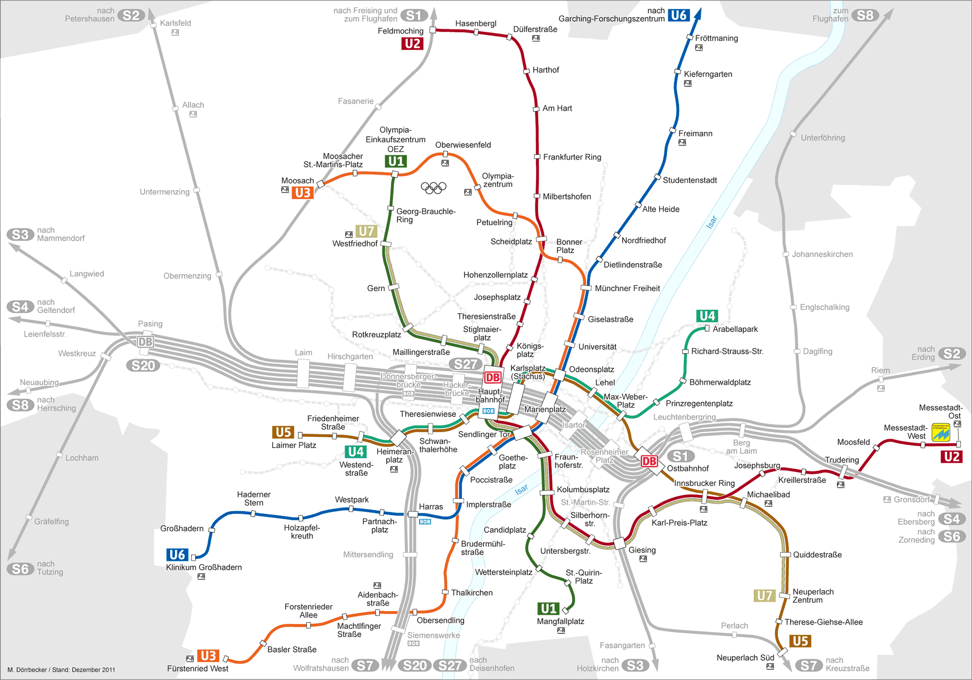
    The Munich U-Bahn has an interesting variation, in that it’s mostly three trunk lines with branches, but there are also a few strategic interlined segments that are very short - the sections where lines "cross" are usually only common for one or two stations before diverging again. Follow the path of U2 (dark red) on the map below to see what I mean.

    Untitled Image


  • Advertisement
  • Moderators, Science, Health & Environment Moderators Posts: 5,319 Mod ✭✭✭✭spacetweek


    Jesus, it would have taken you 10 seconds to look that one up!


  • Registered Users, Registered Users 2 Posts: 29,561 ✭✭✭✭breezy1985


    Much less time than typing that post 🤣

    The Granada "Metro" are buses that run 100% on bus lanes outside the city centre and then go underground for the central stops.


  • Registered Users, Registered Users 2 Posts: 468 ✭✭dublincc2


    There was a plan in the early 70s to build a ‘garden town’ in Ballyboughal in north County Dublin (article from 1973):

    IMG_6863.jpeg IMG_6864.jpeg


  • Registered Users, Registered Users 2 Posts: 3,024 ✭✭✭crushproof


    Great find, has been interesting at how rural that part of Dublin has remained despite growth elsewhere. I wonder when the name Ballyboghil changed to Ballyboughal? And I didn't realise the inital plan was to have the M1 all the way to Griffith Avenue.


  • Registered Users, Registered Users 2 Posts: 4,836 ✭✭✭FishOnABike


    Untitled Image

    Think what it could have done for tourism 😉


  • Registered Users, Registered Users 2 Posts: 468 ✭✭dublincc2


    The initial plan for the M1 was to run from Griffith Avenue to Blake’s Cross where it would terminate, a full Dublin-Belfast motorway wasn’t considered back then.


  • Registered Users, Registered Users 2 Posts: 11,982 ✭✭✭✭tom1ie


    Can I mention Luas line E?
    I can’t find a detailed PDF of the route even though someone linked to the old RPA website and there is a link to a detailed PDF map but the link doesn’t go anywhere.
    I think the route was via Rathfarnham terenure Harold’s x.

    I’d love to see a detailed map if anyone has a link.


  • Moderators, Politics Moderators Posts: 42,834 Mod ✭✭✭✭Seth Brundle


    Can't fine a Luas Line E map but this article describes the proposed route…

    The 8.4 kilometre route "most likely to be feasible" begins at Christchurch and travels down Patrick Street and Clanbrassil Street before crossing the Grand Canal into Harold's Cross.

    The line includes a single track loop between Harold's Cross and Terenure; the outbound track would travel down Brighton Square and on to Brighton Road and the inbound track would follow Terenure Road North, linking in with the outbound track at Rathfarnham Road. It would then travel on to Grange Road and Churchtown Road, terminating at The Oaks in Dundrum, where an interchange with the Luas Green would be built.

    A section of the route which would have carried the line from Christchurch over O'Donovan Rossa Bridge to Constitution Hill at Broadstone on the north side of the city, was assessed as not feasible. The study found that there were too many engineering difficulties, including the vertical clearance for a tram at Christchurch Arch, the unsuitability of the bridge and the steep decline at Winetavern Street.

    https://www.irishtimes.com/news/proposed-luas-line-would-not-meet-running-cost-1.919741


  • Registered Users, Registered Users 2 Posts: 11,982 ✭✭✭✭tom1ie


    Excellent thanks for that.

    I imagine that would be an extremely slow route when eventually built following decades of nimby objections 🤦‍♂️🤣


  • Registered Users, Registered Users 2 Posts: 7,749 ✭✭✭plodder


    I live out that general area, and was unaware of that particular proposal. Though there has been others since then, like the plan for "Vega City" (theme park, 14 hotels, 10,000 apartments, a huge conference centre and believe it or not, a monorail 😀). The article below describes it as in Lusk, but it was definitely the Ballyboughal side of the old N1.

    https://fora.ie/theme-park-dublin-lusk-vega-city-3334828-Apr2017/

    I also remember a kerfuffle about the spelling of the village name. Some of the locals were not happy about the town being associated with a "bog" and fought the government body of the time (The Placenames Commission). Looks like the locals won that battle. It's claimed that the village is named after St Patricks "staff" (Báile Bachaille) which supposedly ended up there somehow.


  • Advertisement
  • Registered Users, Registered Users 2 Posts: 415 ✭✭PixelCrafter


    Cork also escaped some pretty horrendous road designs proposed in the 1970s. There likely wasn't a budget for them in Ireland at the time, but when you look at some of those eras of urban design and road engineering, you'd wonder:

    https://www.echolive.ie/nostalgia/arid-41367985.html


  • Posts: 0 [Deleted User]


    This is not fully dead in the water, I hear that @Kermit.de.frog is lobbying hard for it and his grander plans include widening it to 19 lanes and also a petrol station in St Stephens Green park.


  • Registered Users, Registered Users 2 Posts: 72,746 ✭✭✭✭L1011


    Some smaller infrastructure, on a national scale - but not small in terms of its potential impact to where it was planned for; had it gone ahead:

    There's twice been plans to turn Rutland Island - a small-ish island in Burtonport harbour - in to something else.

    First off, there were plans for a medium sized town, to service herring fisheries and processing plants - this started construction in the 1780s. One street got built, along with some of the processing facilities; but the herring shoals moved away so the local economy collapsed.

    I have seen a street plan for it, in a book, with the author having found that in archives. Cannot find it online. Apparently much of the street layout was done, but got covered by sand dunes with no maintenance. You can still see the street and the ruined factories on aerial photography - most of the houses on the street are now holiday homes. There was a national school, a post office, a pub and a coastguard station here but all have long since closed.

    image.png

    Then, in the 70s, someone wanted to turn the entire island in to an 18 hole golf course. You can see the remaining street of houses on the map. I don't think they ever had land owners consent to go ahead with this.

    455126448_2496885703846044_3756753353097157002_n.jpg


  • Registered Users, Registered Users 2 Posts: 9,140 ✭✭✭Gregor Samsa


    Sir Hugh Lane, the Cork born art dealer, proposed building an art gallery in St. Stephen's Green, Dublin in the early 1900s. When that was rejected by Dublin Corporation, he proposed replacing the Ha'penny Bridge with a modern art gallery that would span the Liffey:

    Lutyens suggested replacing the metal bridge now known as the Ha’penny Bridge with a Ponte Vecchio-style gallery spanning the River Liffey when the proposal for a gallery located in St Stephen’s Green was rejected. The cost of the bridge gallery was estimated at £45,000 and Lane was so enthusiastic about the design that he pledged to fund any expenditure over this amount. However, the whole idea was considered as an unwarranted extravagance by William Martin Murphy and he declared it would prevent fresh sea air circulating in the slums. The proposal was narrowly defeated in a vote by Dublin city councillors in 1913. The ongoing attempt at finding a suitable location for the gallery was lampooned in cartoons published in The Herald, a paper controlled by William Martin Murphy, with one cartoon suggesting the top of Nelson’s Pillar as a possibility. Here the proposed Gallery is shown majestically taking its place alongside a busy quay crowded with trams, horses and carts and people going about their daily lives.  (source)

    200_Walcot_W.jpg

    His gallery eventually ended up becoming the Municipal Gallery of Modern Art, now the Hugh Lane Gallery, in Parnell Square. Lane himself died in the sinking of the Lusitania in 1915.


  • Registered Users, Registered Users 2 Posts: 9,140 ✭✭✭Gregor Samsa


    Speaking of spanning the Liffey, in the 1977 there was a proposal by CIE to build a massive Centeral Bus Station in Temple Bar and Ormond Quay - the two sides being linked by a tunnel under the Liffey. CIE had been buying up a lot of the property in the area with an eye for future development.

    1380510_4837923845295_1679965741_n.jpg

    https://comeheretome.com/2013/10/24/the-failed-central-bus-station-temple-bar/


  • Registered Users, Registered Users 2 Posts: 2,408 ✭✭✭KrisW1001


    That was to have had an underground rail station too: the first iteration of what would later become "DART Underground" proposed a Dublin Central Station under the CIÉ lands at Temple Bar


  • Registered Users, Registered Users 2 Posts: 7,749 ✭✭✭plodder


    An interesting one I heard about when visiting the area was the railway extension, with rather elaborate railway station (shown below) and trans atlantic port at Blacksod in County Mayo in the early 1900's. Apparently, the idea came from a plan hatched by the British government of the time to reduce the travel time from London to the furthest points of the empire, which involved taking the train to Holyhead, a short trip across the Irish Sea to Dublin, then train to Blacksod and onwards by sea to North America. This route would have kocked at least a day off the travel time using the previous route which was going by ship from Liverpool.

    Blacksod-Bay-Railway-Terminus-The-Building-News-13-October-1915-3.jpg

    https://en.wikipedia.org/wiki/Blacksod_Bay_Railway_Terminus


  • Registered Users, Registered Users 2 Posts: 160 ✭✭OisinCooke


    I do believe (although unfortunately I have no evidence on hand to back it up) that there was plans back in the mid to late 1800s I think to turn the Custom House into a very large railway terminus/station with I think a higher level (loop line bridge) and a lower terminus level. I’m not sure if plans got too far at all but I know that it was something being considered at the time… a bit mad


  • Registered Users, Registered Users 2 Posts: 72,746 ✭✭✭✭L1011


    Already mentioned, but its such a good bit of Never Happened its always worth mentioning again

    Actually built out that way was the Arranmore Whaling Company whaling station. But why was it called the Arranmore Whaling Company when it was in Mayo?

    They had planned to build the whaling station on Arranmore in Donegal; but were refused the 1900s equivalent of planning permission after they'd already done some works - blasting probably - at Pollawaddy on Arranmore.

    Streetview didn't bother going past a badly painted stop line on the road down to it, probably thinking it was a private road but there is a small harbour there now.


  • Advertisement
  • Registered Users, Registered Users 2 Posts: 468 ✭✭dublincc2


    The plan for a railway colonnade through the city centre

    https://www.archiseek.com/1837-proposed-railway-colonnade-dublin/


Advertisement