Advertisement
If you have a new account but are having problems posting or verifying your account, please email us on hello@boards.ie for help. Thanks :)
Hello all! Please ensure that you are posting a new thread or question in the appropriate forum. The Feedback forum is overwhelmed with questions that are having to be moved elsewhere. If you need help to verify your account contact hello@boards.ie

Interesting Maps

1224225227229230339

Comments

  • Registered Users, Registered Users 2 Posts: 40,398 ✭✭✭✭Mellor


    You are confusing political and geographic terms.

    The western world is a political term. The countries involved are loosely to the west, but it also includes Australia which is to the east of the middle and far east. The phrase "The West" in a global sense is a synonym of western world. But in other contexts, "The West" means something else. Context is key.

    The western hemisphere means means something very different. You have to include the word hemisphere, otherwise it's a vague adjective. The fact you were not aware of it doesn't mean other people are not.

    Yes, we all know about time zones and that it starts at zero in Greenwich but that doesn't mean most people view that line as dividing the globe into a western and eastern half.

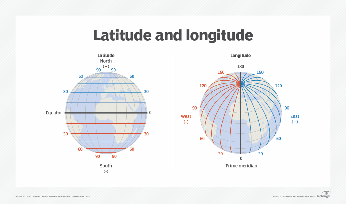
    That's quite literally how that line works. The eastern hemisphere runs east from the prime meridian to 180 degrees east. Being half a sphere. The western hemisphere, being the opposite half. The entire geographic coordinate system is based on that concept. I expect a lot of people are aware of how latitude and longitude work.

    As it's the maps thread, here is a map showing the 4 hemispheres pretty clearly.

    Untitled Image


  • Moderators, Category Moderators, Arts Moderators, Sports Moderators Posts: 52,642 CMod ✭✭✭✭magicbastarder


    i wasn't aware that there had been any consensus regarding meridians prior to the 18th or 19th century - and yes, the international date line falling where it is is good, but this seems more an accident of luck than design?

    from the royal greenwich observatory, regarding the ratification of greenwich as the prime meridian:

    "There were two main reasons for this. The first was that the USA had already chosen Greenwich as the basis for its own national time zone system. The second was that in the late 19th century, 72% of the world's commerce depended on sea-charts which used Greenwich as the Prime Meridian. The recommendation was based on the argument that naming Greenwich as Longitude 0º would be of advantage to the largest number of people.[5]"

    https://en.wikipedia.org/wiki/Meridian_(geography)


  • Registered Users, Registered Users 2 Posts: 2,201 ✭✭✭RiderOnTheStorm


    sorry, dont have a map to post in the Intersting Maps thread (boo! for shame! failed at the first hurdle!) ,,,, but in the spirit of the East / West / Lat / Long etc ..... There are 4 North Poles (and I guess, 4 South Poles to go with them...)


    True North - the top of the world where the world axle is (check a globe if unsure)

    Magnetic North - the place all the magnets point to

    Geomagnetic North - complicated , but I think its the bit under the magnetic cloud around the world? (its in Ellesmere Island , Canada)

    (N) Pole of Inaccessibility - the point on a map that is the furthest from the coast - ie the middle of nowhere - its at 85' 48" N by 176' 9" W


  • Moderators, Social & Fun Moderators Posts: 13,586 Mod ✭✭✭✭JupiterKid


    Award-winning Master Plan for the regeneration of Temple Bar, 1991

    Revolutionary for early 1990s Ireland in its modernism and vision, if only the "superpubs" hadn't been allowed to proliferate in the area after 1997...

    Temple Bar Framework Plan 1991.jpeg


  • Moderators, Social & Fun Moderators Posts: 13,586 Mod ✭✭✭✭JupiterKid


    Map of Cork Docklands Regeneration Master Plan, 2020

    LDA Cork Docklands Regen 2020 Map 1.jpg


  • Advertisement
  • Moderators, Recreation & Hobbies Moderators, Science, Health & Environment Moderators, Technology & Internet Moderators Posts: 95,133 Mod ✭✭✭✭Capt'n Midnight


    First world was countries allied with the USA, NATO, Oz, NZ, SA , Japan etc. "Western" countries.

    Second world was countries aligned with those dastardly commies the Ruskies and Chinese

    Third world was everyone else, mostly poor dictatorships.


  • Moderators, Recreation & Hobbies Moderators, Science, Health & Environment Moderators, Technology & Internet Moderators Posts: 95,133 Mod ✭✭✭✭Capt'n Midnight


    image.png

    No data 😮


  • Moderators, Recreation & Hobbies Moderators, Science, Health & Environment Moderators, Technology & Internet Moderators Posts: 95,133 Mod ✭✭✭✭Capt'n Midnight


    image.png

    Ah


  • Moderators, Recreation & Hobbies Moderators, Science, Health & Environment Moderators, Technology & Internet Moderators Posts: 95,133 Mod ✭✭✭✭Capt'n Midnight


    image.png

    ,,


  • Moderators, Recreation & Hobbies Moderators, Science, Health & Environment Moderators, Technology & Internet Moderators Posts: 95,133 Mod ✭✭✭✭Capt'n Midnight


    image.png

    ..


  • Advertisement
  • Registered Users, Registered Users 2 Posts: 27,542 ✭✭✭✭Peregrinus


  • Moderators, Social & Fun Moderators Posts: 13,586 Mod ✭✭✭✭JupiterKid


    Sorry to nitpick, but the equator is clearly in the wrong latitude here. It should be 15 degrees further South.


  • Moderators, Social & Fun Moderators Posts: 13,586 Mod ✭✭✭✭JupiterKid


  • Registered Users, Registered Users 2 Posts: 27,542 ✭✭✭✭Peregrinus


    Nitpick to the nitpick: The equator is at the right latitude, and is correctly shown. It's the continents that are wrong. They are shown well to the south of where they actually are. And Antartica has been removed to facilitate this.


  • Moderators, Social & Fun Moderators Posts: 13,586 Mod ✭✭✭✭JupiterKid


    Map of the urbanisation of Europe from the 13th to the mid 19th centuries.

    44EA8399-0269-410E-BBA9-C295B96DBF8A.jpeg


  • Moderators, Category Moderators, Arts Moderators, Sports Moderators Posts: 52,642 CMod ✭✭✭✭magicbastarder


    In the second one, Ireland has been placed pretty much right at the North pole!


  • Registered Users, Registered Users 2 Posts: 6,820 ✭✭✭Evade


  • Registered Users, Registered Users 2 Posts: 40,935 ✭✭✭✭ohnonotgmail


    By that definition Switzerland was a third world country.


  • Registered Users, Registered Users 2 Posts: 6,820 ✭✭✭Evade


    Yeah. The perception is that third world means underdeveloped but it originally meant not explicitly NATO/US or Warsaw Pact alligned.


  • Registered Users, Registered Users 2 Posts: 30,483 ✭✭✭✭zell12


    What's with the integral part of Russia, Kaliningrad? What flag is that? Also, it is misshapen in that map, as is Slovakia, as is Armenia, and Ukraine, and Belarus, and.. ok i'll stop now

    image.png


    image.png


  • Advertisement
  • Registered Users, Registered Users 2 Posts: 27,542 ✭✭✭✭Peregrinus


    By that definition Switzerland was indeed a Third World Country, as were Austria, Sweden and Finland (while, say, Nicaragua was a First World Country).

    But that sense of "Third World Country" pretty rapidly fell out of use. The countries concerned were much more likely to refer to themselves as "non-aligned", and "Third World" pretty soon came to refer to economic development rather than political alignment.


  • Registered Users, Registered Users 2 Posts: 31,060 ✭✭✭✭Wanderer78


  • Moderators, Sports Moderators Posts: 7,432 Mod ✭✭✭✭cdeb


    I think it means how badly each country would be affected in a global recession. We saw here what happened us in 2008 because we were so highly indebted. In an African country, many people probably still live subsistence lives (or at least lives that aren't as tied in to the global economy), so they would feel a recession much less. They don't have huge mortgages and so long as the crops keep growing, they's feel less of an impact.


  • Registered Users, Registered Users 2 Posts: 31,060 ✭✭✭✭Wanderer78


    makes a lot of sense, financialisation is a bit of a train wreck alright, and it ll do its best to push into less developed parts of the world to cause the exact same problems for them to, if we allow it.....


  • Registered Users, Registered Users 2 Posts: 40,398 ✭✭✭✭Mellor


    The idea of a meridian existed for thousands of years by the 18th century, in Greek antiquity. Different countries used different ones as suited them, and knowledge was limited. As the world globalised, more aligned to common meridians. Here is a list of some of the various ones used. https://en.wikipedia.org/wiki/Prime_meridian#List_of_historic_prime_meridians_on_Earth

    The international date line was not set by change. It developed some what naturally, the the pacific became the natural border where people didn't align to both east and west neighbours. But it shifted based on various colonies (Philippines, under Spain aligned to Mexico for centuries). This are all geographic influences, and would have been a major factor in the in the prime meridian being set in centre-ish europe.

    The paragraph you quote refers to the final decision between London and Paris. Two options about 2 degrees apart. The difference between the two is marginal. But the point is the other 358 degree range had been discarded by that point.


  • Registered Users, Registered Users 2 Posts: 40,398 ✭✭✭✭Mellor


    Yup. The countries are a 2D map cropped to a circle, and not a spherical projection of the countries. Neither projection is correct, but its a tiny graphic indicated the concept of lines of latitude and longitude, not a scale accurate map.

    On a related note. The global "map" that we are all familar with is not to scale. As a result, Greenland and similar places towards the poles are much smaller than people think.


  • Moderators, Recreation & Hobbies Moderators, Science, Health & Environment Moderators, Technology & Internet Moderators Posts: 95,133 Mod ✭✭✭✭Capt'n Midnight


    image.png

    ..


  • Moderators, Social & Fun Moderators Posts: 13,586 Mod ✭✭✭✭JupiterKid


    Percentage of households living in caves in Spain, 1963

    FB_IMG_1710023958771.jpg


  • Moderators, Social & Fun Moderators Posts: 13,586 Mod ✭✭✭✭JupiterKid


    Early 20th Century National Geographic map of the ethnic groups of Europe.

    FB_IMG_1710349443147.jpg

    Modern genetic studies of Europeans has debunked these categories that were based on phenotype and culture - and has revealed a much more nuanced and complex picture.

    Post edited by JupiterKid on


  • Advertisement
  • Registered Users, Registered Users 2 Posts: 6,972 ✭✭✭Badly Drunk Boy


    Roads of the Roman Empire

    RomaNS.jpeg

    Not much happening in Greece...


Advertisement